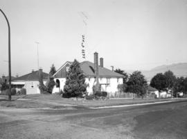
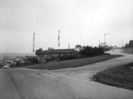
Slocan Street, west side 3rd to 4th Avenues - viwe northwest
- COV-S505-2-: CVA 772-39
- Item
- Sept 27, 1965
Part of City of Vancouver fonds
Photograph shows 2699 and 2687 East 4th Avenue
3815 results with digital objects Show results with digital objects
Slocan Street, west side 3rd to 4th Avenues - viwe northwest
Part of City of Vancouver fonds
Photograph shows 2699 and 2687 East 4th Avenue

Slocan Street, west side, 1st to 2nd Avenues - view southwest
Part of City of Vancouver fonds
Photograph shows 2696 East 1st Avenue and the rear of 2697 East 2nd Avenue

Slocan Street, west side, 1st to 2nd Avenues - view northwest
Part of City of Vancouver fonds
Photograph shows 2697 and 2691 East 2nd Avenue and a part of 2696 East 1st Avenue

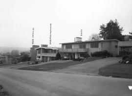
Slocan Street, west side, 4th to 5th Avenues - view northwest
Part of City of Vancouver fonds
Photograph shows 2691 and 2689 East 5th Avenue and part of 2696 East 4th Avenue

Eddington Avenue and Paton Street - southwest corner - view west
Part of City of Vancouver fonds
Photograph shows 4701 Paton Street, 2430 and 2450 Eddington Drive
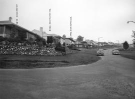
Eddington Avenue, south side, between Paton Street and Puget Drive - view southeast
Part of City of Vancouver fonds
Photograph shows 4662 Paton Street, 2430 and 2450 Eddington Drive

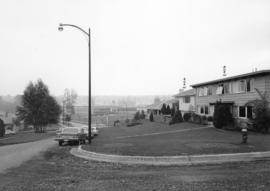
Puget Drive, east side, Eddington Avenue to lane south - view north
Part of City of Vancouver fonds
![Puget Drive and Eddington Avenue - southeast corner - view southeas[t]](/uploads/r/null/f/7/f7836b2250dcc752d9f7661a198b7bff5c0fbd20b2895526394a6408407158dd/8ab9869a-7212-4b2a-b927-4bd0dbb9bd9b-A43733_142.jpg)
Puget Drive and Eddington Avenue - southeast corner - view southeas[t]
Part of City of Vancouver fonds
Photograph shows Prince of Wales School in the background

Haggart Street, east side, from 32nd Avenue to lane north - view south
Part of City of Vancouver fonds

Haggart Street, east side, from 32nd Avenue north - view south
Part of City of Vancouver fonds
Eddington Drive, south side, from Paton Street to Haggarts Street
Part of City of Vancouver fonds
Photograph shows 2404 and 2406 Eddington Drive
Eddington Drive, south side, from Haggart Street to Paton Street - view west
Part of City of Vancouver fonds
Photograph shows 4675 Haggart Street and 2404 and 2406 Eddington Drive

Eddington Avenue, south side, between Paton Street and Puget Drive - view south west
Part of City of Vancouver fonds
Photograph shows 2450 and 2484 Eddington Avenue
Puget Drive and Eddington Avenue - southeast corner - view southeast
Part of City of Vancouver fonds
Photograph shows 4662 Puget Drive

Eddington Drive, south side between Paton Street and Puget Drive - view southeast
Part of City of Vancouver fonds
Photograph shows 2430, 2450 and 2484 Eddington Drive and 4662 Puget Drive
![[Looking north from Hastings Street along Hawkes Avenue]](/uploads/r/null/c/6/c6b7721c67508d95616838456d2e6f7fcb948b0917845c03dd2885e884026c85/090e0d28-920a-4794-bafe-7ce84481a5d2-A43725_142.jpg)
[Looking north from Hastings Street along Hawkes Avenue]
Part of City of Vancouver fonds
Photograph shows the National Harbours Board elevator
![[Hawkes Avenue at Hastings Street]](/uploads/r/null/4/3/4396259b55799a72f95a40de0cb3e84ce61fee05f34f430850ea64b1ae69c11b/d53216db-d489-4a3a-862e-f06decea401a-A43724_142.jpg)
[Hawkes Avenue at Hastings Street]
Part of City of Vancouver fonds
Photograph shows Buckshon's Pharmacy and the Rice Block at 404 Hawks Avenue
![[700 E Hastings St]](/uploads/r/null/e/d/ed03592c91e746bd2bdb2f7bd19463f38d2315e8700fb0347925fabcb17aa532/ca970500-4326-4da5-bcd5-c6553ee5fda4-A43723_142.jpg)
Part of City of Vancouver fonds
Photograph shows south side of the 700 Block East Hastings Street as viewed from the north east including the Woodbine Hotel.
![[800 E Hastings St]](/uploads/r/null/2/8/28ac1de86a0ec4e02f2ccaebd198f03b30e9d50715bfcf7843b57a82d6981417/14007932-5aa0-49f6-9caa-c7bb2c95c70a-A43722_142.jpg)
Part of City of Vancouver fonds
Photograph shows north side of the 800 Block of east Hastings Street as viewed from the southwest.

Part of City of Vancouver fonds
Photograph shows south side of the 8oo Block of Hastings Street as viewed from the north west including Buckshon's Pharmacy, Dean's Grocery, the Hastings Auditorium and the Rice Block (404 Hawks Avenue).
![[Seymour St. at Nelson St., looking east]](/uploads/r/null/6/7/674f17e26621bf88a01685886f3b90e9c81d8d4f7631a2430e620005b18466ff/7df56426-d3dd-4bfd-a460-566da7150ef1-A43720_142.jpg)
[Seymour St. at Nelson St., looking east]
Part of City of Vancouver fonds
Photograph shows Seymour Billiards.
![[Seymour St. at Nelson St., looking south]](/uploads/r/null/8/d/8d69424c601584cffb333ab74e4d1b3c00f1b2bd937c1bea590a1a4aa47e4a0c/0a8db746-af90-4c3c-9a76-617c2433e7cf-A43719_142.jpg)
[Seymour St. at Nelson St., looking south]
Part of City of Vancouver fonds
Photograph shows a portion of the Seymour Billiards sign, the Hotel Duffrin, Vancouver Ford Centre Motors and Dominion Motors.
![[Granville St. at 41st Ave, looking south]](/uploads/r/null/5/1/516132cb11f2efa4114114428bfbd5e2bb8cd393902c607a5e8cc8aa9fe9be71/07eef03d-f113-4102-ab9a-d6e7b12c1091-A43715_142.jpg)
[Granville St. at 41st Ave, looking south]
Part of City of Vancouver fonds
Photograph shows Brown Bros. Garage, Imperial Gas Station
![[Granville Street at 11th Ave, looking south]](/uploads/r/null/b/0/b0b95d9b06cf45c97e2a41efb25abec88233f2d3fd8a49a08c95b8769c61bde4/7c7f2be8-6b05-439e-b609-a6224798fc49-A43713_142.jpg)
[Granville Street at 11th Ave, looking south]
Part of City of Vancouver fonds
Photograph shows the Stanley Theatre
![[Granville Street at 12th Ave, looking south]](/uploads/r/null/3/6/362c9a59b2978778d91fd7d453d70d0b9b1047450af46648154b6a5d0b35e617/d18d91bc-c18f-4946-b8e8-6a488245cdf9-A43712_142.jpg)
[Granville Street at 12th Ave, looking south]
Part of City of Vancouver fonds
![[Granville Street at Broadway, looking south]](/uploads/r/null/a/d/ad9fb3d4863318eb2af9936be53f2590f9885be4f79a66193f9ccc3f857a8c94/ad4447d5-b4e3-4378-a692-86d3e86a5a5f-A43711_142.jpg)
[Granville Street at Broadway, looking south]
Part of City of Vancouver fonds
Photograph shows the Aristocratic cafe and Jordans.
![[Granville Street at Robson Street, looking south]](/uploads/r/null/b/3/b371abca26baa3f809d7cc470ae066f46ff9bc22b186b780de1473ae27316a73/9e85f5aa-8e90-40d5-9e65-208017bf1565-A43710_142.jpg)
[Granville Street at Robson Street, looking south]
Part of City of Vancouver fonds
Photograph shows the White Lunch, Capital, Paradise, Orpheum and Vogue Theatres, the Olympic Cafe and Cunninham Drugs.
![[Granville Street at Robson Street, looking south]](/uploads/r/null/a/a/aa31b4fb329fc0a45fc4bf57eb1ba9577b8974130b3833b770e5a34f423e5bb2/67f9af08-68f0-415e-95e6-beed8a502406-A43709_142.jpg)
[Granville Street at Robson Street, looking south]
Part of City of Vancouver fonds
Photograph shows "Theatre Row".
![[Granville Street at Georgia Street, looking south]](/uploads/r/null/f/6/f66e4185245f4f9076639ede7559052b2441ba747ee8bcf107bb8016b0f96d0a/bd46d332-24a7-4f8c-b2de-6fa604ecad5d-A43708_142.jpg)
[Granville Street at Georgia Street, looking south]
Part of City of Vancouver fonds
Photograph shows the Birks Building and clock and advertising on the side of commercial buildings.
![[Pender Street at Cambie Street, looking west]](/uploads/r/null/2/7/2774aa5bbd600e7ecc8ddebbfd0e6d705930e4d81e1bb42dde273283274b8e07/534d7f11-7691-413e-872e-4c1a9d3ee9d8-A43706_142.jpg)
[Pender Street at Cambie Street, looking west]
Part of City of Vancouver fonds
Photograph shows the Vancouver Sun sign, City Health Department building and Central Public School
![[Pender Street at Cambie Street, looking west]](/uploads/r/null/3/a/3a80c7b7e509c525c418bc41054ed92df1e0be5c3bef2d0f287cfd8db9c5fe96/332b8a52-20f2-4e06-b921-96385a7fc67c-A43704_142.jpg)
[Pender Street at Cambie Street, looking west]
Part of City of Vancouver fonds
Photograph shows the Vancouver Sun sign, City Health Department building and Central Public School
![[Photograph of a stoplight]](/uploads/r/null/7/4/74c224b383e1f94c182abad984ae1f2bf4ddfb3986b553762fdb976feabed022/fe00f732-37f2-4e7c-a3c1-f1ee5b245c8b-A43703_142.jpg)
Part of City of Vancouver fonds
![[Photograph of a stoplight]](/uploads/r/null/0/0/00e46d8380a39fb16ca7911ba995eb3d714b9477dab76e3de5807f7d1eddc65f/62994856-7cd6-450e-bbb5-5a8a896ad3b0-A43702_142.jpg)
Part of City of Vancouver fonds
![Dupont [later Pender] and Carrall Streets, looking east](/uploads/r/null/b/6/b61f681279490472ff19aa85d56f7b5c0130f41b2d92df2110e8d0ab37d1c038/208fc94b-bf89-4ce9-8ca6-ec333a66ca34-A01813_142.jpg)
Dupont [later Pender] and Carrall Streets, looking east
Photograph shows horse-drawn carriages and pedestrians along street.
![[Cordova Street] - Inauguration of Vancouver, upon occasion of the terminus of the C. P. Railway ...](/uploads/r/null/d/4/d40dc64f82d2d3aea964d571676de3247561458b888d7d3d1060fb9ae4987203/a2f6cc92-89e2-410d-8aaf-f57ce099ae65-A01812_142.jpg)
Photograph shows arch and banners along Cordova Street, as well as flags and other decorations.
![[View of Georgia Street, looking east from Court House]](/uploads/r/null/e/6/e685d2a0a674ec2e19098f87bdf09fa9c6f67c9fcca885c27b6ac21898d8fab2/1dacc653-ec4a-4f8c-9411-66cb67f90849-A04575_142.jpg)
[View of Georgia Street, looking east from Court House]
Part of Major Matthews collection
J.S. Matthews' notes with print or negative in Archives.
![[View of Georgia Street, looking east from Thurlow Street]](/uploads/r/null/3/6/36c01c361a85f43f71dfa1838bc88e69e389cfed7008895affc96b40da3840d5/a76f95e3-2e93-48b6-be2a-95c88b4a747e-A04572_142.jpg)
[View of Georgia Street, looking east from Thurlow Street]
Part of Major Matthews collection
J.S. Matthews' notes with print or negative in Archives.
![[View of Georgia Street, looking west from Howe Street]](/uploads/r/null/7/a/7a8f2e5ae4d7c33d8584740428dc308459039068a430270fb91b13c44d3047d9/6b5f6438-024d-44ca-bcb1-465663513c05-A04573_142.jpg)
[View of Georgia Street, looking west from Howe Street]
Part of Major Matthews collection
J.S. Matthews' notes with print or negative in Archives.

Vancouver, B.C. From Secord House Powell Street
Part of Major Matthews collection
Photograph shows a view of Powell Street looking west from Dunlevy Avenue. It is a composite photograph that includes the images from Str P74.1 and Str P74.2
![[Interior - Marjorie Hamilton]](/uploads/r/null/c/3/c3298fb54013a6547ca74fcc1f7954de7730fc3c81719dac2fc258826c52a2df/e9a2cd6c-87b5-4ee8-972f-918f221a5a2d-CVA810-248_142.jpg)
[Interior - Marjorie Hamilton]
![[Interior view of O.B. Allen store]](/uploads/r/null/9/6/7/96716919b46a0c4c09106d8c2bd18f0eb0666b10a3b9e97ca4b974da1b8c3231/67510557-7f2f-46fa-8b42-f0317abf2eb9-CVA1385-18_142.jpg)
[Interior view of O.B. Allen store]
Part of O.B. Allan Ltd. fonds
![[O.B. Allan store, corner of Granville and Pender Streets]](/uploads/r/null/1/f/1/1f11be96e59ea7a1ea551c558e3ab11cefe283fb3f25c4b6021f2d4db573891f/dd45c8fb-f10f-472d-a45f-baba006a0b7a-CVA1385-14_142.jpg)
[O.B. Allan store, corner of Granville and Pender Streets]
Part of O.B. Allan Ltd. fonds
![Singer Sewing Machine Building [142 West Hastings Street]](/uploads/r/null/2/5/25e7cec0d41984cbe5be8e088ff7f1e90d15485a8c83f0ac4515afa2733e100a/ad3394dd-a758-49c3-af33-42dced370509-A05584_142.jpg)
Singer Sewing Machine Building [142 West Hastings Street]
Photograph shows a view of the south side of the 100 Block Hastings Street looking east including part of the Province Building, the Empire Cafe, the Ray Building 144, The White Lunch, Trocadero at 156 W. Hastings and other businesses
![[View of the south side of the 700 and 800 Blocks of Hastings Street]](/uploads/r/null/c/9/c9a16ecf9a09cde61b3b86e48983c8f56810c67cbceb10f8aab9ebeeed5afde0/15767e7c-e06c-4520-bc90-8a65440497cb-A25196_142.jpg)
[View of the south side of the 700 and 800 Blocks of Hastings Street]
Part of Major Matthews collection
Photograph shows signs on the Williams Building (Mackinnon Block) for the Liberal Headquarters, Dr. Max M. Johnson, Cunningham's Drug Store and Leonard's Cafe, Harwood Taxi and The Pacific Building and the Credit Foncier Building
![Proposed Raymur Ave. [Avenue] Trunk Sewer diverting sewage from False Creek reclaimed area](/uploads/r/null/a/8/a8edd70876832fb32ffa8add8b5e261fe78b0e6efcb26d07a6fe1c74bf545b57/ac62eada-955d-4eee-8508-6bf4b71a21e5-MAP761_142.jpg)
Proposed Raymur Ave. [Avenue] Trunk Sewer diverting sewage from False Creek reclaimed area
Part of City of Vancouver Archives technical and cartographic drawing collection
Map shows the proposed Raymur Avenue Trunk Sewer to divert sewage away from the False Creek reclaimed area. It includes the area from Main Street to Clark Drive and from Alexander Street to Seventh Avenue. Streets and blocks are shown. The map is heavily annotated in ink and pencil to 1936. Indicated on the map are the locations of pumps, sewers, drains, and elevations; the Canadian National Railway (C.N.R.) Station, lines, industrial sites and proposed roadways; the Great Northern Railway (G.N.R.) Station and lines; a proposed rail yard; and the City Dump. Also noted is the water consumption of various companies in the area.
![Proposed Raymur Ave. [Avenue] Trunk Sewer diverting sewage from False Creek reclaimed area](/uploads/r/null/5/2/5260099e92441f23442086ea3a8b5f7512bb5b4b4b5cbf554c9f13450bf4d37f/b5165f5d-bd82-46b5-9beb-0f969f7755ef-MAP761_142.jpg)
Proposed Raymur Ave. [Avenue] Trunk Sewer diverting sewage from False Creek reclaimed area
Part of City of Vancouver Archives technical and cartographic drawing collection
Map shows the proposed Raymur Avenue Trunk Sewer to divert sewage away from the False Creek reclaimed area. It includes the area from Main Street to Clark Drive and from Alexander Street to Seventh Avenue. Streets and blocks are shown. The map is annotated in ink and pencil with regard to top and bottom fill and water levels. A pencil diagram of the pump at Parker Street has been drawn at the top of the map. Also indicated are the locations of pumps; the Canadian National Railway (C.N.R.) Station, lines, industrial sites and proposed roadways; the Great Northern Railway (G.N.R.) Station and lines; and the City Dump.
![Proposed Raymur Ave. [Avenue] Trunk Sewer diverting sewage from False Creek reclaimed area](/uploads/r/null/c/d/cddf61ac60b97b6fc54309ecbf8d1aea8e9aac3c672576fbd9953a05b82d42fc/14951fa4-0fd0-480c-a1f3-b7c2ef158398-MAP761_142.jpg)
Proposed Raymur Ave. [Avenue] Trunk Sewer diverting sewage from False Creek reclaimed area
Part of City of Vancouver Archives technical and cartographic drawing collection
Map shows the proposed Raymur Avenue Trunk Sewer to divert sewage away from the False Creek reclaimed area. It includes the area from Main Street to Clark Drive and from Alexander Street to Seventh Avenue. Streets and blocks are shown. The map was heavily annotated between 1936 and 1941, and a preliminary pumping layout to Clark Drive was added in December 1936. Also indicated are the locations of sewers, pumps, drainage and elevations; the Canadian National Railway (C.N.R.) Station, lines, industrial sites and proposed roadways; the Great Northern Railway (G.N.R.) Station and lines; a proposed rail yard; and the City Dump.

Sheet 7 : Clark Drive to Slocan Street and Seventh Avenue to Eighteenth Avenue
Part of City of Vancouver fonds
Item is a section showing the area from Clark Drive to Slocan Street and Seventh Avenue to Eighteenth Avenue. Includes streets and roads, blocks, lots, legal descriptions, railways, parks and schools. Map is hand coloured to show tax sale property for sale, property with no water, street widening and drainage, replotting, reserved land for schools, reserved land for parks, sundry land, capital assets not including schools and parks, schools, and parks, as applicable.
Vancouver (B.C.). Office of the City Engineer

Sheet 11 : Cambie Street to St. George Street and Forty-seventh Avenue to Fifty-eighth Avenue
Part of City of Vancouver Archives technical and cartographic drawing collection
Item is a section showing the area from Cambie Street to St. George Street and Forty-seventh Avenue to Fifty-eighth Avenue. Includes streets, roads, blocks, lots, legal descriptions, golf courses, parks and schools.
Vancouver (B.C.). Office of the City Engineer

Sheet B : Discovery Street to Trutch Street and waterfront to Fourth Avenue
Part of City of Vancouver Archives technical and cartographic drawing collection
Item is a section showing the area from Discovery Street to Trutch Street and waterfront to Fourth Avenue. Includes streets, roads and sewers; blocks, lots and legal descriptions; and parks and schools. Map shows Jericho Air Station and crown leases.
Vancouver (B.C.). Office of the City Engineer