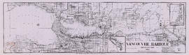
Showing 1505 results

Archival description
City of Vancouver Archives technical and cartographic drawing collection Item
Print preview View:

1194 results with digital objects Show results with digital objects

Vancouver

Item is a map showing land subdivision in the New Westminster District. The Reference index indicates that lands alienated or covered by applications under the "Land Act"; surveyed timber leases, licences, and births; and Indian reserves are noted; none of these categories of land have been colour-coded on the map. The map also shows land district boundaries; park boundaries; provincial forest boundaries; forest management licences; and municipal boundaries.

The map appears to be based on the National Topographic Series 1:250,000 map 92G, with other data added.

Vancouver

Item is a map showing land subdivision in the New Westminster District. The map shows lands alienated or covered by applications under the "Land Act"; surveyed timber leases, licences, and births; and Indian reserves; shows land district boundaries; park boundaries; provincial forest boundaries; forest management licences; and municipal boundaries.

The map appears to be based on the National Topographic Series 1:250,000 map 92G, with other data added.

Vancouver, British Columbia

Item is a map showing New Westminster Land District, including lands alienated or covered by application under the Land Act; surveyed timber leases, licences, or berths; Indian reserves; Government reserves; provincial forest boundaries; tree farm licences; municipality boundaries; and park boundaries. Includes a key plan of maps published in the same publisher's series and a reliability diagram noting data sources.

Map of the United States and territories together with Canada etc.

Item is a map showing the boundaries of U.S. territories and states and the southern portion of Canadian colonies of Vancouver Island, British Columbia, Canada East, Canada West, as well as New Brunswick, Prince Edward Island and Nova Scotia. The map also shows cities and principal geographical features. Two inset maps show "Hampton Roads and Norfolk Harbour" and "Pensacola Bay" in greater detail.

British possessions in North America

Item is a map showing British territories and borders with Russian territories, the United States, and Mexico. Includes White population totals for Hudson Bay territory, Upper Canada, Lower Canada, New Brunswick, Nova Scotia, Cape Breton Is., Prince Edward Is., and Newfoundland as well as white population for United States claimed territory, broken down by state.

Map of North America

Item is a map showing "Mr. Stuart's route through the United States, and Canada in 1828, 29 & 30" and "the boundary of the United States, both on the side of the British Possessions, & those in Mexico." The northern border of United States territory west of the Rocky Mountains is incorrectly noted at 54/40, to reflect American claims of the time.

North America

Item is a map showing portions of North American, including New Mexico, Louisiana, and Canada territories; the United States; and Native American tribal areas. The United States is depicted as their pre-revolutionary status and no international boundary is shown between the United Stated and the Canadas.

Stuart's pocket map of Vancouver, B.C.

Item is an illustrated map of the "old" City of Vancouver. The map shows streets, transportation, and significant businesses (such as C.P.R. wharves, smelter, Hastings Mill, Morse's Mill, C.P.R. Shops, City Hospital, sawmill, slaughter houses, and smallpox hospital). The map includes "Index of Streets, Government Offices, Churches, [etc.], including "Civic and other Principal Buildings", "Places of Amusement or Recreation", "Public Schools", "Principal Mills, Foundries and Manufactories", "Principle Bankers", Principal Hotels", and "Miscellaneous".

The map was designed to be folded into a cover, which is included.

Howe Sound - Burrard Inlet

Item is a topographic map in two sections showing British Columbia north of Burrard Inlet to Britannia Creek in the north, and from Howe Sound in the west to Indian Arm in the east. Map shows lakes, streams and other natural features; roads, railways, communication lines, cities and other built features; and land, timber, and mineral surveys by number.

Fraser River Delta, British Columbia

Item is a geological and topographic map covering the area of the Fraser River delta and most of the Greater Vancouver area. Map shows age and content of surface deposits; bedrock outcroppings, marshes, streams, banks and other geological features of the area; oil and gas wells and proposed drilling sites; and city streets, railways, bridges, and other built features. Includes a profile corresponding to two sections on the map: Ambleside to Vanier Park and Burrard Inlet at Burnaby Mountain to just south of the Brunette River.

200 miracle miles through the Lower Fraser Valley

Item is a tourist brochure promoting tourism in the lower Fraser Valley. The map on one side of the unfolded sheet shows locations of tourist attractions in the Lower Fraser Valley and includes an approximate mileage table. The other side of the sheet has information and photographs of some of the tourist attractions listed on map.

Indexed map of Greater Vancouver

Item is a promotional brochure for Bekins Moving and Storage Co. Ltd. The front side of the unfolded brochure includes illustrations, a street index, and a map of the company's services are for inter-city moves. The back side of the sheet shows a street map of Vancouver with concentric circles centred on the company's downtown office, showing distances in miles.

City of Vancouver, Canadian Pacific Town Site

The map shows the area currently occupied by Downtown Vancouver and parts of Kitsilano. It shows the location of C.P.R. Wharf, Royal City Saw Mills, Hastings Saw Mill and Wharf, Leamy and Kyle's Saw Mill and other saw mills. "Streets graded and side-walked marked thus . . . . .." An insert shows "Canadian Pacific Mail Steamship Lines" on a map of the world. The north shore of Burrard Inlet indicates the locations of "Indian Houses" and a mission church.

Results 301 to 350 of 1505