- AM1376-: CVA 1376-73
- Item
- [between 1940 and 1948]
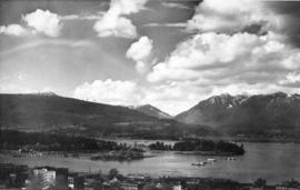
Item is aerial view from downtown Vancouver showing Coal Harbour, Deadman's Island and the North Shore Mountains.
462 results with digital objects Show results with digital objects
Item is aerial view from downtown Vancouver showing Coal Harbour, Deadman's Island and the North Shore Mountains.

View shows Lions Gate Bridge and Stanley Park.
![Georgia Day [on the deck of a] Vancouver-Victoria boat in First Narrows](/uploads/r/null/6/6/668581126068bef64727574d042412d1492c0510d297779d4bfda0ebf271604a/5b6dd093-9969-4960-850f-995e137a5ca3-A03305_142.jpg)
Georgia Day [on the deck of a] Vancouver-Victoria boat in First Narrows
![[View of] Victoria Harbour](/uploads/r/null/0/7/074ebb16365cb625f74f47be3cfe3f0ae2a9a727d6c149abfcbba485f959f53b/b1a27d9b-dbad-4511-be41-95bf15ef2fc1-A06937_142.jpg)
![[View of] Parliament Building , illuminated [at night, Victoria, B.C.]](/uploads/r/null/d/c/dc81d0d58c91faf1768ff62befeceee86d29ea5df52f6d2f0480ecd47adac3ec/efed1773-3d50-494b-8786-acab1c88657f-A06943_142.jpg)
[View of] Parliament Building , illuminated [at night, Victoria, B.C.]


Item shows Coal Harbour looking toward downtown.

Prince Rupert buildings and harbour

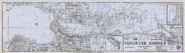
Vancouver Harbour : Sheet 3 (Second Narrows to Port Moody)
Part of City of Vancouver Archives technical and cartographic drawing collection
Item is a nautical chart of Vancouver Harbour from Second Narrows in the west to Port Moody in the east, showing soundings in fathoms, tidal information, anchorages, beacons, and waterfront businesses. Street names are shown on land areas.
![[View of] Victoria harbour](/uploads/r/null/2/e/2e8a0985a175dda5a26fef759d34134718505995fe8437669cf13a56c6b48c14/4e29bce9-209b-4aa9-b1f8-297e9d626dec-A07060_142.jpg)
![Fishing boats at Prince Rupert [docks]](/uploads/r/null/5/7/57cad72795de5981d5a1b74a4b6e885953b245c18485282f0028b8559053341c/2d2e9b4d-9594-40be-8441-6632a03ff306-A07220_142.jpg)
Fishing boats at Prince Rupert [docks]
Thor and Mikof boats indentified in photograph.
![[View of] Ocean Falls [from harbour]](/uploads/r/null/a/c/ac01a62213024629cc4ad1b26c89a5bc072b7b6495192754174509e3aa713da0/d414e587-97bb-4d8e-99e2-b8f5ef2471f8-A07225_142.jpg)
[View of] Ocean Falls [from harbour]
![[View of] Ocean Falls [harbour and buildings]](/uploads/r/null/3/3/33daeb90796231f592329cba7a2cbd32a2d2e5ec9d397a7151a925a416d514b8/860dc270-0c78-4f59-9c8e-a01712ccce45-A07221_142.jpg)
[View of] Ocean Falls [harbour and buildings]
![[View of] Deep Cove](/uploads/r/null/1/a/1a18c33f69dd89ad4f2e79c0137c837c16e817069547777a7c1f9daf2542a46f/4fe48ffe-0985-498a-acd7-92c6d74245b0-A03406_142.jpg)
![[Views of boats in] Deep Cove [harbour]](/uploads/r/null/b/9/b9f273fdf8c32c5165d86836e5ca1d3f2c41548f1aec61f7261df0be041d12a8/6a46c1b6-9ded-4685-a959-ced739e246f2-A03405_142.jpg)
[Views of boats in] Deep Cove [harbour]

Part of Major Matthews collection
Photograph shows Lions Gate Bridge, Beaver Lake, Lost Lagoon, Prospect Point, Brockton Point, Deadman's Island, Royal Vancouver Yacht Club, H.M.C.S. Discovery, Brockton Oval and English Bay.

Vancouver Harbour : Sheet 1 (First Narrows to Second Narrows)
Part of City of Vancouver Archives technical and cartographic drawing collection
Item is a nautical chart of Vancouver Harbour from First Narrows in the west to Second Narrows in the east, showing soundings in fathoms, tidal information, anchorages, beacons, and waterfront businesses. Street names are shown on land areas.

Vancouver Harbour : Sheet 2 (Point Grey to Second Narrows)
Part of City of Vancouver Archives technical and cartographic drawing collection
item is a nautical chart of Burrard Inlet and Vancouver Harbour from Point Grey in the west to Second Narrows in the east, showing soundings in fathoms, tidal information, anchorages, beacons, and waterfront businesses. Street names are shown on land areas. A Royal Canadian Air Force bombing range at Jericho Beach is identified as a danger area.
By-laws of the National Harbours Board (Vancouver Harbour)
Vancouver Harbour : plan of south shore, Burrard Inlet between Heatley Ave. and Victoria Dr.
Part of City of Vancouver Archives technical and cartographic drawing collection
Item is a map which shows parcels of land along Burrard Inlet and district lots in downtown Vancouver. Piers, factories and mills along the waterfront are identified. Soundings are shown in feet.
National Harbours Board


Vancouver Harbour, British Columbia, 1945
Part of City of Vancouver Archives technical and cartographic drawing collection
Item is a nautical chart showing English Bay and Burrard Inlet with soundings in feet, anchorages, locations of submarine cables, and ferry lines. Land features include city blocks and district lot numbers. Includes inset maps of the North Arm of Burrard Inlet and Vancouver Island. Note at the bottom of map states, "Not to be used for navigational purposes."

'Greenhill Park' ship explosion in Vancouver Harbour

Lipsett boats - "Harris No.3", "Hollyburn"
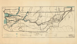
Lower Mainland Regional Plan : harbour areas
Part of Community Planning Association of Canada, British Columbia Division fonds
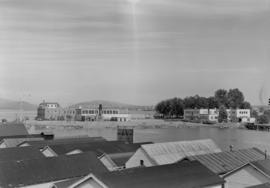
Vancouver from top of old Hotel Vancouver
Photograph shows a view looking northeast including the eastern docks

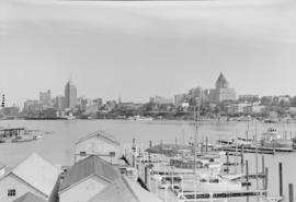
Vancouver from top of old Hotel Vancouver
Photograph shows a view looking north showing Pier B-C, the Main Post Office, the Royal Bank Building and ferries

Vancouver from top of old Hotel Vancouver
Photograph shows a view looking northeast
Photograph shows the Immigration Building, the Marine Building and Deadman's Island
Part of Major Matthews collection

Prince Rupert : misc. pix : Jack Long
Vancouver Harbour from Rowing Club, Stanley Park

Howe Sound : H.M.S.S. Discovery

Vancouver Harbour from Rowing Club, Stanley Park
Howe Sound : H.M.S.S. Discovery

Scenes : Vancouver Harbour and skyline etc.

Scenes : Vancouver Harbour and skyline etc.
Scenes : Vancouver Harbour and skyline etc.

Scenes : Vancouver Harbour and skyline etc.
![Aerial view of Ocean Falls [harbour]](/uploads/r/null/6/e/6e7b1da31432ab7db7e41f602ae5cddbf3b3c4889b489f4e532690980709637e/113f4428-192c-4424-ae49-4229a54c94ba-A03282_142.jpg)
Aerial view of Ocean Falls [harbour]
![Aerial view of Ocean Falls [harbour]](/uploads/r/null/e/f/ef9a92bc0b6b8ba55e0b9d1a94be993db8ecfc0ff976199d7aaae8bc71918c63/c6f33d55-039d-41bd-b48a-33f984667eed-A06861_142.jpg)
Aerial view of Ocean Falls [harbour]

Vancouver Harbour, foot of Cardero Street
Part of City of Vancouver fonds
Item is a photograph showing boats in the harbour at the foot of Cardero Street. Boats shown include the "Victorac" and the "Reel Fisher".
![[Aerial view] Coal Harbour and Deadman's Island](/uploads/r/null/4/a/4a67a24f9b0323de5c85adc302a165b41d7406154f7c77d79e1322518c819b8b/406e5e08-4114-4cc0-b260-612267ba3842-A23517_142.jpg)
[Aerial view] Coal Harbour and Deadman's Island
Part of Major Matthews collection
Oblique view. Photograph shows the Royal Vancouver Yacht Club and the HMCS Discovery military base.
What is the National Harbours Board?

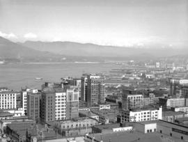
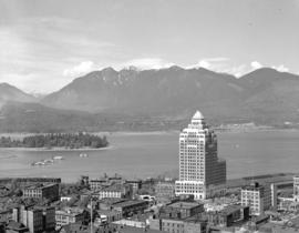
Downtown Vancouver from high vantage point
Item is a photograph of downtown Vancouver looking northwest from the upper floors of an unidentified building. The view includes the Marine Building, Coal Harbour, Vancouver Harbour, and the north shore.

Item is a photograph of an unidentified freighter loading lumber at a pier in Vancouver.