
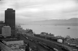
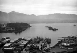
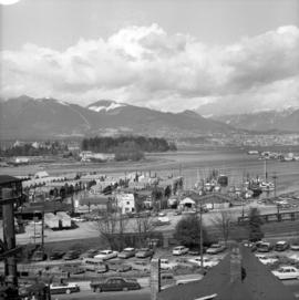
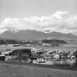
British Columbia - Vancouver skyline

British Columbia - Vancouver skyline

British Columbia - Vancouver skyline
British Columbia - Vancouver skyline

British Columbia - Vancouver skyline

British Columbia - Vancouver skyline

British Columbia - Vancouver skyline

British Columbia - Vancouver skyline

British Columbia - Vancouver skyline
British Columbia - Vancouver skyline

British Columbia - Vancouver skyline

British Columbia - Vancouver skyline
Through the Canadian Pacific Rockies : a large scale map of the mountains from Calgary to Sicamous
Through the Canadian Pacific Rockies : a large scale map of the mountains from Calgary to Sicamous
Cleaning for new site

Cleaning for new site
Cleaning for new site

Cleaning for new site
Elm Park, Winnipeg, Man.
![[Sheet 4 : Chilco Street to Burrard Street and Robson Street to Deadmans Island]](/uploads/r/null/9/4/9482209e02b8dc04c79ef404276e1d40bcbb4fab0330b4aa744e352ae9440921/5597738a-70b2-4cfc-a802-6a076987c33d-MAP339_142.jpg)
[Sheet 4 : Chilco Street to Burrard Street and Robson Street to Deadmans Island]
![[Sheet 5 : Stanley Park to Nicola Street and English Bay Beach to Robson Street]](/uploads/r/null/1/d/1daf1ff2196704e4e82a6b5c7476ee3e8a46b4e0740f3c37f3f58813f5f8b5f0/ee3a2706-4ebe-4ee8-b4db-da89840c7f89-MAP339_142.jpg)
[Sheet 5 : Stanley Park to Nicola Street and English Bay Beach to Robson Street]
![[Sheet 6 : Nicola Street to Beatty Street and English Bay Beach to Georgia Street]](/uploads/r/null/f/2/f2effc97084427c0bd73bae3566d3ad910caaa6e7fb3e5ed9f3ece81bd2ac0a1/f2cc48a6-1195-4dd8-8227-71d36d1791bb-MAP339_142.jpg)
[Sheet 6 : Nicola Street to Beatty Street and English Bay Beach to Georgia Street]
![[People walking in snow at Stanley Park]](/uploads/r/null/1/1/116bb50e42d368767c847278dff718405623624bb66fd0d4bd89b05e58c78813/6bbf4ddf-c995-46d6-b316-ea2d9eeafa12-A20567_142.jpg)
[People walking in snow at Stanley Park]
![[Island in lake, Stanley Park]](/uploads/r/null/f/4/f4d03a172f03857093502f4e38e059e76506cadffcbbb9111d36d92acbc39ea5/e1739b94-63f7-41ca-9414-f94a792179aa-A20570_142.jpg)
[Island in lake, Stanley Park]
![[Sir Wilfrid Laurier aboard passenger ship]](/uploads/r/null/8/c/8cb3518b43f250af3c401f77dddc7cf48871685ddd8cd35408f01fcef54004d3/bc6c568f-9603-4197-95ba-4e7415f32d67-A36142_142.jpg)
[Sir Wilfrid Laurier aboard passenger ship]
![[Sir Wilfrid Laurier aboard passenger ship]](/uploads/r/null/a/2/a2c52de924a552bb7e81200391b535d25f0e8e0727db6dc24a7290e387214a54/72510173-02b1-48d8-86d1-54c79471e85c-A36141_142.jpg)
[Sir Wilfrid Laurier aboard passenger ship]
![[View of Stanley Park looking north-east]](/uploads/r/null/f/7/f7d884fca7d6610a84095f63eeb14e608621d689a79853817d21a13f6a3be936/15307645-0edd-40b9-8e24-19acd1863822-A36140_142.jpg)
[View of Stanley Park looking north-east]

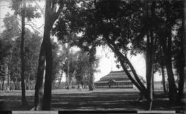
Victoria Park

Free map of Vancouver, New Westminster and surroundings
![[Snow in park]](/uploads/r/null/e/b/8/eb840b195ec483461bf0e13d67577358b11554b45b5687e96d721163b1c7dd74/bc340b55-baba-419c-91bf-3e6e0bd36ac3-CVA7-309_142.jpg)
[Snow in park]
![[View of park, Santa Catalina Island]](/uploads/r/null/2/a/2a88cb40d3d79ae1b059f9d840d9bfac5f29caada17e42a4d7be5e308d27585a/e0e9b034-c4b1-429a-aca5-feb059d13ade-CVA1477-510_142.jpg)
[View of park, Santa Catalina Island]

Sheet 1 : Slocan Street to Boundary Road and Triumph Street to Burrard Inlet

Sheet 2 : Slocan Street to Boundary Road and Charles Street to Triumph Street

Sheet 3 : Slocan Street to Boundary Road and Seventh Avenue to Charles Street

Sheet 4 : Slocan Street to Boundary Road and Broadway to Seventeenth Avenue

Sheet 5 : Slocan Street to Boundary Road and Seventeenth Avenue to Twenty-ninth Avenue

Sheet 6 : Knight Street to Slocan Street and Eighteenth Avenue to Twenty-ninth Avenue

Sheet 7 : Clark Drive to Slocan Street and Seventh Avenue to Eighteenth Avenue

Sheet 8 : McLean Drive to Slocan Street and William Street to Seventh Avenue

Sheet 9 : Clark Drive to Slocan Street and Triumph Street to Charles Street

Sheet 10 : Clark Drive to Slocan Street and waterfront to Triumph Street

Sheet 11 : Carrall Street to Clark Drive and waterfront to Keefer Street

Sheet 12 : Ontario Street to Clark Drive and Keefer Street to Second Avenue

Sheet 13 : Ontario Street to Clark Drive and First Avenue to Sixteenth Avenue

Sheet 14 : Main Street to Knight Street and Fifteenth Avenue to King Edward Street

Sheet 15 : Oak Street to Main Street and False Creek to Sixteenth Avenue

Sheet 16 : Maple Street to Oak Street and False Creek to Sixteenth Avenue

Sheet 17 : Trutch Street to Maple Street and Fourth Avenue to Sixteenth Avenue

Sheet 18 : Trutch Street to Maple Street and English Bay to Third Avenue

Sheet 19 : Maple Street to Richards Street and Drake Street to Third Avenue

Sheet 21 : Burrard Street to False Creek and waterfront to Robson Street