- COV-S639-2-F13-: CVA 791-0350
- Item
- Dec. 1985
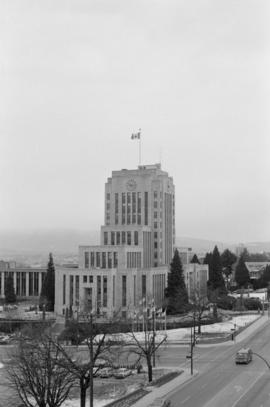
Part of City of Vancouver fonds
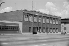
Item is a photograph showing City Hall.
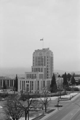
Part of City of Vancouver fonds
Item is a photograph showing City Hall.
Part of City of Vancouver fonds
Item is a photograph showing City Hall.

Part of City of Vancouver fonds

Part of City of Vancouver fonds

Part of City of Vancouver fonds

Part of City of Vancouver fonds

Part of City of Vancouver fonds

Part of City of Vancouver fonds

Part of City of Vancouver fonds
Part of City of Vancouver fonds

Part of City of Vancouver fonds

Part of City of Vancouver fonds
Part of City of Vancouver fonds
Part of City of Vancouver fonds

Part of City of Vancouver fonds

Part of City of Vancouver fonds

Part of City of Vancouver fonds
Part of City of Vancouver fonds
![Contour plan 220a [Mt. Pleasant]](/uploads/r/null/b/d/bd5c7afeea1a507ba6bc282b904c55c40d1119da939738b1911ba9fd99e6bd21/21ae5b59-321b-4488-bdc6-e782f391b8ea-MAP690_142.jpg)
Contour plan 220a [Mt. Pleasant]
Part of City of Vancouver fonds
Item is a map showing the topography of the area south of False Creek to 15th Avenue in the south and from Glen Drive in the east to Bridge Street (now Cambie Street) in the west.

Part of City of Vancouver fonds

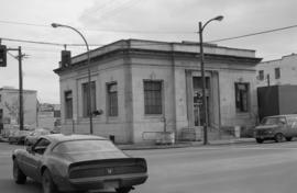
W. 4th Avenue & Manitoba Street
Part of City of Vancouver fonds

Part of City of Vancouver fonds

Part of City of Vancouver fonds
Part of City of Vancouver fonds

Part of City of Vancouver fonds

Corner 5th Avenue and Cambie Street
Part of City of Vancouver fonds

Part of City of Vancouver fonds

Part of City of Vancouver fonds

Part of City of Vancouver fonds

Part of City of Vancouver fonds

Part of City of Vancouver fonds
Part of City of Vancouver fonds

Part of City of Vancouver fonds

Part of City of Vancouver fonds

Part of City of Vancouver fonds

Part of City of Vancouver fonds

Part of City of Vancouver fonds
Part of City of Vancouver fonds

Part of City of Vancouver fonds

Part of City of Vancouver fonds

W. 4th Avenue & Ontario Street
Part of City of Vancouver fonds
![David L. Jones [wholesale florist], Wylie Street and W. 1st Avenue](/uploads/r/null/b/4/c/b4c819d9d656eb30d8a4f33dc80065703c7c90b95fce9c1880eddaba3fd82210/8634ab24-f2e2-4506-9f99-c4139d53fda6-CVA786-23_142.jpg)
David L. Jones [wholesale florist], Wylie Street and W. 1st Avenue
Part of City of Vancouver fonds
![Opsal Steel Ltd. [97 E. 2nd Avenue]](/uploads/r/null/2/3/2/232ac779d96989d15d252741cab0695612ef729cc1e731fed9f739c897c3c296/73ecb72a-8d0f-48c3-802c-9e9b06d7b626-CVA786-23_142.jpg)
Opsal Steel Ltd. [97 E. 2nd Avenue]
Part of City of Vancouver fonds
Item is a photograph showing Opsal Steel Ltd. Logging Equipment.
Part of City of Vancouver fonds
![MacLean and Powell Iron Works [398 W. 2nd Avenue]](/uploads/r/null/f/9/8/f986bc6060192088b257d9d2664c0ff0099550d7a9724803ef6a2c5d67322157/34d4cb26-be8f-45e1-af41-62df56633feb-CVA786-23_142.jpg)
MacLean and Powell Iron Works [398 W. 2nd Avenue]
Part of City of Vancouver fonds
![MacLean and Powell Iron Works [398 W. 2nd Avenue]](/uploads/r/null/d/e/1/de1bd2331d8f38729f62a271796726cfd094a2e754ddbd1ac5e7de6cc53a1314/a1f0c6aa-e324-41b1-a8c2-6288e3ce8e8d-CVA786-23_142.jpg)
MacLean and Powell Iron Works [398 W. 2nd Avenue]
Part of City of Vancouver fonds

Part of City of Vancouver fonds
Item is a photograph showing Martin & Stewart B.C. Ltd. Hides and Skins.

Part of City of Vancouver fonds
Item is a photograph showing Martin & Stewart B.C. Ltd. Hides and Skins.
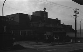
Part of City of Vancouver fonds
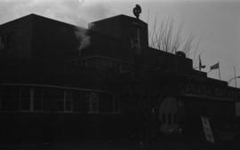
Item is a photograph showing the B.C. Tel Car and Truck Mobile Tel Service Centre plant building.
Part of City of Vancouver fonds