
- AM54-S4-1-M-4-: M-4-6
- Item
- [between 1910 and 1929]
Part of Major Matthews collection
Photograph shows hikers wearing snowshoes
Part of Major Matthews collection
Photograph shows hikers wearing snowshoes

Part of Major Matthews collection

Part of Major Matthews collection
Part of Major Matthews collection

Part of Major Matthews collection
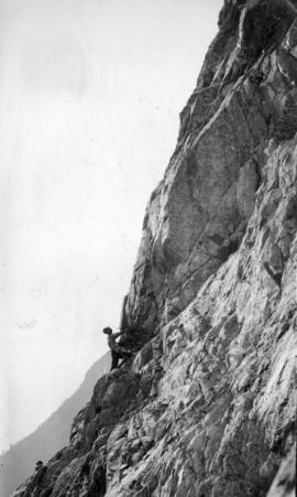
Photograph shows a hiker

Part of Major Matthews collection
Photograph shows two hikers taking a rest
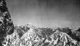
![Looking west from [The] Lions](/uploads/r/null/7/1/719d0699f187b0983e38774dd46a1514cfb9ea70aae806cf6ae4c3ee48b4e143/8ac1f4b9-3627-4877-bc4c-d33c9305e660-A22649_142.jpg)
Part of Major Matthews collection

Part of Major Matthews collection

Part of Major Matthews collection

Part of Major Matthews collection
Part of Major Matthews collection

Part of Major Matthews collection
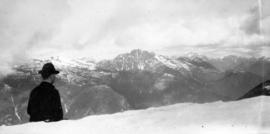
Photograph shows The Lions in the background

Part of Major Matthews collection
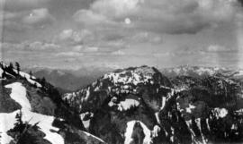
![Between Mount Brunswick and [The] Lions](/uploads/r/null/d/2/d2d1d71e16ff928ab1f6487fe480b840fae7705d70bee2f54c575db9d4cb2c8d/2ba235be-afe7-460d-91b7-18500714c0d5-A22655_142.jpg)
Between Mount Brunswick and [The] Lions
Part of Major Matthews collection

Part of Major Matthews collection

Part of Major Matthews collection

Part of Major Matthews collection

Part of Major Matthews collection

Part of Major Matthews collection

Part of Major Matthews collection

Part of Major Matthews collection

Part of Major Matthews collection
Photograph shows snow covered trees and Point Grey in the background

Part of Major Matthews collection

Part of Major Matthews collection

Part of Major Matthews collection

Part of Major Matthews collection

Capilano Canyon showing cedar bolt flume
Part of Major Matthews collection

Part of Major Matthews collection

Part of Major Matthews collection

Looking west from Mount Seymour
Part of Major Matthews collection

Part of Major Matthews collection

Part of Major Matthews collection
Part of Major Matthews collection

Part of Major Matthews collection
Cathedral Mountain from Mount Seymour
Part of Major Matthews collection

Part of Major Matthews collection

White Mountain from Cathedral Mountain
Part of Major Matthews collection
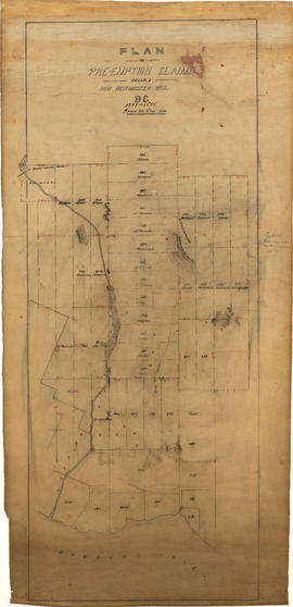
Plan of pre-emption claims, group 1, New Westminster District B.C., 1887-1888
Part of Major Matthews collection
Item is a map depicting pre-emption claims in Group 1, New Westminster District, a section of land extending north from Burrard Inlet and including Capilano Creek. The majority of claims are numbered and/or include the owner's last name. In addition to creeks, the map also shows the location of a waterworks dam, mountains, and high hills. Pencil annotations indicate the location of "Trythall's Clearing."

Map of portion New Westminster District
Part of Major Matthews collection
Item is an annotated tracing of a map showing the future sites of Vancouver, Burnaby and the North Shore from an area bordering on English Bay to an area bordering on North Arm. Traced over by J.S. Matthews in 1954, it illustrates intended land settlement and subdivision in 1877. Also shown are bodies of water, Hastings & Granville Road, and the settlements of Hastings and Granville. Annotations are an introductory note by Matthews in August 1954 titled "Before Greater Vancouver." Enclosed with the map are four letters between J.S. Matthews and W.H. Hutchinson, Chief of the Geographic Division of the B.C. Survey and Mapping Branch of the Department of Lands and Forests, in 1954 concerning the map's provenance and Matthew's efforts to increase the legibility of copies of the original map.

Part of Major Matthews collection
The map is a draft of MAP 56.01, "Indian villages and landmarks, Burrard Inlet and English Bay, before the whiteman came." It shows the geographic area bounded by the north shore of Burrard Inlet, the Freaser River, Point Atkinson, and the Burrard Inlet Second Narrows. Shown on the map are locations of First Nations and European settlements, streams, coastal features, and inland vegitation. Physical features are labeled using both First Nations and European place names.

Draft map of Indian villages and landmarks, Burrard Inlet and English Bay, before the whiteman came
Part of Major Matthews collection
The map is a draft of map 56.01, "Indian villages and landmarks, Burrard Inlet and English Bay, before the whiteman came." It shows the geographic area bounded by the north shore of Burrard Inlet, the Fraser River, Point Atkinson, and the Burrard Inlet Second Narrows. Shown on the map are coastal sites labeled with First Nations place names.

Part of Major Matthews collection
The item is a table of place names shown on map 56.01; Indian villages and landmarks, Burrard Inlet and English Bay, before the whiteman came. The table gives First Nations names and their approximate english meaning, or the European name given to the same location.
![[View of North Vancouver from across Burrard Inlet]](/uploads/r/null/f/3/f3f3752f66509bf91857f1790e0ef7e59de6f1125cf77326c5529552883a1768/d3c54dd1-21f8-4c66-9168-2d130918fd9b-A32575_142.jpg)
[View of North Vancouver from across Burrard Inlet]
Part of Major Matthews collection
Panoramic view
![[View of North Vancouver from across Burrard Inlet]](/uploads/r/null/1/0/1000de853825031b1e00379ca07992e10f31302eb2d00e9a14c288b099176366/757aec20-76f0-451d-b3ae-b0d3e08ea726-A32576_142.jpg)
[View of North Vancouver from across Burrard Inlet]
Part of Major Matthews collection
Panoramic view
![[View of North Vancouver from across Burrard Inlet]](/uploads/r/null/1/8/189ba35cb06084777fb2bda228ad93f3576931c505a2e6b41a11dcde757d3772/4ed44799-0b6d-4458-bc85-5202c7143989-A32577_142.jpg)
[View of North Vancouver from across Burrard Inlet]
Part of Major Matthews collection
Panoramic view
![[General McNaughton and General Pearkes inspect cadet camp in Mahon Park]](/uploads/r/null/8/6/865fe23237d0fc9146a5a46421f8a06f2d6c7e2e66692b76ed70c849108a76d2/48abcd65-4512-42f5-82ed-1a25f7ef1857-A32323_142.jpg)
[General McNaughton and General Pearkes inspect cadet camp in Mahon Park]
Part of Major Matthews collection
![[General McNaughton inspects cadet camp in Mahon Park]](/uploads/r/null/6/c/6cf17298b99ceb4d24d584199e71e3a5058d434acff9c19969540706335bd736/1dea5b94-6665-4969-8ba7-e709d013c5c2-A32324_142.jpg)
[General McNaughton inspects cadet camp in Mahon Park]
Part of Major Matthews collection
![[North Vancouver Engineers, 1st Detachment prior to going overseas]](/uploads/r/null/3/e/3eef25d2eaccf375d89d7d17479f8b8d60bec414d73f5d649540e1548b77c275/dc24c7cd-1151-4668-9793-d9903729f60b-A32076_142.jpg)
[North Vancouver Engineers, 1st Detachment prior to going overseas]
Part of Major Matthews collection
![[North Vancouver Engineers practice digging trenches]](/uploads/r/null/e/c/ec2b84c6c93219c23175bada11968b102d0d7a667231ed2f79b49bcaad012f44/47a0b104-1bbd-4191-9c0f-80d8c92493bd-A32077_142.jpg)
[North Vancouver Engineers practice digging trenches]
Part of Major Matthews collection

Moveable Anti Aircraft Screen. Open. 6th Field Company C.E.
Part of Major Matthews collection
Photograph shows soldiers in a trench