
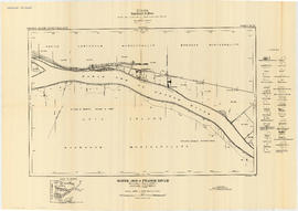
Fraser River - Sand heads sheet
- AM1594-MAP 1157-: LEG1153.042
- Item
- 1921
Part of City of Vancouver Archives technical and cartographic drawing collection
1440 results with digital objects Show results with digital objects
Fraser River - Sand heads sheet
Part of City of Vancouver Archives technical and cartographic drawing collection

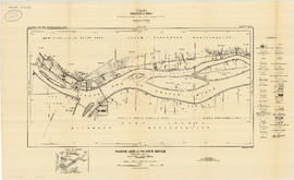
Fraser River - Steveston sheet
Part of City of Vancouver Archives technical and cartographic drawing collection

Part of City of Vancouver Archives technical and cartographic drawing collection

Fraser River - Deas Island sheet
Part of City of Vancouver Archives technical and cartographic drawing collection

Fraser River - Tilbury Island sheet
Part of City of Vancouver Archives technical and cartographic drawing collection

Fraser River - Annacis Island sheet
Part of City of Vancouver Archives technical and cartographic drawing collection

Fraser River - New Westminster sheet
Part of City of Vancouver Archives technical and cartographic drawing collection

Fraser River - Port Mann sheet
Part of City of Vancouver Archives technical and cartographic drawing collection

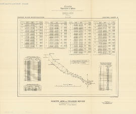
North Arm of Fraser River - Poplar Island sheet
Part of City of Vancouver Archives technical and cartographic drawing collection
North Arm of Fraser River - Boundary Road sheet
Part of City of Vancouver Archives technical and cartographic drawing collection
North Arm of Fraser River - Marpole sheet
Part of City of Vancouver Archives technical and cartographic drawing collection

North Arm of Fraser River - Ione Island sheet
Part of City of Vancouver Archives technical and cartographic drawing collection

North Arm of Fraser River - Point Grey sheet
Part of City of Vancouver Archives technical and cartographic drawing collection

Burrard Inlet - Vancouver sheet
Part of City of Vancouver Archives technical and cartographic drawing collection

Burrard Inlet - Second Narrows sheet
Part of City of Vancouver Archives technical and cartographic drawing collection

Burrard Inlet - Dollarton sheet
Part of City of Vancouver Archives technical and cartographic drawing collection

Part of City of Vancouver Archives technical and cartographic drawing collection

Burrard Inlet - Port Moody sheet
Part of City of Vancouver Archives technical and cartographic drawing collection

Fraser River - triangulation control
Part of City of Vancouver Archives technical and cartographic drawing collection
North Arm of Fraser River - triangulation control
Part of City of Vancouver Archives technical and cartographic drawing collection

Burrard Inlet - triangulation control
Part of City of Vancouver Archives technical and cartographic drawing collection

Map of the municipalities of New Westminster, British Columbia
Part of City of Vancouver Archives technical and cartographic drawing collection
Part consists of the map component of a pamphlet. The map shows the location of churches, school, canaries, sawmills, backyards, tanneries, woolen mills, hatcheries, roads, and railways on a map which depicts the area of Greater Vancouver from the Gulf of Georgia east to Harrison Lake and south to the United States border.

Information concerning the City and District of New Westminster and the Province of British Columbia
Part of City of Vancouver Archives technical and cartographic drawing collection
Part is the text side of a pamphlet. This part contains information concerning the city and district of New Westminster, with individual panels on the municipalities of Delta, Chilliwhack [sic], Surrey, Langley, and Delta, and the City of New Westminster, the town of Harrison Hot Springs and the province.

Map of Vancouver, B.C. including Hastings Townsite and D.L. 301
Part of City of Vancouver Archives technical and cartographic drawing collection

Part of City of Vancouver Archives technical and cartographic drawing collection

Part of City of Vancouver Archives technical and cartographic drawing collection
Part is the front sheet of an unfolded tourism brochure showing Vancouver tourist attractions, The sheet includes a map of downtown Vancouver, with transportation information, a map of the roads in Stanley Park, photographs and information on various sites and attractions in the city, as well as general promotional information.

Part of City of Vancouver Archives technical and cartographic drawing collection
Part is the reverse side of a tourism brochure, containing a tourist map of Greater Vancouver, showing major roads, locations of tourist attractions and recreational sites, and routes into Vancouver.
Part of City of Vancouver Archives technical and cartographic drawing collection
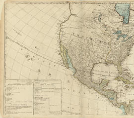
Part is the top left hand quadrant of a map of the Americas, and depicts North America and the north-west portion of South America. The sheet also includes a list of territories and islands in North America and appears to relate to territorial divisions as a result of the Treaty of Paris and the Treaty of Versailles (1783).
Part of City of Vancouver Archives technical and cartographic drawing collection
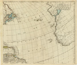
Part is the top right portion of a map of the Americas, and depicts the north-eastern portion of the Canadian coast, the eastern portion of the West Indies, the north-east corner of South America and the coastal areas of south-west Europe and wesern Africa.

Map of Vancouver, British Columbia
Part of City of Vancouver Archives technical and cartographic drawing collection
Part is a map showing Vancouver city streets, electric railways, bus lines, city districts and indicating city boundaries with a shaded red line. Concentric circles spaced one mile apart emanate from City Hall's location on the map.

Part of City of Vancouver Archives technical and cartographic drawing collection

Indexed guide map of the city of Vancouver and suburbs
Part of City of Vancouver Archives technical and cartographic drawing collection
Part is a map showing district lots, blocks, and boundaries between the City of Vancouver, Point Grey, South Vancouver, Burnaby, New Westminster, and parts of Richmond, North Vancouver and West Vancouver. Concentric circles indicate the distance in miles from the intersection of Main Street and Hastings Street in intervals of 1/2 mile.

Indexed guide map of the city of Vancouver and suburbs : map booklet front cover
Part of City of Vancouver Archives technical and cartographic drawing collection

Part of City of Vancouver Archives technical and cartographic drawing collection
Part is a page from the booklet accompanying a guide map of Greater Vancouver, and contains a list of hotels in Vancouver.

District lot index and street index (1st Avenue to Campbell Avenue)
Part of City of Vancouver Archives technical and cartographic drawing collection
Part contains two pages from the booklet accompanying a guide map of Greater Vancouver.

Street index (Campbell Street to Rosser Avenue)
Part of City of Vancouver Archives technical and cartographic drawing collection
Part contains two pages from the booklet accompanying a guide map of Greater Vancouver.

Street index (Royal Oak Avenue, Vancouver to Frederick Road, North Vancouver)
Part of City of Vancouver Archives technical and cartographic drawing collection
Part contains two pages from the booklet accompanying a guide map of Greater Vancouver. Pages include the last portion of the Vancouver and Burnaby street index, the New Westminster street index, and the North Vancouver street index from 1st Street to Frederick Road.

Street index (Gibson Street to William Street) and tram stations
Part of City of Vancouver Archives technical and cartographic drawing collection
Part is a page from the booklet accompanying a guide map of Greater Vancouver, and contains the last portion of the North Vancouver street index, the West Vancouver street index, and a list of Vancouver tram stations.
Indexed guide map of the city of Vancouver and suburbs : map booklet back cover
Part of City of Vancouver Archives technical and cartographic drawing collection

Vest pocket map of Vancouver : map A
Part of City of Vancouver Archives technical and cartographic drawing collection
Part contains a key plan for the larger maps, textual information about Vancouver, and a map of the West End and downtown Vancouver.

Vest pocket map of Vancouver : map B
Part of City of Vancouver Archives technical and cartographic drawing collection
Part shows Vancouver from Westminster Avenue (Main Street) to Garden Drive and Burrard Inlet to Grant Street. Shows district lot and block numbers, public schools, and hospitals.

Vest pocket map of Vancouver : map C
Part of City of Vancouver Archives technical and cartographic drawing collection
Part shows Vancouver from Boundary Street (Alma Street) to Heather Street and English Bay/False Creek to Sixteenth Avenue west of Boundary Street (Trafalgar Street) and to Ninth Avenue (Broadway) east of Vine Street. Shows district lot and block numbers, public schools, and hospitals.

Vest pocket map of Vancouver : map D
Part of City of Vancouver Archives technical and cartographic drawing collection
Part shows Vancouver from Heather Street to Garden Drive and Grant Street to Sixteenth Avenue. Shows district lot and block numbers, public schools, and hospitals.

Vest pocket map of Vancouver : map cover
Part of City of Vancouver Archives technical and cartographic drawing collection

Part of City of Vancouver Archives technical and cartographic drawing collection
Part is a map showing Vancouver including Point Grey, Hastings Townsite, and part of South Vancouver. Map shows streets, street car routes, neighbourhoods, and distances from City Hall.

What the man who comes to Vancouver wants to know
Part of City of Vancouver Archives technical and cartographic drawing collection
Part contains information on lodging, restaurants, transit, social clubs, and other points of interest in Vancouver.

Dial map of Greater Vancouver and suburbs
Part of City of Vancouver Archives technical and cartographic drawing collection
Part contains a street map of Vancouver, Burnaby, New Westminster, West Vancouver, and North Vancouver showing railways, hospitals, parks and block numbers. The map includes two dials (numbered circles, paper indicators, a grid of block numbers and a street index used to find locations).

Part of City of Vancouver Archives technical and cartographic drawing collection
Part consists of a map showing major roadways in the Lower Mainland and the Fraser Valley from Vancouver to Chilliwack, and lists of Vancouver businesses, schools, public buildings, hospitals, bathing beaches, fire halls, and golf and country clubs. Part includes text advertising the products and services of the Dominion Map and Blueprint Company.

Part of City of Vancouver Archives technical and cartographic drawing collection
Part contains a street map of Vancouver showing streets, block numbers, bus routes, railway lines, boundaries, private roads and hospitals. The map includes a dial (a numbered circle, a paper indicator, a grid of block numbers and a street index used to find locations in Vancouver). A small inset shows the streets surrounding Queen Elizabeth Park, which are obscured on the main map where the indicator is attached.

Map of Burnaby and New Westminster, British Columbia
Part of City of Vancouver Archives technical and cartographic drawing collection
Part consists of a street map of Burnaby and New Westminster, information on bus and street car routes, and text advertising the products and services of the Dominion Map and Blueprint Company.