![Inner harbour [showing] small boats and Union Steamship's "Camosun"](/uploads/r/null/8/3/8303cd242ec78fef75e71bafde482f07bd2b430499cc36c71ed69464e42db9b8/44299432-4d2b-4077-a737-f3e87866a9e9-A76340_142.jpg)
Inner harbour [showing] small boats and Union Steamship's "Camosun"
- AM640-S1-: CVA 260-62
- Item
- [ca. 1928]
Part of James Crookall fonds
462 results with digital objects Show results with digital objects
Inner harbour [showing] small boats and Union Steamship's "Camosun"
Part of James Crookall fonds

Royal Navy vessel entering Burrard Inlet
Part of Stuart Thomson fonds

Visit of H.M.S Durbain, Despatch, and H.M.C.S Vancouver
Part of Stuart Thomson fonds

The Harbour Mouth from Common, Looe
This postcard includes personal correspondence addressed to Edwin Baggs of Vancouver.
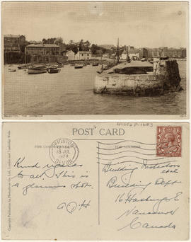
This postcard includes personal correspondence addressed to Building Inspectors, Building Dept. of Vancouver.

Part of Stuart Thomson fonds
![Vancouver Rowing Club [4 man crew on Coal Harbour, arena in background]](/uploads/r/null/9/3/935840dc4b6c8c35b8b892893f6258a14f1cf901a02acf4940f39acfa1849aaa/04258287-c4b5-454c-b01b-694fac748a20-A00426_142.jpg)
Vancouver Rowing Club [4 man crew on Coal Harbour, arena in background]
Part of Stuart Thomson fonds
![Vancouver Rowing Club [8 man crew on Coal Harbour with Stanley Park causeway in background]](/uploads/r/null/0/b/0b7cbc84696c537aae2ba9f958eb8f0d59b6af742fd832bb028e3e708458a461/e95d446c-68ec-444d-ae9a-95215c3787db-A00424_142.jpg)
Vancouver Rowing Club [8 man crew on Coal Harbour with Stanley Park causeway in background]
Part of Stuart Thomson fonds

Part of Stuart Thomson fonds
![Vancouver Rowing Club [Coal Harbour]](/uploads/r/null/7/2/72125a89904efbe46798a712d9d09356026200f774557a0277e8d97653a04376/31cf9fa9-fd92-46a8-89f4-dcf085e71d3d-A00425_142.jpg)
Vancouver Rowing Club [Coal Harbour]
Part of Stuart Thomson fonds
!["Empress of Canada" [entering Burrard Inlet]](/uploads/r/null/9/4/94db9b96ed1cf51e6d7cc1d562628787707c23a528f090ccf8ee512396aed7a9/98f3b35c-e49f-42fa-a34d-9eb96318eda1-A00283_142.jpg)
"Empress of Canada" [entering Burrard Inlet]
Part of Stuart Thomson fonds
!["Empress of Canada" [entering Burrard Inlet]](/uploads/r/null/e/a/ea0c5910328c32658de02132a7a00d337a0995e4661e1e0c691882bef81b2912/7ef44123-7779-4370-abde-3644353aedd5-A00284_142.jpg)
"Empress of Canada" [entering Burrard Inlet]
Part of Stuart Thomson fonds
![[Aerial view looking east over Stanley Park, Coal Harbour and Burrard Inlet]](/uploads/r/null/d/0/d02fee694c486ac2accdeefb505d0dae5fcb42789ef16de49322d845e3c04b44/be8c34ce-7c09-4c0e-a395-f083c9134080-A43248_142.jpg)
[Aerial view looking east over Stanley Park, Coal Harbour and Burrard Inlet]
Part of Major Matthews collection
Oblique view
![Plan showing suggested development fronting D.L. [District Lot] 274, North Vancouver](/uploads/r/null/1/e/4/1e43e8f9bca67073ae3aeaf7041d567d42e6a95a29358355f1cd94909f486f68/d9652aca-fa6d-42c1-880a-e230a325dda4-MAP589_142.jpg)
Plan showing suggested development fronting D.L. [District Lot] 274, North Vancouver
Item is a map showing contours above and soundings below the low water mark along a portion of the North Vancouver shoreline. Map has been annotated with what appears to be the outline of a possible development on the waterfront.
![West Coast trip [with Sherwood Lett, Arthur Lord, W.O. Banfield] : Victoria Harbor](/uploads/r/null/1/a/e/1aeb4a3bc33b7d8193df08812fdb554308428cb72e2c2037cb92b54e2c4ab46b/4e8dd226-9d82-4de4-9fe8-fabe4622f1f9-CVA289-003_142.jpg)
West Coast trip [with Sherwood Lett, Arthur Lord, W.O. Banfield] : Victoria Harbor
Part of William Orson Banfield fonds
![Coal Harbour [showing] Deadman's Island and Stanley Park](/uploads/r/null/d/6/d6ce3aeb165a91b522ef077ca8156f7e3a8ab8b628022e341045a857c0742bbc/b376f1e6-bd3a-4ad5-92c6-958dc0d2db65-A09656_142.jpg)
Coal Harbour [showing] Deadman's Island and Stanley Park
Part of Major Matthews collection
![[Northwest view of Vancouver from Dunsmuir and Hornby Streets]](/uploads/r/null/8/8/88e94ad7604ed40fb7780d502fd141151ebddd9bddf50fa36b4b55a7abda9b58/e8c12a8c-3224-4083-b222-e4b83a4a6952-A65789_142.jpg)
[Northwest view of Vancouver from Dunsmuir and Hornby Streets]
Part of Major Matthews collection
Panoramic view shows Deadman's Island, Brockton Point, Vancouver Rowing Club, Immigration building, C.P.R. Pier A, Y.W.C.A. Building, B.P.O.E. Clubrooms and the Metropolitan building.
![[View of Coal Harbour looking west from the foot of Broughton Street]](/uploads/r/null/9/3/938ee0983c20bbbe94d9286541d172633e29b57b47a906f60e6e43fc2d15dda0/0fd8b222-d407-4f8f-a363-f7b88343cbe3-A08809_142.jpg)
[View of Coal Harbour looking west from the foot of Broughton Street]
Part of Major Matthews collection
Photograph shows the C.P.R. tracks, Pacific Coast Lumber Company buildings and log booms and the Arena on Denman Street. J.S. Matthews' notes with print or negative in Archives.
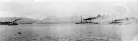
Japanese Warships on visit to Vancouver B.C. Feb. 6-12/1925
Part of Major Matthews collection
Panoramic view showing Coal Harbour, the North Shore Mountains and three warships identified as Asama, Idzumo and Yakumo
![[View of] Coal Harbour and Stanley Park from Georgia [Street]](/uploads/r/null/8/c/8c0a3b0f859c1a378c1463bc15fea75d46976a8289b6c84fcabef3840f06a3b3/490e919d-235c-4eb3-8693-3641e4b6285c-A09696_142.jpg)
[View of] Coal Harbour and Stanley Park from Georgia [Street]
Part of Major Matthews collection
Photograph shows floating shacks and houses, boats and construction materials in Coal Harbour across from Stanley Park.
Part of Stuart Thomson fonds
![[Coal Harbour and Downtown from the Causeway]](/uploads/r/null/d/f/5/df5783e376ce091eaa747d85bdac39ab081c295ffb29db71e675d1326a870c77/8b685d69-96da-4273-b4c4-226e0f99cfc5-CVA260-1224_142.jpg)
[Coal Harbour and Downtown from the Causeway]
Part of James Crookall fonds
Part of Stuart Thomson fonds
![[Boats at anchor in island harbour]](/uploads/r/null/2/6/262e645a55bba35432f103ba74274d794b9e4719d5af2c4da74ef4ab47a0a480/f751b479-05ba-4cb3-86fb-412bd9ad655c-A16054_142.jpg)
[Boats at anchor in island harbour]
Part of Stuart Thomson fonds

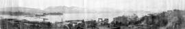
Panoramic view showing Burrard Inlet including 42 ocean steamers in port of which 25 were for grain cargoes, 17 vessels at berth (not shown in photograph) and the Harbour Commissioners wharf and Grain Elevator No. 1 and log booms
![[H.M.S. "Hood" entering Vancouver harbour]](/uploads/r/null/e/d/ed6b149408cd79a855509180daeef8562061c5530236a7d8f47a381c737754f9/84854d81-dd50-4c30-877f-ddfc9f56923c-A16026_142.jpg)
[H.M.S. "Hood" entering Vancouver harbour]
Part of Stuart Thomson fonds
![[H.M.S. "Repulse" entering harbour]](/uploads/r/null/f/c/fc6ca0739f2c54226518db2066ac59f37de70f78f9b849cc1a1e85697b8719e4/b4ee5835-6b3b-4592-80f6-8579b4a28de6-A16028_142.jpg)
[H.M.S. "Repulse" entering harbour]
Part of Stuart Thomson fonds
![[CPR steamships at dock and under sail]](/uploads/r/null/e/6/e6220a75a37e187c4130f03475ed21e9839e7f638daf714d1d0b3ec7491856bf/f14187fa-8e7f-4b23-933c-8c8697388a39-A49459_142.jpg)
[CPR steamships at dock and under sail]
Part of H.A. Price collection
Photograph shows one CPR steamship moored at the east side of Pier "D" while another steams out of Vancouver Harbour.

Part of Stuart Thomson fonds
![[Grain ships in Vancouver Harbour waiting to load grain]](/uploads/r/null/9/f/9f2d3f3a11fa665d2b9686746811b28a10898db2c7b0a189df714e3350a4e788/740c3740-7ce9-4588-aaef-b05f1037283a-A08765_142.jpg)
[Grain ships in Vancouver Harbour waiting to load grain]
Part of Major Matthews collection
Photograph is left section of a three-part panorama (Bo N161.2, Bo P442.1 and Bo P442.3).
![[Bowen Lodge viewed from harbour]](/uploads/r/null/f/4/f4870e098d1b1bb9ef2544df5c113bed17824caf3a0ccb4736743bec67d65a04/3c930c6c-3285-43d7-95ac-67ed6c69d07e-A16128_142.jpg)
[Bowen Lodge viewed from harbour]
Part of Stuart Thomson fonds

Bowen Lodge viewed from harbour
Part of Stuart Thomson fonds

H.M.A.S. "Adelaide" stern view
Part of Stuart Thomson fonds

Part of Major Matthews collection
Panoramic view showing Burrard Inlet including 42 ocean steamers in port of which 25 were for grain cargoes, 17 vessels at berth (not shown in photograph) and the Harbour Commissioners wharf and Grain Elevator No. 1 and log booms
![HMS Hood at Vancouver [British warship in Vancouver Harbour on its Empire Tour]](/uploads/r/null/0/3/030e660a230121de6197a93d162bbe32e3b023da133be31d865d1ce8acf4208f/268a806f-d8cb-480f-b1ea-b7c75162b339-A49461_142.jpg)
HMS Hood at Vancouver [British warship in Vancouver Harbour on its Empire Tour]
Part of H.A. Price collection
Photograph shows HMS Hood at anchor in Vancouver Harbour. Vancouver was a port-of-call on the Hood's round-the-world Empire Tour.
![HMS Hood at Vancouver Liberty boat [Naval steam launch in Vancouver Harbour with passengers]](/uploads/r/null/e/6/e6d94ae19fe180c707b514e7e79d508c51794590f6e43392beed4b11c24678a9/26a69a5a-3181-4689-b3d0-dca774903bdd-A49462_142.jpg)
HMS Hood at Vancouver Liberty boat [Naval steam launch in Vancouver Harbour with passengers]
Part of H.A. Price collection
Photograph shows naval steam launch with civilian passengers in Vancouver Harbour.
![View of ships in harbour [and docks and tracks]](/uploads/r/null/7/8/78e892a7a5987f84f3592b809c8131cb0defbfc6010483c78e9e826ed427c3d7/72d2f4f6-bf06-45c0-b07e-4a38693211c9-A17067_142.jpg)
View of ships in harbour [and docks and tracks]
Part of Stuart Thomson fonds
Photograph shows log booms.
![[H.M.S. "Hood" starboard stern quarter view - entering harbour]](/uploads/r/null/5/5/55e99a9296d9c275bbc4443d7a6d261a59588ace6c454bc0a74a38b2a95ccddd/c34e48ca-fd69-49ba-9389-3fba558fe6a9-A16027_142.jpg)
[H.M.S. "Hood" starboard stern quarter view - entering harbour]
Part of Stuart Thomson fonds

The visit of the fleet : H.M.S. Repulse in the harbor
Part of William Orson Banfield fonds
![[View of the harbour, C.P.R. Pier 'D' and railroad yard from the roof of the Post Office]](/uploads/r/null/e/4/e403caef05acedfc9e78203f7cac185e22853ec36a357deb2f1e3cbb517c0f44/0ce56549-03f9-4349-9a5e-267ba26928df-A09879_142.jpg)
[View of the harbour, C.P.R. Pier 'D' and railroad yard from the roof of the Post Office]
Part of Major Matthews collection
![Vancouver harbour from the roof garden [of David] Spencer's [Department] Store](/uploads/r/null/d/b/db5a883c9aac8bed679b57c2205d549efa86b2a28446fb64721146f1befa6a70/d5e169c6-2878-4aa0-ae91-fea056b71eac-CVA258-8_142.jpg)
Vancouver harbour from the roof garden [of David] Spencer's [Department] Store
Part of Hubert William Lovell fonds
Pier D, Empress of Russia, Deadman's Island and Brockton Point are visible in the distance. Photograph was taken in the summer.

Part of Hubert William Lovell fonds
Photograph was taken in the summer.
![[View of Vancouver Harbour and waterfront looking north]](/uploads/r/null/8/a/8ac88e032f61ec518dc9db5cf599c0aba57a3464e9ef196b0e9d7f900c5a4592/31479d67-42ce-4888-afbf-eb5e079d5850-A60955_142.jpg)
[View of Vancouver Harbour and waterfront looking north]
Part of John William Freeston fonds
Panoramic view showing Burrard Inlet, the Immigration Building, The "Edmore" at C.P.R. Pier A, C.P.R. Pier D, Pier B-C construction site and the Vancouver Riowing Club, Deadmans Island, Coal Harbour, Brockton Point and the Lions in the background
![[View of the harbour, C.P.R. Pier 'D' and railroad yard from the roof of the Post Office]](/uploads/r/null/0/0/0017cc41004f72fbc45775cf71b997df93d9562b9877c14a78d5a30c67506a85/99ef2020-d62e-4cd3-b0b2-d2a012ec9e1f-A09878_142.jpg)
[View of the harbour, C.P.R. Pier 'D' and railroad yard from the roof of the Post Office]
Part of Major Matthews collection

The rum-runner 'Trucilla' enters Vancouver Harbour

Plan of the City of Vancouver, B.C.
Part of City of Vancouver Archives technical and cartographic drawing collection
Item is a map of the old City of Vancouver south to 16th Avenue. The map depicts District Lots and blocks, railway lines, street car lines, industrial areas, parks, postal information, schools, property boundaries.
Part of John William Freeston fonds
Panoramic view showing fuel oil tanks at the foot of Bute Street, Coal Harbour, the Vancouver Rowing Club, Deadmans Island, Brockton Point, the C.P.R. freight car ferry dock, the Immigration building, C.P.R. Pier A and Pender Street west of Burrard Street

View of Vancouver Harbour from Tower Building
Part of John William Freeston fonds
Panoramic view from taken from on top of the Tower building at 500 Beatty street looking northwest and northeast showing such sites as the Universal Knitting Company, the Bank of Hamiltion, Spencers Department Store, the Dominion Building, the Leckie Boot Company, Woodwards water tower, Orpheum Theatre, Pantages Hotel, McLennan and McFeely Co., Pier D, the Union Steam Ship dock and the wharves east and Brockton Point and Burrard Inlet in the background. Photograph also shows various billboards and painted advertisements such as Britannia Beer.

Part of Hubert William Lovell fonds
Photograph was taken in the summer.

Eagle Harbour, old logging buildings
Part of Hubert William Lovell fonds
Photograph was taken in the summer.