![[H.K. Wright fishing in Princess Louisa Inlet]](/uploads/r/null/d/2/d26ab67b1239cd7f701f9a8b66711ec31c240d384a58abb72a2d4b13396c593a/a592ee4f-4438-4bb4-a892-5a72156c43c2-A20543_142.jpg)
[H.K. Wright fishing in Princess Louisa Inlet]
- AM1584-: CVA 7-236
- Item
- [ca. 1911]
Part of James Luke Quiney fonds
990 results with digital objects Show results with digital objects
[H.K. Wright fishing in Princess Louisa Inlet]
Part of James Luke Quiney fonds
Photographs of travel in North America
Part of James Luke Quiney fonds
File contains photographs of the Quiney travels across North America. Includes views of Seattle, Toronto, Niagara, Buffalo, New York, the St. Lawrence River and the Canadian prairies.
![Niagara [River]](/uploads/r/null/c/a/cad69c8621d6a832800e61b217d0cec272195844f692d8c769548950de00ee3b/3ac2f72c-00db-41f7-b08b-23bf174d4eba-CVA7-334_142.jpg)
Part of James Luke Quiney fonds
![St. Lawrence [River at] Brockville](/uploads/r/null/5/5/55e5167f0f4b1bfe85ef1afe970e9d8b50990308edeb25ea79d174af54c89f09/bec21a0c-b66a-4dc5-bcdb-ead38b900109-CVA7-332_142.jpg)
St. Lawrence [River at] Brockville
Part of James Luke Quiney fonds
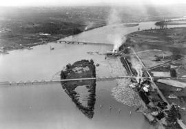
Bridges over Fraser River at Eburne
Part of Stuart Thomson fonds
Oblique view showing the Marpole (Eburne) Low Level Rail Bridge and the Marpole Low Level Highway Bridge from Sea Island and Duck Island
![Capilano Crushing Co., plant #1, 606 Marine Dr., West Vancouver [B.C.]](/uploads/r/null/a/2/a24d60a532d51057c73f925f7d25327890965a448e9b88b4764e0f304b1b7a6f/5eeff546-5586-4d75-aa6f-ea44dac14889-A38720_142.jpg)
Capilano Crushing Co., plant #1, 606 Marine Dr., West Vancouver [B.C.]
Aerial photograph of the mouth of the Capilano river showing gravel quarry site. Some features have been marked on the photograph, with corresponding annotations on the back

Part of Stuart Thomson fonds

Part of Stuart Thomson fonds

Part of Stuart Thomson fonds

Part of Stuart Thomson fonds

Part of Stuart Thomson fonds

Part of Stuart Thomson fonds

Part of Stuart Thomson fonds
![[Creek near] C.J. Piper's cottage [on] Piper [Avenue] south of G.N.R. track North Burnaby](/uploads/r/null/b/0/b07a3a285c36eeb39d1a022d09cfd4079ebdb5c56421cae66bda8e85b95e3c9f/f1ccade7-c066-4825-84be-c0de420f1c9e-A46623_142.jpg)
[Creek near] C.J. Piper's cottage [on] Piper [Avenue] south of G.N.R. track North Burnaby
Part of Major Matthews collection
![[People on bridge over the Fraser River]](/uploads/r/null/b/2/b2fc435947c0667755df8765e8d8f65230d6d7e86955fafe6f7539bb77d6dd94/efe36ba4-3c1a-4dd6-b6c2-caf6d3331feb-A03879_142.jpg)
[People on bridge over the Fraser River]
![[Grader under a bridge on the Fraser River]](/uploads/r/null/9/8/98eb6fca438deeee26741cdc5e0dce23662a4dec4badaded9dd0e1364ae06fdf/5eb4c9bf-29e3-4edc-b6fa-d95c262339a6-A03878_142.jpg)
[Grader under a bridge on the Fraser River]
![[Girl standing on rocks, below bridge on the Fraser River]](/uploads/r/null/3/b/3b577c7b026073fceacf9a33802b96557aff043ad60bb820b898dc0007005e93/2da68f37-7b0f-4793-9dd6-9ee8eb54d846-A03877_142.jpg)
[Girl standing on rocks, below bridge on the Fraser River]

Photograph shows stream, trees and bridge over stream.

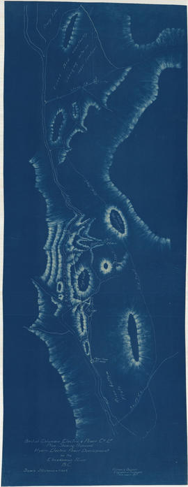
Hydro electric surveys. Preliminary plan of Brandywine Creek
Part of City of Vancouver fonds
Item is a map which shows the results of a survey of the hydro-electric capacity of a section of Brandywine Creek, a tributary of the Cheakamus River north of Squamish, B.C. (D.L. 4098 and D.L. 4100]. The map depicts elevations, creek beds, gravel bars, flat areas, waterfalls, benches, wagon road and the Pacific Great Eastern Railway line. The map includes two cross-section maps of areas A-A and B-B. Notes on the map indicate that the elevations given are the height above the Pacific Ocean, and that Great Eastern Railway datum was used.

Chilliwack Lake scheme & Jones Lake scheme
Part of City of Vancouver fonds
Item is a map depicting proposed hydro-electric development north-west of Chilliwack Lake. The map shows the location so proposed dams, flumes, tunnels and the location of a power house on the Fraser River west of Jones Lake.
Plan shewing proposed hydro-electric power development on the Cheakamus River B.C.
Part of City of Vancouver fonds

Plan of Pemberton valley from District Lot 758 to Lillooet Lake
Part of City of Vancouver fonds

Part of City of Vancouver fonds
Item is an architectural drawing sheet depicting a plan and section of the intake on the Bridge River, and the power house on Seton Lake.

Plan of proposed development of hydro-electric power. Bridge River
Part of City of Vancouver fonds
Item is a map sheet containing a plan and profile of a proposed hydro-electric development tunneling water from the Bridge River to a power plant on Seton Lake. The main map shows the plan of the overall development; the inset map is a Key Plan showing the location of the development within British Columbia.
![General plan [of hydro-electric development on Green River]](/uploads/r/null/d/9/e/d9e4c58e28a2189f0c1819b9c491a0478fad0353e2100858ec1eb94c55b96eae/93fa8e5f-c3b7-4e51-802d-979b7bc07f6f-MAP1098_142.jpg)
General plan [of hydro-electric development on Green River]
Part of City of Vancouver fonds
Item is a sheet containing a map of the proposed development and an elevation of the site, showing the dam, tunnel and powerhouse.
![Plan of fore bay [Nairn Falls hydro electric development]](/uploads/r/null/a/5/5/a55f94fc41cdf02e4a01434daeaf4b6c8715d61bd2a3842a95887e8c7f3371d0/29aba9ea-44a6-4453-9451-4896c8923762-MAP1099_142.jpg)
Plan of fore bay [Nairn Falls hydro electric development]
Part of City of Vancouver fonds
Item is a sheet that contains a map of the location of the dam fore bay, an elevation drawing of the spillway side of the fore bay, 1 section of the fore bay and 2 sections of the fore bay dam.
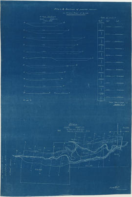
Plan & sections of possible reservoir on Green River
Part of City of Vancouver fonds
Item is a map sheet that depicts a portion of the Green River with a proposed dam site. Twelve cross-sections of the resultant reservoir are depicted, with estimated total cubit feet of water for each in an accompanying table.

Lower Lillooet River - Harrison Lake to Tipella trail
Part of City of Vancouver fonds

Lower Lillooet River - Tipella trail to Bear Lake
Part of City of Vancouver fonds

Lower Lillooet River - Bear Lake to Gowan Creek
Part of City of Vancouver fonds

Lower Lillooet River - Gowan Creek to Rogers Creek
Part of City of Vancouver fonds

Lower Lillooet River - Rogers Creek to Billygoat (29 Mile) Creek
Part of City of Vancouver fonds

Profile 6 Mile Creek from 2+4240 to 3+1990
Part of City of Vancouver fonds

Profiles of sections of Green & Soo Rivers
Part of City of Vancouver fonds

Part of City of Vancouver fonds
Item is a map sheet containing two profiles: one showing the increased reservoir height with a subsidiary dam built and the other a profile of the proposed subsidiary dam site.
Soo River profile from 6+3820 to 9+2380
Part of City of Vancouver fonds

Profile on possible dam sites across Soo River at 2+4340
Part of City of Vancouver fonds

Soo River profile from 9+2380 to 15+1650
Part of City of Vancouver fonds

Soo River profile from Green River junction west 6 miles 3820 ft
Part of City of Vancouver fonds

Proposed hydro electric power development from Brandt, Young, Norton & Hixon Creeks
Part of City of Vancouver fonds
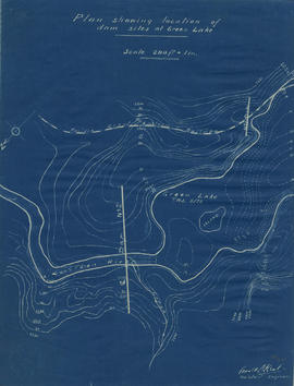
![Longitudinal section along [centre line] of dam sites at north end of Green Lake](/uploads/r/null/7/4/a/74af74789da62d7da66c012dd18dd964e4e83151ac5f0b139a53843bce6ccfe6/974ff05f-0f29-4e65-b818-c663b1a236e1-MAP1142_142.jpg)
Longitudinal section along [centre line] of dam sites at north end of Green Lake
Part of City of Vancouver fonds
Item is a sheet depicting 2 profiles: one of dam no. 1 at railway crossing at 2247+763 and one of dam no. 2 at the head of the Green River (Green Lake).
Plan showing locations of dam sites at Green Lake
Part of City of Vancouver fonds
![Rivers [1 of 3]](/uploads/r/null/8/8/88bfdb2f04e58a973344a89e5e8798f35ffcf5cd9b114555b49482957527fc3d/7efecb0e-07fc-42ff-a91a-083417003c18-A64286_142.jpg)
Part of City of Vancouver fonds
![Rivers [2 of 3]](/uploads/r/null/1/1/112ea7005acea26763c0a65b7cdd5aa53822bc6ca6805830032bc17343033a81/43521d2b-17be-420f-91e4-5f2d57c80c9a-A64287_142.jpg)
Part of City of Vancouver fonds
![Rivers [3 of 3]](/uploads/r/null/2/2/22f9e1f2207335e27d02a704d8cc7f7f40b99734c6065a3261b1f9f743090885/326499ae-df91-47d3-91e5-ea5c1e0327ca-A64288_142.jpg)
Part of City of Vancouver fonds
![South Foot of Gladstone - Fraser River. Pe. [1 of 6]](/uploads/r/null/e/9/e9301ed38f489df2140e46359e84eaa6e5f343c18a7a3b1564b5ec1ebdf27565/95a46084-de34-4a1a-98f3-318e52bb4cac-A66107_142.jpg)
South Foot of Gladstone - Fraser River. Pe. [1 of 6]
Part of City of Vancouver fonds
![South Foot of Gladstone - Fraser River. Pe. [3 of 6]](/uploads/r/null/1/6/1638f456e571ed49d1a72a442d88284427ffba65adfe35fdd612dfeb2085b9dd/868f28ee-bfa4-4b8c-bc4d-14bdf8d5e864-A66109_142.jpg)
South Foot of Gladstone - Fraser River. Pe. [3 of 6]
Part of City of Vancouver fonds
![South Foot of Gladstone - Fraser River. Pe. [2 of 6]](/uploads/r/null/1/8/18ab0dcb4667db381a4fe3432bf81e618ab99ca636681fe662613c88dd2c5678/d79fcf70-2a93-4d54-b48b-bcb2c911c860-A66108_142.jpg)
South Foot of Gladstone - Fraser River. Pe. [2 of 6]
Part of City of Vancouver fonds
![South Foot of Gladstone - Fraser River. Pe. [5 of 6]](/uploads/r/null/b/3/b3f83d66eddcf619f8295aedd235345e4b5db71a48ced9c626f69252ba21d064/e69ff05f-dced-4eaa-8157-14fec3cb3b95-A66111_142.jpg)
South Foot of Gladstone - Fraser River. Pe. [5 of 6]
Part of City of Vancouver fonds
![South Foot of Gladstone - Fraser River. Pe. [4 of 6]](/uploads/r/null/7/f/7f1b88ad2ecb391ca4b36ebc14a93c8c2862ae4ef2cbd2977707fc22311946a1/a0add406-3d1b-4c9e-83dd-c8eb36ff715e-A66110_142.jpg)
South Foot of Gladstone - Fraser River. Pe. [4 of 6]
Part of City of Vancouver fonds