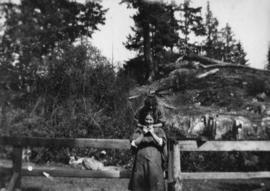
![Lois and Ruth Purdy and two unknowns [in hammock]](/uploads/r/null/1/d/5/1d5d5941bb2749d81dd8488c23b72c6d4c4209a1af6ddb67e5c3d7ec589d29a0/a749766a-85bb-44c5-a7b5-63d9f4462e8d-CVA289-002_142.jpg)
Lois and Ruth Purdy and two unknowns [in hammock]
- AM427-S4-F2-: CVA 289-002.099
- Item
- [ca. 1917]
Part of William Orson Banfield fonds
447 results with digital objects Show results with digital objects
Lois and Ruth Purdy and two unknowns [in hammock]
Part of William Orson Banfield fonds
![Ruth Purdy [sitting on anchor]](/uploads/r/null/f/4/d/f4d6d49b609190ee763be0111b6deed662a4ffb09fbf39831e2292ba096d26b5/ca19f5e0-ae2e-4363-bbba-4ae5dcc052c0-CVA289-002_142.jpg)
Ruth Purdy [sitting on anchor]
Part of William Orson Banfield fonds
![Lois [and friend in hammock]](/uploads/r/null/e/1/4/e14aaa15c4eed71b7b91d11928e937edc1eeb6aff68aa76f100efcd5c58abf0a/6400a2e4-c1bb-49ed-b4c0-274e8cf1d379-CVA289-002_142.jpg)
Part of William Orson Banfield fonds

Part of William Orson Banfield fonds
Item is a photograph showing a group paddling.
![Mae [Nickson] and Lois [and two men]](/uploads/r/null/c/c/2/cc21217347899a234f326138d5ef7cb179cb19f1ca1433a06e96a20ba40cb2ee/fc756ed3-42b7-4a11-ac72-45106731e6a4-CVA289-002_142.jpg)
Mae [Nickson] and Lois [and two men]
Part of William Orson Banfield fonds
![Mae [Nickson] on Cypress Creek](/uploads/r/null/7/1/c/71c29b8c7cab0d107c00cd4fe148de171f3a7d20cf26eefff60f344c219b1be4/3c94e7b8-6d82-411e-968e-e039c50a83ad-CVA289-002_142.jpg)
Mae [Nickson] on Cypress Creek
Part of William Orson Banfield fonds

Part of William Orson Banfield fonds
![Mae [Nickson] in Cypress Creek](/uploads/r/null/1/5/9/159fdca696edc273de741f6b465c787b48434181d4291b3afa121dbc18b0c74d/f712e331-1896-40f4-85e8-191c05b98773-CVA289-002_142.jpg)
Mae [Nickson] in Cypress Creek
Part of William Orson Banfield fonds
![Mae [Nickson]](/uploads/r/null/6/6/f/66f46a665ee24bc8352c2192c7605dfdfc072c1e419ab0e399c26e1f14a6b067/06e3d83d-efff-452a-bfb4-b34f7b617679-CVA289-002_142.jpg)
Part of William Orson Banfield fonds
![Lois [and girl with Colonel, the dog]](/uploads/r/null/5/4/0/5409702b889d23663372346bce9efd333b36f13a8b54bedd84a5ad9c725b1ec5/e9a51505-0098-40ef-98e7-2802f0bbc921-CVA289-002_142.jpg)
Lois [and girl with Colonel, the dog]
Part of William Orson Banfield fonds
![Mae and Ralph [Nickson]](/uploads/r/null/6/6/9/669a7d7deb9330f7c58e9e331d8379d3837bc981cec65ab6e9a5ea2db8ccca9a/890ed465-9809-4cf5-9beb-c1020dc16160-CVA289-002_142.jpg)
Part of William Orson Banfield fonds
Part of William Orson Banfield fonds
![[Girls] in swimming](/uploads/r/null/f/d/f/fdf171ca6c0ca88f91900ff01f79f7b601388cccb63986a7479405186a2decfe/213f8a97-e348-41b0-92fb-6cb493bd5ac8-CVA289-002_142.jpg)
Part of William Orson Banfield fonds
![Lois, Mae [Nickson] and Ruth Purdy on Caufields Dock](/uploads/r/null/a/e/6/ae66be921060db2037071d7f93a26c311dbc180281a32ce9bf03636e7f82adae/2bf57d0e-33de-4f92-a4c7-0ccb881ad4f0-CVA289-002_142.jpg)
Lois, Mae [Nickson] and Ruth Purdy on Caufields Dock
Part of William Orson Banfield fonds
![Mae [Nickson] pensive](/uploads/r/null/9/1/9/919aa606a6b9c6a280067e3185625c4feb1ba1cce305100319e86fc8d55a7576/aac4fa4d-9b47-40a2-b1cc-907dca6f7bef-CVA289-002_142.jpg)
Part of William Orson Banfield fonds
![Mae [Nickson] and Ruth Purdy](/uploads/r/null/b/7/8/b78a5745d57a2810802e892c0088b728fd1c543d06fb047607de478830841838/8ecb1969-f6fa-44d3-b786-6b3179ced809-CVA289-002_142.jpg)
Part of William Orson Banfield fonds

Part of William Orson Banfield fonds

Part of William Orson Banfield fonds

Part of William Orson Banfield fonds

Part of William Orson Banfield fonds
![Mother [Harriet Banfield] and Auntie Bessie at Mr. Henshaws home at Caulfields](/uploads/r/null/9/8/e/98eabbf4b180faae849fa41dc00bdc6a28138aaf61bacc627231f7b44183faad/b44bf21b-564f-4bed-9921-64838b885188-CVA289-002_142.jpg)
Mother [Harriet Banfield] and Auntie Bessie at Mr. Henshaws home at Caulfields
Part of William Orson Banfield fonds
Item is a photograph showing Harriet Banfield and a man sitting on a rock for a portrait.
![Mother [Harriet Banfield] and Auntie Bessie at Mr. Henshaws home at Caulfields](/uploads/r/null/6/8/0/680578d4ffed908c428e5f62260d46e56fa23ccec750b9b59a5d0d582ab8cdf4/42595932-1b30-4d5e-8e18-565bc0fc35ea-CVA289-002_142.jpg)
Mother [Harriet Banfield] and Auntie Bessie at Mr. Henshaws home at Caulfields
Part of William Orson Banfield fonds
Item is a photograph showing a group sitting for a portrait on a rock with a view of the ocean in the background. Harriet Banfield is pictured on the far right.
![Mother [Harriet Banfield] and Auntie Bessie at Mr. Henshaws home at Caulfields](/uploads/r/null/7/3/9/739dc2cb1efb9c63ad891dfe0f61e41ad5132fb4c75da62cd824d5896c539339/37ae6724-af20-46d0-be8a-3c94c0e0e010-CVA289-002_142.jpg)
Mother [Harriet Banfield] and Auntie Bessie at Mr. Henshaws home at Caulfields
Part of William Orson Banfield fonds
Item is a photograph showing a group sitting for a portrait on a rock with a view of the ocean in the background. Harriet Banfield is pictured on the far right.
![Mother [Harriet Banfield] and Auntie Bessie at Mr. Henshaws home at Caulfields](/uploads/r/null/3/e/6/3e67eab116c80f32a4edb4b9b87745fc913e5e32fa35a4f0697e54eb536ee2f8/8f35c66f-341a-42f1-bcc3-81b6dbf991e7-CVA289-002_142.jpg)
Mother [Harriet Banfield] and Auntie Bessie at Mr. Henshaws home at Caulfields
Part of William Orson Banfield fonds
Item is a photograph showing a group having tea. Harriet Banfield is pictured seated on the left.

Part of Karl Koenig fonds
Item is a photograph showing a boat at Gobel's Engine Repair.
![Gobel's [Engine Repair building exterior]](/uploads/r/null/f/5/5/f55e4424c4a51ec72ee5811588c2c04d4e248138d0afb741c01173acfd7df10f/aa9ebcb8-a1d2-4847-931e-90dfb75addce-CVA288-107_142.jpg)
Gobel's [Engine Repair building exterior]
Part of Karl Koenig fonds

Part of Karl Koenig fonds
Item is a photograph showing two men looking at boat under construction.

Part of Karl Koenig fonds
Item is a photograph showing two men looking at boat under construction.

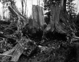
Cypress Creek, West Vancouver, with group of hikers in distance
Part of Samuel H. Logan fonds

Part of Major Matthews collection

Part of Major Matthews collection
The map is a draft of MAP 56.01, "Indian villages and landmarks, Burrard Inlet and English Bay, before the whiteman came." It shows the geographic area bounded by the north shore of Burrard Inlet, the Freaser River, Point Atkinson, and the Burrard Inlet Second Narrows. Shown on the map are locations of First Nations and European settlements, streams, coastal features, and inland vegitation. Physical features are labeled using both First Nations and European place names.

Draft map of Indian villages and landmarks, Burrard Inlet and English Bay, before the whiteman came
Part of Major Matthews collection
The map is a draft of map 56.01, "Indian villages and landmarks, Burrard Inlet and English Bay, before the whiteman came." It shows the geographic area bounded by the north shore of Burrard Inlet, the Fraser River, Point Atkinson, and the Burrard Inlet Second Narrows. Shown on the map are coastal sites labeled with First Nations place names.

Part of Major Matthews collection
Part of Major Matthews collection

Part of Major Matthews collection
Photograph shows a steamboat travelling into the harbour and the Prospect Point signal station and lighthouse in the background

West Vancouver Council members, John Richardson, F.W. Pepper, and Thomas Martin
Part of Pacific Press fonds
Part of Major Matthews collection
Item is a topographical map of the municipalities surrounding Howe Sound and Burrard Inlet. Municipal boundaries, roads and other transportation infrastructure, and radio stations are also included. The Greater Vancouver water supply areas and waterways are shown along with pipe lines, power lines and telegraph lines.
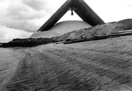
Covered bulk storage of sulphur on the north shore of Burrard Inlet
Part of Vancouver Express fonds

Covered bulk storage of sulphur on the north shore of Burrard Inlet
Part of Vancouver Express fonds

View of Fisherman's Cove taken from highway to Horseshoe Bay
Part of Vancouver Express fonds
Bliss Carman in West Vancouver
Part of Vancouver Poetry Society fonds

Bliss Carman and Dr. Ernest Fewster while on a picnic in West Vancouver
Part of Vancouver Poetry Society fonds

![[Group portrait of a Sea Cadets class at Whytecliffe]](/uploads/r/null/2/7/2707d29a028ed9648467446bc53be097524a35efc6e8855339db0becb7f60a93/2baa9d74-c4df-4834-8977-f92828360880-A11155_142.jpg)
[Group portrait of a Sea Cadets class at Whytecliffe]
![[Group portrait of a Sea Cadets class at Whytecliffe]](/uploads/r/null/6/4/64cd05444e128d6aa6fabb93d64b56a199133846ccc2cec02a046fd32aa05511/94c251a4-1c9c-4c51-99bc-5a38f061c798-A11153_142.jpg)
[Group portrait of a Sea Cadets class at Whytecliffe]

[Group portrait of a Sea Cadets class at Whytecliffe
![[Group portrait of a sea Cadets class at Whytecliffe]](/uploads/r/null/6/0/60f9acca66bd422fe0330a224977207954f0056c7abda6ce5c338f024a124177/ad2729d0-d069-4714-a66b-84199bf68c01-A11151_142.jpg)
[Group portrait of a sea Cadets class at Whytecliffe]
![[Group portrait of a Sea Cadets class at Whytecliffe]](/uploads/r/null/9/9/99903350e2384a4169a2dd4e2487dcd523251b3e3a5ef544233281636dfda849/03bc8c45-3c98-498c-8a03-0b934a1fd8e2-A11150_142.jpg)
[Group portrait of a Sea Cadets class at Whytecliffe]
![[Group portrait of Prince Rupert Division Sea Cadets class at Whytecliffe]](/uploads/r/null/c/e/cec257f70c6c15543ffda61f1286a051f22844a87632950ad50e2f3dd48bab39/8bf5a45d-6a00-440b-b5c6-cbd5141816f8-A11149_142.jpg)
[Group portrait of Prince Rupert Division Sea Cadets class at Whytecliffe]
![[Group portrait of Prince Rupert Division Sea Cadets class at Whytecliffe]](/uploads/r/null/5/d/5d897e6f31f95914a8239bfef67f871e3cdfd14e8e2b603f242ce824c0f5d2bc/2a75103c-df30-4dde-aa3d-9ea1592c6661-A11148_142.jpg)
[Group portrait of Prince Rupert Division Sea Cadets class at Whytecliffe]