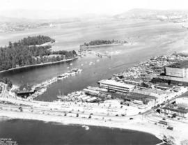
British Columbia - Vancouver skyline
- AM1435-: CVA 1435-13
- Item
- [197-?]
Item is aerial photograph showing part of downtown Vancouver looking north towards Stanley Park and Coal Harbour.
462 results with digital objects Show results with digital objects
British Columbia - Vancouver skyline
Item is aerial photograph showing part of downtown Vancouver looking north towards Stanley Park and Coal Harbour.

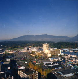
British Columbia - Vancouver skyline
Item is aerial photograph showing downtown Vancouver looking north west towards Stanley Park.

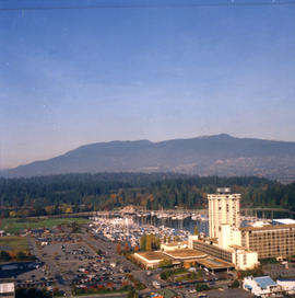
British Columbia - Vancouver skyline
Item is aerial photograph showing downtown Vancouver and Burrard Inlet.

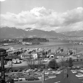
British Columbia - Vancouver skyline
Item is aerial photograph showing Coal Harbour and Burrard Inlet

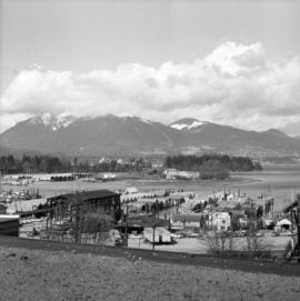
British Columbia - Vancouver skyline
Item is aerial photograph of Coal Harbour and Burrard Inlet.

British Columbia - Vancouver skyline
Item is aerial photograph showing downtown Vancouver looking north west towards Stanley Park.

British Columbia - Vancouver skyline
Item is aerial photograph of downtown Vancouver looking north west towards Stanley Park.

British Columbia - Vancouver skyline
Item is aerial photograph showing downtown Vancouver and Burrard Inlet.

British Columbia - Vancouver skyline
Item is aerial photograph showing Vancouver at night.

British Columbia - Vancouver skyline
Item is photograph showing an aerial view of Burrard Inlet showing the southern shoreline and parts of Stanley Park.
British Columbia - Vancouver skyline
Item is aerial photograph showing downtown Vancouver looking north west towards Stanley Park.

British Columbia - Vancouver skyline
Item is aerial photograph showing Coal Harbour from the south shore.

British Columbia - Vancouver skyline
Item is aerial photograph showing downtown Vancouver looking north west towards Stanley Park.

British Columbia - Vancouver skyline
Item is aerial photograph showing part of downtown Vancouver looking north west towards Stanley Park.

British Columbia - Vancouver skyline
Item is aerial photograph showing Coal Harbour from the south shore.

British Columbia - Vancouver skyline
Item is aerial photograph of downtown Vancouver and Burrard Inlet.

British Columbia - Vancouver skyline
Item is aerial photograph of downtown Vancouver and Burrard Inlet.

British Columbia - Vancouver Skyline
Item is aerial photograph showing downtown Vancouver, Stanley Park, and Burrard Inlet.

British Columbia - Vancouver skyline : Westcoast bldg. and scenery from inside
Item is aerial photograph showing Coal Harbour and Stanley Park.

Item is photograph showing aerial view of Canada Place and other buildings of downtown Vancouver.

Cape Mudge Lighthouse from the Air
Part of Major Matthews collection
Oblique view
Item is photograph showing an aerial view of Stanley Park and Coal Harbour.

Item is photograph showing an aerial view downtown Vancouver looking northwest towards Coal Harbour and Stanley Park.

Item is photograph showing an aerial view downtown Vancouver looking northwest towards Coal Harbour and Stanley Park.
Item is photograph showing an aerial view downtown Vancouver looking northwest towards Coal Harbour and Stanley Park.

Close aerial view of Vancouver City Hall, with Cambie Street and cars
Part of City of Vancouver fonds
Part of Major Matthews collection
Oblique view looking northeast showing the Denman Arena, the Georgia Street entrance to Stanley Park, the Vancouver Rowing Club, Brockton Point and Deadmans Island
![[Collapse of Second Narrows bridge during construction]](/uploads/r/null/7/b/7b1b0ec0cf16f91f2f421656c37e2edaa449477a299e7b2ac3df0109763f7707/a9342f72-46ec-44d5-bf84-fde7dc22a42a-A24446_142.jpg)
[Collapse of Second Narrows bridge during construction]
Part of Major Matthews collection
Oblique view.

Composite aerial mosaic of metropolitan Vancouver
Part of City of Vancouver Archives technical and cartographic drawing collection
Item is a map in the form of a composite aerial photograph showing Greater Vancouver, including West Vancouver, North Vancouver, Vancouver, Burnaby, New Westminster, Port Coquitlam, Coquitlam, Richmond, Delta and Surrey.
![[Eastern view of Vancouver's waterfront]](/uploads/r/null/e/6/e6c8b31b7f9fdcdb39ea15c2f8c416643495406655370ab1b0674baefc887af3/c5f54d6e-fafc-4db5-840f-ee6af9f443ec-A43370_142.jpg)
[Eastern view of Vancouver's waterfront]
Part of Major Matthews collection
Oblique view showing Ballantine Pier, Buckerfields, the Second Narrows (cantilever) Bridge and the North Shore in the background

Expo '86' - press release footage
Part of Yaletown Productions Inc. fonds
Item consists of raw footage featuring B.C./Expo 86 aerials; shot in 35mm and transferred to one inch tape. Original negative no longer exists and only video footage survives. Some of this material was used in Yaletown Production's video postcard series.
![False Creek Construction and Development [16 of 46]](/uploads/r/null/b/7/b7f25fc0ce57359846902658629950abe6516aa23007aa6d7221379c8ca686f3/62e1a447-9428-4078-8c33-246592c8c97e-A66414_142.jpg)
False Creek Construction and Development [16 of 46]
Part of City of Vancouver fonds
![False Creek Construction and Development [29 of 46]](/uploads/r/null/d/8/d8b2bf2de1b32f72b54508607b94dcedd7009fd72d3c2f00a53fb77f58f5b764/4fe12044-b7d7-4a83-b3a0-fbe668b49d7d-A66427_142.jpg)
False Creek Construction and Development [29 of 46]
Part of City of Vancouver fonds
![False Creek Construction and Development [30 of 46]](/uploads/r/null/6/b/6b031ac9ab7b93832c88468a6bed93e9af88daf76f562ebbfb5528fbd97716b4/be48b00a-284e-40da-9df9-cae43a163b18-A66428_142.jpg)
False Creek Construction and Development [30 of 46]
Part of City of Vancouver fonds
![False Creek Construction and Development [31 of 46]](/uploads/r/null/9/2/9205574976d816ba47d939bda896f3fde94e94c8a0f2481dbf912b7a77c24ce7/d7044b05-18e0-4ec3-b11a-31e6b126a974-A66429_142.jpg)
False Creek Construction and Development [31 of 46]
Part of City of Vancouver fonds
![False Creek Construction and Development [32 of 46]](/uploads/r/null/4/b/4b603b6bc6cb92815ca616a42462305634b9f84c5c2e1705caf02a83efccb0ba/bd80820d-2172-4bbd-80bf-c64a0fb2a357-A66430_142.jpg)
False Creek Construction and Development [32 of 46]
Part of City of Vancouver fonds
![False Creek Construction and Development [33 of 46]](/uploads/r/null/0/8/0847c9194674abb075e139a51985f8667203c8557e6200c28593021f7e88c9a1/b662d55e-dfa9-41ac-a66c-8c01c50008a5-A66431_142.jpg)
False Creek Construction and Development [33 of 46]
Part of City of Vancouver fonds
![False Creek Construction and Development [34 of 46]](/uploads/r/null/3/2/325d3cc7927eb0a37268c415423cae1b41ee0beb2d2552166c7551c14723fbc2/93de867a-2f51-44a7-99d2-74ea424568c4-A66432_142.jpg)
False Creek Construction and Development [34 of 46]
Part of City of Vancouver fonds
![Garbage landfill - Old pictures [14 of 31]](/uploads/r/null/f/4/f40eeef962d8de76f02f1c133703296d9fb63530c300417ae08c28c5c8833b54/65308e29-ed50-498c-9967-7f6a2595696a-A66350_142.jpg)
Garbage landfill - Old pictures [14 of 31]
Part of City of Vancouver fonds
![Garbage landfill - Old pictures [15 of 31]](/uploads/r/null/b/f/bf026c4ad6c00d44c4be6cede0e04e2a487501471a0c14c2066b87d3ad8cb618/055d3f5b-3b53-4c73-9d7d-0501d04b2f13-A66351_142.jpg)
Garbage landfill - Old pictures [15 of 31]
Part of City of Vancouver fonds
![Garbage landfill - Old pictures [16 of 31]](/uploads/r/null/6/d/6d54b09f3f17e444eaaeaf1171430396e92538cc2c5102751b4705dbc06674b4/8c0e78af-2237-44d2-98af-5cd010c3daf8-A66352_142.jpg)
Garbage landfill - Old pictures [16 of 31]
Part of City of Vancouver fonds
![Garbage landfill - Old pictures [17 of 31]](/uploads/r/null/b/2/b2a7e5c925bb47f2b66d7a6d618eb39ab16deac7440c2240c8ca5cb1250b6485/147092f2-7408-49c2-8992-a3a848b58183-A66353_142.jpg)
Garbage landfill - Old pictures [17 of 31]
Part of City of Vancouver fonds
![Garbage landfill - Old pictures [18 of 31]](/uploads/r/null/d/0/d040038fed80dd33a6672bf5bc76e322ebf322d702a54c8232f84ad1be4cffa8/5d3d7160-7fd1-4647-a556-72e1814a3292-A66354_142.jpg)
Garbage landfill - Old pictures [18 of 31]
Part of City of Vancouver fonds
![Garbage landfill - Old pictures [19 of 31]](/uploads/r/null/7/3/73a20f15559f5b13ce3bf3c4a62207d63a3768bc34c324024b6dbd6456a746c6/2ef242b7-ba65-4fb3-a10e-b40bc96bdca6-A66355_142.jpg)
Garbage landfill - Old pictures [19 of 31]
Part of City of Vancouver fonds
![Garbage landfill - Old pictures [20 of 31]](/uploads/r/null/7/c/7cc6b2058aa21dddca9e4d4f13e4cfd4ba150bf7c95e5f5cfa2d6f0181a85c43/1dcbef78-c3ae-4895-9b59-ffef580d0d5d-A66356_142.jpg)
Garbage landfill - Old pictures [20 of 31]
Part of City of Vancouver fonds
![Garbage landfill - Old pictures [21 of 31]](/uploads/r/null/f/a/fa41af6b3d1952074bbf76248185156be6015a0b34c8305f91d5a33e6d604768/ee42a0f0-0fa7-4904-aee5-0c69b95f162d-A66357_142.jpg)
Garbage landfill - Old pictures [21 of 31]
Part of City of Vancouver fonds
![Garbage landfill - Old pictures [22 of 31]](/uploads/r/null/1/6/1629ff01fc83ca2f37b4d8155019d21781b81faf842f824ec86a4b63bf59c513/adc7b2b1-1095-485e-8464-6386e49962b5-A66358_142.jpg)
Garbage landfill - Old pictures [22 of 31]
Part of City of Vancouver fonds
![Garbage landfill - Old pictures [23 of 31]](/uploads/r/null/3/2/3268504596e0b7668d8d7b73368411bd0efd26468a9bb6c47bc19f6e5893227a/dfeb33ea-7f30-4c41-ae9e-9ce3cda9d628-A66359_142.jpg)
Garbage landfill - Old pictures [23 of 31]
Part of City of Vancouver fonds
![Garbage landfill - Old pictures [24 of 31]](/uploads/r/null/c/c/cc338661ac851aa511fa08074b44d8d303a43627b21e381fc6d750c38baa0b33/af33bbd4-bc4f-425a-b550-6ceffe96e51c-A66360_142.jpg)
Garbage landfill - Old pictures [24 of 31]
Part of City of Vancouver fonds
![Garbage landfill - Old pictures [25 of 31]](/uploads/r/null/5/0/5077507d68c287c6488b7347abb1565f3bf127721e50d4f0116fca5f5804ce29/6cd10d11-0620-4d4a-9c90-4bf58fe354b3-A66361_142.jpg)
Garbage landfill - Old pictures [25 of 31]
Part of City of Vancouver fonds