- AM54-S4-: Port P1699
- Item
- [188-?]
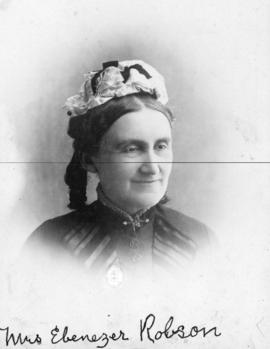
Part of Major Matthews collection
Head and shoulders portrait
68260 results with digital objects Show results with digital objects
Part of Major Matthews collection
Head and shoulders portrait

Part of Major Matthews collection
Photograph shows the Robert Kerr, a C.P.R. coal hulk in the foreground.

On the beach of the Narrows, Vancouver, B.C.
Part of Major Matthews collection
Photograph shows beach and Burrard Inlet, looking north, near Prospect Point. Photograph also shows a man in a rowboat and the ship "Princess Louise". J.S. Matthews' notes with print or negative in Archives.
![[View of English Bay Beach looking south]](/uploads/r/null/5/c/5c6560607f3ab55867d2ec2401b1e4e7a64c7a71526b184e9f56940418207652/2fb56c60-7ebf-42b3-b712-92c7d3bd92b1-A23708_142.jpg)
[View of English Bay Beach looking south]
Part of Major Matthews collection
Photograph shows Frank Murphy's cottage.
![[Mrs. Josephine Sullivan's house - N.W. corner of Gore Avenue and Oppenheimer (E. Cordova) Street]](/uploads/r/null/e/e/eee8b5306e55eb64ef004cc31ea6a353a298c69ed492db700c3eb050e198f910/eef7fc9b-c345-4556-b8dc-5e1a7e90c3bf-A24599_142.jpg)
[Mrs. Josephine Sullivan's house - N.W. corner of Gore Avenue and Oppenheimer (E. Cordova) Street]
Part of Major Matthews collection
Item is a photograph showing the house of the Sullivan family, early Black settlers in Vancouver.
![[Exterior of E.V. Bodwell's real estate office - 301 Cordova Street]](/uploads/r/null/2/4/24b664516cf171eb31dab30691c3c5fc695046fbb910982434c6a2ca94b30c9b/13d67481-046a-4245-b9ed-fe646006db9b-A24725_142.jpg)
[Exterior of E.V. Bodwell's real estate office - 301 Cordova Street]
Part of Major Matthews collection
![[Captain and Mrs. George William Robertson and daughter]](/uploads/r/null/3/b/3bb17cd14fa3931c30207eff08c04c2a5078406b9760185341eb0ce5ed35f798/4c10d88f-616f-40c2-9343-b2df3f21ba5e-A26844_142.jpg)
[Captain and Mrs. George William Robertson and daughter]
Part of Major Matthews collection
![[Interior Vancouver City Foundry and Machine Works]](/uploads/r/null/f/3/f35886f935b5c3fc265682b06b50167c1512b3e09380be734df0f7cad60e808b/9886746e-8f37-415e-b05c-19b5d2710090-A24695_142.jpg)
[Interior Vancouver City Foundry and Machine Works]
Part of Major Matthews collection
![[Group portrait in front of Rand Bros. Real Estate office - 100 Cordova Street]](/uploads/r/null/b/0/b0548d9b9d8baaf804c6b05df02441d853eaa82999b1cd126e280042048cfa40/57f05bb0-add0-4a60-9eb5-00ea72095552-A24692_142.jpg)
[Group portrait in front of Rand Bros. Real Estate office - 100 Cordova Street]
Part of Major Matthews collection
Men identified (left to right): G.L. Fowler, J.D. Byrne, Mr. Leonard, W. Quam, Mr. Hay, D.S. Wallbridge, James England, P.M. Ferris.
![Building [Hotel Vancouver] with horse and carriage in front](/uploads/r/null/5/2/0/52006406f0d5927fac22b91a3787c5a751a59c7b19a31fcf751e93ff3693fe85/809a496f-19e7-4b8d-bfc7-06816e3afdbe-CVA99-1300_142.jpg)
Building [Hotel Vancouver] with horse and carriage in front
Part of Stuart Thomson fonds
Item is a photograph which appears to be a copy of a photographic print of a Hotel Vancouver.

Part of Major Matthews collection
![[Boys' baseball team seated on grass at Cambie Street grounds]](/uploads/r/null/c/6/c654165650c924a8c32a86bfe3d118ad4fa2a7f04f999d73387efa8002999dcd/59886a64-db8c-45ad-b868-262c3c20467e-A03947_142.jpg)
[Boys' baseball team seated on grass at Cambie Street grounds]
Part of Major Matthews collection
J.S. Matthews' notes with print or negative in Archives.
![[Queen Brothers Stanley Park Stables - south side Georgia between Seymour and Granville Streets]](/uploads/r/null/2/7/2754bb55f6751ff8b1069d0c2fd0a07d73f15eb895039e3787cd7a8b6d0f4dd1/5cb5f962-a6f6-466b-b255-232372627b21-A24608_142.jpg)
[Queen Brothers Stanley Park Stables - south side Georgia between Seymour and Granville Streets]
Part of Major Matthews collection
Photograph shows Frank W. Hart's funeral hearse.

Part of Major Matthews collection
![[S.S. "Premier" at C.P.R. wharf]](/uploads/r/null/5/f/5f0594e5553936ef3b8f2b8be560282245c10d7e18d6064279e6daca58ecab5a/b5c97ea9-0843-44a5-853b-4f3a516a7242-A24336_142.jpg)
[S.S. "Premier" at C.P.R. wharf]
Part of Major Matthews collection

City looking east from Georgia and Granville Streets

Str. Premier rounding Brockton Point, Vancouver, B.C.
Part of Major Matthews collection
![[Wreck of S.S. "Beaver" off Observation Point (now Prospect Point)]](/uploads/r/null/8/5/855e9b657b8c1da462e0f4b34e77c4a5dd2c8acc4484ad6ef3a098241251578d/59c6c6f1-5686-4782-8545-eae8f73d1e33-A23846_142.jpg)
[Wreck of S.S. "Beaver" off Observation Point (now Prospect Point)]
Part of Major Matthews collection
![Interior Machine Shops of City Foundry [at the foot of Hawks Avenue]](/uploads/r/null/6/7/67470dc08c6a6a497d75c2e6e88a8283112221bac99344d044782861c2a3469c/725cb70b-7e71-429e-ae53-8655e31eccb9-A24615_142.jpg)
Interior Machine Shops of City Foundry [at the foot of Hawks Avenue]
Part of Major Matthews collection

Vancouver From Westminster Avenue South
Part of Major Matthews collection
Photograph shows Main Street near 6th Avenue looking north
![[McCleery house, showing people in front yard]](/uploads/r/null/2/1/21348ac829e2cc5c961666334965b512da760d1e4cabbdf8c1ca2f1c046bc483/08920345-aa2a-4529-90f6-f59c02acca67-A02178_142.jpg)
[McCleery house, showing people in front yard]
Photograph shows the house, surrounded by trees, and various men, women, and children in the front yard.

(Main St.) West Westminster Avenue, Vancouver
Photograph shows incomplete plank roads, a brick building in the foreground, and various other buildings in the background.
![[Exterior of Barker and Mackay Real Estate and Diplock and Osburn Importers at 519 Hastings Street]](/uploads/r/null/7/2/72f1e8d815ab3ffb75d3b8e36af0d86b9a0c3958eafaf93ce8b9839f79d5cacf/624e8157-f95e-4c5c-88fe-22fe4d03a4d0-A37013_142.jpg)
[Exterior of Barker and Mackay Real Estate and Diplock and Osburn Importers at 519 Hastings Street]
Part of Major Matthews collection
Group portrait showing (left to right): E.E. Barker and his dog "Bruce", Dr. J.M. Lefevre, Mr. Mackay, Mr. C.G. Johnson, Mr. Beasley, Mr. Osburn and Mr. Diplock
![[Exterior of R. Mackay Fripp residence - 1264 Pender Street]](/uploads/r/null/0/8/0820a3044faaa02274a5079686d32c7fc8467d3d65d2ee9d3098a22f4dcc49a6/33ee8883-30e4-4490-bcb7-db783702a7ba-A24710_142.jpg)
[Exterior of R. Mackay Fripp residence - 1264 Pender Street]
Part of Major Matthews collection
Photograph shows Coal Harbour and Deadman's Island.
![[Group of men and boys on Greer's Beach (Kitsilano Beach)]](/uploads/r/null/6/8/68cae060e653db9c1d3b70a57e40fcc26286399fcd471d6c4d5857126433c4ba/b25bc43e-c462-419f-89b1-1cbfdc99f1c8-A23689_142.jpg)
[Group of men and boys on Greer's Beach (Kitsilano Beach)]
Part of Major Matthews collection
Men identified left to right: W.T. Dalton and C.E. Hope. Photograph is a view looking north from about the foot of Whyte Avenue.
![[Group portrait of W. Johnson (far left), H. Stephens, C. Stephens and J. Anderson]](/uploads/r/null/b/7/b71ea85767c523f0a22fa79812276bc711452e515b96e6e5a1118f05f4eb2a80/26ca1620-d106-4919-af29-d3eeb3090b68-A34385_142.jpg)
[Group portrait of W. Johnson (far left), H. Stephens, C. Stephens and J. Anderson]
Part of Major Matthews collection
Studio portrait
![[L.A. Hamilton]](/uploads/r/null/1/8/1800f20b7456d1da34fb1cea62341b799f418dae0fdd0ff8768713b8043da549/d075f430-b3fe-45d4-b58b-26c1aed96267-A34343_142.jpg)
Part of Major Matthews collection
Head and shoulders portrait
![[Looking north from Georgia Street from the Hotel Vancouver]](/uploads/r/null/0/6/068fe03d8f45f3fc51aa86d37db6e46b2d340ec131401540ce8820b4a53f3e9a/fcf47eba-f8dc-43a3-ab61-1a71338fe9d8-A43263_142.jpg)
[Looking north from Georgia Street from the Hotel Vancouver]
Part of Major Matthews collection
Photograph shows the 500 and 600 Blocks of between Howe Street and Granville Street including part of the C.P.R. Park, the Japanese Consul, Manor House under construction, the Van Horne Block and the Bluff showing the homes of A.G. Ferguson and Harry Abbott in the background
![[John McDougall]](/uploads/r/null/8/f/8fd5de7de7ca143ecebd924843f763e29d189dc76859a981462f64161a8d2bd4/8a884f98-f75e-48fc-954c-46af98672ca7-A34993_142.jpg)
Part of Major Matthews collection
Full-length portrait
![[A float in the 400 Block of Powell Street ready to join the Dominion Day parade]](/uploads/r/null/5/b/5b6f69011d9374a0acf2605c2d34f53ae6a18340a689fcec7ac0a9d16fc7f8ea/4501f382-7445-435f-a5a6-0e623aafc27e-A37169_142.jpg)
[A float in the 400 Block of Powell Street ready to join the Dominion Day parade]
Part of Major Matthews collection
Photograph shows Choice Groceries in the background
![[A team of oxen on a skid road in Oben's Camp in the West End]](/uploads/r/null/d/6/d60bffa46dd5270b6b108f58f23dd9fabcd7b25d637b5f77d4fdac1da587267f/4b4b6f37-1973-4edd-bd27-2d096229a9f9-A37320_142.jpg)
[A team of oxen on a skid road in Oben's Camp in the West End]
Part of Major Matthews collection
![[Alderman William Towler's house - 273 Dufferin St.]](/uploads/r/null/7/9/798a3e8e0e5b9c11d3dd7392d4378088007ceae110ee01044a7fa6af33a8ddd4/5d85d5a6-5897-410b-87a9-926c6197eb8a-A24575_142.jpg)
[Alderman William Towler's house - 273 Dufferin St.]
Part of Major Matthews collection

Part of Major Matthews collection
Photograph shows a view loking north from the corner of Westminster Avenue (Main Street) and 7th Avenue including the Westminster Avenue Trestle Bridge and False Creek in the background

Vancouver city foundry and machine works
![[The Ridley family]](/uploads/r/null/9/2/920c4d4b41f49d0a7f39b6ca00b8b2b14b53c04a191df6f1938565fcba7bce77/cf691478-b83f-4005-8df2-688f4e2b93ea-A35362_142.jpg)
Part of Major Matthews collection
Group portrait showing Mr. and Mrs. Abington Herbert Ridley and their sons Leon Alonzo, Harold E. and Oscar E.
![[The street railway wharf at the foot of Westminster Avenue (Main Street)]](/uploads/r/null/e/0/e0653757cba383acb83abe9070d02c64eefd34e400aaa810eb1add8e11df4023/1524e309-241a-4742-9e51-bd94d509ac1b-A37513_142.jpg)
[The street railway wharf at the foot of Westminster Avenue (Main Street)]
Part of Major Matthews collection

Vancouver Iron Works and Foundry
Part of Major Matthews collection
Sign on building reads: Vancouver City Foundry and Machine Works.
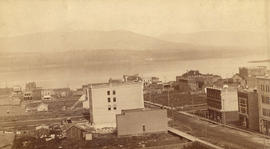
Vancouver, B.C. from the South
Part of Major Matthews collection
Photograph shows a view looking north from the corner of Westminster Avenue (Main Street) and 7th Avenue including the Westminster Avenue Trestle Bridge and False Creek in the background

Vessels in Harbor at Vancouver, B.C. July 1st 1889
Part of Major Matthews collection
Warships identified (left to right) H.M.S. "Swiftsure", "Champion", "Icarus" and the "Amphion" behind
City of Vancouver : Canadian Pacific town site
Part of City of Vancouver Archives technical and cartographic drawing collection
Primary map shows lot numbers and boundaries, streets, fire limits and "soundings in feet" (in English Bay, Burrard Inlet, Coal Harbour and False Creek) in downtown Vancouver, Stanley Park and parts of Kitsilano and Fairview. The ancillary maps show an "Index plan of Vancouver, B.C.", an "Index plan of [Vancouver] city limits" and "Canadian Pacific Mail Steamship Lines" (a map of Canadian Pacifc steamship routes around the world). On recto, the item also includes a description of Stanley Park and an illustration of Vancouver's inner harbour. On verso, the item includes descriptions of major Vancouver residences, imports, exports, businesses and other landmarks.

Part of City of Vancouver Archives technical and cartographic drawing collection
Item is a copy of sections of a November 1889 fire insurance map that have been pieced together. Includes the area between Seymour and Dunlevy Streets, from the south shore of the Burrard Inlet to Keefer Street. Map shows Chinatown, part of False Creek, and buildings and their uses (commercial, residential, industrial). The name of the business, business owner, or type of business is noted for most commercial and industrial buildings.
Looking across the Inlet from Hotel Vancouver
Part of Major Matthews collection
Photograph shows Granville Street looking north
![[Streetcar line construction on Westminster Avenue (Main Street)]](/uploads/r/null/2/e/2e11f1b88aede4c0a2ce506bae1ec7c0a9a7fee2726e6e29c6c23f0c6b448cb1/e5f93bcf-7245-4739-999d-c179ae971e63-A37511_142.jpg)
[Streetcar line construction on Westminster Avenue (Main Street)]
Part of Major Matthews collection
Photograph shows a view looking north from near Prior Street
![Exterior of C.P.R. stables - Water Street (Blk. 9, D.L. 541)]](/uploads/r/null/9/5/9591717c799f7ae242234eb7e51dcc232d38773bdc8f3aebe51cfadbd91600a4/a664867f-0ab8-4989-93e6-970481fb8b3d-A24690_142.jpg)
Exterior of C.P.R. stables - Water Street (Blk. 9, D.L. 541)]
Part of Major Matthews collection
Photograph shows D.B. Charleson's teams, wagons and men. Men identified: in front James Keil and holding mules Ed Warner; Also Jack Kerr, Sid Kerr, Tom Frewer and Alderman Cleland.

Foot of Marine Crescent, Vancouver, B.C.
Photograph shows a man and a woman at the base of a large tree

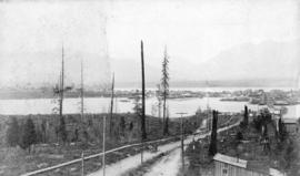
City looking north from Seventh Avenue and Main Street

Embarkation of His Excellency Lord Stanley and Party on S.S. "Premier"
![[North Arm Road (Granville Street) looking south]](/uploads/r/null/0/6/06146ca573f45fb59102abd2b3168cedd6e10e0364161fee86d4085bc2598f22/e12a9179-9a90-4153-a43e-628b48aeb690-A37069_142.jpg)
[North Arm Road (Granville Street) looking south]
Part of Major Matthews collection
![[Interior of City Foundry and Machine works at the foot of Hawks Ave.]](/uploads/r/null/4/6/46d5bc1d45ff3906589c1fbee19fd81238abb648afc1aa2004c185531c231699/2bf364fe-84aa-4b4f-9652-b2b097a03a93-A24616_142.jpg)
[Interior of City Foundry and Machine works at the foot of Hawks Ave.]
Part of Major Matthews collection

Part of Major Matthews collection