Item is a pamphlet with a map on one side and text on the other. The map shows the location of churches, school, canaries, sawmills, backyards, tanneries, woolen mills, hatcheries, roads, and railways on a map which depicts the area of Greater Vancouver from the Gulf of Georgia east to Harrison Lake and south to the United States border. The verso contains information concerning the city and district of New Westminster, with individual panels on the municipalities of Delta, Chilliwhack [sic], Surrey, Langley, and Delta, and the City of New Westminster, the town of Harrison Hot Springs and the province.


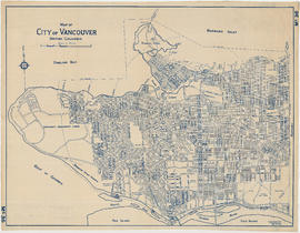
![Map of City of Vancouver [City services locations]](/uploads/r/null/5/7/7/577519f13333b5141f19d58696ae109b192fab0007ff302e15453cab74e21dd3/3a32f9e1-f624-41f7-980d-3b5df4397fb6-MAP225_142.jpg)

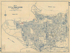


![Map of City of Vancouver, British Columbia [index map]](/uploads/r/null/b/4/b4070d13913e90841a24384f7c94ab9f22595ff9bde62429edb46fd5ed60a75a/f4bb676f-1639-4811-82bf-2a0d4defd87e-MAP779_142.jpg)

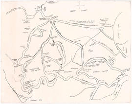


![[Map of Pioneer Place showing the area deeded to the City of Vancouver by the C.P.R.]](/uploads/r/null/4/1/41ba387b96586eb8554abcbf013c0e5cfbb116a42c8d1d1d2311fb1856694b2a/e3bd79d3-cd72-42e4-aa51-bc080514c205-MAP780_142.jpg)


![Map of Stanley Park [site plan]](/uploads/r/null/1/c/1c9f6dc06e0884db9e77fbf60ada5f034a83d9de980993fddeb5e2475c9e2b97/52d1c868-f7bb-48bd-a2e8-0fa3444cfeec-MAP62_142.jpg)
![Map of the business portion of the City of Vancouver, British Columbia [early street paving]](/uploads/r/null/7/1/7187f671d2770050eb87f7f397a10ea92bf0bc593b0a186e3a4bf341b3d26e42/8770145a-b925-4eef-82ac-e397f61a65aa-Map1163_142.jpg)
