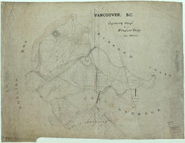
Item is a map sheet containing two maps. The principal map depicts greater Vancouver, including portions of North and West Vancouver, Richmond and Surrey. The information depicted on the map includes streets, postal blocks, streetcar and railway lines, parks and golf courses, and schools. The map includes 1/2 mile distance circles centred on old City Hall at Main and Hastings.
The sheet includes an inset map of Granville Island. Depth of water given along shorelines of Burrard Inlet, English Bay, and along the West Vancouver coast from First Narrows to Howe Sound. The sheet includes an index of streets.


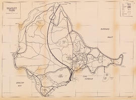
![City of Vancouver [park sites June/80]](/uploads/r/null/9/4/9484add7c4684ea3838e4d00ee8add3ecf85d78d5aa8fe2780cae273e59556a5/bd2464d8-2aa9-4501-aba6-8b3f7d130a42-MAP1032_142.jpg)


![[View of the Great Northern (Union) and Canadian National Stations and Thornton Park]](/uploads/r/null/3/f/3f3bf794ce9c38103d6e1f740d743b90cf54e8f2591d95f7406a69a338615147/b1609fd1-5aca-4ca5-87bc-b899b4c76130-A63485_142.jpg)


![[Two women seated on grass at Beacon Hill Park]](/uploads/r/null/f/8/f84e1af85ff3bb9ba0220c9b3e15df151edc23f5b6359f870c47de8ca577b20b/b1447fb8-8b76-4f5c-a736-88810afbc8c7-A07640_142.jpg)
![[People watching swans in pond at Beacon Hill Park]](/uploads/r/null/3/1/31548fa1753751f5f66d6e282b17f1b21397c362245abdf5e2c7ac9f1ab04a72/0cba3760-0159-4f2e-89c3-937806492534-A07641_142.jpg)
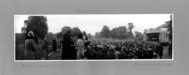

![[Crowds gathered to watch events at Beacon Hill Park]](/uploads/r/null/7/b/7bc5122aae7676fb7d8b545d530f94fe46a3fd6e556784530127b180362a6cb3/b0bc635d-eab8-4240-a391-cff0249f6071-A04066_142.jpg)

![[Stanley Park, viewed from English Bay]](/uploads/r/null/5/6/568faca829e51723935ed64071e5320eae9857bfd5589ef4d3e1785742ac3b4a/bbcbb422-80e1-4cad-9330-84ae15b2e951-A04002_142.jpg)
![[Family assembled on rock near road in Stanley Park]](/uploads/r/null/8/9/8914c49e2fceccc98b108f67b279ccc659ceaae8d7cbdddeed75a302a11b97f9/e655abfd-ad9f-4feb-9348-21964cba3e18-A04019_142.jpg)
![[Woman at wooden staircase near path, Stanley Park]](/uploads/r/null/4/5/457c89c6028bf23763596d6fdc697d21ae95ab0da8b9e499329612e0e3d1d93d/2e27cf54-52d9-4482-9bfd-70bb3ab160bb-A04017_142.jpg)
![[Three women observing black swans on pond, Stanley Park]](/uploads/r/null/2/5/2599d75d754e8ceb879c968a4b724c6f25c23ce4388290c65d8bb7a731586d28/9b082a11-fb16-463e-83c0-9db4a2d92f3f-A04016_142.jpg)
![[Boat in Burrard Inlet, near Brockton Point]](/uploads/r/null/0/c/0c2fa95b7dc1fa230d6e1536914f2653429ab4c9d5964b9720c697e3971cdba6/07ce4d85-4bef-42ff-996f-f6a284719e8d-A04014_142.jpg)


