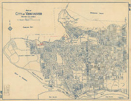
Print preview Close

Showing 1440 results

Archival description
City of Vancouver Archives technical and cartographic drawing collection With digital objects
Print preview View:

Map of City of Vancouver, British Columbia [index map]

Item is an index map of Vancouver showing the boundaries of the sectional maps in this file. Map includes streets, roads and railways; blocks, lots and legal descriptions; First Nations reserves, golf courses, cemeteries, parks and businesses along the Burrard Inlet waterfront.

Vancouver (B.C.). Office of the City Engineer

Map of Fraser Valley

Part consists of a map showing major roadways in the Lower Mainland and the Fraser Valley from Vancouver to Chilliwack, and lists of Vancouver businesses, schools, public buildings, hospitals, bathing beaches, fire halls, and golf and country clubs. Part includes text advertising the products and services of the Dominion Map and Blueprint Company.

Map of Lulu Island and Sea Island ; Municipality of Delta ; Municipality of Surrey ; Municipality of Langley ; Map of Maillardville

Part contains street maps of Lulu Island and Sea Island, Delta, Surrey, Langley, and Maillardville, tourist information about Vancouver, and text advertising the products and services of the Dominion Map and Blueprint Company.

Map of Manitoba, Kewaydin, British Columbia and North West Territory shewing the country traversed by the Canadian Pacific Railway

Item is a map showing the extent of the Canadian Pacific Railway Company (C.P.R.) in Canada in 1883. Map shows boundaries, roads, trails, telegraph lines, towns, rivers, lakes and mountainous terrain in British Columbia, the North West Territory (Alberta, Athabasca, Saskatchewan, Assiniboia), Manitoba and Kewaydin, as well as some of Ontario and Western Quebec. Map is folded inside a book titled "North West Territory, Canada."

Map of New Westminster District

Item is a commercially printed map depicting the New Westminster Land District, bounded by the Gulf of Georgia in the west, the international border in the south, range 26 of townships 1 to 4 of the Yale District in the east, and the southern half of township 6 in the north.

The map depicts townships and ranges, and district lots in incorporated areas. The map also depict Dominion Timber Berths and various types of land reserves.

Map of New Westminster District, B.C

Item is a map showing District Lots in Vancouver, and township/range designations in other areas. The map also shows False Creek Trail, North Arm Road, False Creek Road, Granville Road from Granville to Hastings, New Westminster and Burrard Inlet Road, North Road, Semiahmoo Road, New Westminster and Yale Wagon Road, and others. Annotated by W. E. Graveley, 1885, to show additional features including Kingsway, Haney, Albion Camp, etc.

Map of North America

Item is a map showing "Mr. Stuart's route through the United States, and Canada in 1828, 29 & 30" and "the boundary of the United States, both on the side of the British Possessions, & those in Mexico." The northern border of United States territory west of the Rocky Mountains is incorrectly noted at 54/40, to reflect American claims of the time.

Map of part of the New Westminster District shewing the proposed new municipality of Burnaby

Item is a map showing boundaries of a proposed new municipality of Burnaby, which would include all land outside the "old" City of Vancouver between Burrard Inlet and the Fraser River and west of North Road. The map also shows the boundaries of District Lots in this area.

Garden, Hermon and Burwell, Provincial Land Surveyors

[Map of Pioneer Place showing the area deeded to the City of Vancouver by the C.P.R.]

Item is a hand drawn map of Pioneer Place (also known as Pigeon Park), on the corner of Hastings and Carrall Streets. Map is colour coded to indicate the portion deeded to the City by the C.P.R., the portion being asked from the C.P.R. for street purposes, and the portion leased by the C.P.R. to Mr. Horne. Included on the map are Horne Block, Garden Block, a sidewalk, lanes, and a fountain. An engineer's estimates of improvements are noted on the right side of the map. Notes at the top of the map by J.S. Matthews, City Archivist read "Presented in 1934 by Ex-Alderman W.H. Gallagher. The date is about 1895."

Map of portion New Westminster District

Item is a heavily-amended copy of a map illustrating intended land settlement and subdivision in 1877 in the future sites of Vancouver, Burnaby and the North Shore, from an area bordering on English Bay to an area bordering on North Arm. Also shown are bodies of water, Hastings & Granville Road, and the settlements of Hastings and Granville. Annotations by J.S. Matthews in 1954 made on the copy are tracings in white pen and darkening the background to improve the copy.

Map of Stanley Park [site plan]

Item is a copy of a published map of Stanley Park which has been annotated to show proposed redevelopment plan for the western portion of Coal Harbour (currently Lost Lagoon) and surrounding area. It is believed that this is one of the sheets referred to by Thomas Mawson in his report to the Board of Parks Commissioners regarding various proposed development schemes for the entrance to Stanley Park and the Coal Harbour area.

Map of the municipalities of New Westminster City and District, British Columbia

Part contains a map of the Lower Mainland and Fraser Valley from the Gulf of Georgia in the west to Harrison Lake in the east. Map shows locations of churches, schools, canneries, sawmills, brickyards, tanneries, woolen mills and hatcheries; existing and proposed railways; and roadways.

Results 301 to 350 of 1440