
Fraser River - Sand heads sheet
- AM1594-MAP 1157-: LEG1153.042
- Item
- 1921
Part of City of Vancouver Archives technical and cartographic drawing collection
1440 results with digital objects Show results with digital objects
Fraser River - Sand heads sheet
Part of City of Vancouver Archives technical and cartographic drawing collection

Fraser River - Steveston sheet
Part of City of Vancouver Archives technical and cartographic drawing collection

Fraser River - Tilbury Island sheet
Part of City of Vancouver Archives technical and cartographic drawing collection

Fraser River - triangulation control
Part of City of Vancouver Archives technical and cartographic drawing collection
Fraser River and Burrard Inlet
Part of City of Vancouver Archives technical and cartographic drawing collection
Fraser River and Burrard Inlet
Part of City of Vancouver Archives technical and cartographic drawing collection
Item is a nautical chart which show details of the area surveyed from Pitt Lake in the north to Roberts Bank in the south and from (what is now) Harrison Hot Springs in the east to Bowen Island in the west. The chart shows soundings in Burrard Inlet, and along the Fraser River.
Fraser River Delta, British Columbia
Part of City of Vancouver Archives technical and cartographic drawing collection
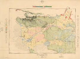
Item is a geological and topographic map covering the area of the Fraser River delta and most of the Greater Vancouver area. Map shows age and content of surface deposits; bedrock outcroppings, marshes, streams, banks and other geological features of the area; oil and gas wells and proposed drilling sites; and city streets, railways, bridges, and other built features. Includes a profile corresponding to two sections on the map: Ambleside to Vanier Park and Burrard Inlet at Burnaby Mountain to just south of the Brunette River.
Fraser River Delta, British Columbia
Part of City of Vancouver Archives technical and cartographic drawing collection
Item is a map with section showing the geology and topography of the Fraser River Delta region. The map depicts surface deposits and bedrock outcrops over different periods of time. Oil and gas well locations are also included.

Fraser River Delta, British Columbia
Part of City of Vancouver Archives technical and cartographic drawing collection
Item is a map of the Fraser River and Lower Mainland showing the following: roads, electric railways and tramways, bridges, churches, schools, post offices, cemeteries, international, municipal, township and city boundaries, wharves, lighthouses, triangulation stations and boundary monuments. Map gives topography of the land and shows water lines, tidal flats and intermittent streams.
Part of City of Vancouver Archives technical and cartographic drawing collection
File consists of 18 maps and 3 sheets of associated triangulation and other survey control data, published by the Geological Survey of Canada. The maps depict a geological survey of the banks, islands, marshes, etc. of the Fraser River, North Arm of the Fraser River and Burrard Inlet.
Fraser River to north east point of Texada Island : including Howe Sound and Jervis Inlet
Part of City of Vancouver Archives technical and cartographic drawing collection
Item is a nautical chart depicting the southern portion of the Strait of Georgia. Land shown includes (south to north): Gulf Islands, Vancouver Island to Nanoose Harbour, Vancouver area, Bowen Island, Gambier Island, Howe Sound, Seechelt Peninsula, and north to Queen's Reach. Inset map is of Tucker Bay on Lasqueti Island. The illustrations are of Georgina Point Lighthouse, Active Pass and the north shore of Gabriola Island.

Fraser Valley, Southwest B.C. & Greater Victoria
Part of City of Vancouver Archives technical and cartographic drawing collection
Part consists of road maps of the Fraser Valley and Greater Victoria, and a map of southwestern British Columbia, and a road index for the Fraser Valley map.

Fraser Valley, Surrey & Richmond
Part of City of Vancouver Archives technical and cartographic drawing collection
Part consists of the front side of a published road map. This side contains road maps of the Fraser Valley, Richmond, and Surrey, as well as street indexes.
Free map of Vancouver, New Westminster and surroundings
Part of City of Vancouver Archives technical and cartographic drawing collection
Item is a promotional brochure for the British Columbia Electric Railway Company with a map of Greater Vancouver on one side and information and advertisements on the other.

Free map of Vancouver, New Westminster and surroundings
Part of City of Vancouver Archives technical and cartographic drawing collection
Part contains information about Vancouver parks, promotional text for British Columbia Electric Railway, and advertisements for other businesses.

Part of City of Vancouver Archives technical and cartographic drawing collection
Item is a map showing railway freight lines and stops from North Vancouver in the north through northern Washington in the south, and from Chilliwack in the east to Steveston in the west.
Part of City of Vancouver Archives technical and cartographic drawing collection
Part is the front of the cover for the brochure, which includes a photograph of the Banff Springs Hotel.
Part of City of Vancouver Archives technical and cartographic drawing collection
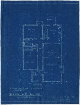
Item is an elevation drawing. The drawing has the following attestation: G.L. Warner Ltd., 1410 Royal Bank Building, Vancouver, B.C., but as this company was an insurance broker and real estate agents, it is unlikely they were responsible for creating the drawing.
It it most likely that the house was never built, as tax records show no improvements to the property until after Mrs. Oram sold it in 1936.
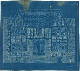
Front elevation : Leyland Apartments 916 West Broadway
Part of City of Vancouver Archives technical and cartographic drawing collection

Part of City of Vancouver Archives technical and cartographic drawing collection
S.W. Hopper Ltd.

Part of City of Vancouver Archives technical and cartographic drawing collection
Part is the cover and back page of a pamphlet. The back page is an index map of the province, showing the area covered by the main map on the interior (verso) sheet of the pamphlet.

General development plan, Exhibition Park, Vancouver, B.C.
Part of City of Vancouver Archives technical and cartographic drawing collection
Item is a map showing the Exhibition Park site, with existing buildings, proposed buildings (immediate program), proposed buildings (future program), building names and parking lot capacities.
Harland Bartholomew and Associates

General Key of Atlas/Title Page
Part of City of Vancouver Archives technical and cartographic drawing collection
Item is a map which acts as a key to the volumes of the Atlas, depicting which areas are included in which volume. The map is incorporated in the title page of the volume.
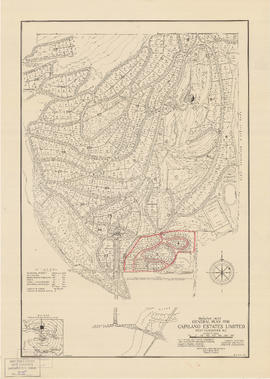
General plan for Capilano Estates Limited
Part of City of Vancouver Archives technical and cartographic drawing collection
Item is a map showing the layout of the proposed Capilano Estates development, including a golf course, a polo field, riding stables, housing lots, and park land. Annotations are pencil outlines of blocks in the southern end of the development.
Generalized land use : Greater Vancouver Regional District
Part of City of Vancouver Archives technical and cartographic drawing collection
Item is a map showing the general patterns of development in the member municipalities and electoral areas of the Greater Vancouver Regional District as of June 1979. Land use has been categorized according to the following categories : rural residential; single family residential; medium density residential; high density residential; commercial; industrial; extractive; transportation, communications and utilities; institutional; recreational areas and parks; farm; and open and undeveloped areas.
Geography, economy and tourism in south-western British Columbia
Part of City of Vancouver Archives technical and cartographic drawing collection
Part is a page containing information on population, finance, agriculture and livestock, industry, railways, labour, climate and education in British Columbia. The page includes suggested tourism itineraries for various districts within the south west reg

Geological map of parts of Nanaimo and New Westminster mining divisions
Part of City of Vancouver Archives technical and cartographic drawing collection
Item is a map showing Tertiary, Mesozoic, and Paleozoic areas and includes descriptive notes. Map drawn "To illustrate report by O. E. Leroy, M. Sc., 1906."
Goad's Atlas of the City of New Westminster, B.C.
Part of City of Vancouver Archives technical and cartographic drawing collection
File consists of the third volume of Goad's Atlas of Vancouver, and is comprised of fire insurance maps covering the City of New Westminster.
Part of City of Vancouver Archives technical and cartographic drawing collection
File consists of the first volume of Goad's Atlas of Vancouver, a series of fire insurance maps and associated information.
Part of City of Vancouver Archives technical and cartographic drawing collection
File consists of the second volume of Goad's Atlas of Vancouver, a series of fire insurance maps.
Goad's Atlas of Vancouver Vol. 1
Part of City of Vancouver Archives technical and cartographic drawing collection
Map is a fire insurance plan of the waterfront, downtown and West End portions of the City of Vancouver.
![Granville [fire insurance plan]](/uploads/r/null/f/3/1/f31b2fc3e34f1b2e375aa4d1c6089d069e20e5c43e88dd4a753a0ed961acd9c9/e011f916-304f-4655-9c90-c93af236fcbb-MAP334_142.jpg)
Granville [fire insurance plan]
Part of City of Vancouver Archives technical and cartographic drawing collection
Item is a photostat copy of a fire insurance plan of the village of Granville (the Old Granville Township part of Vancouver).
Part of City of Vancouver Archives technical and cartographic drawing collection
Map is a fire insurance map showing the buildings and structures of Granville Street (and parts of Howe Street and Seymour Street) from Beach Avenue to West Cordova Street.
![Granville [Townsite], B.C. Aug., 1885](/uploads/r/null/1/a/4/1a45ddd637fe3f3726748d5096017a8461446b9a013c408ed2b1666c8433e1f9/405fdc0d-6d88-41b7-937f-36cc7f51518a-MAP553_142.jpg)
Granville [Townsite], B.C. Aug., 1885
Part of City of Vancouver Archives technical and cartographic drawing collection
Item is a fire insurance map of the "Coal Harbour" [south shore of Burrard Inlet] area. The Hastings Saw Mill Company and Coal Harbour Fishery are shown in detail. Other businesses along Front Street are identified including hotels and stores.

Great Northern Railway. Map of the United States
Part of City of Vancouver Archives technical and cartographic drawing collection
Item is a map sheet showing the United States. The main map shows the route of the Great Northern Railway, Burlington Lines, Main Connection, other railroads, and steamship lines into US ports. The two inset maps show Great Northern Railway and steamship ines to Asia, and steamship line connections to Alaska.

Part of City of Vancouver Archives technical and cartographic drawing collection
Item is a map of Greater Vancouver annotated to show ward boundaries. Base map shows streets, some district lot numbers, and distances from City Hall. A smaller detail map shows Granville Island.
Greater Vancouver and Fraser Valley
Part of City of Vancouver Archives technical and cartographic drawing collection
Item is a pamphlet containing a map of Greater Vancouver and the Fraser Valley on one side and text promoting British Columbia and the services of Western Development and Power Limited on the other. Map shows the B.C. Electric railway line within the Greater Vancouver and Fraser Valley area, other railway lines, main roads, municipal boundaries, industrial sites, airports and ports. An inset map shows the total area served by B.C. Electric within British Columbia and the location of Greater Vancouver and the Fraser Valley within that area.

Greater Vancouver and Fraser Valley
Part of City of Vancouver Archives technical and cartographic drawing collection
Part contains a map showing the B.C. Electric railway line within the Greater Vancouver and Fraser Valley area, other railway lines, main roads, municipal boundaries, industrial sites, airports and ports. An inset map shows the total area served by B.C. Electric within British Columbia and the location of Greater Vancouver and the Fraser Valley within that area.
Greater Vancouver and New Westminster : Wrigley's official arrow city map
Part of City of Vancouver Archives technical and cartographic drawing collection
Item is a street map of Vancouver, West Vancouver, North Vancouver, Burnaby, New Westminster and the northern part of Richmond, with street index and advertisements on verso and an attached cover.
Greater Vancouver Industrial Map
Part of City of Vancouver Archives technical and cartographic drawing collection
Greater Vancouver land resource
Part of City of Vancouver Archives technical and cartographic drawing collection
Item is a pamphlet on land use in Greater Vancouver with a map and statistics on various kinds of land use.
Greater Vancouver recreation sites and parks
Part of City of Vancouver Archives technical and cartographic drawing collection
Part is the inner side of the cover in which the attached map was folded. The page includes lists of various types of recreational sites and parks in Vancouver, Burnaby, New Westminster, North Vancouver and West Vancouver.
Part of City of Vancouver Archives technical and cartographic drawing collection
Item is a road map showing Greater Vancouver on one side and downtown Vancouver and New Westminster on the other. Item also includes textual information for tourists and motorists.

Greater Vancouver road map : map cover
Part of City of Vancouver Archives technical and cartographic drawing collection
Greater Vancouver sewerage and drainage district
Part of City of Vancouver Archives technical and cartographic drawing collection
Item is a pamphlet with a map of the Greater Vancouver sewerage and drainage district on one side, and general and statistical information about the district on the other.

Greater Vancouver sewerage and drainage district : general and statistical information
Part of City of Vancouver Archives technical and cartographic drawing collection
Greater Vancouver target area. Civil defence survival instructions
Part of City of Vancouver Archives technical and cartographic drawing collection
Item is a pamphlet with instructions for evacuation of the city in case of nuclear attack. The text explains the effects a 5 megaton nuclear bomb explosion would have on the city and population. Instructions are given both for people who choose to stay in the Vancouver area and for people who choose to evacuate if a nuclear attack is anticipated. The verso of the pamphlet contains text and a map titled "Dispersal Routes for the Vancouver Zone".

Greater Vancouver votes October 17th : know your ward - know your poll
Part of City of Vancouver Archives technical and cartographic drawing collection
Part contains a map showing ward and poll numbers and locations in the City of Vancouver from Burrard Inlet in the north to the Fraser River in the south and from Boundary Road in the east to Blanca in the west.
Greater Vancouver votes October 17th : know your ward - know your poll
Part of City of Vancouver Archives technical and cartographic drawing collection
Item is a leaflet containing a map showing ward and poll numbers and locations in the City of Vancouver on one side and text advertising The Morning Star newspaper on the other.