
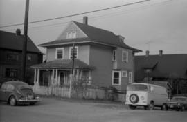
- COV-S639-1-F22-: CVA 790-0648
- Item
- [1985?]
Part of City of Vancouver fonds
1707 results with digital objects Show results with digital objects
Part of City of Vancouver fonds

Part of City of Vancouver fonds
Item is a photograph in which signs for the Aristocratic Restaurant and For Your Legs Only are visible.
Part of City of Vancouver fonds
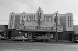
Item is a photograph of the Stanley Theatre, run by Famous Players. "Dune" in 70mm is on the marquee.

1166 West 14th Avenue (L'ecole Bilingue Elementary School)
Part of City of Vancouver fonds

1166 West 14th Avenue (L'ecole Bilingue Elementary School)
Part of City of Vancouver fonds
Part of City of Vancouver Archives technical and cartographic drawing collection
Item consists of a planning map depicting the Fairview neighbourhood.
Item is a newsletter containing a calendar of events, articles on the housing situation, information centre, and Choklit Park
Projects no. 1 and 2 maps and plans
Part of City of Vancouver fonds
File consists primarily of maps pertaining to redevelopment project 1, areas A and D, but also contains two maps from project 2. Maps include identification plans of property to be acquired; boundaries of clearance areas; general and detailed redevelopment plans; and maps showing the layout of existing and proposed utilities.

Exterior of Fairview High School of Commerce at 1540 West Broadway

Exterior of Fairview High School of Commerce at 1540 West Broadway
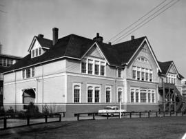
Exterior of Fairview High School of Commerce at 1540 West Broadway

Exterior of Fairview High School of Commerce at 1540 West Broadway
Exterior of Fairview High School of Commerce gymnasium

Interior of Fairview High School of Commerce, stairway and lockers

Interior of Fairview High School of Commerce, students at work in classroom

Interior of Fairview High School of Commerce, students at work on typewriters in classroom
Interior of Fairview High School of Commerce, hallway

Interior of Fairview High School of Commerce, basement

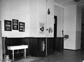
Interior of Fairview High School of Commerce, washroom

Interior of Fairview High School of Commerce, ping pong tables in basement

Interior of Fairview High School of Commerce, furnace room
![Vancouver, B.C. Plan showing location of water pipes, hydrants, etc. [Kitsilano]](/uploads/r/null/0/e/0e33cc4d2f081f551fe6919d35ea37236a6e237a2f5927834d275556995fccfc/0f6ac1ff-8457-41f3-a386-26328c66a4b0-MAP72_142.jpg)
Vancouver, B.C. Plan showing location of water pipes, hydrants, etc. [Kitsilano]
Part of City of Vancouver Archives technical and cartographic drawing collection
Item is a map showing the location of water pipes and hydrants for the area from Spruce Street to False Creek to Vine Street to Tenth Avenue (D.L. 526). Pipes and hydrants are shown in various coloured inks to indicate Installation date. Includes annotations as to whether pipes are wood or steel. Annotations have been added to a base map that is part of a larger map.
Vancouver (B.C.). Water Works Department

Part of City of Vancouver fonds
Item is a photograph showing The Grange Apartments.
![[1395 W. 14th Avenue]](/uploads/r/null/d/7/0/d70707cb9a3bdd0569a59cb0b3f4c46b6cefa5f1479312be8802c7b5675de77a/a0853d26-e6c6-431d-8fbf-a0583dabcb4b-CVA786-10_142.jpg)
Part of City of Vancouver fonds
Item is a photograph showing The Grange Apartments.
![[846 West 8th Avenue]](/uploads/r/null/f/c/c/fcc80f968016ff8e7a4369515453245b557343a1fd2e37e9c03a039d2fe88b62/b2deee4a-6173-49af-a209-ee65bf17685f-CVA1095-00041_142.jpg)
Part of City of Vancouver fonds
![[855 West 8th Avenue]](/uploads/r/null/4/0/2/402e14181ca8c9cdf4ab8569a8a10557ec2573da63bb02d671158d4b13ee8b45/981412b0-0455-448b-a22e-b0cfbbac4ee5-CVA1095-00042_142.jpg)
Part of City of Vancouver fonds
![[845 West 8th Avenue]](/uploads/r/null/e/9/8/e98b73752992e57ed957d64fe98911fa6d43b2383666082145160c0513c9dd9b/f134c750-1198-484e-abd3-6d2cf9043fea-CVA1095-00043_142.jpg)
Part of City of Vancouver fonds
![[838 West 8th Avenue]](/uploads/r/null/7/a/d/7ad1728e0f0cc9859b59de4e0e8920dc3274c5255110dbe0dc017c71fc2905f6/ed13f215-c8ec-43b4-91a4-0375e5e11953-CVA1095-00044_142.jpg)
Part of City of Vancouver fonds
Part of City of Vancouver fonds
![[717-719 West 8th Avenue]](/uploads/r/null/9/8/0/980b433b391777591d9912f88b118b848c34622a8cac9a6711aae22bd19a5ece/9fc1d7ea-66aa-4d43-8943-548b20352227-CVA1095-00048_142.jpg)
Part of City of Vancouver fonds
![[763 West 8th Avenue]](/uploads/r/null/f/9/1/f9102259127cd5571cf4e2d24e6d7ceb0cf170665fee1e9bc8ec6158f501eaed/f96de49e-dc16-4ed4-a1fa-928f2dcd0440-CVA1095-00045_142.jpg)
Part of City of Vancouver fonds
![[715 West 8th Avenue]](/uploads/r/null/3/c/f/3cf1074f76f92d3eb1d23d190e19ef85721088ac3f8fb963462e4ac1b5a278b5/f0420292-9c9f-481f-a37d-384e832f4585-CVA1095-00047_142.jpg)
Part of City of Vancouver fonds
![[745 West 8th Avenue]](/uploads/r/null/9/0/6/90685db0ef22c78d21107d53ddb293f793bfe4b986e22f6658900fe60939ff07/06e2d96d-af1e-4894-898b-1df369f5b7ed-CVA1095-00049_142.jpg)
Part of City of Vancouver fonds
![[939 West 8th Avenue]](/uploads/r/null/4/9/6/496f50815fbf45cbf3c7b59a144485b8ba5d6178f21d981938870cbde6d55ce6/7611a838-f585-440b-b989-6d49ce6c811a-CVA1095-00051_142.jpg)
Part of City of Vancouver fonds
![[933 West 8th Avenue]](/uploads/r/null/2/0/6/206240d134f71d215efa794d92241249c64fe1792c67706795706f59c3ae9a4c/04e72a86-b5b3-4ca8-a00f-426d75379607-CVA1095-00052_142.jpg)
Part of City of Vancouver fonds
![[761 West 8th Avenue]](/uploads/r/null/9/5/1/951e7e36f0f1950a80030dd7523bd82b4947f0be611a5ed4de38ed85e83c3cb5/703bdc3e-0bea-42ee-93a5-6326449766c2-CVA1095-00050_142.jpg)
Part of City of Vancouver fonds
![[944 West 8th Avenue]](/uploads/r/null/2/0/2/20295d0a91deafba5fd6f8363d9e8ad9066d66a7b816236fa4fcfbbd60f90fda/9979497e-fd4b-4188-a312-5348aa1f1e57-CVA1095-00053_142.jpg)
Part of City of Vancouver fonds
![[947 West 8th Avenue]](/uploads/r/null/b/2/0/b203f86161d910844a5a2430ac72c7c5eb37e5d72c2b18e38d74fd24800ffc11/3a5c1386-9035-41d8-9949-cde55d635915-CVA1095-00054_142.jpg)
Part of City of Vancouver fonds
![[955 West 8th Avenue]](/uploads/r/null/c/b/f/cbf7be5adde49359a55cea4c6445d885fe69a19b573202c5e45dd620c5b7cfbe/b12c5a68-7cf2-4f58-8d3b-404981165e95-CVA1095-00055_142.jpg)
Part of City of Vancouver fonds
![[926 West 8th Avenue]](/uploads/r/null/1/d/4/1d40eafb8df52c7c7d575d2b3bdac28b9779aaa9a51bbd8a717fdf30f58d904d/d802721c-4bb0-419c-bb6b-41d58682c9f6-CVA1095-00056_142.jpg)
Part of City of Vancouver fonds
![[923-927 West 8th avenue]](/uploads/r/null/0/d/7/0d77c1a14050aeffc26980291e607fd1a26442e87217cf0742c621e8596d7d57/9dee786e-a5e0-4b40-8b96-1373b72533e7-CVA1095-00057_142.jpg)
Part of City of Vancouver fonds
![[877 West 8th Avenue]](/uploads/r/null/3/c/0/3c0484469c4eeab4cef8cb86395fbf3f78208ab4f384fdb0924a9f3ef9fe6b60/8cc34431-137c-4639-a4a4-377aad809714-CVA1095-00059_142.jpg)
Part of City of Vancouver fonds
![[883 West 8th Avenue]](/uploads/r/null/c/6/f/c6f4fdefd8962e79acf0a4b38f6c0bf4e340e35a51d311db88b1c60e3d07768e/68d9b8cc-522d-47bf-9900-f28359103dc6-CVA1095-00058_142.jpg)
Part of City of Vancouver fonds
![[686 West 8th Avenue - Beaumont Block]](/uploads/r/null/3/e/d/3ed205a651c7ccd08453ddf2d421af59f470b5d2b15891c9044b4ce6b8dfbe1a/2bd29545-948e-436c-9459-979e1151711f-CVA1095-00061_142.jpg)
[686 West 8th Avenue - Beaumont Block]
Part of City of Vancouver fonds
![[686 West 8th Avenue - Beaumont Block]](/uploads/r/null/6/3/d/63dce7701db38a03d5e42b51fdf58e08eb489c2daffd27447f31b99d158972a8/6a9dc526-2e23-41aa-b3c5-df694430509f-CVA1095-00062_142.jpg)
[686 West 8th Avenue - Beaumont Block]
Part of City of Vancouver fonds
![[875 West 8th Avenue]](/uploads/r/null/9/8/a/98ad81871e48c79d89ffb1549f7dabcccf48d64e41da78a605348efddf98fa8d/f277b35f-080a-4e03-8ef3-51abdb09df35-CVA1095-00060_142.jpg)
Part of City of Vancouver fonds
![[1023 West 8th Avenue - James Evans House]](/uploads/r/null/3/8/4/38401457016efe4753b1e42260f6feec7d3d90d070f27a371b7713877a6cc821/608f6224-996e-4402-8256-12f0ae934736-CVA1095-00066_142.jpg)
[1023 West 8th Avenue - James Evans House]
Part of City of Vancouver fonds
![[977 West 8th Avenue]](/uploads/r/null/5/d/0/5d00de70596c04a34cf40b81952e4186fdc57a32590055e81a0e6f0d3c714131/9d5bdeca-c778-4ce5-b8be-b5d61d910986-CVA1095-00065_142.jpg)
Part of City of Vancouver fonds
![[975 West 8th Avenue]](/uploads/r/null/a/4/0/a407f8e0fb14f526dc536b04b3e3fdf7a650cb55979740894a4af67a00b46964/d380f59b-9324-44fd-b56f-bd1fdfbcaf7a-CVA1095-00064_142.jpg)
Part of City of Vancouver fonds
![[967 West 8th Avenue]](/uploads/r/null/0/1/8/01842933582edb38976a922373be396b368e704009768cde7154a741fd657d78/f5e6b015-df4f-424f-a661-d86b8480d581-CVA1095-00063_142.jpg)
Part of City of Vancouver fonds