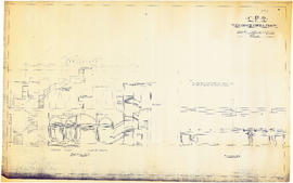
CPR Vancouver Opera House sections A-A and B-B
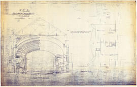
CPR Vancouver Opera House transverse section and basement plan

CPR Vancouver Opera House trusses for gallery and balcony

Plan of the City of Vancouver, British Columbia

The Municipality of South Vancouver
Plan of Point Grey municipality
Plan of Point Grey municipality
Map of South Vancouver

Map of the south-western part of British Columbia

Plan of townsite at Eburne

Vancouver and Northern Railway, 1908

Geological map of parts of Nanaimo and New Westminster mining divisions
City of Vancouver, B.C., Canada, 1908
City of Vancouver, B.C., Canada, 1908
Map and views of the terminal city, Vancouver, British Columbia, Canada
Map and views of the terminal city, Vancouver, British Columbia, Canada

Map of Grandview and east end

Warehouse and store sites : very centrally located
Revised list of remaining 50 lots in subdivision of south half of section 35, Hastings Townsite
Revised list of remaining 50 lots in subdivision of south half of section 35, Hastings Townsite

British Columbia railway belt

First Narrows. Proposed Suspension Bridge for Foot Passengers Only

Plan of subdivision of part of D.L. 526, New Westminster District, B.C., Kitsilano, City of Vancouver

First Narrows, Burrard Inlet, B.C. showing Parthia and Burnaby shoals
![Vancouver, B.C. Plan showing location of water pipes, hydrants, etc. [South Granville]](/uploads/r/null/e/a/eadb6d7351a77ac5788832abd83754cbe2966049728712aa7773bf6f2a74ff34/819e5ce5-621b-43ff-b1f5-f3bf4cac0562-MAP72_142.jpg)
Vancouver, B.C. Plan showing location of water pipes, hydrants, etc. [South Granville]
Hastings Townsite
Hastings Townsite

Coal Harbour, Vancouver, B.C.
E.J. Hill's patent boat disengaging gear
E.J. Hill's patent boat disengaging gear
Plan of Point Grey Municipality
Plan of Point Grey Municipality
D.L. 301 - Ward 8 [water pipes and hydrants]
D.L. 301 - Ward 8 [water pipes and hydrants]
![D.L. 301 - Ward 8 [location of water pipes and hydrants]](/uploads/r/null/7/b/7b8914ef9132a2e20fa03008daf1a70f3de861b767043aaf338abaeeb42423d7/ce1965c6-6a58-454c-9630-0fcba30688bf-MAP72_142.jpg)
D.L. 301 - Ward 8 [location of water pipes and hydrants]
![Vancouver, B.C. Plan showing location of water pipes, hydrants, etc. [Hastings Sunrise]](/uploads/r/null/b/c/bc8cb6a6f5ac5df0dd88a65e8a29ecceca242bde2c1b605533ad17eb835cc450/b2741291-73c5-4a98-9f41-db7fdc46fe83-MAP72_142.jpg)
Vancouver, B.C. Plan showing location of water pipes, hydrants, etc. [Hastings Sunrise]
![Vancouver, B.C. Plan showing location of water pipes, hydrants, etc. [Grandview]](/uploads/r/null/8/8/88632d271347b57b818fde723ce9ea599c725a5190b4fb2bbb11e5f98e3809ae/3657fbb2-2cf9-4d03-b885-3836ab221252-MAP72_142.jpg)
Vancouver, B.C. Plan showing location of water pipes, hydrants, etc. [Grandview]

Map and guide of Greater Vancouver
B.C. Electric Railway lines completed and under construction
B.C. Electric Railway lines completed and under construction
Southeast Hastings Townsite [water pipes and hydrants]
Southeast Hastings Townsite [water pipes and hydrants]
![Plan shewing [showing] division of property belonging to Major C.W. Hill](/uploads/r/null/0/f/0f72067c788c91a520f5055e8b1241e0ee99f2c20c434b03eca0174baea425dc/d22e8a25-814f-4266-99a4-24c639764600-MAP787_142.jpg)
Plan shewing [showing] division of property belonging to Major C.W. Hill

Plan of the municipality of South Vancouver
![Plate 46 [Thurlow Street to Canadian Pacific right-of-way to Bute Street to Georgia Street]](/uploads/r/null/5/9/f/59fddbd648aac61a1c6c56b0121fac2a9f07bd91756ebdf08cd47779553b2c7d/c80bf37d-14f8-4766-8e8c-2542a5ce2b71-1972-582_142.jpg)
Plate 46 [Thurlow Street to Canadian Pacific right-of-way to Bute Street to Georgia Street]

Plan of proposed dam, locks and wharves. Second Narrows, Burrard Inlet
![Plan of re-subdivision of lots 3 to 14, subn [subdivision] 2 of bk [block] 3. D.L. 391 & 392](/uploads/r/null/4/a/4a0ea6aa076433c7bcad0c847f7acb3bb1046f7abf2801c48b97d9ca58f49a73/9bd508e4-c85e-4090-b266-27571c5d4dbc-MAP754_142.jpg)
Plan of re-subdivision of lots 3 to 14, subn [subdivision] 2 of bk [block] 3. D.L. 391 & 392
Kitsilano and the Municipality of Point Grey
Kitsilano and the Municipality of Point Grey

Map of the Lower Mainland showing municipal boundaries and lot numbers

Sketch of proposed interurban canal and harbour development for Greater Vancouver, B.C.

Plan of the City of Vancouver, British Columbia
Guide map of the City of Vancouver and suburbs
Guide map of the City of Vancouver and suburbs
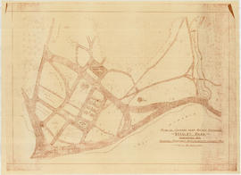
Plan of grounds near bridge entrance, Stanley Park, Vancouver, B.C. : showing proposed improvements coloured red

Lot numbers, boundaries, railway lines and street names in the municipality of Point Grey
![Map of Stanley Park [site plan]](/uploads/r/null/1/c/1c9f6dc06e0884db9e77fbf60ada5f034a83d9de980993fddeb5e2475c9e2b97/52d1c868-f7bb-48bd-a2e8-0fa3444cfeec-MAP62_142.jpg)
Map of Stanley Park [site plan]
Map of Vancouver, B.C. including Hastings Townsite and D.L. 301
Map of Vancouver, B.C. including Hastings Townsite and D.L. 301
Map of the Fraser Valley showing railway lines and district lots
Map of the Fraser Valley showing railway lines and district lots

Plan of Greater Vancouver, British Columbia

Map of the city of Vancouver, British Columbia
Map of Greater Vancouver
Map of Greater Vancouver