
Sheet 3 : Slocan Street to Boundary Road and Seventh Avenue to Charles Street

Sheet 2 : Slocan Street to Boundary Road and Charles Street to Triumph Street

Sheet 1 : Slocan Street to Boundary Road and Triumph Street to Burrard Inlet

Plan of district lot boundaries, City of Vancouver, B.C.
![City of Vancouver, British Columbia [index map]](/uploads/r/null/d/4/d4fc7ef393680c6515927aa960de863e6fd9e846c3fac12499691549673dc4b7/eed36b0b-2e63-48f2-a7ee-02ed3de937b9-MAP682_142.jpg)
City of Vancouver, British Columbia [index map]

Chart of the n.w. coast of America and n.e. coast of Asia explored in the years 1778 and1779

British Columbia

North America - West Coast. British Columbia. Burrard Inlet
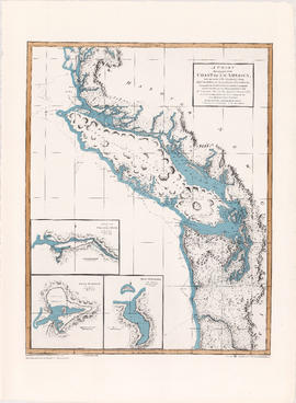
A chart shewing part of the coast of N.W. America

A chart shewing part of the coast of N.W. America
![Americae sive novi orbis, no va descriptio : [the new world, commonly called America]](/uploads/r/null/7/f/9/7f9d7722fd935fbaf645638c66c9dc9500f9c329d254d3c44493af54d80e6483/b93f8b7c-cc81-45d5-b814-14796fa7011e-MAP667_142.jpg)
Americae sive novi orbis, no va descriptio : [the new world, commonly called America]

Map of the harbour of New Westminster, British Columbia

Map showing route Vancouver to Mission

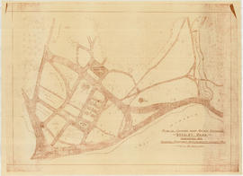
Plan showing lands occupied in Stanley Park near Brockton Point, City of Vancouver, B.C.

Lot numbers, boundaries, railway lines and street names in the municipality of Point Grey

City of Vancouver

Chinatown existing

Chinatown existing
Plan of grounds near bridge entrance, Stanley Park, Vancouver, B.C. : showing proposed improvements coloured red
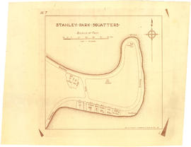
Stanley Park squatters

Plan of New Westminster City and suburban lots

Vancouver and Northern Railway, 1908
![Stanley Park [Golden Jubilee]](/uploads/r/null/2/4/24135e2d726e60ffbc74f0d81c3a53d51a38fe9ea1e86ecda92708249adac23b/1b46df5d-6871-41b2-b1dd-91a0c1d5ad02-MAP624_142.jpg)
Stanley Park [Golden Jubilee]

Sketch showing traffic plan for night functions in Stanley Park during Golden Jubilee period

Plan of the townsite of North Vancouver
![Map of Stanley Park [site plan]](/uploads/r/null/1/c/1c9f6dc06e0884db9e77fbf60ada5f034a83d9de980993fddeb5e2475c9e2b97/52d1c868-f7bb-48bd-a2e8-0fa3444cfeec-MAP62_142.jpg)
Map of Stanley Park [site plan]
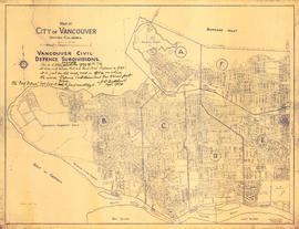
Vancouver civil defense subdivisions

Map of part of the New Westminster District shewing the proposed new municipality of Burnaby

City of New Westminster British Columbia

Vancouver, B.C. 1890 : built-on area

Plan showing lands occupied in Stanley Park near Brockton Point. City of Vancouver B.C.

Vancouver : urban growth, 1865-1970

Location of ferry pedestrian subway, Vancouver, B.C.
![Municipality of North Vancouver [Burrard Inlet]](/uploads/r/null/6/d/6d0d9a4b75b38672c56aa89a5984fe2d0e6d66be85f6f375cbe8e2fd7ac94a98/577914e1-3de2-478b-a629-5f391731387a-MAP588_142.jpg)
Municipality of North Vancouver [Burrard Inlet]

City of Vancouver
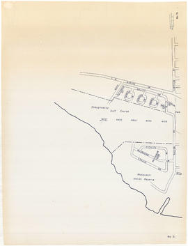
Sheet 31 : Camosun Street to Shaughnessy golf course to Fraser River to Salish Drive

Sheet 28 : Main Street to Twenty-ninth Avenue to Granville Street to Fiftieth Avenue

Sheet 26 : Highbury Street to English Bay to Tasmania Boulevard to Seventeenth Avenue

Sheet 25 : Balaclava Street to Fifteenth Avenue to Blanca Street to Thirty-fifth Avenue
Sheet 24 : Balaclava Street to English Bay to Tolmie Street to Nineteenth Avenue

Sheet 23 : Vine Street to Forty-first Avenue to Salish Drive to Fraser River
Sheet 22 : Vine Street to Thirty-first Avenue to Camosun Street to Fifty-first Avenue

Sheet 21 : Cypress Street to West Fifteenth Avenue to Highbury Street to Thirty-fifthe Avenue

Sheet 20 : Granville Street to English Bay to Trutch Street to West Sixteenth Avenue

Sheet 19 : Cambie Street to Fifty-seventh Avenue to Arbutus Street to Fraser River

Sheet 18 : Laurel Street to West Forty-ninth Avenue to Marine Crescent to Seventieth Avenue
Sheet 17 : Oak Street to Connaught Street to Elm Street to West 50th Avenue

Sheet 16 : Cambie Street to West Fifteenth Avenue to Arbutus Street to Thirty-fifth Avenue

Sheet 15 : Columbia Street to Drake Street to Cypress Street to West Eighteenth Avenue

Sheet 14 : Prince Albert Street to Forty-ninth Avenue to Laurel Street to Kent Avenue