
1957 Aerial photos of BC Sugar
- AM1592-1-S2-F10-: 2011-092.3678
- Item
- 1957
462 results with digital objects Show results with digital objects
1957 Aerial photos of BC Sugar

1957 Aerial photos of BC Sugar

1957 Aerial photos of BC Sugar

Aerial photograph of BC Sugar refinery and surrounding area
Item is a photograph showing the M.V. Phaedra at the BC Sugar dock.

Aerial photograph of BC Sugar refinery and surrounding area
Item is a photograph showing the M.V. Phaedra at the BC Sugar dock.

Aerial photograph of BC Sugar refinery and surrounding area
Item is a photograph showing the M.V. Phaedra at the BC Sugar dock.
![[View of Vancouver waterfront showing Union Dock]](/uploads/r/null/d/d/7/dd7ab36410c42b9534434120e65592352742facf102963e83e7d56a08e4dd00e/88ad4685-0b94-4bb5-801e-318dd133e0f9-CVA374-145_142.jpg)
[View of Vancouver waterfront showing Union Dock]
Oblique view showing C.P.R. Pier H, and the Evans, Coleman and Evans docks, buildings near the waterfront and the Georgia Viaduct in the background
![[View of Vancouver Waterfront showing Union Dock]](/uploads/r/null/c/e/e/cee95cbf9aaa5e1575599f13a63661f6af1be660e92b8121f91e9cf4da242d14/bfb01bf2-4ce4-4ce5-a8d2-6b7244d5e1df-CVA374-146_142.jpg)
[View of Vancouver Waterfront showing Union Dock]
Oblique view showing C.P.R. Pier H, and the Evans, Coleman and Evans docks
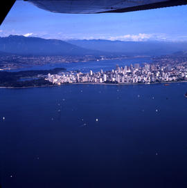
![[Aerial view of West End and Stanley Park]](/uploads/r/null/4/d/4/4d4e724e2a486490856fe60b67dfeee43429a3860f0dd9901058a9e86f640a07/120e79a6-7374-40bd-b57b-8eaac78f191c-CVA374-180_142.jpg)
[Aerial view of West End and Stanley Park]
Oblique view showing English Bay and North Vancouver in the background
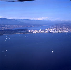
![[Aerial view looking northwest of the West End and Stanley Park]](/uploads/r/null/8/8/7/887dd5ff7e349fb28124477bf87837887e09eb02be29444c2ab484fb9068ab51/a90b562e-ef47-480e-b13c-5cb26250e139-CVA374-181_142.jpg)
[Aerial view looking northwest of the West End and Stanley Park]
Oblique view showing English Bay, Lost Lagoon, Coal harbour and West Vancouver in the background

Aerial view of three bridges at Second Narrows
Part of Vancouver Express fonds
Item is a photograph showing an aerial view of three bridges at Second Narrows. Caption from Vancouver Express: "Three bridges at Second Narrows will soon be down to two as old structure (centre) is slated for demolition. Rail traffic which once used old bridge now travels over CN rail bridge which was completed last year. Aerial photo was taken from Harrison Airways Cessna 172, piloted by Hugh Fraser."

Aerial view of Vancouver city centre looking east
Part of Vancouver Express fonds

Aerial view of Vancouver city centre showing waterfront to the east
Part of Vancouver Express fonds
Item is a photograph showing an aerial view of Vancouver city centre with waterfront to the east. Photo was taken from Harrison Airways Cessna I72 piloted by Hugh Fraser.

Aerial view of Vancouver harbour towards Second Narrows
Part of Vancouver Express fonds

Aerial view of eastern portion of Vancouver Harbour showing Vancouver Terminal
![[Aerial view from helicopter] - Head of False Creek](/uploads/r/null/a/5/2/a527adaeb4fda0fe18bd9816926d856bf2d41648b53e58a89995a6c4f2448968/87326953-3b12-49d7-a9c8-49fe5592f57d-CVA160-13_142.jpg)
[Aerial view from helicopter] - Head of False Creek
Part of William Orson Banfield fonds
![[Aerial view from helicopter ] - West End and Apartment Houses](/uploads/r/null/d/a/6/da60d9abc1bd91d0ea3101fcb41b2966ca04034f3a70be4c92d74fdf45003723/7c1ab258-67bf-4f12-a5d8-14bf9ce46fed-CVA160-14_142.jpg)
[Aerial view from helicopter ] - West End and Apartment Houses
Part of William Orson Banfield fonds
![[Aerial view from helicopter] - West Point Grey](/uploads/r/null/a/d/2/ad2d7a1729e13d635ae471fddd372c80d39e4234716f35b4990f68e863b2f236/3785ce48-0e53-4fa7-be64-30e658feab6f-CVA160-15_142.jpg)
[Aerial view from helicopter] - West Point Grey
Part of William Orson Banfield fonds
![[Aerial view from helicopter] - Log booms in Pt. Grey](/uploads/r/null/a/2/b/a2b1142e0ddac9825111a245c8947b8a84fe967ce6e25381974cbfcd433dc223/40e3b896-533e-438b-abd3-c08f264647dc-CVA160-16_142.jpg)
[Aerial view from helicopter] - Log booms in Pt. Grey
Part of William Orson Banfield fonds
![[Aerial view from helicopter] - Hastings Park](/uploads/r/null/6/1/3/61318c3fe113076751adabc84437f0ed0f1092cc4ad36eeaee54e3cfe748f333/299d30c4-6869-45a6-889a-207f041887b9-CVA160-17_142.jpg)
[Aerial view from helicopter] - Hastings Park
Part of William Orson Banfield fonds
![[Aerial view from helicopter] - Loading Dock, North Shore](/uploads/r/null/5/5/8/55817de9fa2c5c9e526598de5ea55ab054f16539b0a7f2af80ff63048cae0227/280d64d2-95c9-4255-8e24-bfb316b7b961-CVA160-18_142.jpg)
[Aerial view from helicopter] - Loading Dock, North Shore
Part of William Orson Banfield fonds
![[Aerial view from helicopter] - Hastings Park](/uploads/r/null/a/2/d/a2d3c20cdf614680a99347e453f27e1896ef0cce91ef8ca7ec0d75c600afb9cc/d34dbb2f-06a8-4130-8980-25bb05349193-CVA160-19_142.jpg)
[Aerial view from helicopter] - Hastings Park
Part of William Orson Banfield fonds
![[Aerial view from helicopter] - Granville Bridge looking south](/uploads/r/null/0/5/f/05fd49f91cfc41f1fdb5dffdeb8a96e1ec60275e5f157a6ccf918d4604232bff/2e2746d5-5ab9-4e02-8124-07b32e01153d-CVA160-20_142.jpg)
[Aerial view from helicopter] - Granville Bridge looking south
Part of William Orson Banfield fonds
![[Aerial view from helicopter] - Trans Canada Highway](/uploads/r/null/1/0/e/10eef24038760063ce10fb3c6ba332e347f7b483f567bc9c2ceac3b840575f22/e9e59724-c506-4e86-a00a-d9720b792c65-CVA160-21_142.jpg)
[Aerial view from helicopter] - Trans Canada Highway
Part of William Orson Banfield fonds
![[Aerial view from helicopter] - Shaughnessy and Quilchena](/uploads/r/null/f/f/0/ff08aaeeaea21ae38140e18966d54e6d4a93b1988c3516e585585ee218a6a227/a865e632-a40a-42f1-a10d-7c9f5a6c7cba-CVA160-22_142.jpg)
[Aerial view from helicopter] - Shaughnessy and Quilchena
Part of William Orson Banfield fonds
![[Aerial view from helicopter] - Shaughnessy Golf Club House](/uploads/r/null/5/d/5/5d5d8792969484ccece23357dbd8823275df30c087900509f9ad9548c867dd0d/09e33ad9-ff16-4e4b-9552-5a181fd0d2dc-CVA160-23_142.jpg)
[Aerial view from helicopter] - Shaughnessy Golf Club House
Part of William Orson Banfield fonds


Aerial view of the Convent of the Sacred Heart
Item is a photograph showing an aerial view of Sacred Heart Convent, looking north, bounded by Dunbar Street and U.B.C. Endowment Lands.

Part of Frank Appelbe fonds

Part of Frank Appelbe fonds

Part of Frank Appelbe fonds

Part of Frank Appelbe fonds

Part of Frank Appelbe fonds

Part of Frank Appelbe fonds

Part of Frank Appelbe fonds
Part of Frank Appelbe fonds

Part of Frank Appelbe fonds

Part of Frank Appelbe fonds

Part of Frank Appelbe fonds

Part of Frank Appelbe fonds

Part of Frank Appelbe fonds

Part of Frank Appelbe fonds

Part of Frank Appelbe fonds

Part of Frank Appelbe fonds

Part of Frank Appelbe fonds
Part of Frank Appelbe fonds

Part of Frank Appelbe fonds

Part of Frank Appelbe fonds

Part of Frank Appelbe fonds

Part of Frank Appelbe fonds