
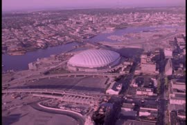
Vancouver from top of old Hotel Vancouver
- AM1545-S3-: CVA 586-4397
- Item
- June 20, 1946
Photograph shows a view looking north showing Pier B-C, the Main Post Office, the Royal Bank Building and ferries
462 results with digital objects Show results with digital objects
Vancouver from top of old Hotel Vancouver
Photograph shows a view looking north showing Pier B-C, the Main Post Office, the Royal Bank Building and ferries

Vancouver from top of old Hotel Vancouver
Photograph shows a view looking northeast

View shows Lions Gate Bridge and Stanley Park.
![[View of Victoria Harbour an] Parliament Buildings](/uploads/r/null/9/2/92c1339ecc880e2165a05beaee358355b4c5da0b6c0f0d6742919864aa275115/1498ef9f-3d2b-4af3-b61e-dfaa48987973-A07157_142.jpg)
[View of Victoria Harbour an] Parliament Buildings


Lipsett boats - "Harris No.3", "Hollyburn"
![Fishing boats at Prince Rupert [docks]](/uploads/r/null/5/7/57cad72795de5981d5a1b74a4b6e885953b245c18485282f0028b8559053341c/2d2e9b4d-9594-40be-8441-6632a03ff306-A07220_142.jpg)
Fishing boats at Prince Rupert [docks]
Thor and Mikof boats indentified in photograph.
![[View of] Ocean Falls [harbour and buildings]](/uploads/r/null/3/3/33daeb90796231f592329cba7a2cbd32a2d2e5ec9d397a7151a925a416d514b8/860dc270-0c78-4f59-9c8e-a01712ccce45-A07221_142.jpg)
[View of] Ocean Falls [harbour and buildings]
![[View of] Ocean Falls [from harbour]](/uploads/r/null/a/c/ac01a62213024629cc4ad1b26c89a5bc072b7b6495192754174509e3aa713da0/d414e587-97bb-4d8e-99e2-b8f5ef2471f8-A07225_142.jpg)
[View of] Ocean Falls [from harbour]

![[Views of boats in] Deep Cove [harbour]](/uploads/r/null/b/9/b9f273fdf8c32c5165d86836e5ca1d3f2c41548f1aec61f7261df0be041d12a8/6a46c1b6-9ded-4685-a959-ced739e246f2-A03405_142.jpg)
[Views of boats in] Deep Cove [harbour]
![[View of] Deep Cove](/uploads/r/null/1/a/1a18c33f69dd89ad4f2e79c0137c837c16e817069547777a7c1f9daf2542a46f/4fe48ffe-0985-498a-acd7-92c6d74245b0-A03406_142.jpg)

Part of Yaletown Productions Inc. fonds
Item is a tourist promotional video for travelling in Alaska. Features shots showing off the Alaskan landscape, following a train of tourists on their route to Northern Alaska. Includes footage of dogsledding and snowmobiling. Video has a predominantly country music soundtrack. Dubbed in Japanese with Japanese title screens and Japanese credits.
NHK [Nippon Hoso Kyokai; official English name: Japan Broadcasting Corporation]

Provincial Reports - "That's The BC Spirit"
Part of Yaletown Productions Inc. fonds
Item is a sponsored production produced by Yaletown Productions Inc. Item consists of ten, two minute, "Province Reports," with Fred Latrimouille, produced by Yaletown Productions for the government of British Columbia's "B.C. Enterprise" program. In the order that they appear on the tape they are:
-Province Report 2 "People Place/Jobs" (Oct. 5, 1982)
-Province Report 7 "Burden /Restraint" (Oct. 5, 1982)
-Province Report 9 "Teamwork/Employment Initiatives" with Grace McCarthy, Minister of Human Resources (Oct. 5, 1982)
-Province Report 10 "Getting around/Transportation" (Oct. 5, 1982)
-Province Report 11 "Future jobs/Education" (Oct. 5, 1982)| Province Report 1 "Mega projects/Jobs" (Sept. 20, 1982)
-Province Report 3 "Coalscene/Resource Mgmnt [management]" (Sept. 20, 1982)
-Province Report 4 "Transportation/Ports" (Sept. 20, 1982)
-Province Report 6 "Work share/Jobs" (Sept. 20, 1982)
-Province Report 8 "Foundations/Economic strategy" (Sept. 20, 1982)
Recording includes interview clips with various provincial politicians including Stephen Rogers, William Vander Zalm, James Hewitt, Don Phillips, Grace McCarthy and others.
Allscreen - Vancouver - reel #4
Part of Yaletown Productions Inc. fonds
Film consists of raw footage of scenes of Vancouver used in the video postcard "Vancouver - The World in a City." Film features aerial views of: B.C. Place Stadium, the City of Vancouver from Stanley Park, Coal Harbour, the seawall, Stanley Park, the downtown area, the B.C. Ferries-run seabus, the Vancouver Trade and Convention Centre still under construction, the Expo Centre (now the Telus World of Science) under construction, as well as views of the development of the Expo site, the Fraser river, log booms on the Fraser river, the Airport, the University of British Columbia campus, and the Lions Gate bridge. Silent film.
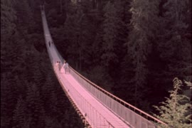
Allscreen - Vancouver - reel #5
Part of Yaletown Productions Inc. fonds
Film consists of raw footage of Vancouver that was used in video post card "Vancouver - The World in a City." Footage includes scenes of the Lynn Valley suspension bridge, the Grouse Mountain 'Skyride' (gondola), views from Grouse Mountain of the Lower Mainland, the Expo 86 site under construction, B.C. Place Stadium, the Expo Centre (now the Telus World of Science) under construction, and people walking in downtown Vancouver, City Hall, Simon Fraser University campus in Burnaby B.C., and the University of British Columbia campus, Silent film.

Part of Yaletown Productions Inc. fonds
Film consists of raw footage used in video post card "Vancouver - The World in a City." Footage features scenes of the Vancouver Trade and Convention Centre, Coal Harbour, airplanes featuring the Expo 86 logo on the tail end, a few panning shots and some wide shots from the south side of False Creek of the entire Expo 86 grounds partially constructed and the partially completed Cambie Street bridge. Silent film.
![BC [British Columbia] postcard - The Rockies to the Pacific](/uploads/r/null/1/2/1226936/e2a6b4cf-7e7e-48c3-8e3b-6a150d917129-MI-342_142.jpg)
BC [British Columbia] postcard - The Rockies to the Pacific
Part of Yaletown Productions Inc. fonds
Film is a promotional video for the province of British Columbia. Focusing on different sections of the province in turn the video highlights the features and tourist attractions of each. According to the donor this is most likely the original of the final production with sound and image. Director Mike [Michael] Collier; cinematography Norm Keziere, Dave Geddes, Bob Asgeirsson, Bill Rounds, Tommy Tompkins, and John Anderson; editor Rober Brandreth-Gibbs; research Sharon McGowan; narration script Don White and Sharon McGowan, narrator Art Hives; video services Post Haste Video; film lab Alpha Cine Services; sound mix Pinewood Studios; special thanks to Tourism British Columbia. Produced by Yaletown Productions. b&w 00:10:57-00:11:04 and 00:18:47-00:19:22.
![BC [British Columbia] postcard - The Rockies to the Pacific [Japanese version]](/uploads/r/null/1/2/1226943/1fe338ae-0558-47de-bc78-ac3a556700b9-MI-343_142.jpg)
BC [British Columbia] postcard - The Rockies to the Pacific [Japanese version]
Part of Yaletown Productions Inc. fonds
Film is a promotional video for the province of British Columbia this version has Japanese narration. Focusing on different sections of the province in turn the video highlights the features and tourist attractions of each. According to the donor this is most likely the original of the final production with sound and image. Director Mike [Michael] Collier; cinematography Norm Keziere, Dave Geddes, Bob Asgeirsson, Bill Rounds, Tommy Tompkins, and John Anderson; editor Rober Brandreth-Gibbs; research Sharon McGowan; narration script Don White and Sharon McGowan, narrator Art Hives; video services Post Haste Video; film lab Alpha Cine Services; sound mix Pinewood Studios; special thanks to Tourism British Columbia. Produced by Yaletown Productions. Ends with an advertisement for 'Canada's Best Selling Video Postcard Series.' b&w 00:10:57-00:11:04 and 00:18:47-00:19:22.

Part of Yaletown Productions Inc. fonds
This item consists of raw footage featuring B.C./Expo 86 aerials; shot in 35mm and transferred to one inch tape. Original negative no longer exists and only video footage survives. Some of this material was used in Yaletown Production's video postcard series. Includes nighttime footage of downtown Vancouver.

Part of Yaletown Productions Inc. fonds
This item consists of raw footage featuring B.C./Expo 86 aerials; shot in 35mm and transferred to one inch tape. Original negative no longer exists and only video footage survives. Some of this material was used in Yaletown Production's video postcard series. There are several shots of the B.C. Pavillion, now the Telus World of Science; including nighttime shots of the B.C. Pavillion, the Expo grounds and the city. Some scenes have been sped up.

Part of Hubert William Lovell fonds
Photograph was taken in the summer.

Eagle Harbour, old logging buildings
Part of Hubert William Lovell fonds
Photograph was taken in the summer.

Part of Hubert William Lovell fonds
Photograph was taken in the summer.
![Vancouver harbour from the roof garden [of David] Spencer's [Department] Store](/uploads/r/null/d/b/db5a883c9aac8bed679b57c2205d549efa86b2a28446fb64721146f1befa6a70/d5e169c6-2878-4aa0-ae91-fea056b71eac-CVA258-8_142.jpg)
Vancouver harbour from the roof garden [of David] Spencer's [Department] Store
Part of Hubert William Lovell fonds
Pier D, Empress of Russia, Deadman's Island and Brockton Point are visible in the distance. Photograph was taken in the summer.

The rum-runner 'Trucilla' enters Vancouver Harbour

Princess Elaine enters Vancouver Harbour on maiden voyage to join the C.P.R. Princess fleet

'Greenhill Park' ship explosion in Vancouver Harbour

Granville, B.C. 1885 - C.P.R. plan


![Harbour panorama [with] war canoe](/uploads/r/null/1/3/5/13571c1c3dc1e530a1e923e7264be75706d8af95af9a588dcf00ff1206d334c5/cd1f3b56-7afa-4c5c-ac2a-92ed07ed331a-2011-010_142.jpg)
Harbour panorama [with] war canoe
Harbour during the Blushes Beautiful Ski to Sea Relay Race
![[South side of Coal Harbour at low tide with four-man scull]](/uploads/r/null/5/d/5d701a946729d7f820e43fd05966163d0f63a80eebee16e404fb12ca24cb73f7/1d70962a-414f-40fe-8b16-3cfc609c2393-A20515_142.jpg)
[South side of Coal Harbour at low tide with four-man scull]
Part of James Luke Quiney fonds
![N.P.A.A.O. [North Pacific Association of Amateur Oarsmen. Four-man sculls at] Esquimalt](/uploads/r/null/3/9/9/39987f37873391a1c3f2c8d1a3117b3b780fd35f99916cea9c357f5094bb1227/15ea02ff-5b9a-4e86-9d07-ac6d7e360763-CVA7-317_142.jpg)
N.P.A.A.O. [North Pacific Association of Amateur Oarsmen. Four-man sculls at] Esquimalt
Part of James Luke Quiney fonds
![N.P.A.A.O. [North Pacific Association of Amateur Oarsmen. One-man scull at] Esquimalt](/uploads/r/null/2/c/7/2c7a041f4573b48dfe710ad66ac640d7e95a4566083535aa2ed127c5268a1b18/931a73ba-3eb4-4564-9a85-04a72e883331-CVA7-318_142.jpg)
N.P.A.A.O. [North Pacific Association of Amateur Oarsmen. One-man scull at] Esquimalt
Part of James Luke Quiney fonds

Part of James Luke Quiney fonds

Part of City of Vancouver Archives technical and cartographic drawing collection
Item is a map showing major landmarks, railway lines, harbour lands reclaimed, proposed wharves and piers, retaining walls and dredging, and soundings in fathoms in Vancouver Harbour (Burrard Inlet) and False Creek.
Plan of False Creek, Vancouver, B.C.
Part of City of Vancouver Archives technical and cartographic drawing collection
Map shows streets, railways, land to be reclaimed, foreshore applied for, foreshore granted by order in council, proposed wharf lines, areas to be dredged and land ownership in and along False Creek. A key map in the top right-hand corner shows the location of False Creek in relation to the rest of Vancouver.

Plan of the City of Vancouver, B.C.
Part of City of Vancouver Archives technical and cartographic drawing collection
Item is a map of the old City of Vancouver south to 16th Avenue. The map depicts District Lots and blocks, railway lines, street car lines, industrial areas, parks, postal information, schools, property boundaries.
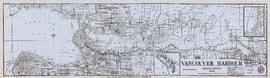
Tidal current charts : Vancouver Harbour, British Columbia
Part of City of Vancouver Archives technical and cartographic drawing collection
Item is a booklet containing twelve charts showing tidal currents in Vancouver Harbour at different points in the tidal cycle.
Vancouver, British Columbia. Souvenir from the lion gateway
Part of City of Vancouver Archives technical and cartographic drawing collection
Item is a promotional brochure for the City of Vancouver, included as a holiday supplement in the Vancouver Daily and Weekly World newspapers. The brochure was designed to be folded.
Vancouver Harbour, British Columbia, 1945
Part of City of Vancouver Archives technical and cartographic drawing collection
Item is a nautical chart showing English Bay and Burrard Inlet with soundings in feet, anchorages, locations of submarine cables, and ferry lines. Land features include city blocks and district lot numbers. Includes inset maps of the North Arm of Burrard Inlet and Vancouver Island. Note at the bottom of map states, "Not to be used for navigational purposes."
The Port of Vancouver : Canada's key city of the West
Part of City of Vancouver Archives technical and cartographic drawing collection
Item is a brochure promoting Vancouver harbour as a hub of economic activity in the city. The brochure includes illustrations of harbour activity, facts about various aspects of the operations to show the harbour's capacity and facilities.

Vancouver Harbour, British Columbia, 1932
Part of City of Vancouver Archives technical and cartographic drawing collection
Item is a nautical chart showing English Bay and Burrard Inlet with soundings in feet, anchorages, locations of submarine cables, and ferry lines. Land features include city blocks and district lot numbers. Includes inset maps of the North Arm of Burrard Inlet and Vancouver Island.
Vancouver Harbour, British Columbia, 1964
Part of City of Vancouver Archives technical and cartographic drawing collection
Item is a nautical chart showing English Bay and Burrard Inlet with soundings in feet, anchorages, locations of submarine cables, and ferry lines. Land features include city blocks and district lot numbers. Includes inset maps of the North Arm of Burrard Inlet and Vancouver Island.
Part of City of Vancouver Archives technical and cartographic drawing collection
Item is a brochure promoting tourism along the British Columbia coast using Union Steamships routes. The unfolded brochure has text and illustrations on one side and on the other text with a map showing the routes to destinations described in the brochure.

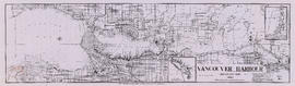
Vancouver Harbour : Sheet 1 (First Narrows to Second Narrows)
Part of City of Vancouver Archives technical and cartographic drawing collection
Item is a nautical chart of Vancouver Harbour from First Narrows in the west to Second Narrows in the east, showing soundings in fathoms, tidal information, anchorages, beacons, and waterfront businesses. Street names are shown on land areas.