
- AM1535-: CVA 99-3445
- Item
- [ca. 1924]
Part of Stuart Thomson fonds
534 results with digital objects Show results with digital objects
Part of Stuart Thomson fonds
![Hudson Bay Delivery Truck [and Driver]](/uploads/r/null/b/9/b9a769f4bcc9243ea402ecb62647df2631165db815280b0729c36d231551f082/4aea9423-f728-4b9b-9a98-a0dbfca50ee9-A16972_142.jpg)
Hudson Bay Delivery Truck [and Driver]
Part of Stuart Thomson fonds

Hudson's Bay Company Delivery Truck
Part of Stuart Thomson fonds

Hudson's Bay Company Delivery Truck
Part of Stuart Thomson fonds
![[Hudson's Bay Company trucks and employees gathered in a parking lot]](/uploads/r/null/d/e/de0b24e240715a097db3bbd34c2b6cb58ed03c37b3a79571ec4873c7300e84f0/66388b4d-993c-4164-aff7-cd430d5355a5-A12988_142.jpg)
[Hudson's Bay Company trucks and employees gathered in a parking lot]
![[Imperial Oil Ltd. Gasoline Service Station (590 Hornby Street) Auto Filler No. 4]](/uploads/r/null/6/0/602ab7b2d985c652ef011c08d188276374b7bdbf6d4b031844d45897fe050a2c/30370fb8-df60-40c2-b241-768eae6e24e8-A31904_142.jpg)
[Imperial Oil Ltd. Gasoline Service Station (590 Hornby Street) Auto Filler No. 4]
Part of Major Matthews collection
Men identified (left to right): Alfred Huggett, J.E. Hayden, unidentified man in car, Stan and Jack Duggan. Photograph also shows the B.P.O.E. Club rooms (901 Dunsmuir Street) and houses from 570 to 558 Hornby Street.

Imperial Tobacco Company "Sweet Caporal Cigarettes" truck
Part of Stuart Thomson fonds

Imperial Tobacco Company "Sweet Caporal Cigarettes" truck
Part of Stuart Thomson fonds
![[Industrial Electricians truck parked outside the W.R. Carpenter (Canada) Ltd. Warehouse]](/uploads/r/null/5/6/56af0f721a24ec41f9b25623cc3a6afdc195e193df62ca5c007a8e9920dbdcb8/38c3a633-ed8f-40c8-a273-8108896dd673-A12417_142.jpg)
[Industrial Electricians truck parked outside the W.R. Carpenter (Canada) Ltd. Warehouse]
Part of City of Vancouver fonds
Map is Plan no. 4105A Sheet 8 of 11 of the City of Vancouver, showing streets, blocks, hospitals, golf courses, First Nations reserves, parks, schools, city yards and cemetery. Map is hand coloured to show designated routes, designated areas for different sizes of commercial vehicles, the central district and areas zoned for industry. Map is labelled "1963 4105 A-8 Industrial Study 1964." Base map is amended to May 1961.
![International Harvester Co. - Mills Bros. trucks at Langley [Loading logs onto a truck]](/uploads/r/null/3/b/7/3b7e50f3dbc94ac7a62c4245eae01aa2165d36ce61e25eb5b748289b0557eaf7/9be69941-554d-4e13-ab1f-fb1f2a54fb52-CVA99-7699_142.jpg)
International Harvester Co. - Mills Bros. trucks at Langley [Loading logs onto a truck]
Part of Stuart Thomson fonds
![International Harvester Co. - Mills Bros. trucks at Langley [Loading logs onto a truck]](/uploads/r/null/2/3/9/2394093214dfddb205cbc1cd36b925907ec52b1556cebf31d4d6516eb5a1ae9a/08482bca-b3bc-4ebc-a9c1-04d2aaceb7ca-CVA99-7700_142.jpg)
International Harvester Co. - Mills Bros. trucks at Langley [Loading logs onto a truck]
Part of Stuart Thomson fonds
![International Harvester Co. - Mills Bros. trucks at Langley [Truck at logging operation]](/uploads/r/null/1/f/e/1fe94b3f8488617aa8eb2d00cdd183ba7338d53f64a8bdf49199c41e16454dab/f5066380-b999-4379-9952-629f7080c64a-CVA99-7698_142.jpg)
International Harvester Co. - Mills Bros. trucks at Langley [Truck at logging operation]
Part of Stuart Thomson fonds

International Harvester Co. B&K truck
Part of Stuart Thomson fonds
![International Harvester Co., Cross & Co., truck [in front of Moose Temple, 636 Burrard]](/uploads/r/null/1/f/1f9798213f4e5fdfa30aea1855a42b7951d95981145f4868eb322f92a4a7c1d6/ea3fe083-e2c7-4a34-89ff-e656e1253852-A01600_142.jpg)
International Harvester Co., Cross & Co., truck [in front of Moose Temple, 636 Burrard]
Part of Stuart Thomson fonds
![International Harvester Company new showroom [at 1135 Seymour Street]](/uploads/r/null/7/1/71e636e75aaf4ab9aad5946105e39fbe9a4fc780876dec8a4d03dcc2820f6977/7281a523-b571-48af-ad9a-2335da6c3ac6-A18642_142.jpg)
International Harvester Company new showroom [at 1135 Seymour Street]
Part of Stuart Thomson fonds

International Harvester Company service truck
Part of Stuart Thomson fonds
![International Harvester Company [truck being loaded onto the "Princess Louise"]](/uploads/r/null/e/4/e4db1b6627117fd9527e4fa801695ec05be5aff6d836f4c43b260c66aba29f7e/3ceac47e-d914-488e-b941-9f7aeb6f0503-A18542_142.jpg)
International Harvester Company [truck being loaded onto the "Princess Louise"]
Part of Stuart Thomson fonds
![International Motor Trucks Limited [at 1135 Seymour Street]](/uploads/r/null/d/2/d226a6de61b47aa39e8f0922bdfcadbb887515aa05ad79d6f16185f0e6f56ba1/2e2b0082-bb0e-4cd1-9853-5bb022ce634b-A17404_142.jpg)
International Motor Trucks Limited [at 1135 Seymour Street]
Part of Stuart Thomson fonds
Photograph shows a Brackman-Ker Milling Company truck

International Truck Agency - Truck
Part of Stuart Thomson fonds
Photograph shows a dump truck

International Truck Agency - Truck
Part of Stuart Thomson fonds
Photograph shows a dump truck
![Johnson [National] Storage - New Building [at 1396 Richards Street]](/uploads/r/null/1/8/18416a2a4f512f0c9ff1e5f3618f3b11577d47777bcef51feddde3458e3993c7/046d8941-0956-425e-9bcb-d644e1dc6067-A17466_142.jpg)
Johnson [National] Storage - New Building [at 1396 Richards Street]
Part of Stuart Thomson fonds
Photograph shows signs for Libby McNeill and Libby and Clare Brothers Western Limited
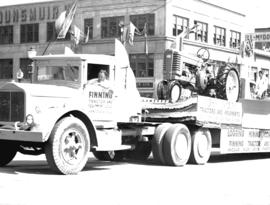
![Jubilee Parade Caterpillar Diesel Engines [distributed by Finning Tractor and Equipment Company] ...](/uploads/r/null/1/9/19f851a0c3461c27048d60bfc93c031129e018c2d4ece8729f6c5c25d56f8683/6b7f68f5-709f-486f-b09e-a1a29f9d6f6d-A15348_142.jpg)
Photograph shows an Arrow Transfer truck
Jubilee Parade "John Deere" tractor float
Photograph shows a Finning Tractor and Equipment Company truck

Jubilee Parade Lumber Carrier Service float
Photograph shows the Mackenzie, White and Dunsmuir Limited building
![Jubilee Parade [showing a view looking north on Burrard Street]](/uploads/r/null/b/4/b4e0a6fcc6e25d33d9e05465a97a96ee260c637c8152309eac9b521a2c8317e9/5047bb94-716e-46af-81e8-e0422e8cbee7-A15366_142.jpg)
Jubilee Parade [showing a view looking north on Burrard Street]
Photograph shows the Marine Building in the background
![Kelly Douglas [Nabob Coffee] truck [at Pier B-C]](/uploads/r/null/f/d/fde4b98983ec376dbe19a4d3e7e1b1db14dbd790e0b85c328ee6b030c190cc44/79d036b1-1aa5-4e22-b118-361bf2f3ceae-A19093_142.jpg)
Kelly Douglas [Nabob Coffee] truck [at Pier B-C]
Part of Stuart Thomson fonds
![Kelly, Douglas truck [in front of Kelly Douglas and Company Limited Wholesale at 367 Water Street]](/uploads/r/null/2/1/215330ab2ecdea7f77025ca9eae4b0330a8eacd340e60709e175dae0fc53921b/9bcfcee2-a4b5-4fc4-bdea-41e5daac472d-A18704_142.jpg)
Kelly, Douglas truck [in front of Kelly Douglas and Company Limited Wholesale at 367 Water Street]
Part of Stuart Thomson fonds
![Kensington Park [16 of 17]](/uploads/r/null/8/c/8cd53ab8a52588564d6c5241e65f9db826b4ddbad9ac6afe4b9ed7dd7c253a17/3b080393-8c94-41f4-b08d-da6f318cc726-A66333_142.jpg)
Part of City of Vancouver fonds
Item is a photograph showing a City sanitation vehicle.

Part of Stuart Thomson fonds
Photograph shows a British Ropes Canadian Factory truck being loaded at Granville Island
![King's [Motor Cartage] trucks [in front of the Union Steamship passenger entrance]](/uploads/r/null/f/8/f83c9a72b9a8cbd8bb8d03db555dd2e894d393765aaaea95c97db8a026f8cd8a/601a3a8b-53d1-4a92-8440-a0a23c410177-A19028_142.jpg)
King's [Motor Cartage] trucks [in front of the Union Steamship passenger entrance]
Part of Stuart Thomson fonds
Photograph shows a British Ropes Canadian Factory truck
![King's [Motor Cartage] trucks [in front of the Union Steamship passenger entrance]](/uploads/r/null/f/f/ffee6a7f21a5b33b53d9d3ca20b0b6c250d880ab82d9a6f5d9075cdb5b132a04/8972f209-e21b-43f6-bb3a-78ee254c88ba-A19027_142.jpg)
King's [Motor Cartage] trucks [in front of the Union Steamship passenger entrance]
Part of Stuart Thomson fonds
Photograph shows a British Ropes Canadian Factory truck
![Kirk Coal Company Truck [at 929 Main Street]](/uploads/r/null/3/0/304dadfc636f642419c1f45eab682dafa5b39cf282095f1ea321b2fdd8873375/e42b0ec6-c7af-4ef1-b507-52665df01430-A18223_142.jpg)
Kirk Coal Company Truck [at 929 Main Street]
Part of Stuart Thomson fonds
![Kirk's Coal Company Trucks [at 929 Main Street]](/uploads/r/null/6/7/671b268b1026140273b1219d97e38e93bfc330e0adae69693a38bce4cb6ea30f/f7a6e516-5255-413b-825e-86a1c08818ae-A18234_142.jpg)
Kirk's Coal Company Trucks [at 929 Main Street]
Part of Stuart Thomson fonds
Photograph shows Angeles Rooms and part of the Hotel Cobalt

Part of Stuart Thomson fonds
![[Kraft Foods Limited truck parked beside a TCA airplane]](/uploads/r/null/c/e/ce54337c662b8555c11833dab9b217aeda33099008ded4bd93c2857bfc1a35bd/ec58880c-6abe-48e4-80f1-e618cfa38177-A12430_142.jpg)
[Kraft Foods Limited truck parked beside a TCA airplane]
![Kydd Brothers [Sheet Metal Works] truck [in front of shop at 160 West Cordova Street]](/uploads/r/null/b/3/b3c9d928e2ced213b4592c70a30a9ad497a921f5f3a1f100497df654e0657eaf/f1282d16-f1ca-4fcd-b24a-5a1139d9ae15-A18971_142.jpg)
Kydd Brothers [Sheet Metal Works] truck [in front of shop at 160 West Cordova Street]
Part of Stuart Thomson fonds
![[Lake of the Woods Milling Co. Ltd. "Five Roses" flour truck, 1300 Richards (at Drake)]](/uploads/r/null/2/2/2286018d1e15f798518728ed9cc61f0bfad6929d66aacc9205e392f995a537ac/50b5479c-b22c-4df9-be5c-16d6523b3719-A02942_142.jpg)
[Lake of the Woods Milling Co. Ltd. "Five Roses" flour truck, 1300 Richards (at Drake)]
Part of Stuart Thomson fonds
![Lake of the Woods truck [being loaded with] Five Roses Flour](/uploads/r/null/6/4/649914baf147c81381cdfdace1de808688b79f2b9dae261c20cbbd7757891c8e/6c9200d3-a1e9-4696-b362-0ca44c6cbc25-A18697_142.jpg)
Lake of the Woods truck [being loaded with] Five Roses Flour
Part of Stuart Thomson fonds
![[Large boiler on a truck at Vancouver Iron Works Ltd.]](/uploads/r/null/1/f/1ff4a6853abdd30784f1ac6acee85d6586637c1fcec49d35b218a75f1999df36/2d0b08fb-6f59-43a6-bad5-61963b7395db-A13655_142.jpg)
[Large boiler on a truck at Vancouver Iron Works Ltd.]

Ledingham Concrete Mixer - 1075 Main Street
Part of Stuart Thomson fonds
Photograph shows part of the Canadian National Railway Station in the background
![[Little Giant Motor Trucks - building and trucks]](/uploads/r/null/6/0/6011c3f95d48c9150628d334c28c10bac3e0f723762fc490e69f580412def34f/f054d50c-6998-4cf6-b0f1-804096ebde5f-A17914_142.jpg)
[Little Giant Motor Trucks - building and trucks]
Part of Stuart Thomson fonds

Part of Stuart Thomson fonds

Loading lumber onto a Western Red Cedar Mills truck
Part of Stuart Thomson fonds
![[Logging truck being loaded using a crane made of logs]](/uploads/r/null/2/2/2228c2464625980753c0039ecce2231bca697cae7ec37e791ff4322f1f2e8ce1/bcf980ac-f702-4276-b159-9a08ae2da9ac-A12546_142.jpg)
[Logging truck being loaded using a crane made of logs]
![[Looking north from the Granville Bridge towards Pacific Street]](/uploads/r/null/d/9/d95b334ffcc484115795998db84b7fd3447294013b3115de6cf84c43d5c4925f/1defde75-f718-4b7b-8639-08983fc0f15d-A20255_142.jpg)
[Looking north from the Granville Bridge towards Pacific Street]
Part of Major Matthews collection
Photograph shows a Ruddy-Duker Ltd. sign advertising Burn's Bakeasy on the roof of the Continental Hotel and billboards advertising "Gutta Percha" tires, Martin Senour Paints, Red Cedar Siding and Office Specialty
![[Looking south on West Boulevard from the 5600 Block]](/uploads/r/null/4/a/4a01fab7e369be74da8a846e1a4fa4542f1cc7c7c1b6574f6004d0852b5c636a/b8a74e69-5b5d-4835-a287-d0c81e59a1f1-A72366_142.jpg)
[Looking south on West Boulevard from the 5600 Block]
Photograph shows the Yorkshire Inn and H.A. Roberts Real Estate
![M. Furuya Company truck [in front of 46 West Hastings Street]](/uploads/r/null/f/8/f81c98d4117881890bbf015557e970aa7d7c14ac03ba6b3332f8630a26229a82/ae465e84-32e8-4ec1-963f-94447cdb7dbf-A18755_142.jpg)
M. Furuya Company truck [in front of 46 West Hastings Street]
Part of Stuart Thomson fonds

Part of Stuart Thomson fonds
![Mainland Transfer truck and scene of accident [behind] Bekins building [at 500 Beatty Street]](/uploads/r/null/0/d/0d102d94beb6c3cdb910aa0126fa2aa41eda1f69bfba75249fea8d5fad31ba0a/a2826597-37e9-41e7-b25a-ad6422925741-A18749_142.jpg)
Mainland Transfer truck and scene of accident [behind] Bekins building [at 500 Beatty Street]
Part of Stuart Thomson fonds
Photograph shows Coast Paper Company and Andrew Sheret Limited trucks