
Dispersal routes for the Vancouver zone
- AM1594-: MAP 661-: 1974-177.2
- Part
- 1964
Part of City of Vancouver Archives technical and cartographic drawing collection
1440 results with digital objects Show results with digital objects
Dispersal routes for the Vancouver zone
Part of City of Vancouver Archives technical and cartographic drawing collection

Distribution system of waterworks, City of New Westminster, British Columbia
Part of City of Vancouver Archives technical and cartographic drawing collection
Item is a published map of the City of New Westminster which has been annotated to depict a planned sewer system.
Hill, Albert J.
Part of City of Vancouver Archives technical and cartographic drawing collection
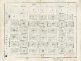
Part is a map of District Lot 69, showing blocks and lots in blocks 12 to 49.
District lot boundaries with the City of Vancouver, British Columbia
Part of City of Vancouver Archives technical and cartographic drawing collection
Item is a map of the City of Vancouver showing district lot boundaries.
Vancouver (B.C.). Engineering Services

District lot boundaries with the City of Vancouver, British Columbia, D.L. map 40
Part of City of Vancouver Archives technical and cartographic drawing collection
Item is a map of the City of Vancouver showing district lot boundaries.
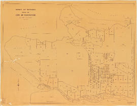
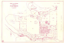
District lot boundaries within the City of Vancouver
Part of City of Vancouver Archives technical and cartographic drawing collection

District lot boundaries within the City of Vancouver, British Columbia
Part of City of Vancouver Archives technical and cartographic drawing collection
Item is an index map to District Lots in Vancouver. Map is designed to be an overlay to index map to sections (item LEG1827.03).

District lot index and street index (1st Avenue to Campbell Avenue)
Part of City of Vancouver Archives technical and cartographic drawing collection
Part contains two pages from the booklet accompanying a guide map of Greater Vancouver.
![D.L. 301 - Ward 8 [location of water pipes and hydrants]](/uploads/r/null/7/b/7b8914ef9132a2e20fa03008daf1a70f3de861b767043aaf338abaeeb42423d7/ce1965c6-6a58-454c-9630-0fcba30688bf-MAP72_142.jpg)
D.L. 301 - Ward 8 [location of water pipes and hydrants]
Part of City of Vancouver Archives technical and cartographic drawing collection
Item is a map showing the location of water pipes and hydrants for D.L. 301, in the area Main Street to Fraser Avenue (Fraser Street) and from 15th Avenue to 25th Avenue (King Edward). Pipes and hydrants are indicated in red ink.
South Vancouver (B.C.). Water Works Department
D.L. 301 - Ward 8 [water pipes and hydrants]
Part of City of Vancouver Archives technical and cartographic drawing collection
Item is a map showing the location of water pipes and hydrants for D.L. 301, from Fraser Avenue (Fraser Street) to Knight Road (Knight Street) and from 15th Avenue to 25th Avenue (King Edward Avenue). Pipes and hydrants are indicated in red ink.
Vancouver (B.C.). Water Works Department
![D.L. [District Lot] 526](/uploads/r/null/c/b/4/cb45fc2541156cf0f1c89b637733e961198017ddd4aa199ba866f1150856a8ba/dfb19024-a115-4097-9258-559e228c275d-MAP332_142.jpg)
Part of City of Vancouver Archives technical and cartographic drawing collection
Item is a portion of a map showing first, second, and third sections of Shaughnessy Heights. Annotations are red lines denoting each of the three stages of Shaughnessy development.
Downtown Peninsula; Vancouver, B.C. Canada; Lines at 100 Foot Intervals; Datum Line 100
Part of City of Vancouver Archives technical and cartographic drawing collection
Item consists of map of downtown Vancouver (possibly using a Planning Department map as a base map) depicting hand-drawn topographic countour lines, possibly created as part of a development application.
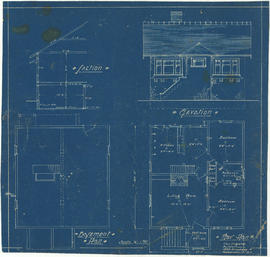
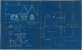
Drawing for unidentified bungalow
Part of City of Vancouver Archives technical and cartographic drawing collection
Item is an architectural drawing, which depicts basement and floor plans, section and front elevation.

Drawing for unidentified bungalow
Part of City of Vancouver Archives technical and cartographic drawing collection
Item is an architectural drawing which depicts basement and floor plans, front elevation and section.
Drawing of J. Lyman Turnbull residence : Lot 14 Blk 798 D.L. 526 (4641 Connaught Drive, Vancouver)
Part of City of Vancouver Archives technical and cartographic drawing collection
Collection contains a photocopy showing floor plans and elevations of the J. Lyman Trumbull residence
Benzie & Bow
Drawing of locks, Second Narrows Dam
Part of City of Vancouver Archives technical and cartographic drawing collection
Map contains two depictions: a plan of the dam and a cross section. Sheet 3 of 3.
Drawings for Blythe Rogers residence [2206 SW Marine Drive]
Part of City of Vancouver Archives technical and cartographic drawing collection
File consists of photostat copies of design drawings for the Blythe Rogers' residence at 2206 S.W. Marine Drive.
B.C. Palmer, Architect
Drawings for Cline Singleton buildings
Part of City of Vancouver Archives technical and cartographic drawing collection
File consists of architectural drawings by various (usually unidentified) architects or designers for the Vancouver builder Cline Singleton. The buildings are both apartment buildings and single family homes, usually modest bungalows.
Drawings for office renovation 1058 Seymour Street
Part of City of Vancouver Archives technical and cartographic drawing collection
File consists of a set or architectural drawings for the renovation and re-purposing of two heritage houses into offices. The drawings include 2 exterior renderings, site and location plans, floor plans, sections and elevations.
Candler, M.
Drawings for unidentified house
Part of City of Vancouver Archives technical and cartographic drawing collection
Drawings of 3737 Oak Street for Faro Holdings Ltd.
Part of City of Vancouver Archives technical and cartographic drawing collection
The file consists of a letter and a Notice of Appeal related to rezoning of a building at 3737 Oak Street. There are also three plans showing the exterior and interior perspective, and the site plan.
Drawings of 718 Granville Street for Henry Birks & Sons
Part of City of Vancouver Archives technical and cartographic drawing collection
File consists of copies of construction drawings for the building.
Drawings of first Vancouver opera house (761 Granville Street)
Part of City of Vancouver Archives technical and cartographic drawing collection
File consists of two distinct sets of architectural drawings depicting the first Vancouver Opera House, located at 761 Granville Street. The first set of drawings, from 1890, appear to relate to the original construction of the building. The 1907 drawings appear to relate to proposed interior renovations.
Canadian Pacific Railway Company
Drawings of proposed sports stadiums in Vancouver parks
Part of City of Vancouver Archives technical and cartographic drawing collection
The file consists of drawings of a proposed sports stadium in Little Mountain Park and a design concept for a civic stadium and auditorium at the southern foot of the Burrard Street Bridge in what is now Vanier Park.
Sharp & Thompson, Architects

Part of City of Vancouver Archives technical and cartographic drawing collection
Part contains a map of East Vancouver Heights showing streets, block numbers and lot numbers, an index map showing the location of East Vancouver Heights in relation to the rest of the city, and text promoting the area.
Part of City of Vancouver Archives technical and cartographic drawing collection
Item is an advertisement for real estate in East Vancouver Heights, with a map of the subdivision and promotional text on one side and an illustrated oblique view of Vancouver on the other.
E.J. Hill's patent boat disengaging gear
Part of City of Vancouver Archives technical and cartographic drawing collection
Item is a drawing outlining the gear mechanism.
Elevation, section and basement plan
Part of City of Vancouver Archives technical and cartographic drawing collection

Enjoyable trips on our interurban lines
Part of City of Vancouver Archives technical and cartographic drawing collection
Part contains text advertising the British Columbia Electric Railway Company's interurban lines.
Part of City of Vancouver Archives technical and cartographic drawing collection
Map shows major highways and zoning in the Greater Vancouver area according to the following: residential, commerical, industrial, civic and institutional, parks and recreational and agricultural.
Existing service stations, retail shopping centres and commercial zoning
Part of City of Vancouver Archives technical and cartographic drawing collection
Item is a map showing the locations of retail shopping centres in Vancouver according to local, district and regional function. Map also shows locations of service stations and commercially zoned areas.
Vancouver (B.C.). Planning Department
Part of City of Vancouver Archives technical and cartographic drawing collection
Item consists of a planning map depicting the Fairview neighbourhood.
Part of City of Vancouver Archives technical and cartographic drawing collection
Item consists of a map depicting the road and rail network around the False Creek basin and Granville Island.
Vancouver (B.C.). Planning Department. Transportation Planning Section

Part of City of Vancouver Archives technical and cartographic drawing collection
Item consists of a planning map depicting the eastern portion of False Creek and surrounding areas.
Part of City of Vancouver Archives technical and cartographic drawing collection
Item is a map of the False Creek basin and surrounding areas, from Granville Street north of False Creek and Fir Street to the west, Main Street to the east, Davie Street to the north and West 6th Avenue to the south. The map notes legal and descriptions of properties in the area depicted.
Vancouver (B.C.). Engineering Services
Part of City of Vancouver Archives technical and cartographic drawing collection
Map is a plan of the Kitsilano Point area showing the area currently known as Kitsilano Beach and Vanier Park, and streets and blocks between Maple Street and Centre Street (Granville Street) and First Avenue to Third Avenue. The plan shows in detail the land designated as the Kitsilano Indian Reserve, including the original reserve as constituted prior to Confederation, the addition made by the Joint Commission on 15th June 1877, and land leased to Harrison Mills T. and T. Co. Map also shows the location of Canadian Pacific Railway land, the Vancouver and Lulu Island Railroad, Rat Portage Lumber Company, Tait's Mill, the Third Avenue Bridge and bathing beach. Annotations in ink indicate the location of Sam Greer's house and garden and nearby spring on what is now known as Kitsilano Beach. A note made on the front of the map by J.S. Matthews in 1930 reads "This blueprint was given me about 1928 by Mrs. J.Z. Hall, dau[ghter] of Sam Greer, and had evidently been attached to a letter from Hon. H.H. Stevens, M.P. to Mr. Greer, dated Ottawa, May 15, 1923 with enclosure from Dr. Scott Indian Office, Ottawa, 9th May 1923. The notation "House" and "Garden" were, when first received by me, on pencil, rudely written, perhaps by Mr. Greer himself (quite and most likely). The marks were inked in with Indian ink by me."

False Creek interim harbour headline
Part of City of Vancouver Archives technical and cartographic drawing collection
Map shows interim and ultimate headline, interim headline, ultimate headline, and existing headline, as well as streets, lots, railway yards and waterfront industries in the False Creek area. Map was created for the "False Creek development" study, "Harbour headline" project.

Part of City of Vancouver Archives technical and cartographic drawing collection
Item is a map showing street names and major landmarks around False Creek during Expo 86. Major pavilions on the fair site are labeled. An index map in the lower right-hand corner of the map shows the location of the primary map in relation to the rest of Greater Vancouver and the United States. The map also includes a short chronology of the history of False Creek and Granville Island. The cover of the envelope depicts a smaller version of the map.
Part of City of Vancouver Archives technical and cartographic drawing collection

Part of City of Vancouver Archives technical and cartographic drawing collection

First Narrows. Proposed Suspension Bridge for Foot Passengers Only
Part of City of Vancouver Archives technical and cartographic drawing collection
Item consists of an architectural drawing for a proposed footbridge over the First Narrows, with its southern end near Prospect Point. The drawing consists of a plan and elevation of the structure. The sheet also includes a location map showing the span of the bridge in the context of Stanley Park and the North Vancouver shoreline.

First Narrows, Burrard Inlet, B.C. showing Parthia and Burnaby shoals
Part of City of Vancouver Archives technical and cartographic drawing collection
Item is a map showing shorelines, estuaries of adjacent creeks, mud flats, tide levels and soundings in feet. Map notes velocity of current at First Narrows.
New Westminster (B.C.). Department of Public Works
![[First section of] Shaughnessy Heights](/uploads/r/null/c/d/0/cd05f96b7e9f01fee4ba2afe83ac83cef9d70b3cf83d3ba8c4ebe5a0a20a429d/0d2ec941-063b-4722-8d84-aff283b273f6-MAP329_142.jpg)
[First section of] Shaughnessy Heights
Part of City of Vancouver Archives technical and cartographic drawing collection
Item is a cadastral map showing lot divisions and in some cases ownership, in Shaughnessy Heights up to January 1st, 1932.
Canadian Pacific Railway Company

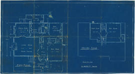
Floor plans for unidentified house
Part of City of Vancouver Archives technical and cartographic drawing collection
Item is an architectural drawing which depicts basement and first floor plans.

Fragment de la carte reduite d'une partie de l'Amerique septentroniale pe le Cap. John Meares 1791
Part of City of Vancouver Archives technical and cartographic drawing collection
Item is a reproduction of a map showing the Pacific coast of North American from the Straits of Juan de Fuca to Prince William Sound. Original map is most likely taken from an atlas or other book.

Fraser River - Annacis Island sheet
Part of City of Vancouver Archives technical and cartographic drawing collection

Fraser River - Deas Island sheet
Part of City of Vancouver Archives technical and cartographic drawing collection

Part of City of Vancouver Archives technical and cartographic drawing collection

Fraser River - New Westminster sheet
Part of City of Vancouver Archives technical and cartographic drawing collection

Fraser River - Port Mann sheet
Part of City of Vancouver Archives technical and cartographic drawing collection