Showing 1835 results

Archival description
City of Vancouver Archives technical and cartographic drawing collection
Print preview View:

1440 results with digital objects Show results with digital objects

Sheet L : Trafalgar Street to Granville Street and Nanton Avenue to Thirty-eighth Avenue
Sheet M : Granville Street to South Cambie Street and Twenty-seventh Avenue to Thirty-eighth Avenue
Sheet N : Musqueam Reserve to Wallace Street and Thirty-eighth Avenue to Forty-ninth Avenue
Sheet O : Holland Street to Elm Street and Thirty-eighth Avenue to Forty-ninth Avenue
Sheet P : Trafalgar Street to Granville Street and Thirty-ninth Avenue to Forty-ninth Street
Sheet Q : Churchill Street to Cambie Street and Thirty-eighth Street to Forty-ninth Avenue
Sheet T : Larch Street to Granville Street and Forty-ninth Avenue to Sixty-first Avenue
Sheet U : Churchill Street to Cambie Street and Forty-ninth Avenue to Park Drive
Sheet X : South West Marine Drive to Ash Street and Fifty-ninth Avenue to Seventy-first Avenue
Sheet V and Z : Milton Street to Heather Street and Seventy-second Avenue to Fraser River ; Angus...
Sheet V and Z : Milton Street to Heather Street and Seventy-second Avenue to Fraser River ; Angus Drive to Granville Street and South West Marine Drive to Fraser River
Sheet S.V. 1 : Cambie Street to Carolina Street and Sixteenth Avenue to Twenty-eighth Avenue
Sheet S.V. 2 : Cambie Street to St. George Street and Twenty-eighth Avenue to Thirty-eighth Avenue
Sheet S.V. 3 : Cambie Street to Prince Edward Street and Thirty-ninth Avenue to Fiftieth Avenue
A sketch design for a nonconformist church
Vest pocket map of Vancouver : map cover
Street index of Vancouver and Lower Mainland
Sheet S.V. 4 : Ash Street to St. George Street and Fifty-first Avenue to Sixty-third Avenue
A student to-day, a citizen tomorrow
Vancouver - the third largest city of the dominion, and Canada's chief Pacific port
Guide map : Vancouver, New Westminster, Burnaby and North Shore municipalities : street index
Conventional signs
Conventional signs
Sheet S.V. 9 : St. George Street to Argyle Street and Fifty-eighth Avenue to Fraser River
Sheet S.V. 8 : Prince Edward Street to Argyle Street and Forty-seventh to Fifty-eighth Avenue
Sheet S.V. 7 : Prince Edward Street to Argyle Street and Thirty-fifth Avenue to Forty-seventh Avenue
Sheet S.V. 6 : Prince Edward Street to Bruce Street and King Edward to Thirty-fifth Avenue
Sheet S.V. 5 : Ash Street to St. George Street and Sixty-third Avenue to Fraser River
Vest pocket map of Vancouver : map A
Indexed guide map of the city of Vancouver and suburbs
Vest pocket map of Vancouver : map C
Vest pocket map of Vancouver : map D
Map of Greater Vancouver
Vest pocket map of Vancouver : map B
Dial map of Greater Vancouver
Map of Fraser Valley
Dial map of Greater Vancouver and suburbs
Map of Lulu Island and Sea Island ; Municipality of Surrey ; Map of Maillardville ; University En...
Map of Lulu Island and Sea Island ; Municipality of Surrey ; Map of Maillardville ; University Endowment Lands
Dial map of Greater Vancouver and suburbs
Map of Burnaby and New Westminster, British Columbia
Map of Greater Vancouver and environs showing principal auto roads and highways
Map of downtown section of Vancouver ; Diagram of New Westminster, B.C., downtown section
Champlain Heights : D.L. 334, group one, N.W.D.
The Canadian Pacific Rockies
Wrigley's new map of Vancouver and Lower Mainland
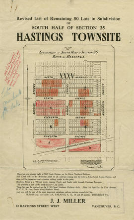
Revised list of remaining 50 lots in subdivision of south half of section 35, Hastings Townsite
Price list of new subdivision : Hastings Townsite, close to city limits
City of Vancouver : Canadian Pacific town site
Visitors map of Vancouver ; world famous Stanley Park ; downtown Vancouver
Visitors map of Vancouver
Results 251 to 300 of 1835