![Fairview, Hodson House Move - 156 [2 of 3]](/uploads/r/null/d/b/d/dbd8ab8d83cde6b11947152c66aaea2c29daac55ef22570fb84672cf900388e6/669842dd-262e-422a-9afe-48da55931b9d-CVA1095-03552_142.jpg)
Fairview, Hodson House Move - 156 [2 of 3]
- COV-S644-: CVA 1095-03552
- Item
- May 1974
Part of City of Vancouver fonds
Fairview, Hodson House Move - 156 [2 of 3]
Part of City of Vancouver fonds
![[2621 St. George Street]](/uploads/r/null/3/d/a/3da9387c7171fa3249b2ca44603ce26db966e0bae25b7be08d01f4590d2ef607/b239f447-b95d-4e79-93ea-9a84d2424ab0-CVA1095-03556_142.jpg)
Part of City of Vancouver fonds
![[2832-2854 St. George Street]](/uploads/r/null/9/a/5/9a5c8bd4d835ec1132c54384e0a32eb2e0a9b905b02399aa84bdc43eef4b5ecc/899783ea-a8e6-4f9e-81bb-a40e4df34673-CVA1095-03557_142.jpg)
Part of City of Vancouver fonds
![[2843 St. George Street]](/uploads/r/null/6/f/9/6f95599524b46f7bae3bbc71f14473d2af4d7bd69f17e3b2a98764cf1f4fb0db/ad364c90-8971-4f7c-bf8e-3d29840a263a-CVA1095-03558_142.jpg)
Part of City of Vancouver fonds

Part of City of Vancouver fonds
![[260 East 11th Avenue]](/uploads/r/null/0/5/e/05e34733a6fb78800804ddb977be8726886bbca50379feec2cf23ed25fc92c73/889d173e-1fce-404b-8cbd-eae04c237ef3-CVA1095-03582_142.jpg)
Part of City of Vancouver fonds
![[1118 East 12th Avenue]](/uploads/r/null/6/4/5/645eb56389b0806d9c9e0bd131162e5bc157f3986bea1e7f78cff8e4b3368ed2/d899dbbd-4563-4bec-a422-1e123634df51-CVA1095-03584_142.jpg)
Part of City of Vancouver fonds
![[1122 East 12th Avenue]](/uploads/r/null/1/5/7/1575c6c17608e22e477f62717051797ff0af423fb355b8521f4c19e9561987c5/328cf8ea-218d-4fb0-a9a3-668e237b3619-CVA1095-03585_142.jpg)
Part of City of Vancouver fonds
![[1128 East 12th Avenue]](/uploads/r/null/4/9/4/49418767df19870485ce7ccd3e58b853f7ec832272d3948003c8f667ad25a937/4e69832f-e3a7-41b9-8c79-3f1587f8a499-CVA1095-03595_142.jpg)
Part of City of Vancouver fonds
![[1134 East 12th Avenue]](/uploads/r/null/c/e/4/ce49dac7efd173a100a3b17fa036b8b45bc257a124725ade4daa54a5b8d62c6a/b849a311-769d-4c5d-b667-541ab3084bf3-CVA1095-03597_142.jpg)
Part of City of Vancouver fonds
![[1246 East 12th Avenue]](/uploads/r/null/c/9/8/c984ed199db8d187a60707db5399f2029a4cac13a73ddb07c09fe7c015afc9a7/8a4c6b24-2dbb-46d6-8206-ed0d1ac7c937-CVA1095-03603_142.jpg)
Part of City of Vancouver fonds
![[266 East 4th Avenue]](/uploads/r/null/d/4/6/d46ccf27ba8a1aa893c200ff8d1e08db42b27ccc9fde44e7e2e29db43d203190/5a55f8bd-27ac-4b5d-b1c6-09369d849efb-CVA1095-03610_142.jpg)
Part of City of Vancouver fonds
![[265 East 4th Avenue]](/uploads/r/null/6/0/8/60876b6c8709fa3d7d6da1e2b78f25268c4ca368b05fd718875f474bc2e717ec/29d9aaf6-3fec-481c-9baa-01a025f211e1-CVA1095-03611_142.jpg)
Part of City of Vancouver fonds
![[273 East 4th Avenue]](/uploads/r/null/4/3/2/432be73f3c61a0de324cfea4643a7f75c0eeb54495c1d5ad3d8db3f192bd0354/ff3481fc-87c0-4f33-bebb-b9aadbffac60-CVA1095-03618_142.jpg)
Part of City of Vancouver fonds
![[824 East 7th Avenue]](/uploads/r/null/c/e/e/ceed8847e310f533557126f790778123d0e3239dd1e5d02f8d798b98ab943b01/0c112bb7-5ad4-418e-b22a-0306a6a45184-CVA1095-03657_142.jpg)
Part of City of Vancouver fonds
![[116 East 15th Avenue]](/uploads/r/null/1/9/3/193ed839ba67ba82941b99b91c709080bdd7672e106adc4df7ec4a400581dde5/178a68d5-6d22-419d-a889-fd00c237f1f5-CVA1095-03659_142.jpg)
Part of City of Vancouver fonds
![[848 East 7th Avenue]](/uploads/r/null/e/1/b/e1b1fcc0b293e271a649d2b9685f10e2accf26ad809e0abbba57e1036368430d/d793bf44-6ac4-47a7-adf2-236f88f53ab4-CVA1095-03674_142.jpg)
Part of City of Vancouver fonds
![[863 East 7th Avenue]](/uploads/r/null/8/d/0/8d0f545df2dfb2262de24f6700e134b59c0e3f6f6383a62899e48304e5992a6d/2527639f-bb1d-4542-8a5e-c56f3df7c205-CVA1095-03677_142.jpg)
Part of City of Vancouver fonds
![[154 East 10th Avenue - Holy Trinity Ukrainian Orthodox Cathedral, 2 of 5]](/uploads/r/null/1/c/0/1c0e10c3ea4369ab1c298069e1f4d694d18b756e4bfd8d4f94f73b6f97ffa6eb/7d42e70e-3c27-49f9-a54d-44d3e0009b1a-CVA1095-15421_142.jpg)
[154 East 10th Avenue - Holy Trinity Ukrainian Orthodox Cathedral, 2 of 5]
Part of City of Vancouver fonds
![[Skateboard park]](/uploads/r/null/9/5/9500096098870fb8d827610ab03f141dd0bf01c45d617caa544e87f330285c6d/70798748-0df3-4d88-8398-cf1cc534a489-A69849_142.jpg)
Item is a photograph showing the China Creek Skateboard Park.
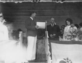
Mayor McGeer presents oldest gentleman inhabitant of Mt. Pleasant
![Mount Pleasant [House detail]](/uploads/r/null/9/8/6/986eeed4057a6ae35267db6661a44e8ff99365a4bb3117da658fb3a37003de43/9c44c251-6a79-4f4c-9d27-33583d165910-CVA1095-12874_142.jpg)
Part of City of Vancouver fonds
![Mount Pleasant [Adjacent detached houses]](/uploads/r/null/3/5/4/354ea7618c4bcb48d709cf4a9617a2266ff1b5f3d55e1b5f4df8f84a350c000b/2f7f1848-c775-4752-b822-0e75214ba4ab-CVA1095-12875_142.jpg)
Mount Pleasant [Adjacent detached houses]
Part of City of Vancouver fonds
![Mount Pleasant [Detail of house at 185]](/uploads/r/null/5/9/9/59980b877f8f7af3a5b313b80d269b229df321166ef06ec1ab3935fb5b19bce2/c8cecad4-15e2-4a6c-805e-242659b0a52d-CVA1095-12893_142.jpg)
Mount Pleasant [Detail of house at 185]
Part of City of Vancouver fonds
![[453 West 12th Avenue - City Hall, 2 of 8]](/uploads/r/null/5/e/d/5ed54e6c6129172ca8e45a48bfb7c2f5c1d6313d538622f19dbba5bfc6448c63/ae64173b-9041-4d69-b408-65149f0d6261-CVA1095-13148_142.jpg)
[453 West 12th Avenue - City Hall, 2 of 8]
Part of City of Vancouver fonds
![[453 West 12th Avenue - City Hall, 8 of 8]](/uploads/r/null/6/5/8/658bf7f18a67509018f037860124e4500af15853c3731b896c3ecdf75f30d192/d0297f7f-ee2c-44ac-b38a-43f6baca78ff-CVA1095-13154_142.jpg)
[453 West 12th Avenue - City Hall, 8 of 8]
Part of City of Vancouver fonds
![[166 West 10th Avenue, 2 of 6]](/uploads/r/null/0/6/9/069aa808da1d6669a18634d367376f8660aa5cf70d53f6c1f643753b51b39f47/d63dc82a-376d-4f19-81b7-8bfd4c3ee8d5-CVA1095-13665_142.jpg)
[166 West 10th Avenue, 2 of 6]
Part of City of Vancouver fonds
![[166 West 10th Avenue, 4 of 6]](/uploads/r/null/6/5/1/6511c3fb74bfc55173b31642748de749f3f1c59706b468860d8b91c2a61d7d0e/2ed34ad2-945b-4888-92cb-648306eeb350-CVA1095-13667_142.jpg)
[166 West 10th Avenue, 4 of 6]
Part of City of Vancouver fonds
![[166 West 10th Avenue, 5 of 6]](/uploads/r/null/5/3/3/5335e1668268a68a90ef06ad67e95ef3e28b9868ae47c362bb5e03ecb2eb2a1c/377624af-b86a-4e50-ac80-0d4f4dd0cadf-CVA1095-13671_142.jpg)
[166 West 10th Avenue, 5 of 6]
Part of City of Vancouver fonds
![[166 West 10th Avenue, 6 of 6]](/uploads/r/null/2/6/b/26b2bc9e838b01b6e702c298d57a1a8b135e1962eadff5015f0b01c33b250386/9d5e9628-e4e6-401e-9eab-f94d5739f42d-CVA1095-13672_142.jpg)
[166 West 10th Avenue, 6 of 6]
Part of City of Vancouver fonds
![[453 West 12th Avenue - City Hall, 4 of 5]](/uploads/r/null/0/c/3/0c3414093fb3cbee3b87c58d043857d5e445c9d71844a1ea24901ce21b12adeb/ba29185c-6bf9-4708-9735-4c58ee1094ec-CVA1095-13706_142.jpg)
[453 West 12th Avenue - City Hall, 4 of 5]
Part of City of Vancouver fonds
![Vancouver, B.C. Plan showing location of water pipes, hydrants, etc. [Fairview slopes]](/uploads/r/null/6/9/69e0d6904facfa2a814069c15122fba46fc4d8077bff76402e95484a4b13d4d8/313b8940-1e98-45d4-b077-abe0f6bee66a-MAP72_142.jpg)
Vancouver, B.C. Plan showing location of water pipes, hydrants, etc. [Fairview slopes]
Part of City of Vancouver Archives technical and cartographic drawing collection
Item is a map showing the location of water pipes and hydrants for the area bounded by Scotia Street, False Creek, Spruce Street and Tenth Avenue (D.L. 526, D.L. 302 and D.L. 200). Block 6 in D.L. 200 was covered by an overlay depicting a later sub-division. Pipes and hydrants are shown in various coloured inks to indicate installation date. Annotations have been drawn on a base map that was part of a larger map.
Vancouver (B.C.). Water Works Department

Part of City of Vancouver Archives technical and cartographic drawing collection
Item consists of a large scale site plan, depicting a proposed development in False Creek [Expo 86?] annotated on top of what appears to be a City planning map. The plan appears to depict part of the Concord Pacific development.
![[636 East Broadway]](/uploads/r/null/9/0/d/90d8a2160b0420845553208bdc8e02e2388438e4e610f8895f1e9bdd8d08af3d/24defc83-0f2b-40ff-bfd8-c3b5bc9c92ab-CVA1095-01607_142.jpg)
Part of City of Vancouver fonds
![[753 East 8th Avenue]](/uploads/r/null/0/9/3/093450ff6f720a8ce7c415be9c699c9e0798561863f4ba022e872ea9ad31bb58/51528c06-32e4-49d1-82eb-fd053c045a6a-CVA1095-01618_142.jpg)
Part of City of Vancouver fonds
![[530 East 8th Avenue]](/uploads/r/null/8/0/2/8027b5a773931c2195cb14cfd174858f93a71813a439be92a01d8cc4f7cb0a05/8589045e-9251-467f-aa85-b54b65e7d3ec-CVA1095-01630_142.jpg)
Part of City of Vancouver fonds
![[536 East 8th Avenue]](/uploads/r/null/d/3/e/d3e6ab6a8db81708b5d81737a10a4c713464d77fc055d18645b13c4f3442640c/04a6a45d-6965-4df4-858d-e4381475fd82-CVA1095-01631_142.jpg)
Part of City of Vancouver fonds
![[545-547 East 8th Avenue]](/uploads/r/null/0/3/e/03e7e1238fc7597086d08d3e8da68cee5119a1d30bf515f5c41d6942fd411a53/3cec7523-0ca1-4bf2-a6bd-370d33c65f30-CVA1095-01633_142.jpg)
Part of City of Vancouver fonds
![[550 East 8th Avenue]](/uploads/r/null/c/9/8/c982349da144d66888b381c5cf4941e54cb6ae2efcca739e8ba604f16f123880/55439843-84dd-448a-8934-0aaa8668510a-CVA1095-01634_142.jpg)
Part of City of Vancouver fonds
![[830 East 8th Avenue]](/uploads/r/null/1/4/f/14f079d5a68a146149750f6228b88a672d2c01d185dcf65bbc3f9a502a80aa41/4009e323-f091-4668-bc27-f0f80f1b92af-CVA1095-01638_142.jpg)
Part of City of Vancouver fonds
![[832 East 8th Avenue]](/uploads/r/null/3/6/5/36502e984ce0376e7c2047060f68859e64ae07fafd152a328081ec99acd4b389/16e3a50a-050c-46f6-8819-76636a2dfb21-CVA1095-01639_142.jpg)
Part of City of Vancouver fonds
![[838 East 8th Avenue]](/uploads/r/null/1/5/b/15b082d978c3bcbf3fa870d5c278c26d1201dab956cac29102d69b441f7cec15/5808016d-b976-432e-bbf8-9d6407e1c56b-CVA1095-01640_142.jpg)
Part of City of Vancouver fonds
![[Heritage inventory photographs - 103, 4 of 7]](/uploads/r/null/3/c/0/3c0d0144eb9b21369ff58b0d4df7cc3213a348e61dff00f0ee7875be73d139c2/cd436729-5304-4c42-8bac-5125bb1ab7e5-CVA1095-01642_142.jpg)
[Heritage inventory photographs - 103, 4 of 7]
Part of City of Vancouver fonds
![[Heritage inventory photographs - 103, 6 of 7]](/uploads/r/null/b/d/3/bd35e309c2f396a20586bdce6c6e34070a7a04ce182b34623731ece066cf110c/e3097f84-8a60-45c9-8c0e-59e886da3451-CVA1095-01644_142.jpg)
[Heritage inventory photographs - 103, 6 of 7]
Part of City of Vancouver fonds
![[Heritage inventory photographs - 103, 7 of 7]](/uploads/r/null/7/4/4/74449acf85fad2b642c89b5c8f692ba50fa793d2aab592936e49e27febd3271b/29fc2ad0-4886-4c9f-a00c-97f6bba27f91-CVA1095-01645_142.jpg)
[Heritage inventory photographs - 103, 7 of 7]
Part of City of Vancouver fonds
![[654 East 7th Avenue]](/uploads/r/null/a/a/e/aaeded0021a7783fc1e846ddf052a577729a6193c83582a740f4747ad4d4c7a5/ea441209-9291-45b5-9d22-3758da082560-CVA1095-01646_142.jpg)
Part of City of Vancouver fonds
![[508 East 7th Avenue]](/uploads/r/null/a/b/1/ab1a7b90c481edf3dbd0fd8622d63cd121d75dc4eef60fd40909bf9078fa01f0/17c4c0c6-32ea-47ec-a4d3-fdcbde3e445e-CVA1095-01660_142.jpg)
Part of City of Vancouver fonds
![[Intersection of East 7th Avenue and Quebec Street]](/uploads/r/null/9/f/a/9fab91d72bc6be756e3d3070b6f89659c5bb987efc228530754b740242bcc406/c96631bd-7805-44ed-a052-2786559e0df4-CVA1095-01663_142.jpg)
[Intersection of East 7th Avenue and Quebec Street]
Part of City of Vancouver fonds
Item is a photograph that depicts the intersection of East 7th Ave. at Quebec St. Visible is Quebec Manor, located at 101 East 7th Ave.
![[848 East 7th Avenue]](/uploads/r/null/5/7/3/573f24df6d3ad656bfed3de08de36b3436fe6bfefdfac7f4591d5f4738465fed/a931799d-1e76-4c54-98a5-0159c6895fa7-CVA1095-01667_142.jpg)
Part of City of Vancouver fonds
![[Heritage inventory photographs - 104, 10 of 13]](/uploads/r/null/8/5/7/857d4d6fb0c4a68d0989bce023d972f6891334a5582a765876179822328c8b4b/d8b0c19e-340c-4df5-986d-e535661c2765-CVA1095-01672_142.jpg)
[Heritage inventory photographs - 104, 10 of 13]
Part of City of Vancouver fonds