Insurance plan of Vancouver, British Columbia. Volume two
Index to streets and block numbers
Plate 106 [Manitoba Street to Dufferin Street to Alberta Street to Fifth Avenue]
Plate 115 [Scotia Street to Fifth Avenue to Quebec Street to Eighth Avenue]
Plate 117 [Carolina Street to Seventh Avenue to Victoria Drive to Tenth Avenue]
Plate 138 [Block east of Maple Street to York Street to Arbutus Street to Third Avenue]
Plate 143 [Maple Street to Third Avenue to block west of Arbutus Street to Sixth Avenue]
Plate 146 [Block east of Fir Street to Third Avenue to Pine Street to Sixth Avenue]
Plate 147 [Hemlock Street to False Creek to block west of Granville Street to Sixth Avenue]
Plate 152 [Block east of Fir Street to Sixth Avenue to Pine Street to Ninth Avenue]
Plate 156 [Block east of Oak Street to Sixth Avenue to Spruce Street to Ninth Avenue]
Plan of provincial government property being a portion of townsite of Vancouver and sub-division of lot 540, group 1, New Westminster District, B.C., to be sold by public auction at Vancouver, B.C.
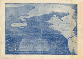
Plan of Vancouver Harbour and False Creek, Vancouver, B.C., showing proposed improvements as outlined in Jos. R. Roy's reports dated 15th Sept. 1906
Map of portion of New Westminster District with adjacent islands and part of Vancouver Island
Plan of provincial government property being a sub-division of a portion of expired timber lease situated in North Vancouver, New Westminster district, B.C., to be sold by public auction
Plan of sub-division of lot 2027, group 1, New Westminster District, B.C., to be sold by public auction at Vancouver, B.C.
Index plan of provincial government lands to be sold at auction at Vancouver B.C. November 20, 1906
![Plate 114 [Quebec Street to Fifth Avenue to Manitoba Street to Eighth Avenue]](/uploads/r/null/1/d/a/1da8c667b11d0f463073015a74cdc6f409f2f18733a36abda9afe0b996d9abe6/02c6dfe0-25c2-4696-8ff5-429480c2de74-1974-100_142.jpg)
![Plate 120 [Manitoba Street to Eighth Avenue to Alberta Street to Eleventh Avenue]](/uploads/r/null/f/a/6/fa6302e459598f703ec9a4f6d49de458a312194cf71a4d02ffaeb7416336e184/73a06efd-6ff6-4712-86d3-99cef6e5d4f3-1974-100_142.jpg)
![Plate 126 [Block east of Westminster Road, to Eleventh Avenue to Quebec Street to Fourteenth Avenue]](/uploads/r/null/c/f/c/cfc0873d3a7b7370676e1fe47a0b3d7a1c1548fcc9f956684126904f28b3eab1/90c52799-da7f-49d6-8ea9-96653757bd78-1974-100_142.jpg)
![Plate 127 [Victoria Drive to Eleventh Avenue to Sophia Street to Fourteenth Avenue]](/uploads/r/null/8/0/1/8015ddcd6ee093727af89d8411f527c5942313bf9477353bf2cb54ffde758a42/ec3257e4-b725-430e-9f32-98e02e541fc9-1974-100_142.jpg)

![Plate 139 [Cedar Street to York Street to block west of Cypress Street to Third Avenue]](/uploads/r/null/1/6/8/16834cc0833e75a965d75cb28e98aed82386baa4a3dd16adfb2214fb7784e6de/996a3797-d9a1-4d7e-85ec-026ef449eb72-1974-100_142.jpg)
![Plate 145 [Pine Street to Third Avenue to block west of Cedar Street to Sixth Avenue]](/uploads/r/null/6/e/d/6edf28481ccf2f8c292cafc7d295d8dc5f0f8a4df775363d1a834454503f7457/054c1f34-de8e-4f3c-95c6-cd44be0a9257-1974-100_142.jpg)
![Plate 148 [Yew Street to Sixth Avenue to Vine Street to Ninth Avenue]](/uploads/r/null/1/6/d/16d2ce9f2af7c7c7d0e0d3b10d0236d78460c38de3f1503704b5af9f8b1c1577/b8c5b1ec-4d07-415e-b3c6-fb3fda7febbc-1974-100_142.jpg)
![Plate 153 [Hemlock Street to Sixth Avenue to block west of Granville Street to Ninth Avenue]](/uploads/r/null/0/a/b/0abee4f6ab9261fdd6d4c93bc35e4a02bc8fdc3f6b17439c7a8d92cd560ff491/09319ade-296b-4282-bb2c-e7963da06d6d-1974-100_142.jpg)
![Plate 159 [Bridge Street to Sixth Avenue to block west of Ash Street to Ninth Avenue]](/uploads/r/null/e/4/4/e44f57cba6b38fa8da6ef44cbb61be076fcf20c0156c0ae088cd88ac1c2d7de9/41ef2962-f94b-4a03-853d-b6e743b5c09f-1974-100_142.jpg)
![Plate 162 [Bridge Street to Fourteenth Avenue to Heather Street to Seventeenth Avenue]](/uploads/r/null/5/2/5/5256cff8242defeed25de4521f059690bd7ac034661f9e0b1d3a1d3531ed3d68/6f5bb597-8fce-40e1-bc4f-2ec474b293f1-1974-100_142.jpg)

![Plate 106 [Manitoba Street to Dufferin Street to Alberta Street to Fifth Avenue]](/uploads/r/null/a/2/8/a288bcdc881a84d269c058cb38c117c43ef34c68d4a36dd1ffa72bfc2a46ba60/2d5baff6-456c-4406-9faf-fdd562e492b0-1974-100_142.jpg)
![Plate 115 [Scotia Street to Fifth Avenue to Quebec Street to Eighth Avenue]](/uploads/r/null/b/8/6/b86c99928da0cefb46e6dc6e7d9b2f9feb0c5d75b13cbfacf0da89c0e212870c/10e20065-c9ef-41ad-a820-8e3c418d2043-1974-100_142.jpg)
![Plate 117 [Carolina Street to Seventh Avenue to Victoria Drive to Tenth Avenue]](/uploads/r/null/f/0/1/f01e37963864f5231283cc4e6bc7df6cd6d6df44667846c5e69dc6787c623881/1797e915-b1a7-4980-acf1-b42faefa128c-1974-100_142.jpg)
![Plate 138 [Block east of Maple Street to York Street to Arbutus Street to Third Avenue]](/uploads/r/null/6/9/2/692f296ac23d1ac9b6172d0c655bd72dab24b5d54f685fe841fee63caf544f0d/1d2fa9e3-9b76-4de1-93ae-5ab487d1eee6-1974-100_142.jpg)
![Plate 143 [Maple Street to Third Avenue to block west of Arbutus Street to Sixth Avenue]](/uploads/r/null/0/e/a/0ea98fd76cb501aabd4ab7f104a05849e09062d7e588acf3aed4242cf3e622b8/6d85924e-f159-40bc-95ae-6c991ff3b2c9-1974-100_142.jpg)
![Plate 146 [Block east of Fir Street to Third Avenue to Pine Street to Sixth Avenue]](/uploads/r/null/f/5/f/f5f0590ecf8724bfa6c9f2bcff56c118991a327bd55de2e5ce81b9a5dd964194/a512e8de-7c29-40ef-8a86-92ec8f6717bb-1974-100_142.jpg)
![Plate 147 [Hemlock Street to False Creek to block west of Granville Street to Sixth Avenue]](/uploads/r/null/a/b/d/abd13a3749032aa33979a67cba7062ed3cf112839e13bafb0eee601ec40fc955/30faa6e3-9576-4383-9326-89c314adf9cd-1974-100_142.jpg)
![Plate 152 [Block east of Fir Street to Sixth Avenue to Pine Street to Ninth Avenue]](/uploads/r/null/9/3/6/93607ace79536cc9ba73482f1f25a28f8b7cd33c40d6117463d7190a5cd58cab/33eb584e-3f39-41a1-adb0-c3d2f0a2ef0b-1974-100_142.jpg)
![Plate 156 [Block east of Oak Street to Sixth Avenue to Spruce Street to Ninth Avenue]](/uploads/r/null/f/8/1/f81307f079a5ed18bb6e49affd7a5f3d3100e9ba3238d592691d04ffeda95499/cad8edde-d5d0-4c5c-b0f8-93ec688a9cb6-1974-100_142.jpg)


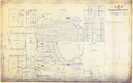
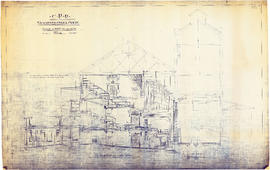
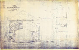
![CPR Vancouver Opera House elevation to Farrell apartment building [south]](/uploads/r/null/a/5/d/a5d0b51f5ebdb12f52ebe4d7b4789fdeba6d42de6c545267e9cc245f6f760007/f58c68f3-d53f-4433-b4a9-9e9510f429c5-1989-20_142.jpg)

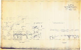
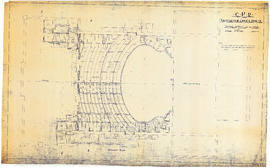
![CPR Vancouver Opera House elevation to hotel [north]](/uploads/r/null/f/d/3/fd36e9463c257d654596ac0175eda976e793e46e728364441848badc37ba1faf/cd3849c0-8d60-4452-a85c-b4457d6509b1-1989-20_142.jpg)