![Plate 110: Sunset [Windsor Street - River Avenue - Ontario Street - Fraser River]](/uploads/r/null/0/5/1/0517315aa9f84af3bc4f564f523aaf9e067d9b2cd00a4aa1ae4c0fdeafa3e930/1c54d499-8d65-47ea-8942-f6a78a82a9ae-MAP342b_142.jpg)
Plate 110: Sunset [Windsor Street - River Avenue - Ontario Street - Fraser River]
![Plate 113: Killarney [Park Street - Sixty-seventh Avenue - Rupert Street - Fraser River]](/uploads/r/null/d/c/6/dc6f37ebae27a37b14cb5b18025ffac1646066b421e01663f748b244aca25200/8c3aa04a-1f90-4780-a260-048c78490ec5-MAP342b_142.jpg)
Plate 113: Killarney [Park Street - Sixty-seventh Avenue - Rupert Street - Fraser River]

Vancouver Harbour, British Columbia

North-east False Creek Map
![The Seechelt [Sechelt] Forest](/uploads/r/null/e/6/d/e6d1e8d1a7613c8e7ce050434f42ef80f8e00ca339edc6e23dc578f9a4154957/c9ad5fbf-94a8-4925-8b43-b0845d5bd699-MAP54_142.jpg)
The Seechelt [Sechelt] Forest
Plan of South Shore, Burrard Inlet between Granville and Heatley Avenue
Plan of South Shore, Burrard Inlet between Granville and Heatley Avenue
Plan of South Shore, Burrard Inlet in front of lots 214 and 215 [Burnaby]
Plan of South Shore, Burrard Inlet in front of lots 214 and 215 [Burnaby]
Plan of South Shore, Burrard Inlet in front of lot 203 [Port Moody]
Plan of South Shore, Burrard Inlet in front of lot 203 [Port Moody]
Plan of North Shore, Burrard Inlet between D.L. 349 and D.L. 226
Plan of North Shore, Burrard Inlet between D.L. 349 and D.L. 226
Plan of North Shore, Burrard Inlet in front of D.L. 611-469 and I.R. No. 3
Plan of North Shore, Burrard Inlet in front of D.L. 611-469 and I.R. No. 3
Plan of North Shore, Burrard Inlet between Fell Avenue and St. Andrews
Plan of North Shore, Burrard Inlet between Fell Avenue and St. Andrews

Sheet 1 : Boundary Road to Burrard Inlet to Templeton Drive to Charles Street
Sheet 4 : Boundary Road to 24th Avenue to Victoria Drive to Forty-ninth Avenue
Sheet 6 : Penticton Street to Burrard Inlet to Princess Avenue to William Street
Sheet 12 : Prince Albert Street to East Seventeenth Avenue to Laurel Street to East Twenty-ninth Avenue

Sheet 14 : Prince Albert Street to Forty-ninth Avenue to Laurel Street to Kent Avenue
Sheet 17 : Oak Street to Connaught Street to Elm Street to West 50th Avenue

Sheet 23 : Vine Street to Forty-first Avenue to Salish Drive to Fraser River

Sheet 28 : Main Street to Twenty-ninth Avenue to Granville Street to Fiftieth Avenue

Great Northern Railway. Map of the United States
Granville Street
Granville Street

Stuart's pocket map of Vancouver, B.C.

Plan showing lands occupied in Stanley Park near Brockton Point. City of Vancouver B.C.
![[Cross sections of ocean floor between Vancouver Island and mainland of British Columbia]](/uploads/r/null/c/a/6/ca687b43e46696a0c1d9223ef1e80ebe50bba0ea48092c458b525fc90f7b517c/7d458083-64ae-4682-be03-8fd1211e38c9-MAP8b_142.jpg)
[Cross sections of ocean floor between Vancouver Island and mainland of British Columbia]
Plan showing proposed location of pressure tunnel, shafts, and connecting pipe lines at First Narrows, Burrard Inlet, Vancouver, B.C.
Plan showing proposed location of pressure tunnel, shafts, and connecting pipe lines at First Narrows, Burrard Inlet, Vancouver, B.C.
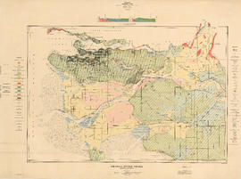
Fraser River Delta, British Columbia
![[Sheet 65 : Camosun Street to Carnarvon Street and Forty-first Avenue to Thirty-third Avenue]](/uploads/r/null/4/0/407c98f21cf3d2ce519b79e8a505fd6a325c965dc1550cdbc00d96b7bc7e5e3d/04862e6e-5125-4593-84de-c80135fd76ce-MAP339_142.jpg)
[Sheet 65 : Camosun Street to Carnarvon Street and Forty-first Avenue to Thirty-third Avenue]
![[Sheet 78 : Kerr Street to Ivy Avenue and North Arm of Fraser River to Southeast Marine Drive]](/uploads/r/null/9/0/90c6186a1aa17588ec162078d412440a826f55dc10a9d49f8e74df97a4d3ff6e/0a3e4f49-3d6d-4dec-95f1-08aa42e666d8-MAP339_142.jpg)
[Sheet 78 : Kerr Street to Ivy Avenue and North Arm of Fraser River to Southeast Marine Drive]

[Sheet 82 : Main Street to Tipping Road and Crompton Street and Twigg Island to Southeast Marine Drive]
![[Sheet 83 : Fremlin Street to Main Street and Southwest Marine Drive to Fifty-seventh Avenue]](/uploads/r/null/3/e/3efc869894db6ec7c88cf96b10cd2cb7f93db04cae7e1f6f35be1ac51c2bdc14/6323fdeb-3ce2-4794-bc7f-691ce81ee431-MAP339_142.jpg)
[Sheet 83 : Fremlin Street to Main Street and Southwest Marine Drive to Fifty-seventh Avenue]
[Sheet 84 : Laurel Street to Main Street and North Arm of Fraser River to Southwest Marine Drive]
[Sheet 84 : Laurel Street to Main Street and North Arm of Fraser River to Southwest Marine Drive]
![[Sheet 86 : Angus Drive to Laurel Street and Seventy-fifth Avenue to Sixty-seventh Avenue]](/uploads/r/null/6/e/6efd95dacdad7f8976575767597855d90ccaa34e423b1ba76885d33d2dffb725/8167b0a2-0792-4e60-9755-7a4706830df0-MAP339_142.jpg)
[Sheet 86 : Angus Drive to Laurel Street and Seventy-fifth Avenue to Sixty-seventh Avenue]
![[Sheet 88 : Macdonald Street to Angus Drive and Edgington Avenue to Fifty-seventh Avenue]](/uploads/r/null/5/9/595b991e091f624b5f74507db063dddb150624fbef03fe1d577f8d7a32bb9088/8afa1350-f31b-43bd-a14f-0ea9082c21fe-MAP339_142.jpg)
[Sheet 88 : Macdonald Street to Angus Drive and Edgington Avenue to Fifty-seventh Avenue]
[Sheet 90 : Carrington Street to Macdonald Street and Richmond to Celtic Avenue]
[Sheet 90 : Carrington Street to Macdonald Street and Richmond to Celtic Avenue]
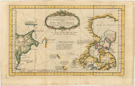
Carte reduite des parties septentrionales du globe, situees, entre l'Ansie et l' Amerique, pour fervir a l'histoire generale des voyages

Vancouver

City of Vancouver, British Columbia
Fraser River and Burrard Inlet
Fraser River and Burrard Inlet
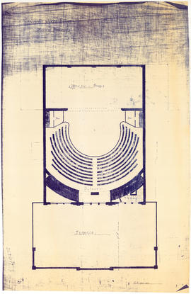
Vancouver Opera House plan of balcony

Vancouver Opera House plan of gallery

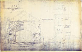
Vancouver Opera House transverse section
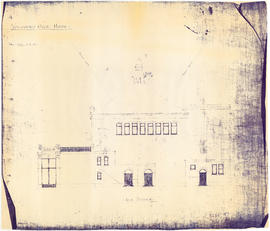
Vancouver Opera House side elevation
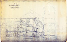
CPR Vancouver Opera House longitudinal section
CPR Vancouver Opera House sections A-A and B-B
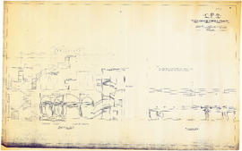
CPR Vancouver Opera House transverse section and basement plan

CPR Vancouver Opera House trusses for gallery and balcony

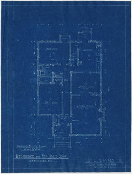
Ground floor plan
Front elevation
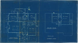
First and second floor plans

First floor plan