
- PUB-: PD 2134-: LEG1376.10
- Part
- [ca. 1980]
Part of City publications collection
11112 results with digital objects Show results with digital objects
Part of City publications collection


Part of City publications collection


Part of City publications collection

Part of City publications collection
Part of City publications collection
Part of City publications collection

Part of City publications collection
Part of City publications collection

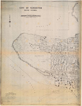
City of Vancouver, British Columbia : Cypress Street to Boundary Road
Part of City publications collection
Part is the east half of a map of Vancouver showing streets, address block numbers, parks, schools, golf courses, First Nations reserves, railways, and topographic contour lines.
City of Vancouver, British Columbia : Point Grey to Cypress Street
Part of City publications collection
Part is the west half of a map of Vancouver showing streets, address block numbers, parks, schools, golf courses, First Nations reserves, railways, and topographic contour lines.


Part of City publications collection

Part of City publications collection

Part of City publications collection

Part of City publications collection

Part of City publications collection

Part of City publications collection

Part of City publications collection

City of Vancouver, B.C. area map : Inverness Street to Boundary Road and 32nd Avenue to 54th Avenue
Part of City publications collection

Part of City publications collection

Part of City publications collection

City of Vancouver, B.C. area map : Maple Street to Heatley Avenue and Burrard Inlet to 6th Avenue
Part of City publications collection
![Zoning map : City of Vancouver, British Columbia [verso]](/uploads/r/null/0/c/0c28eac99426ce4ba64e4dfd48e45082c152014d6316047710a9601978663e70/d7052696-ccd5-4643-98d6-5e29205d9903-PD2100_142.jpg)
Zoning map : City of Vancouver, British Columbia [verso]
Part of City publications collection
Item component isthe verso of a Vancouver zoning map 1998 containing a brief description of the intent of the zoning districts schedules.
![Zoning map : City of Vancouver, British Columbia [front side]](/uploads/r/null/c/6/c61049cff53ecb5ec71dcc9b9de797d324126efb9c99b5eb62ea91c42d3b6842/743a013c-68a0-418f-8c6a-fd776aa116ef-PD2100_142.jpg)
Zoning map : City of Vancouver, British Columbia [front side]
Part of City publications collection
Item component is the front side of a zoning map showing different zoning districts of Vancouver in 1998.
![Zoning map : City of Vancouver, British Columbia [verso]](/uploads/r/null/8/e/8e44e80ba947d96b0a59a2bf4a48b60a1421fd04ba8480ddd13d7d13d0702e36/6b887f4f-8b76-48e2-866b-15499f569972-PD2100_142.jpg)
Zoning map : City of Vancouver, British Columbia [verso]
Part of City publications collection
Item component is the verso of the map containing a brief description of the intent of the zoning districts schedules.
![Zoning map : City of Vancouver, British Columbia [front side]](/uploads/r/null/d/f/df6282b6329852b263c3d33e20d903e4289eec05fde21bd58597f62d30789dde/225b2095-0e64-4986-878c-fd99eb6e1f18-PD2100_142.jpg)
Zoning map : City of Vancouver, British Columbia [front side]
Part of City publications collection
Item component is the front side of the map showing different zoning districts of Vancouver in 1993.

Vancouver Parks and Recreation : map and guide
Part of City publications collection
Part contains a map of Vancouver showing major roadways and locations of attractions advertised in the pamphlet, a map of Stanley Park in more detail, and textual information on Stanley Park and Vancouver beaches.
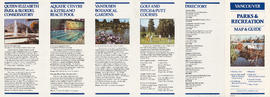
Vancouver Parks and Recreation : map and guide
Part of City publications collection
Part contains information about Vancouver attractions including Queen Elizabeth Park, the Vancouver Aquatic Centre, VanDusen Botanical Gardens, and golf courses.

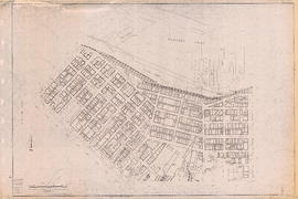
Rupert Street to Boundary Road
Part of City of Vancouver fonds

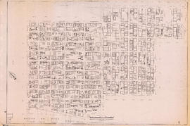
Welwyn Street to Rupert Street
Part of City of Vancouver fonds

Part of City of Vancouver fonds
![Sheet No. 56 [Ontario Street to SW Marine Drive to Ash Street to Fraser River]](/uploads/r/null/1/9/8/19805cc3ca1a36e79b75812124f4d19bc1cba5d9c9a5cbfda7eb2e5d00efe39d/792d979d-2b3f-44fb-8739-651d77bbef08-LEG1153_142.jpg)
Sheet No. 56 [Ontario Street to SW Marine Drive to Ash Street to Fraser River]
Part of City of Vancouver fonds
![Sheet No. 55 [Boundary Road to Sixty-sixth Avenue to ca. Tyne Street to Fraser River]](/uploads/r/null/3/a/c/3ac8590cc5a2246cce9796841569265201d54e629168c61ff788739a6da3a3d7/87ee0a66-62dc-4480-a8a7-583ba87ea320-LEG1153_142.jpg)
Sheet No. 55 [Boundary Road to Sixty-sixth Avenue to ca. Tyne Street to Fraser River]
Part of City of Vancouver fonds
![Sheet No. 54 [Boundary Road to Fifty-eighth Avenue to Tyne Street to Sixty-sixth Avenue]](/uploads/r/null/4/9/2/4925e281903d682f1a68e9722289d297d3b67f69de4977aca839c40d77ac6c47/d1cab1e4-ba00-4e71-a0b0-055f4b10f9bb-LEG1153_142.jpg)
Sheet No. 54 [Boundary Road to Fifty-eighth Avenue to Tyne Street to Sixty-sixth Avenue]
Part of City of Vancouver fonds
![Sheet No. 53 [Boundary Road to Forty-seventh Avenue to Tyne Street to Fifty-fifth Avenue]](/uploads/r/null/b/7/3/b738974ae4282e40f18c767c7add7909d5db6c15a03431d6482d0335fc8b7f1a/cac7c189-dcac-4f56-84f9-d36f083feb73-LEG1153_142.jpg)
Sheet No. 53 [Boundary Road to Forty-seventh Avenue to Tyne Street to Fifty-fifth Avenue]
Part of City of Vancouver fonds
![Sheet No. 52 [Boundary Road to Kingsway Avenue to Latta/Tyne Street to Forty-seventh Avenue]](/uploads/r/null/c/9/7/c9787c126bdd66e5fc93cd8e14abf9607c95b53c53ee51abfd56c5c1a3e1ff34/96e57a2c-bfc4-4471-8028-0f0277ff2039-LEG1153_142.jpg)
Sheet No. 52 [Boundary Road to Kingsway Avenue to Latta/Tyne Street to Forty-seventh Avenue]
Part of City of Vancouver fonds
![Sheet No. 51 [Boundary Road to Wellington Avenue to Joyce Street to Kingsway Avenue]](/uploads/r/null/0/8/9/089ba7d6dc97c2ea4343f6b95d25598d2dcbe135f9e1a39fceb3f0adc8b046fb/5a9b9f26-50d0-4a58-89c6-49c394b4947b-LEG1153_142.jpg)
Sheet No. 51 [Boundary Road to Wellington Avenue to Joyce Street to Kingsway Avenue]
Part of City of Vancouver fonds
![Sheet No. 50 [Boundary Road to Twenty-ninth Avenue to Rupert Street to Austrey/Vanness Avenue]](/uploads/r/null/5/2/9/52934c0a1ba6dd8c80559e3eeb8424dd638f7ee32fb05e5e51366bc0871c77b8/b9b3b18a-094e-4fab-bf6c-26680026d8e9-LEG1153_142.jpg)
Sheet No. 50 [Boundary Road to Twenty-ninth Avenue to Rupert Street to Austrey/Vanness Avenue]
Part of City of Vancouver fonds
![Sheet No. 49 [Tyne Street to Sixty-third Avenue to Carlton Street to Fraser River]](/uploads/r/null/7/b/7/7b781c0eb1728d147d6b43104b88ede85b451ab4dd87a8cd6e48bbc8c2620897/2b41070d-7d73-42b7-9111-a4e302573fe1-LEG1153_142.jpg)
Sheet No. 49 [Tyne Street to Sixty-third Avenue to Carlton Street to Fraser River]
Part of City of Vancouver fonds
![Sheet No. 48 [Tyne Street to Fifty-fifth Avenue to Carlton Street to Sixty-fourth Avenue]](/uploads/r/null/f/b/3/fb3b99f3c4012f98adfd3626254e61dc507170d72f08abc8122e4a4bca973e22/f9fb5f40-d7ae-4820-9beb-cf412855a2a1-LEG1153_142.jpg)
Sheet No. 48 [Tyne Street to Fifty-fifth Avenue to Carlton Street to Sixty-fourth Avenue]
Part of City of Vancouver fonds
![Sheet No. 47 [Tyne Street to Waverley Avenue to Carlton Street to Fifty-fifth Avenue]](/uploads/r/null/0/2/d/02d2ea6dd58f76cb1dea69e2e248d07d34d83ace41aaf53673576a79d3434798/dd8d0471-5263-4163-b660-ffa7aad783f9-LEG1153_142.jpg)
Sheet No. 47 [Tyne Street to Waverley Avenue to Carlton Street to Fifty-fifth Avenue]
Part of City of Vancouver fonds
![Sheet No. 46 [Latta Street to School Road to Carlton Street to Waverley Avenue]](/uploads/r/null/3/6/f/36f5f844e9ea290b57847087296d896d5a12daf000d786ac01e881e0499c5510/28507a18-a9f9-4492-bd9a-2ddfa8ede098-LEG1153_142.jpg)
Sheet No. 46 [Latta Street to School Road to Carlton Street to Waverley Avenue]
Part of City of Vancouver fonds
![Sheet No. 45 [Wessex/Joyce Street to Austrey/Euclid Avenue to Dundee Street to Forty-first Avenue]](/uploads/r/null/7/c/f/7cf9f762e9c215503c62d537372c957a9c5fe447703761c2c7a7c44cd0ed7540/8febd995-e66b-4dd3-a147-3ccad6cb2e8a-LEG1153_142.jpg)
Sheet No. 45 [Wessex/Joyce Street to Austrey/Euclid Avenue to Dundee Street to Forty-first Avenue]
Part of City of Vancouver fonds
![Sheet No. 44 [McHardy Street to Twenty-ninth Avenue to Moss Street to Horley Street]](/uploads/r/null/d/6/a/d6a3dc99a6b3f692c3fe9b210801b14df90ac6e9b951db09a961de7c7339c058/cb39b884-ce77-4369-b117-9c92e8ece5c6-LEG1153_142.jpg)
Sheet No. 44 [McHardy Street to Twenty-ninth Avenue to Moss Street to Horley Street]
Part of City of Vancouver fonds
![Sheet No. 43 [Moss Street to Twenty-ninth Avenue to Clarendon Street to Kingsway Avenue]](/uploads/r/null/2/f/e/2fed326a9408f52a6de451db8803f3ca1188e78d05a8232190e3902890c62b9c/fc9322a5-4780-49f8-8405-d209103ce7f0-LEG1153_142.jpg)
Sheet No. 43 [Moss Street to Twenty-ninth Avenue to Clarendon Street to Kingsway Avenue]
Part of City of Vancouver fonds
![Sheet No. 42 [Carlton Street to Sixty-fifth Avenue to Nanaimo Street to Fraser River]](/uploads/r/null/c/0/f/c0f25974b8cca0a9e6f1e4c1214f703f6abd3815da448a70c658b3c96348b904/cc4651ef-1513-4f8b-a413-bf5022a25c83-LEG1153_142.jpg)
Sheet No. 42 [Carlton Street to Sixty-fifth Avenue to Nanaimo Street to Fraser River]
Part of City of Vancouver fonds
![Sheet No. 41 [Carlton Street to Fifty-seventh Avenue to Nanaimo Street to Sixty-fifth Avenue]](/uploads/r/null/4/a/5/4a51356de1ddb79cb9aa5c6fc573bbbcf9640d4469550b5080b5981b049eace0/0ba2e77f-80d3-4101-84f9-df784bee297c-LEG1153_142.jpg)
Sheet No. 41 [Carlton Street to Fifty-seventh Avenue to Nanaimo Street to Sixty-fifth Avenue]
Part of City of Vancouver fonds
![Sheet No. 40 [Carlton Street to Forty-eighth Avenue to Nanaimo Street to Fifty-seventh Avenue]](/uploads/r/null/3/9/c/39c1f6a2674fda099f176d8500afe7bbadf4c2a8c241368656998837f098c9b6/7d092c70-6d84-4079-80f4-dd352813f3f1-LEG1153_142.jpg)
Sheet No. 40 [Carlton Street to Forty-eighth Avenue to Nanaimo Street to Fifty-seventh Avenue]
Part of City of Vancouver fonds