
The Big Hollow Tree, Stanley Park, Vancouver, Canada
- AM1052-: AM1052 P-2334
- Item
- [191-?]
The Big Hollow Tree, Stanley Park, Vancouver, Canada

Which road? Stanley Park, Vancouver, B.C.
Item is a postcard showing paths in Stanley Park. The back of the postcard includes personal correspondence addressed to Robert [Sense].

Siwash Rock, Vancouver, B.C. : looking towards English Bay, Vancouver, B.C.
Item is a postcard showing two images; one showing Siwash Rock, and the other showing the view looking towards English Bay. The back of the postcard includes personal correspondence addressed to Miss Lon [Hamm].

Malkin Memorial Bowl, Stanley Park, Vancouver, B.C., Canada
Item is a postcard printed with an image of the Malkin Memorial Bowl at Stanley Park. The back of the postcard includes personal correspondence addressed to Miss M. [Cleery].

Stanley Park showing forest monarchs, Vancouver, British Columbia
Item is a postcard printed with an image of trees in Stanley Park. The back of the postcard includes personal correspondence addressed to Dr. Emma J. Read.

Buffalo in Stanley Park, Vancouver, B.C.
Item is a postcard printed with an image of a buffalo in Stanley Park. The back of the postcard includes personal correspondence addressed to Miss Wanda Cullen.

The big tree , circumference 65 ft., Stanley Park, Vancouver, B.C., Canada

The big tree , circumference 65 ft., Stanley Park, Vancouver, B.C., Canada

Pacific Mills Ltd. picnic : Belcarra Park
![[Aerial view of Mount Pleasant, South Strathcona and Kensington-Cedar Cottage]](/uploads/r/null/7/5/75ea991fe8319eaffda79b314cbf20e281e35eb2cd8a89eaa898b492242d6282/05f856f3-0a45-41eb-94dc-46cb9d2f7ecf-A63348_142.jpg)
[Aerial view of Mount Pleasant, South Strathcona and Kensington-Cedar Cottage]
Part of Major Matthews collection
Photograph shows aerial view of the east end of False Creek, Thornton Park, Great Northern Railway and Canadian National Railway yards, Mount Pleasant, Strathcona, Grandview-Woodland, Trout Lake, Kingsway, Vancouver Technical School grounds, Renfrew playing fields, John Hendry Park, British Columbia Electric Railway Right of Way, Clark Park, Grandview Highway South, Great Northern Railway.
![[Aerial view of Vancouver]](/uploads/r/null/b/9/b973b9a4143a5316b02e728c35d99e383f27a3db21d8e20aa7bbb459780243bc/3ff38b56-6b36-4c17-bce1-329c97459d29-A66598_142.jpg)
Part of Major Matthews collection
Photograph shows Kitsilano, Kits Point, Kitsilano Beach, R.C.A.F. Equipment Depot, Kitsilano Pool, Burrard Bridge, C.P.R. Kitsilano Trestle, Granville Island, Granville Bridge, Cambie Bridge, False Creek, C.P.R. False Creek Yards, West End, Yaletown, Arbutus Ridge, Shaughnessy, South Cambie, Fairview, Mount Pleasant, Little Mountain Reservoir, Connaught Park, Quilchena Golf Course, Douglas Park, Shaughnessy Heights Golf Course, Queen Elizabeth Park, Royal Canadian Mounted Police Barracks, Shaughnessy Military Hospital, Hillcrest Park, Robertson & Hacket Sawmill, City Yard, West Coast Ship Builders and Athletic Park.
![[Aerial view of West Point Grey, Kitsilano, Dunbar - Southlands and University Endowment Lands]](/uploads/r/null/0/8/089d213e9a81ca689130a244122a86972e068c9b01ab994922a88072ac881121/1ed71859-c157-4686-82db-e3483cd4b877-A66599_142.jpg)
[Aerial view of West Point Grey, Kitsilano, Dunbar - Southlands and University Endowment Lands]
Part of Major Matthews collection
Photograph shows the south Slope of English Bay, Spanish Banks, Locarno Beach Park, Jericho Beach, R.C.A.F. Jericho Air Station, Kitsilano pool, Connaught Park and Kitsilano Beach Park, Caldecott Park, Quilchena Golf Course, School for Deaf and Blind and Quesnel Park.
![[Aerial view of Burrard Inlet, Hastings-Sunrise, Burnaby and the District of North Vancouver]](/uploads/r/null/d/f/df7e11c97173ce0473c454f0a01569b641972f6efdc12bf192edbc42119542d6/6d72f89b-9b55-48c4-bef6-04eb2137f1d3-A66600_142.jpg)
[Aerial view of Burrard Inlet, Hastings-Sunrise, Burnaby and the District of North Vancouver]
Part of Major Matthews collection
Photograph shows Exhibition Park and P.N.E. Golf Course, Second Narrows Bridge, New Brighton Park, Callister Park, Burrard Inlet, Lynn Creek, Lynn Park, Seymour Creek, Vancouver Harbour Commissioners Railway, Inspected Shingles Ltd., Cascade Rock and Gravel Co. Ltd., Canadian Shingle Co. Ltd. (Capilano Timber Co. Ltd.), Alberta Pool Elevator, Columbia Grain Elevator Co. Ltd., Canadian Pacific Railway, Girls Industrial School and Old Peoples Home sites.

Staff of Pure Milk Dairy Co. Samuel Garvin Prop. Vancouver B.C. 15/6/16
Part of Major Matthews collection
Photograph shows S. Garvin and others in an automobile among horse-drawn milk wagons and delivery men in front of a bandstand in Robson Park. The photograph also shows houses and buildings in the 500 block 13th Ave E. and the 2900 block Carolina Street.
![[Logging skid trail in Stanley Park]](/uploads/r/null/c/8/c85475e830cbbc0ebe0a968b70a19732b55884211ee1afd17251089afb598512/c3018567-504e-44ab-9e6c-57be58d7bd4f-A32019_142.jpg)
[Logging skid trail in Stanley Park]
Part of Major Matthews collection

Visit of Queen Elizabeth - dogwood - playground
Item is a documentary film documenting Queen Elizabeth's 1959 visit to Vancouver. The film shows preparation of a presentation for her visit to Queen Elizabeth Park as well as the presentation being viewed by Queen Elizabeth. The presentation consists of an assembly of children creating a dogwood-flower-shaped formation in the park.
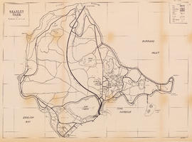
![Stanley Park [Golden Jubilee]](/uploads/r/null/2/4/24135e2d726e60ffbc74f0d81c3a53d51a38fe9ea1e86ecda92708249adac23b/1b46df5d-6871-41b2-b1dd-91a0c1d5ad02-MAP624_142.jpg)
Part of City of Vancouver Archives technical and cartographic drawing collection
Item is a copy of a map of Stanley Park which has been extensively annotated to depict plans for addressing traffic, parking and pedestrian regulations for events held in the park during the City's Golden Jubilee celebrations July-Sept. 1936.
Vancouver (B.C.). Board of Park Commissioners
Part of City of Vancouver Archives sound recording and moving image collection
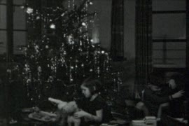
Item is a film containing home movie sequences including children playing with toys in front of a Christmas tree, family shots near a house, knitting, playing cards, backyard wading pool, and family in a park area.
Part of Ernie Reksten fonds
Shows Kits Point area

Group of men and women posing around a tree

Two women standing beside Brockton Point lighthouse and fog bell

Woman standing between road and Second Beach
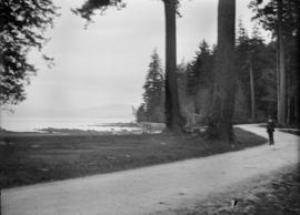
Man standing on pathway near beach in Stanley Park
![Ferguson Point Tea House [at Stanley Park]](/uploads/r/null/c/2/c2c6330864dca9869e9efa4d567e3a7bd0f62399f0554151079563dd58be4f56/5178db50-19f1-4141-b72a-5b06e1d8d20e-A59807_142.jpg)
Ferguson Point Tea House [at Stanley Park]
Part of City of Vancouver fonds

View of All Seasons Park in winter

View of All Seasons Park in summer

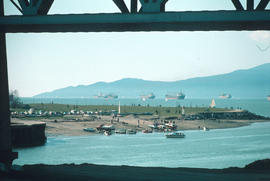
![[Apodaca Park (D.L. 4974) and Cove from the water]](/uploads/r/null/8/3/1/831e92f91dc63f1a13b6ac1d30818605131d79cd305173eae5b335537206cc75/a949b3da-0421-4e99-8ab9-dd0b5103947c-CVA371-215_142.jpg)
[Apodaca Park (D.L. 4974) and Cove from the water]
Part of Major Matthews collection
Item is a photograph made of 3 separate photographs joined together. Panoramic view. The sections have been described separately as CVA 371-215.1, CVA 371-215.2 and CVA 371-215.3.


This postcard includes personal correspondence addressed to Mr. A. E. Baggs of Worcester.

Clarence Park, Weston-Super-Mare
This postcard includes personal correspondence addressed to Miss Hilda Baggs of Bath.

Deer, Mt. Edgecumbe Park, Plymouth.

Part of Yaletown Productions Inc. fonds
Item is camera original raw footage for "Curse of the Lost Gold Mine." Includes an interview with John F. H. Thompson, a geologist at UBC, who talks about the geology of Pitt Lake, shots of a map of Pitt Lake and Michael Collier plotting out a route on the map, also includes an interview with Mike Boileau, who has been looking into finding gold in the Pitt Lake area since 1979, he talks about the curse, the stories of Pitt Lake, and his own experiences at Pitt Lake.

Development of railway properties at 1st Avenue and Main Street
Part of City of Vancouver fonds
Item is a map depicting proposed street and park developments along Main Street between 1st Avenue and Prior Street.
Vancouver (B.C.). Engineer's Office

People walking through a park - The Roy Wrigley Ltd. building in the background
Part of Stuart Thomson fonds

Taken for Frank Newton - Exteriors, houses in Grandview District - Park scene, Grandview Park
Part of Stuart Thomson fonds

Part of City of Vancouver Archives technical and cartographic drawing collection
Map is a City Engineering Department base map of Vancouver, showing city blocks and Canadian Pacific, Canadian National and Great Northern Railway lines. Parks, golf courses, hospitals, schools, theatres and other structures are identified. "Metric Vancouver" and "Guide Map 15" appear in the bottom right corner of the map.

A preliminary proposal for development of Jericho Park
Part of City of Vancouver Archives technical and cartographic drawing collection
Item shows proposed uses for Jericho Park.

City of Vancouver, British Columbia
Part of City of Vancouver Archives technical and cartographic drawing collection
Item is the western half of a map showing city blocks, transportation infrastructure, recreational facilities, hospitals, schools, theatres and other structures are identified. MAP 1036 is the eastern half of this map.
Vancouver (B.C.). Engineering Services

City of Vancouver, British Columbia
Part of City of Vancouver Archives technical and cartographic drawing collection
Item is the eastern half of a map showing city blocks, transportation infrastructure, recreational facilities, hospitals, schools, theatres and other structures are identified. MAP 1036b is the western half of this map.
Vancouver (B.C.). Engineering Services

Part of City of Vancouver Archives technical and cartographic drawing collection
Map is a City Engineering Department base map of Vancouver, showing city blocks and Canadian Pacific, Canadian National and Great Northern Railway lines. Parks, golf courses, hospitals, schools, theatres and other structures are identified. "Guide Map 15" appears in the bottom right corner of the map.
![City of Vancouver [park sites June/80]](/uploads/r/null/9/4/9484add7c4684ea3838e4d00ee8add3ecf85d78d5aa8fe2780cae273e59556a5/bd2464d8-2aa9-4501-aba6-8b3f7d130a42-MAP1032_142.jpg)
City of Vancouver [park sites June/80]
Part of City of Vancouver Archives technical and cartographic drawing collection
Map is a City Engineering Department base map of Vancouver, with parks hand-coloured in green. Shows city blocks and Canadian Pacific, Canadian National and Great Northern Railway lines. Golf courses, hospitals, schools, theatres and other structures are identified. "Metric Vancouver" and "Guide Map 15" appear in the bottom right corner of the map.

City of Vancouver, British Columbia : co-ordinate street index map 12
Part of City of Vancouver Archives technical and cartographic drawing collection
Map is City Engineering Department base map 149 of the City of Vancouver, showing city blocks, streets and railway lines, as well as the area code co-ordinates assigned by the department. Golf courses, hospitals, schools, theatres and other structures are also identified.

Commercial map of Greater Vancouver and district
Part of City of Vancouver Archives technical and cartographic drawing collection
Item is a map sheet containing two maps. The principal map depicts greater Vancouver, including portions of North and West Vancouver, Richmond and Surrey. The information depicted on the map includes streets, postal blocks, streetcar and railway lines, parks and golf courses, and schools. The map includes 1/2 mile distance circles centred on old City Hall at Main and Hastings.
The sheet includes an inset map of Granville Island. Depth of water given along shorelines of Burrard Inlet, English Bay, and along the West Vancouver coast from First Narrows to Howe Sound. The sheet includes an index of streets.
Part of City publications collection
Item is a map showing roads, trails, walkways, parking lots, buildings, shorelines, creeks, and swamps in Stanley Park.

Entrance to Stanley Park (causeway)

This postcard includes personal correspondence. Sent to Miss [Hilda] Baggs of Bath, England.

This postcard includes personal correspondence. Sent to [S. Alefhen?] Esq. of Vancouver, B.C. from A. J. Harrison.

This postcard includes personal correspondence. Sent to Mrs. J. Harrison of Penzance, England.

The lake, Jephson gardens, Leamington spa.
This postcard includes personal correspondence. Sent to Mrs. Baggs of Bath, England.