![Sheet 39A [Wallace Street to 10th Avenue to Discovery Street to 16th Avenue]](/uploads/r/null/d/e/6/de6660a119a0cdd1d10c1297f2cf1c2b4552e9ddec3edf92644013f9cc15e2e1/07059a40-a2f4-4334-9056-d62c618151ec-LEG1153_142.jpg)
Sheet 39A [Wallace Street to 10th Avenue to Discovery Street to 16th Avenue]
- PUB-: PD 2135-: LEG1153.278
- Part
- [ca. 1955] (copied ca. 1980)
Part of City publications collection
332 results with digital objects Show results with digital objects
Sheet 39A [Wallace Street to 10th Avenue to Discovery Street to 16th Avenue]
Part of City publications collection
![Sheet 39B [Blenheim Street to 10th Avenue to Wallace Street to 16th Avenue]](/uploads/r/null/b/8/e/b8e886c2e0544e1fcda547b926b902923ea6af25ef89e2aced11cf73832c5930/841000f9-3cf2-40b4-ace7-9c69ed16d64d-LEG1153_142.jpg)
Sheet 39B [Blenheim Street to 10th Avenue to Wallace Street to 16th Avenue]
Part of City publications collection
![Sheet 39C [Wallace Street to 16th Avenue to Discovery Street to King Edward Avenue]](/uploads/r/null/2/5/c/25c5aa22e403558f96fbd40e3ae0947be0ace24e232e953b87a2fb754b3fb1a3/ff315df3-3abc-48e3-b95c-305139a29e88-LEG1153_142.jpg)
Sheet 39C [Wallace Street to 16th Avenue to Discovery Street to King Edward Avenue]
Part of City publications collection
![Sheet 39D [Blenheim Street to 16th Avenue to Wallace Street to King Edward Avenue]](/uploads/r/null/0/6/5/0655bd0bc18c1c8d272023db21bec0565c5601b72c35586e5a716935161e4650/caafb621-700d-4541-8b4d-320e88161db9-LEG1153_142.jpg)
Sheet 39D [Blenheim Street to 16th Avenue to Wallace Street to King Edward Avenue]
Part of City publications collection
![Sheet 40A [Wallace Street to King Edward Avenue to Univsity Endowment Lands to 33rd Avenue]](/uploads/r/null/f/1/f/f1fd90433a6a288ac0a5c1cf28ccdf3020b21d50e9ccff5ce6c7f752a26ab030/c53b5933-6833-4457-8b54-75aa04b81180-LEG1153_142.jpg)
Sheet 40A [Wallace Street to King Edward Avenue to Univsity Endowment Lands to 33rd Avenue]
Part of City publications collection
![Sheet 40B [Blenheim Street to King Edward Avenue to Wallace Street to 33rd Avenue]](/uploads/r/null/a/d/0/ad02d0ef5c1b93f161c46247cc4614b2d56e9cd6a9ff6160d8287e89942f9956/9dd41d25-161b-4003-854d-d02e9a9898ff-LEG1153_142.jpg)
Sheet 40B [Blenheim Street to King Edward Avenue to Wallace Street to 33rd Avenue]
Part of City publications collection
![Sheet 40C [Wallace Street to 33rd Aenue to University Endowment Lands to 41st Avenue]](/uploads/r/null/8/5/6/856a4a832f68fa55c97dfecc6eed8ea78f09e3a96b2c14401b6340f61ae6fff8/85d634e1-5e30-45cf-a659-80c3efa9bf27-LEG1153_142.jpg)
Sheet 40C [Wallace Street to 33rd Aenue to University Endowment Lands to 41st Avenue]
Part of City publications collection
![Sheet 40D [Blenheim Street to 33rd Avenue to Wallace Street to 41st Avenue]](/uploads/r/null/3/7/3/3739bbdbc18fbe16d7162de0c6e02dde7965bc02d740ce4e4df465537ac85e04/89aa8116-832b-4979-9033-15d44b002b1f-LEG1153_142.jpg)
Sheet 40D [Blenheim Street to 33rd Avenue to Wallace Street to 41st Avenue]
Part of City publications collection
![Sheet 41A [Wallace Street to 41st Avenue to Musqueam Reserve to 49th Avenue]](/uploads/r/null/d/7/f/d7f1e8bd92ef76bcd7457d96a14646d040f9cc8a043fa474a88dbf056606dd90/cbe2dfc1-4957-4833-9e0f-6bb7f1d3c6a8-LEG1153_142.jpg)
Sheet 41A [Wallace Street to 41st Avenue to Musqueam Reserve to 49th Avenue]
Part of City publications collection
![Sheet 41B [Blenheim Street to 41st Avenue to Wallace Street to 49th Avenue]](/uploads/r/null/7/b/2/7b2dd608c9e447bf448dcfc09ed76f8691e4c1e216e012b1b2e2776c5196a218/ad8b9cc6-c5a4-4aa4-8286-2fb92afe4f82-LEG1153_142.jpg)
Sheet 41B [Blenheim Street to 41st Avenue to Wallace Street to 49th Avenue]
Part of City publications collection
![Sheet 41D [Blenheim Street to 49th Avenue to Musqueam Reserve to Fraser River]](/uploads/r/null/e/9/2/e92fc5827e22fcead9e0370739bc0dfbf09b3591c72f423289effff3fdd52ebe/55542ee4-2c2b-4357-ad50-9c533e59a857-LEG1153_142.jpg)
Sheet 41D [Blenheim Street to 49th Avenue to Musqueam Reserve to Fraser River]
Part of City publications collection
![Sheet 42B [Blenheim Street to Celtic Avenue to Fraser River]](/uploads/r/null/d/0/f/d0f904ceb3f9e449b3756ccfde3fdf618ac91b559883559e2cc0e567d57d7a15/c8590d75-7fb0-42c1-b582-67f9b91bfed6-LEG1153_142.jpg)
Sheet 42B [Blenheim Street to Celtic Avenue to Fraser River]
Part of City publications collection
![Sheet 43A [Blanca Street to English Bay to University Endowment Lands to 2nd Avenue]](/uploads/r/null/1/c/b/1cb8433ea45730d34fcc1fe1f92271f79a3eaa3903473a761e4f878170fa5191/ff8939af-97c6-4154-acc1-0d8a868fc66f-LEG1153_142.jpg)
Sheet 43A [Blanca Street to English Bay to University Endowment Lands to 2nd Avenue]
Part of City publications collection
![Sheet 43B [Discovery Street to English Bay to Blanca Street to 2nd Avenue]](/uploads/r/null/2/1/0/21007a691605ce3411c27c74a7e68e1ecc145d09c86feadc96ecb9b090f3c96e/bff71469-8c56-4157-b106-946d78ab28bd-LEG1153_142.jpg)
Sheet 43B [Discovery Street to English Bay to Blanca Street to 2nd Avenue]
Part of City publications collection
![Sheet 43C [Blanca Street to 2nd Avenue to University Endowment Lands to 10th Avenue]](/uploads/r/null/8/e/a/8ea10dc3c6492327a5e0addd9018cab3617de431e837beda4233bb94d8c2db98/d339ad6e-552a-4c6c-a353-a547405cbf57-LEG1153_142.jpg)
Sheet 43C [Blanca Street to 2nd Avenue to University Endowment Lands to 10th Avenue]
Part of City publications collection
![Sheet 44B [Discovery Street to 10th Avenue to Blanca Street to 16th Avenue]](/uploads/r/null/0/f/7/0f7db59d1a90e970d1a27d525155c52735957e90e75e1142b86be956483805d9/ff72da6d-d789-4ce6-9b3d-9361505882c7-LEG1153_142.jpg)
Sheet 44B [Discovery Street to 10th Avenue to Blanca Street to 16th Avenue]
Part of City publications collection
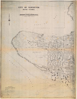
City of Vancouver, British Columbia : Point Grey to Cypress Street
Part of City publications collection
Part is the west half of a map of Vancouver showing streets, address block numbers, parks, schools, golf courses, First Nations reserves, railways, and topographic contour lines.

City of Vancouver, British Columbia : Cypress Street to Boundary Road
Part of City publications collection
Part is the east half of a map of Vancouver showing streets, address block numbers, parks, schools, golf courses, First Nations reserves, railways, and topographic contour lines.

City of Vancouver, B.C. area map : Maple Street to Heatley Avenue and Burrard Inlet to 6th Avenue
Part of City publications collection

Part of City publications collection

Part of City publications collection

City of Vancouver, B.C. area map : Inverness Street to Boundary Road and 32nd Avenue to 54th Avenue
Part of City publications collection

Part of City publications collection

Part of City publications collection

Part of City publications collection

Part of City publications collection

Part of City publications collection

Part of City publications collection

Part of City publications collection


Part of City publications collection

Vancouver Parks and Recreation : a guide to services
Part of City publications collection

Part of City publications collection

Vancouver Parks and Recreation : a guide to services
Part of City publications collection
Part of City publications collection
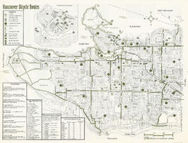
Part contains a map of Vancouver bicycle routes with a key to attractions, bridges and ferries, and downtown bicycle parking locations. An inset map shows Downtown Vancouver in more detail.

Part of City publications collection
Part contains safety and security information for cyclists and a small map of major bikeways in Vancouver.

Part of City publications collection
Part contains a map of Vancouver bicycle routes with a key to attractions, bridges and ferries, and downtown bicycle parking locations. An inset map shows Downtown Vancouver in more detail.

Part of City publications collection
Part contains safety and security information for cyclists and a small map of major bikeways in Vancouver.
Vancouver Parks and Recreation : map and guide
Part of City publications collection
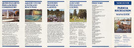
Part contains information about Vancouver attractions including Queen Elizabeth Park, the Vancouver Aquatic Centre, VanDusen Botanical Gardens, and golf courses.

Vancouver Parks and Recreation : map and guide
Part of City publications collection
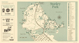
Part contains a map of Vancouver showing major roadways and locations of attractions advertised in the pamphlet, a map of Stanley Park in more detail, and textual information on Stanley Park and Vancouver beaches.

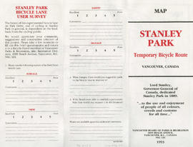
Stanley Park : map showing temporary bicycle route
Part of City publications collection
Stanley Park bicycle lane user survey
Part of City publications collection

Stanley Park map and guide : park history, food services, and general information
Part of City publications collection

Stanley Park map and guide : park map showing trails, amenities, and recreation sites
Part of City publications collection

Stanley Park map and guide : park history, food services, and general information
Part of City publications collection
Stanley Park map and guide : park map showing trails, amenities, and recreation sites
Part of City publications collection

One way streets : illustrations of special intersections
Part of City publications collection
Part contains pamphlet cover and illustrations showing traffic flow at the intersections of Robson Street and Cambie Street, Richards Street, Water Street, and Cordova Street, and Beatty Street and Pender Street

One way streets : Illustrated map of Downtown Vancouver
Part of City publications collection
Part contains an illustrated map of Downtown Vancouver showing traffic flow along new one-way streets. Illustration has been annotated with address block numbers and continuations of streets directly east of Main Street.

Part of City publications collection
Part contains a map of the north half of Vancouver (Burrard Inlet to 22nd Avenue) showing bicycle routes, parks, and SkyTrain stations, and textual information on downtown bicycle parking and combining cycling with public transit.

Part of City publications collection
Part contains a map of the south half of Vancouver (22nd Avenue to the Fraser River) showing bicycle routes, parks, and SkyTrain stations, a list of useful contacts for cyclists, and information on bridges and connections.