Print preview Close

Showing 1835 results

Archival description
City of Vancouver Archives technical and cartographic drawing collection
Print preview View:

1440 results with digital objects Show results with digital objects

Vest pocket map of Vancouver : map D
Vest pocket map of Vancouver : map cover
Vest pocket map of Vancouver : map B
Postal Station [Granville and West Hastings streets]
Index plan of provincial government lands to be sold at auction at Vancouver B.C. November 20, 1906
Plan of provincial government property being a portion of townsite of Vancouver and sub-division ...
Plan of provincial government property being a portion of townsite of Vancouver and sub-division of lot 540, group 1, New Westminster District, B.C., to be sold by public auction at Vancouver, B.C.
Plan of Vancouver Harbour and False Creek, Vancouver, B.C., showing proposed improvements as outl...
Plan of Vancouver Harbour and False Creek, Vancouver, B.C., showing proposed improvements as outlined in Jos. R. Roy's reports dated 15th Sept. 1906
Plan of False Creek, Vancouver, B.C.
Plan of part of sub-division of district lot 540, South Vancouver, provincial government property
Map of portion of New Westminster District with adjacent islands and part of Vancouver Island
Plan of provincial government property being a sub-division of a portion of expired timber lease ...
Plan of provincial government property being a sub-division of a portion of expired timber lease situated in North Vancouver, New Westminster district, B.C., to be sold by public auction
Plan of sub-division of lot 2027, group 1, New Westminster District, B.C., to be sold by public a...
Plan of sub-division of lot 2027, group 1, New Westminster District, B.C., to be sold by public auction at Vancouver, B.C.
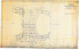
CPR Vancouver Opera House balcony plan
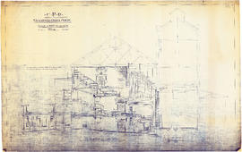
CPR Vancouver Opera House transverse section and basement plan
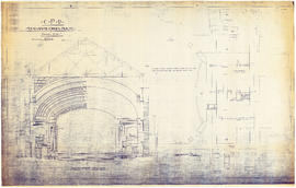
CPR Vancouver Opera House longitudinal section
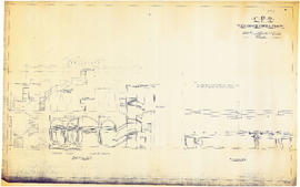
CPR Vancouver Opera House sections A-A and B-B
CPR Vancouver Opera House trusses for gallery and balcony
CPR Vancouver Opera House elevation to Farrell apartment building [south]
CPR Vancouver Opera House elevation to hotel [north]
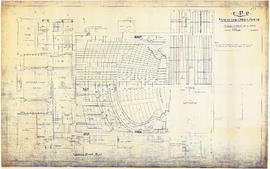
CPR Vancouver Opera House ground floor plan
CPR Vancouver Opera House Gallery plan, ceiling plan and section
Plan of the City of Vancouver, British Columbia
East Vancouver Heights
Plan of the City of Vancouver
Drawings of first Vancouver opera house (761 Granville Street)
Plan of the City of Vancouver
East Vancouver Heights
Bird's eye view of Vancouver, B.C.
Map of the south-western part of British Columbia
Vancouver and Northern Railway, 1908
Geological map of parts of Nanaimo and New Westminster mining divisions
City of Vancouver, B.C., Canada, 1908
First Narrows. Proposed Suspension Bridge for Foot Passengers Only
Plan of subdivision of part of D.L. 526, New Westminster District, B.C., Kitsilano, City of Vanco...
Plan of subdivision of part of D.L. 526, New Westminster District, B.C., Kitsilano, City of Vancouver
First Narrows, Burrard Inlet, B.C. showing Parthia and Burnaby shoals
Revised list of remaining 50 lots in subdivision of south half of section 35, Hastings Townsite
Vancouver, B.C. Plan showing location of water pipes, hydrants, etc. [Fairview slopes]
Vancouver, B.C. Plan showing location of water pipes, hydrants, etc. [Westminster Avenue to McLea...
Vancouver, B.C. Plan showing location of water pipes, hydrants, etc. [Westminster Avenue to McLean Drive]
Hastings Townsite [Boundary Road to 5th Avenue to Kamloops Street (?) to 33rd Avenue]
Views of Vancouver
Views of Vancouver
Map and views of the terminal city, Vancouver, British Columbia, Canada : map cover
Vancouver, B.C. Plan showing location of water pipes, hydrants, etc. [West End]
Map and views of the terminal city, Vancouver, British Columbia, Canada
Map of Grandview and east end
Warehouse and store sites : very centrally located
Hastings Townsite [Boundary Road to English Bay to Commercial Drive to Charles Street]
Vancouver, B.C. Plan showing location of water pipes, hydrants, etc. [Victoria Drive to First Ave...
Vancouver, B.C. Plan showing location of water pipes, hydrants, etc. [Victoria Drive to First Avenue to Prince Edward Street to 16th Avenue]
Vancouver, B.C. Plan showing location of water pipes, hydrants, etc. [Burrard Street to Gore Avenue]
Map and views of the terminal city, Vancouver, British Columbia, Canada : inside map cover
Results 251 to 300 of 1835