![Lillian [Wong] recently [41 of 79]](/uploads/r/null/d/5/4/d54c9fce31b5c6823b1edccbbc40041624255dd24d8136d0a4994f0aecb07d45/f93e548d-8380-464e-a520-fa074287668c-2008-010_142.jpg)
Lillian [Wong] recently [41 of 79]
- AM1523-S5-1-F064-: 2008-010.3352
- Item
- [197-]
Part of Paul Yee fonds
462 results with digital objects Show results with digital objects
Lillian [Wong] recently [41 of 79]
Part of Paul Yee fonds

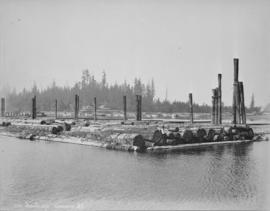
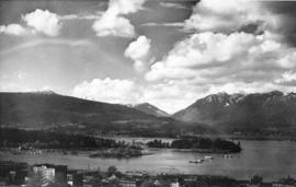
Lipsett boats - "Harris No.3", "Hollyburn"

This postcard includes personal correspondence addressed to Maurice Baggs of Vancouver.
![[Looking east from the Stanley Park bridge to Coal Harbour]](/uploads/r/null/c/5/c5d5a12a1c9782ab5a8523900877fe279312841636d16b6c49d45f78c661b618/886c6082-bc19-41a2-a743-6880e2727074-A43209_142.jpg)
[Looking east from the Stanley Park bridge to Coal Harbour]
Part of Major Matthews collection
Photograph shows the B.C. Broom and Brush Works building
Looking N across harbour, Vancouver, B.C.
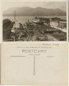
Item is a postcard printed with an image of the North Vancouver ferry dock in Vancouver Harbour. Passengers on foot and in cars are pictured disembarking from a ferry. The Grand Trunk Pacific Railway dock is also shown; a steamship is moored on its west side. North Vancouver is visible in the distance.

Looking over Brockton Point, Stanley Park
Part of Major Matthews collection
Photograph shows Coal Harbour and Stanley Park from the West End.
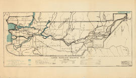
Lower Mainland Regional Plan : harbour areas
Part of Community Planning Association of Canada, British Columbia Division fonds

Map of the harbour of New Westminster, British Columbia
Part of City of Vancouver Archives technical and cartographic drawing collection
Item is a map showing the Fraser River and its North Arm as well as the Westminster Waterway surrounding New Westminster. A key map shows the location of New Westminster in relation to the Greater Vancouver area.
Item includes an article about Northland Navigation Company Limited.

Item is aerial view from downtown Vancouver showing Coal Harbour, Deadman's Island and the North Shore Mountains.
![Mr. G.B. Warren, Pacific Motor Boat, loading yachts on scow [False Creek]](/uploads/r/null/f/2/f232cac9c03fef859e1f5924b275b39d362d773c6832127117a54cac2812e910/5efc456e-cf3b-46c8-a964-4e3d5bb91ce3-A01562_142.jpg)
Mr. G.B. Warren, Pacific Motor Boat, loading yachts on scow [False Creek]
Part of Stuart Thomson fonds
![Mr. G.B. Warren, Pacific Motor Boat, loading yachts on scow [False Creek]](/uploads/r/null/3/d/3de4a6c7f897b524e96125c76b31a4f9cc8f0fdb760b732c70e777151e599f8e/538827c0-3fdd-4563-8064-633ec45e13e4-A01561_142.jpg)
Mr. G.B. Warren, Pacific Motor Boat, loading yachts on scow [False Creek]
Part of Stuart Thomson fonds
Imperial Gasoline signboard in background.
![Mr. G.B. Warren, Pacific Motor Boat, loading yachts on scow [False Creek South]](/uploads/r/null/3/d/3d64427c867440e7d963d876580d7a96d4e51be7df567c1fc70173c55e3642d4/bca9a4db-6ce1-43f2-a5a9-4093881390a7-A01560_142.jpg)
Mr. G.B. Warren, Pacific Motor Boat, loading yachts on scow [False Creek South]
Part of Stuart Thomson fonds
National Harbours Board Annual report 1975
National Harbours Board News Bulletin
![[Native Indian canoe races in Inner Harbour, Victoria]](/uploads/r/null/0/b/0bda6af6044a499cb77794faa4697c0d3b543bfdb67d3fcfbefc6fb24c0058d4/e732393e-bed4-45e2-955a-ad84e9fa5cd0-A04498_142.jpg)
[Native Indian canoe races in Inner Harbour, Victoria]
Part of Major Matthews collection
J.S. Matthews' notes with print or negative in Archives.
![Night anchorage [ship in harbour at night]](/uploads/r/null/a/c/7/ac7becd2001978d369e1369a06041cedb04449b387fc7615e117d5f85b1ad96f/aaf4055b-b828-47aa-8665-042681035b65-CVA293-105_142.jpg)
Night anchorage [ship in harbour at night]
![Night anchorage [ship in harbour at night]](/uploads/r/null/0/6/6/06647be38f6807165c759737e53d28f14dd6191776eeab4143c2539975e9a5fd/06d22039-ab94-425f-9b91-95dc179236d1-CVA293-105_142.jpg)
Night anchorage [ship in harbour at night]

No. 1053, Burrard Inlet, Vancouver, B.C.
Item is a postcard showing the Burrard Inlet. The back of the postcard includes personal correspondence.
![No wheat [view from Kitsilano Beach of freighter anchored in the harbour]](/uploads/r/null/a/f/7/af7f69cd835c3dcc952e2f300902fff6acddff87492c075566311f576b51c92b/8c5a57f2-5cdd-45ed-afd7-78b655941080-CVA293-135_142.jpg)
No wheat [view from Kitsilano Beach of freighter anchored in the harbour]
![No wheat [view from Kitsilano Beach of freighter anchored in the harbour]](/uploads/r/null/2/3/6/23667b976ce7a35f7a67eb8c0fbe7bf5f94840e88af4840d63ba4336aedc66f9/40c88020-4643-490e-afbc-b432b9612f3b-CVA293-135_142.jpg)
No wheat [view from Kitsilano Beach of freighter anchored in the harbour]
![[North facing cityscape view of the West End showing the] Sheraton-Landmark](/uploads/r/null/7/d/7db38a96995179fe1118994e0c35380cbd8d1bc5909f43a9cb352ba83ea17b88/9e677767-fb6d-4420-91d8-8152f5d4ede1-A59252_142.jpg)
[North facing cityscape view of the West End showing the] Sheraton-Landmark
Part of City of Vancouver fonds
Photograph also shows Coal Harbour and the North Shore
Part of Major Matthews collection
Photograph also shows Coal Harbour, the second Hotel Vancouver under construction.

Part of Major Matthews collection
Photograph also shows Coal Harbour, the second Hotel Vancouver under construction and Holy Rosary cathedral and St. Andrew's Presbyterian Church.
North Vancouver-Vancouver ferry schedule : January 13, April 28, April 29, 1969
![[Northeast view of downtown Vancouver from the roof of the Hotel Vancouver]](/uploads/r/null/d/e/de95d099d1517793665187336820ebdb65db9f066b651b935a78788383053fb3/5b49058f-4381-43c8-b28f-9755248fa953-A63006_142.jpg)
[Northeast view of downtown Vancouver from the roof of the Hotel Vancouver]
Part of Major Matthews collection
Panoramic view showing Coal Harbour, Deadman's Island, Burrard Inlet, the S.S. "Charmer", the Winch Building under construction, the Bank of Montreal and the Hudson's Bay Co. buildings.
![[Northern view of downtown Vancouver from the World Building at 500 Beatty Street]](/uploads/r/null/c/5/c5a97982fe48806e527a2356c3596800ee386904520184558d1eb65128635907/f3ea7ce2-2a4c-40da-a5a9-2ccfa6c170b1-A63886_142.jpg)
[Northern view of downtown Vancouver from the World Building at 500 Beatty Street]
Part of Major Matthews collection
Photographs shows Central Public and Vancouver High Schools, the Dominion Bank and Vancouver Daily Province Buildings, Coal Harbour, C.P.R. Pier D and Deadman's Island and the North Shore in the background
![[Northern view of downtown Vancouver from the World Building at 500 Beatty Street]](/uploads/r/null/9/5/95cc16c6b26e463eb28bc5ac8abec9ec6723150a2aefbca7850f264a2adff766/e88985ba-abeb-4d06-8eea-2bf10a834381-A63885_142.jpg)
[Northern view of downtown Vancouver from the World Building at 500 Beatty Street]
Part of Major Matthews collection
Photographs shows Central Public and Vancouver High Schools, the Dominion Bank and Vancouver Daily Province Buildings, Coal Harbour, C.P.R. Pier D and Deadman's Island and the North Shore in the background.
![[Northern view of downtown Vancouver from World Building, 500 Beatty Street]](/uploads/r/null/9/9/997cc0ffa3d5b19d17a58c9f16a1c6f9855c9019e5f3249c78d456803ea58779/b52f219d-f015-40b1-96a6-c089ab3c8d70-A63175_142.jpg)
[Northern view of downtown Vancouver from World Building, 500 Beatty Street]
Part of Major Matthews collection
Photograph also shows Central Public School, Victory Square, Vancouver Daily Province and Dominion Bank Buildings, the Flack Block and C.P.R. Piers B and C and the North Shore in the background.
![[Northward view of Downtown Vancouver from the tower of the Vancouver Block]](/uploads/r/null/7/e/7e88d0ca5a3c8b27417b0772731b3b9c8e8116caba7efef77325c3bfdf9ef14d/7ff76790-0eb3-4328-b584-8e7978589537-A63884_142.jpg)
[Northward view of Downtown Vancouver from the tower of the Vancouver Block]
Part of Major Matthews collection
Photograph also shows the upper floors and the roof garden of the second Hotel Vancouver, Burrard Inlet and the North Shore in the background.
![[Northwest facing cityscape view of the West End]](/uploads/r/null/8/1/8144b464121d2d606915a295fe4bfea95b903893f4ac909e59d22d27b3a6c7db/c58f4286-e96d-4189-ad75-9885f1b17ff7-A59249_142.jpg)
[Northwest facing cityscape view of the West End]
Part of City of Vancouver fonds
Photograph also shows buildings in the West End, English Bay, Stanley Park, Coal Harbour, Burrard Inlet, and the North Shore
![[Northwest view of Vancouver from Dunsmuir and Hornby Streets]](/uploads/r/null/8/8/88e94ad7604ed40fb7780d502fd141151ebddd9bddf50fa36b4b55a7abda9b58/e8c12a8c-3224-4083-b222-e4b83a4a6952-A65789_142.jpg)
[Northwest view of Vancouver from Dunsmuir and Hornby Streets]
Part of Major Matthews collection
Panoramic view shows Deadman's Island, Brockton Point, Vancouver Rowing Club, Immigration building, C.P.R. Pier A, Y.W.C.A. Building, B.P.O.E. Clubrooms and the Metropolitan building.
![N.P.A.A.O. [North Pacific Association of Amateur Oarsmen. Four-man sculls at] Esquimalt](/uploads/r/null/3/9/9/39987f37873391a1c3f2c8d1a3117b3b780fd35f99916cea9c357f5094bb1227/15ea02ff-5b9a-4e86-9d07-ac6d7e360763-CVA7-317_142.jpg)
N.P.A.A.O. [North Pacific Association of Amateur Oarsmen. Four-man sculls at] Esquimalt
Part of James Luke Quiney fonds
![N.P.A.A.O. [North Pacific Association of Amateur Oarsmen. One-man scull at] Esquimalt](/uploads/r/null/2/c/7/2c7a041f4573b48dfe710ad66ac640d7e95a4566083535aa2ed127c5268a1b18/931a73ba-3eb4-4564-9a85-04a72e883331-CVA7-318_142.jpg)
N.P.A.A.O. [North Pacific Association of Amateur Oarsmen. One-man scull at] Esquimalt
Part of James Luke Quiney fonds


![Ocean Falls [harbour dredging]](/uploads/r/null/1/e/1e7e09e17dcb3d0b28a30119bceaa2f16244f3ff09e4db0d582bf8f4d720d60c/64cfdccc-461e-4627-b615-908f9ba91921-A31758_142.jpg)
Ocean Falls [harbour dredging]
Part of Major Matthews collection
![Outward bound [Ferncliff leaving the harbour]](/uploads/r/null/0/d/4/0d48abd626ba40c2b0d1fe79807eaa4cf505575e2ddce6ff434ab2a594cfffa7/e4e279ea-7b71-4405-a67c-ed0859a6a8b8-CVA293-128_142.jpg)
Outward bound [Ferncliff leaving the harbour]
![Outward bound [Ferncliff leaving the harbour]](/uploads/r/null/9/4/1/941ada3c187bf82c8b708a7f34b8b35801419807e0815d2ad523a12b9e6570be/b8290159-6586-40fc-a089-d7bdd4808d85-CVA293-128_142.jpg)
Outward bound [Ferncliff leaving the harbour]
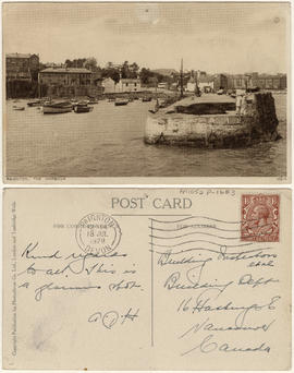
This postcard includes personal correspondence addressed to Building Inspectors, Building Dept. of Vancouver.
![[Parliament Buildings, Victoria, B.C.]](/uploads/r/null/d/0/d0f3827fcba74f71918e13419e6a10f2abbb53aad9ccd3b6e764a59a8e42e0d6/58091dda-eca1-43d9-83d4-2ad2d2a77bb5-A04350_142.jpg)
[Parliament Buildings, Victoria, B.C.]
Part of Major Matthews collection
J.S. Matthews' notes with print or negative in Archives.
![Pender Harbour showing [S.S.] "Comox"](/uploads/r/null/a/8/a830ad06450de793e74a3abcd7300572c52301769d6143086b9a050810f238d5/0c246306-10a0-4982-853f-19c126520072-A76290_142.jpg)
Pender Harbour showing [S.S.] "Comox"
Part of James Crookall fonds
Part of Major Matthews collection
Plan of False Creek, Vancouver, B.C.
Part of City of Vancouver Archives technical and cartographic drawing collection
Map shows streets, railways, land to be reclaimed, foreshore applied for, foreshore granted by order in council, proposed wharf lines, areas to be dredged and land ownership in and along False Creek. A key map in the top right-hand corner shows the location of False Creek in relation to the rest of Vancouver.

Plan of the City of Vancouver, B.C.
Part of City of Vancouver Archives technical and cartographic drawing collection
Item is a map of the old City of Vancouver south to 16th Avenue. The map depicts District Lots and blocks, railway lines, street car lines, industrial areas, parks, postal information, schools, property boundaries.

Part of City of Vancouver Archives technical and cartographic drawing collection
Item is a map showing major landmarks, railway lines, harbour lands reclaimed, proposed wharves and piers, retaining walls and dredging, and soundings in fathoms in Vancouver Harbour (Burrard Inlet) and False Creek.