![[Canoe on] Lake Louise](/uploads/r/null/9/f/9fe7dfe1017f9a6397c74d5508a13b6392d71e9a3082eaeb3b70a95be3b870ee/5c523e42-60df-4bfc-b62d-d5c13ed4003a-A07033_142.jpg)
- AM1545-S3-: CVA 586-332
- Item
- 1940
316 results with digital objects Show results with digital objects
![[View of] Lake Louise [and Rocky Mountains]](/uploads/r/null/7/b/7bfe3b977e314711cad2ccfc68eaaacb11dd78dfb73b09d3b26aab7d9732ecf5/bb6850cd-1e7c-4d95-a16e-d626ddd7b16e-A07034_142.jpg)
[View of] Lake Louise [and Rocky Mountains]


![View of Lake Louise [and the Rocky Mountains]](/uploads/r/null/e/a/ea6751400a037235d94d20c80f6e24a9e11a45acd3a519334766c12651f71272/99da980a-2b71-40b8-bf7f-7b72a6206a3c-A07037_142.jpg)
View of Lake Louise [and the Rocky Mountains]


Head and shoulders studio portrait

Full-length studio portrait

photograph shows view of Mountainholm Lodge

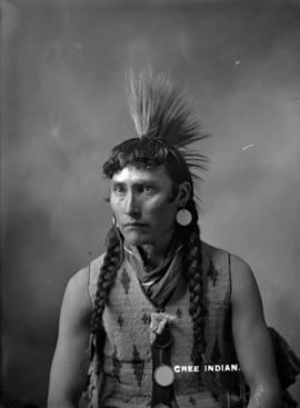
Running Rabbit - Chief Blackfeet Indians
Full-length studio portrait
Head and shoulders studio portrait
![Duke and Duchess of Windsor watching [a cattle drive] at Bar U Ranch](/uploads/r/null/3/b/3b140bf006bb5acfccaef86da6199bd69ea45aa41a033249d1c078461efe6d6c/80be9c1f-8989-4b76-8d66-2b592ea911db-A07334_142.jpg)
Duke and Duchess of Windsor watching [a cattle drive] at Bar U Ranch

Duke and Duchess of Windsor watching calf-branding at Bar U Ranch

Full-length studio portrait

Full-length studio portrait
![The Great Divide [and the Sir James Hector monument in] Banff National Park](/uploads/r/null/2/a/2a4730bbff21b2b6eb0cbacde340d587d6225a2a9d32d3d8fb7f175612233b78/e990820b-f527-47f4-ad5b-c2801e14f939-A25540_142.jpg)
The Great Divide [and the Sir James Hector monument in] Banff National Park
Part of Major Matthews collection

Pacific Express descending western slopes of Rockies along Kicking Horse River, C.P.R.
Part of Major Matthews collection

Survey party, Castle Mountain, Albt., Rocky Mts.
Part of Major Matthews collection
Photograph shows a group of men assembled in front of tents in valley.
![[Various sites in the Rocky mountains]](/uploads/r/null/2/7/27fc60badd08d42091596cb56f0d74aa6fc6269f2a08409224263c5e0ba34121/e25f932c-c2b9-4f26-9a51-74fdbd5fa0c0-A08097_142.jpg)
[Various sites in the Rocky mountains]
Part of Major Matthews collection
Photograph negative is a copy of several photograph prints, showing scenes such as Devil's Creek, view of Banff, lakes, bridges, and other sites

Part of Major Matthews collection
Photograph negative is a copy of four photograph prints: View of Bow River from Banff Hotel; Bridge over Bow River; Lake Louise and Fraser Canyon with Cisco Bridge in the distance
![[Three Sisters mountain peaks near Banff]](/uploads/r/null/c/c/cca0f3b29b5af041cda0516c35d3bddb0178848f68d4c96d3f1613b1f7891747/2e6e7afb-1f83-4029-b6ab-ea2eda600e7d-A08099_142.jpg)
[Three Sisters mountain peaks near Banff]
Part of Major Matthews collection
![[View of Mt. Temple], looking across C.P.R. track and Bow River](/uploads/r/null/0/d/0d2e4aae98c6a62b4d06754f3d30ea829acd28f74a81fb84dfd63f0929d6a5f4/749dbdba-cc20-4aa5-a95c-a840cb88261e-A08103_142.jpg)
[View of Mt. Temple], looking across C.P.R. track and Bow River
Part of Major Matthews collection
Photograph shows three men on railway track in foreground, with Mt. Babel (distant peak on the left).

Map of Manitoba, Keewatin, British Columbia, and North West Territory
Part of City of Vancouver Archives technical and cartographic drawing collection
Item is a map showing the route of the Canadian Pacific Railway through western Canada.

Part of City of Vancouver Archives technical and cartographic drawing collection
Item is a map showing the extent of the Canadian Pacific Railway Company (C.P.R.) in Canada in 1883. Map shows boundaries, roads, trails, telegraph lines, towns, rivers, lakes and mountainous terrain in British Columbia, the North West Territory (Alberta, Athabasca, Saskatchewan, Assiniboia), Manitoba and Kewaydin, as well as some of Ontario and Western Quebec. Map is folded inside a book titled "North West Territory, Canada."
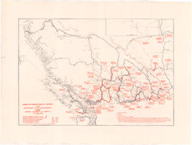
Part of City of Vancouver Archives technical and cartographic drawing collection
Item is a map showing the locations of and details associated with unemployment relief works projects in British Columbia and western Alberta. An inset map shows the Peace River highways. The location of projects, project number, and information of staffing numbers, accommodation and in some cases man-days of the project are noted.
![[View of the glacier on the mountains and the Valley of the Ten Peaks in the Rocky Mountains]](/uploads/r/null/6/7/675f29d340046e66f23f170287dde469408ff6e875b630567c7e48be3df62512/95ca71cd-ba5c-4923-bb19-d7cab9563661-A32813_142.jpg)
[View of the glacier on the mountains and the Valley of the Ten Peaks in the Rocky Mountains]
Part of Major Matthews collection
![[Descending the glacier into the Valley of the Ten Peaks]](/uploads/r/null/8/2/8200a78ca6265e81872aa816746f15f98f65f0ed5625ba56fd0c80d435d24538/7302efea-d632-4aec-9f74-b902232f59b0-A32815_142.jpg)
[Descending the glacier into the Valley of the Ten Peaks]
Part of Major Matthews collection

Part of Major Matthews collection

Part of Major Matthews collection

Part of Major Matthews collection
![[Crossing glacier to reach Mount Huber]](/uploads/r/null/5/e/5eb2cb2f14e160a6993cb5c54df6e8157aad6fed32e9f0ba1a9e6ec55ade4838/65d110cc-1c5a-4eea-88af-f1cdcd3bfe92-A32841_142.jpg)
[Crossing glacier to reach Mount Huber]
Part of Major Matthews collection

Part of Major Matthews collection
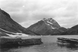
![[Mount Assinaboine]](/uploads/r/null/1/9/197328446d31c1b95cbf60d94e611a4d98d2efb947af81dfdf29388020d92bce/ffb7e154-01c5-40b1-b49b-275ee7c4404b-A32843_142.jpg)
Part of Major Matthews collection
Lake McArthur and Mount Oderay
Part of Major Matthews collection
![[View of Mount Biddle, Biddle Glacier and part of Lake McArthur]](/uploads/r/null/5/4/548bdf86e7e3de5b3209d41c7cedbd4e9eb97e6bcbc72ea98ac0575668224797/b9a3fa6f-a63d-45e3-b567-2c958d3657e6-A32845_142.jpg)
[View of Mount Biddle, Biddle Glacier and part of Lake McArthur]
Part of Major Matthews collection
![[Twin Falls from Mount McArthur]](/uploads/r/null/9/7/979e94930c0a556ed12ba43943c3c1a7da567905c0bd33bbd353e169141ccf52/b7e564f0-d569-4c9e-bef8-6e4d702c4c94-A32846_142.jpg)
[Twin Falls from Mount McArthur]
Part of Major Matthews collection

Part of Major Matthews collection
Photograph shows Mount Biddle and Biddle Glacier
![[Lake Louise]](/uploads/r/null/4/c/4c148e4d18a966004392f3ef4878b1cdf6c6729f52226b0a6e73541d9cd71705/5fff86ed-b8f4-4cbc-9638-a03060cf4786-A32989_142.jpg)
Part of Major Matthews collection

Part of Major Matthews collection
![[Valley of the Ten Peaks from Banff National Park]](/uploads/r/null/8/6/86beee2b880bb8b1ee13f0ee4c586811593e0ba7aec2c5ffa94d03d2eb9b9320/3f6b2e44-99e4-43ff-80dd-151206d2448d-A33004_142.jpg)
[Valley of the Ten Peaks from Banff National Park]
Part of Major Matthews collection
![[Castle Mountain from Windermere Road in Banff National Park]](/uploads/r/null/7/9/79ff852c6909adc1790a2d6e658a20f3974bcfaf8ecaf4c359051c08f45cf30d/01575d12-fb63-464b-b016-8077c812a923-A33005_142.jpg)
[Castle Mountain from Windermere Road in Banff National Park]
Part of Major Matthews collection
![[Sofa Mountain from the bay at Waterton Lakes National Park]](/uploads/r/null/a/a/aa8a1a4dacb9c6798c01a022e129eaea3ffc085b7b9e1e4b3e85d86f2fbd84aa/8c9c0d6d-9265-4bb9-97d9-a02920c729be-A33006_142.jpg)
[Sofa Mountain from the bay at Waterton Lakes National Park]
Part of Major Matthews collection
![[Bertha Mountain in Waterton Lakes National Park]](/uploads/r/null/1/0/100648f15b265a95d9c547b346f1cbb0a23c1c1423c23856e2e1c980da22b9c8/83e9be59-e5b8-4dda-a051-7ede5897e253-A33008_142.jpg)
[Bertha Mountain in Waterton Lakes National Park]
Part of Major Matthews collection

Bow River Valley and C.P.R. Hotel, Banff National Park
Part of Major Matthews collection
![[Twin Falls in Waterton Lakes National Park]](/uploads/r/null/3/7/37570358cef69eea97746ea7d8717c2cd6dd7d3ca0d55f4f1f84d9cb4ba32e19/e5956e78-1e1c-48b2-9c1a-d44076ba0a1e-A34136_142.jpg)
[Twin Falls in Waterton Lakes National Park]
Part of Major Matthews collection
![[Cameron Falls in Waterton Lakes National Park]](/uploads/r/null/e/8/e8d79e9cb65404aaecc68fd4a6973cce3b6232b276360295c38b45122cd5fbc0/3b664324-9005-4f24-8a1f-c2cdaa9c7870-A34137_142.jpg)
[Cameron Falls in Waterton Lakes National Park]
Part of Major Matthews collection
![Lake Loiuse [in] Banff National Park](/uploads/r/null/5/9/596996b9ae7871302759b3d8fccee417d26b2442e78999022be8897b28bdb701/fffe3a20-46a7-4cdf-969e-ff1bb189c8f5-A31720_142.jpg)
Lake Loiuse [in] Banff National Park
Part of Major Matthews collection

Lake Louise, Laggan, Near View, Rocky Mountains
Part of Major Matthews collection
![[The abandoned Hudson's Bay Company Jasper House, N.W.T.]](/uploads/r/null/c/b/cbacd734a20584a6164bbf29ff934c3d13d54fa85e296568e69eed0e0b620ad8/75e26cf3-d814-4982-b830-4ea091074447-A33270_142.jpg)
[The abandoned Hudson's Bay Company Jasper House, N.W.T.]
Part of Major Matthews collection
![[Northwest Mounted Police - Division P in camp near Edmonton, N.W.T.]](/uploads/r/null/c/a/ca6cbf2b5d4a60aa6cb0c85ba5b864e57a79036887882b21a9eb95b470a7804c/2c0d2867-621b-44eb-9694-f71581d4d456-A33271_142.jpg)
[Northwest Mounted Police - Division P in camp near Edmonton, N.W.T.]
Part of Major Matthews collection
Mathews' typescript note states "Hudson’s Bay Company, Sept. 1871, Horetsky photo, Men’s Lodge, Division P., on the Saskatchewan, near Edmonton, N.W.T. Indian teepee and two Red River carts. C.P.R.S.
W.J. Moore, Vancouver photo, No. 3705. City Archives, Vancouver, Out P490."