![Parks [5 of 7]](/uploads/r/null/b/3/b30949c3fa12945ac5cf3c3640c1f3231dbf39a20fdee8ae60da8658f65948b0/4e58617f-3107-464e-a913-bb0fd653296f-A64159_142.jpg)
- COV-S663-: CVA 800-0163
- Item
- Feb. 3, 1978
Part of City of Vancouver fonds
889 results with digital objects Show results with digital objects
Part of City of Vancouver fonds
![Parks [6 of 7]](/uploads/r/null/b/3/b3547753810ef8654437991b9a55aac87d06a2344fdaf4b5d38616b443290dff/365462cf-87d8-414b-88d0-f9b60d9974c6-A64160_142.jpg)
Part of City of Vancouver fonds
![Parks [7 of 7]](/uploads/r/null/5/2/5226050881a1ea2473aea5136c0219cf175938b5412df22513f1a307af3ffe10/bde0d85e-c8cf-4e59-8406-6742d706e533-A64168_142.jpg)
Part of City of Vancouver fonds
![Kensington Park [1 of 17]](/uploads/r/null/b/6/b65d7297ebb97495f6790ed8ad70c936b1c6c64e283d3a8ce7b4d96cfd99beaa/105c3761-f79b-482f-909b-4c58bfe4225a-A66095_142.jpg)
Part of City of Vancouver fonds
![Kensington Park [2 of 17]](/uploads/r/null/8/a/8a27d0b38354b6eea36c17bdd693b7a2b326a2b73b35517d1891a6366e4099b4/47cb06eb-034e-4af7-8dc4-bc3cf913a455-A66096_142.jpg)
Part of City of Vancouver fonds
![Kensington Park [3 of 17]](/uploads/r/null/1/f/1f5c261df030b78609b85252e5a4de1bed665bc7adc85b3b591f4d5779433f4e/c277d996-a6a3-4a5f-a70c-0107e5536df2-A66097_142.jpg)
Part of City of Vancouver fonds
![Kensington Park [4 of 17]](/uploads/r/null/9/5/95bf876922e1e2274e5af0fda6a7fb71c6e46af30becf823445f5aea277c69d2/bcae757c-b178-4640-8d80-e26c09f52093-A66098_142.jpg)
Part of City of Vancouver fonds
![Kensington Park [5 of 17]](/uploads/r/null/6/9/69854a593f507d49d318b641c5181539abd3fce1590730b13d1b24e9bfb343af/5240d1f6-da08-43ff-b155-666f2d89bef0-A66099_142.jpg)
Part of City of Vancouver fonds
![Kensington Park [6 of 17]](/uploads/r/null/3/5/35e3d70795e87adf81d6bad05c01095ca54132f880fcb149ef948c3dc39ef82b/9065cb7e-2e39-43d4-98c3-8e3ef72ab3cd-A66100_142.jpg)
Part of City of Vancouver fonds
![Kensington Park [7 of 17]](/uploads/r/null/2/f/2fb7bd7b5002883f6b7c29c671b77f5b9003c1f1bfe16bbbbbae1129e9c69116/d7203282-df22-489e-b4e7-7ae6ff508ddd-A66101_142.jpg)
Part of City of Vancouver fonds
![McSpadden Park [1 of 4]](/uploads/r/null/c/e/ceccb5483035f7017e83c19af14b8ce9612183d37502379affddf6c6dfd1ed1e/fb23d8e9-fdce-45e6-8f9b-86d1e646a10b-A66103_142.jpg)
Part of City of Vancouver fonds
![Kensington Park [8 of 17]](/uploads/r/null/d/8/d87616cce7c9a78c9bb14a0a62fe6057013550b968f4cac9f4d1afe96d607193/7c90dc1c-baca-4db4-9103-41e5dc191bc6-A66102_142.jpg)
Part of City of Vancouver fonds
![McSpadden Park [2 of 4]](/uploads/r/null/2/6/26b262f396b930e989294300b30d4cd54afc89d018dce7545445689c408d28b7/fb7a8d34-9520-45fb-bd09-2b4095299e02-A66104_142.jpg)
Part of City of Vancouver fonds
![McSpadden Park [3 of 4]](/uploads/r/null/3/8/38afef77f189e7a394c9d4bff00243228f12a5ebbab098dc4ca68b8274577c2e/5446b27f-895c-41c0-a83e-8cc79a2e428d-A66105_142.jpg)
Part of City of Vancouver fonds
![McSpadden Park [4 of 4]](/uploads/r/null/1/1/11630711162f592ae8f75296886c742c2fefd37af7e84551605c84c163a08c99/e89d073b-3b50-4b33-a149-cde0643d019e-A66106_142.jpg)
Part of City of Vancouver fonds
![West End Minipark [2 of 2]](/uploads/r/null/0/0/00bdc4e1a75086b90e7c5a73f0a4113cbe79eaa85dce9ce6b924cc8ac29c87aa/58524b1d-5dd5-4e19-b299-82a4da649dd9-A66137_142.jpg)
Part of City of Vancouver fonds
![Mini-park [1 of 2]](/uploads/r/null/e/8/e83191b331b23e1ae30897704a0dd24784f5ea093625bf50c8a8e501ef4e87ab/0582037d-e7bd-428c-8c54-d55c7035eb08-A66264_142.jpg)
Part of City of Vancouver fonds
![Kensington Park [9 of 17]](/uploads/r/null/1/c/1c2ea14f95158a045dda857ed240e919b2062663c3b2f49747798980152c3162/995ad5d0-cd4c-4757-939b-8b85fb230ff5-A66326_142.jpg)
Part of City of Vancouver fonds
![Kensington Park [10 of 17]](/uploads/r/null/0/2/021aa9f7e3deb1f0f15afde366960885ca7bbf5af6ddd80a893e5d6e70d58519/6d567c6c-dae5-4dce-957b-9609f7220e8c-A66327_142.jpg)
Part of City of Vancouver fonds
![Kensington Park [12 of 17]](/uploads/r/null/2/9/29352b4bb74218be7e18bb08260523fb32cf87e4b5508bc3e889bafeb928dd05/1420a3e5-41a6-4b75-a5af-2ba9ebf17881-A66329_142.jpg)
Part of City of Vancouver fonds
![Kensington Park [13 of 17]](/uploads/r/null/b/f/bfefc7e384518129c9cea456cc72e5cae18e800ba77b560bbad8a279a87d1d78/f8bc227c-448d-4c04-a815-c9192dec54aa-A66330_142.jpg)
Part of City of Vancouver fonds
![Kensington Park [14 of 17]](/uploads/r/null/7/8/78b6a77685f31b71b0c63ec890895423d7276f55bd7af739a326b88e8aa5ed42/07fd484d-b7d7-4dd4-a233-22511839c8fa-A66331_142.jpg)
Part of City of Vancouver fonds
![Kensington Park [15 of 17]](/uploads/r/null/b/b/bbac12042c41d248e48bc5810042b7684af2ec4ec4fa4d05a2699650c5c1c97e/c2c01442-1bb8-4233-8687-7a48039cf353-A66332_142.jpg)
Part of City of Vancouver fonds
![Kensington Park [17 of 17]](/uploads/r/null/c/b/cb287ec5a45376b99a5d57a00bab20661c6e61f6b789c9034106647007f71fd6/816a82e2-aa83-43d2-845f-d89b898e21f6-A66334_142.jpg)
Part of City of Vancouver fonds

Part of City of Vancouver Archives technical and cartographic drawing collection
Item is a section showing the area from Dumfries Street to Fairmont Street and Twenty-seventh Avenue to Thirty-seventh Avenue. Includes streets, roads, blocks, lots, legal descriptions, railway lines, parks and schools. Annotations in green pencil.
Vancouver (B.C.). Office of the City Engineer

Sheet S.V. 11 : Fleming Street to Killarney Street and Thirty-seventh Avenue to Forty-eighth Avenue
Part of City of Vancouver Archives technical and cartographic drawing collection
Item is a section showing the area from Fleming Street to Killarney Street and Thirty-seventh Avenue to Forty-eighth Avenue. Includes streets, roads, blocks, lots, legal descriptions, parks and schools. Annotations in green pencil. Annotations in ink and pencil.
Vancouver (B.C.). Office of the City Engineer

Sheet S.V. 12 : Fleming Street to Raleigh Street and Forty-eighth Avenue to Newport Avenue
Part of City of Vancouver Archives technical and cartographic drawing collection
Item is a section showing the area from Fleming Street to Raleigh Street and Forty-eighth Avenue to Newport Avenue. Includes streets, roads, blocks, lots, legal descriptions, parks, golf courses and schools. Annotations in pencil.
Vancouver (B.C.). Office of the City Engineer

Sheet S.V. 13 : Borden Street to Jellicoe Street and Sixtieth Avenue to Fraser River
Part of City of Vancouver Archives technical and cartographic drawing collection
Item is a section showing the area from Borden Street to Jellicoe Street and Sixtieth Avenue to Fraser River. Includes streets, roads, railway lines, blocks, lots, legal descriptions, parks, golf courses and schools. Annotations in pencil.
Vancouver (B.C.). Office of the City Engineer

Sheet S.V. 14 : Duchess Street to Boundary Road and Twenty-ninth Avenue to Fortieth Avenue
Part of City of Vancouver Archives technical and cartographic drawing collection
Item is a section showing the area from Duchess Street to Boundary Road and Twenty-ninth Avenue to Fortieth Avenue. Includes streets, roads, blocks, lots, legal descriptions, parks, schools and B.C. Electric Railway lines. Annotations in pencil.
Vancouver (B.C.). Office of the City Engineer

Sheet S.V. 16 : Dawson Street to Boundary Road and Fiftieth Avenue to Sixty-third Avenue
Part of City of Vancouver Archives technical and cartographic drawing collection
Item is a section showing the area from Dawson Street to Boundary Road and Fiftieth Avenue to Sixty-third Avenue. Includes streets, roads, blocks, lots, legal descriptions, parks and golf courses.
Vancouver (B.C.). Office of the City Engineer

Sheet S.V. 17 : Jellicoe Street to Boundary Road and Sixty-third Avenue to Fraser River
Part of City of Vancouver Archives technical and cartographic drawing collection
Item is a section showing the area from Jellicoe Street to Boundary Road and Sixty-third Avenue to the Fraser River. Includes streets, roads, railway lines, blocks, lots, legal descriptions, parks and golf courses.
Vancouver (B.C.). Office of the City Engineer
![[Victory Square from Hamilton and Pender Streets]](/uploads/r/null/6/2/62b2cc793a1eeb813d57679932ab341d111fd927f214aa829d1e166ad0e48d6f/fda4a7e6-5f02-4bb2-9b79-ec6ffa0c6796-A09379_142.jpg)
[Victory Square from Hamilton and Pender Streets]
Part of Major Matthews collection
City of Vancouver, Vancouver, British Columbia : sectional maps
Part of City of Vancouver Archives technical and cartographic drawing collection
File consists of three maps of Vancouver: an index to the sectional map sheets, a plan of District Lots in Vancouver, and a sectional map in 62 sheets. The sectional map sheets show streets and roads, blocks, lots, legal descriptions, railways, parks, schools, hospital, cemetery, golf courses, retirement homes, and some businesses.
Vancouver (B.C.). Office of the City Engineer

Sheet 3 : Slocan Street to Boundary Road and Seventh Avenue to Charles Street
Part of City of Vancouver fonds
Item is a section showing the area from Slocan Street to Boundary Road and Seventh Avenue to Charles Street. Includes streets and roads, blocks, lots, legal descriptions, parks and schools. Map is hand coloured to show tax sale property for sale, property with no water, street widening and drainage, replotting, reserved land for schools, reserved land for parks, sundry land, capital assets not including schools and parks, schools, and parks, as applicable.
Vancouver (B.C.). Office of the City Engineer

Sheet 1 : Slocan Street to Boundary Road and Triumph Street to Burrard Inlet
Part of City of Vancouver fonds
Item is a section showing the area bound by Slocan Street, Boundary Road, Triumph Street and the waterfront. Includes streets, roads, railways, blocks, lots, legal descriptions, quit claims, leases, parks and businesses along the waterfront. Section is annotated in colour to show tax sale property for sale, property with no water, street widening and drainage, replotting, reserved land for schools, reserved land for parks, sundry land, capital assets not including schools and parks, schools, and parks, as applicable.
Vancouver (B.C.). Office of the City Engineer
Sheet 4 : Slocan Street to Boundary Road and Seventh Avenue to Seventeenth Avenue
Part of City of Vancouver fonds
Item is a section showing the area from Slocan Street to Boundary Road and Seventh Avenue to Seventeenth Avenue. Map is hand coloured to show tax sale property for sale, property with no water, street widening and drainage, replotting, reserved land for schools, reserved land for parks, sundry land, capital assets not including schools and parks, schools, and parks, as applicable. Includes streets and roads, blocks, lots, legal descriptions, railways, parks and schools.
Vancouver (B.C.). Office of the City Engineer

Sheet 5 : Slocan Street to Boundary Road and Seventeenth Avenue to Twenty-ninth Avenue
Part of City of Vancouver fonds
Item is a section showing the area from Slocan Street to Boundary Road and Seventeenth Avenue to Twenty-ninth Avenue. Includes streets and roads, blocks, lots, legal descriptions, railways, parks, schools and the Vancouver Preventorium (for tuberculosis patients). Some annotations have been made in pencil. Map is hand coloured to show tax sale property for sale, property with no water, street widening and drainage, replotting, reserved land for schools, reserved land for parks, sundry land, capital assets not including schools and parks, schools, and parks, as applicable.
Vancouver (B.C.). Office of the City Engineer
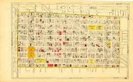
Sheet 14 : Main Street to Knight Street and Fifteenth Avenue to King Edward Street
Part of City of Vancouver fonds
Item is a section showing the area from Main Street to Knight Street and Fifteenth Avenue to King Edward Street. Includes streets and roads, blocks, lots, legal descriptions, parks, schools and businesses. Map is hand coloured to show tax sale property for sale, property with no water, street widening and drainage, replotting, reserved land for schools, reserved land for parks, sundry land, capital assets not including schools and parks, schools, and parks.
Vancouver (B.C.). Office of the City Engineer

Sheet 15 : Oak Street to Main Street and False Creek to Sixteenth Avenue
Part of City of Vancouver fonds
Item is a section showing Oak Street to Main Street and False Creek to Sixteenth Avenue. Includes streets and roads, blocks, lots, legal descriptions, railways, schools, monastery, Vancouver General Hospital and City Hall. Indicates crown land leased to the C.P.R. Map is hand coloured to show tax sale property for sale, property with no water, street widening and drainage, replotting, reserved land for schools, reserved land for parks, sundry land, capital assets not including schools and parks, schools, and parks.
Vancouver (B.C.). Office of the City Engineer
Chevron Stage at various events - contact sheets
File consists of fifteen contact sheets with a total of 527 images pertaining to the June 13th event in Gastown (2011-010.2447 to 2011-010.2451); Dragon Boat, June 14 (2011-010.2452); a June 15th Beaux Gestes '86 event downtown (2011-010.2453 and 2011-010.2454); Tea Party at City Hall, June 20 (2011-010.2455); Chevron Picnic, June 21 (2011-010.2456 to 2011-010.2457); Party in the Park Tour at Kensington Park, June 22 (2011-010.2458 amd 2011-010.2460); the Scandinavian Fest & Park Party, June 21-22 (2011-010.2460 and 2011-010.2461); and unidentifed performances (2011-010.2459).
Chevron Stage at Volunteer Park / Sun Run, April 1986
File consists of seven prints relating to the dedication of Volunteer Park on April 19, 1986 (2011-010.2252 to 2011-010.2255), the Vancouver Sun Run on April 20, 1986 (2011-010.2256 and 2011-010.2257), and the parade at the April 6, 1986 birthday party (2011-010.2251). Individuals identified are Mayor Michael Harcourt and Vancouver Centennial Commission Chairman Michael Francis.

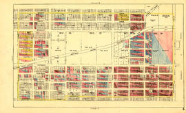
Sheet 19 : Maple Street to Richards Street and Drake Street to Third Avenue
Part of City of Vancouver fonds
Item is a section showing Maple Street to Richards Street and Drake Street to Third Avenue. Includes streets, roads, blocks, lots, legal descriptions, parks, schools, the Burrard and Granville Street Bridges, C.P.R. right-of-ways, the Squamish Band reserve, C.P.R. leases and property, and government reserve. Map includes Granville Island. Map is hand coloured to show tax sale property for sale, property with no water, street widening and drainage, replotting, reserved land for schools, reserved land for parks, sundry land, capital assets not including schools and parks, schools, and parks.
Vancouver (B.C.). Office of the City Engineer

Sheet 1: Slocan Street to Boundary Road and Triumph Street to Burrard Inlet
Part of City of Vancouver Archives technical and cartographic drawing collection
Item is a section showing the area bound by Slocan Street, Boundary Road, Triumph Street and the waterfront. Includes streets, roads, railways, blocks, lots, legal descriptions, quit claims, leases, parks and businesses along the waterfront.
Vancouver (B.C.). Office of the City Engineer

Sheet 2: Slocan Street to Boundary Road and Charles Street to Triumph Street
Part of City of Vancouver Archives technical and cartographic drawing collection
Sheet is a section showing the area from Slocan Street to Boundary Road and Charles Street to Triumph Street. Includes streets, roads, blocks, lots, legal descriptions, parks, schools, and retirement homes.
Vancouver (B.C.). Office of the City Engineer

Sheet 3 : Slocan Street to Boundary Road and Seventh Avenue to Charles Street
Part of City of Vancouver Archives technical and cartographic drawing collection
Item is a section showing the area from Slocan Street to Boundary Road and Seventh Avenue to Charles Street. Includes streets and roads, blocks, lots, legal descriptions, parks and schools.
Vancouver (B.C.). Office of the City Engineer

Sheet 4 : Slocan Street to Boundary Road and Seventh Avenue to Seventeenth Avenue
Part of City of Vancouver Archives technical and cartographic drawing collection
Item is a section showing the area from Slocan Street to Boundary Road and Seventh Avenue to Seventeenth Avenue. Includes streets and roads, blocks, lots, legal descriptions, railways, parks and schools.

Sheet 5 : Slocan Street to Boundary Road and Seventeenth Avenue to Twenty-ninth Avenue
Part of City of Vancouver Archives technical and cartographic drawing collection
Item is a section showing the area from Slocan Street to Boundary Road and Seventeenth Avenue to Twenty-ninth Avenue. Includes streets and roads, blocks, lots, legal descriptions, railways, parks, schools and the Vancouver Preventorium (for tuberculosis patients).
Vancouver (B.C.). Office of the City Engineer

Sheet 6 : Knight Street to Slocan Street and Eighteenth Avenue to Twenty-ninth Avenue
Part of City of Vancouver Archives technical and cartographic drawing collection
Item is a section showing the area from Knight Street to Slocan Street and Eighteenth Avenue to Twenty-ninth Avenue. Includes streets and roads, blocks, lots, legal descriptions, railways, parks and schools. Some annotations have been made in pencil.
Vancouver (B.C.). Office of the City Engineer

Sheet 7 : Clark Drive to Slocan Street and Seventh Avenue to Eighteenth Avenue
Part of City of Vancouver Archives technical and cartographic drawing collection
Item is a section showing the area from Clark Drive to Slocan Street and Seventh Avenue to Eighteenth Avenue. Includes streets and roads, blocks, lots, legal descriptions, railways, parks and schools. Some annotations have been made in green ink.
Vancouver (B.C.). Office of the City Engineer

Sheet 8 : McLean Drive to Slocan Street and William Street to Seventh Avenue
Part of City of Vancouver Archives technical and cartographic drawing collection
Item is a section showing the area from McLean Drive to Slocan Street and William Street to Seventh Avenue. Includes streets and roads, blocks, lots, legal descriptions, railways, parks, schools and some businesses.
Vancouver (B.C.). Office of the City Engineer