Add to clipboard
Dial map of Greater Vancouver
Sectional map and street directory of Vancouver : Dial map of the city of Vancouver including adjacent municipalities
Add to clipboard
Sectional map and street directory of Vancouver : Dial map of the city of Vancouver including adjacent municipalities
Add to clipboard
Dial map of Greater Vancouver and suburbs
Dial map of the city of Vancouver including the adjacent municipalities
Add to clipboard
Dial map of the city of Vancouver including the adjacent municipalities
Add to clipboard
Dial map of Greater Vancouver and suburbs
Indexed map of Greater Vancouver
Add to clipboard
Indexed map of Greater Vancouver
Add to clipboard
Indexed map of Greater Vancouver showing distances from Bekins building
Add to clipboard
Indexed map of Greater Vancouver : map cover and advertisements
Street map of Greater Vancouver
Add to clipboard
Street map of Greater Vancouver
Free map of Vancouver, New Westminster and surroundings
Add to clipboard
Free map of Vancouver, New Westminster and surroundings
Add to clipboard
Free map of Vancouver, New Westminster and surroundings
Map of Greater Vancouver including streets, districts, schools, churches, shopping centres, parks, etc.
Add to clipboard
Map of Greater Vancouver including streets, districts, schools, churches, shopping centres, parks, etc.
Add to clipboard
Plan of the City of Vancouver. Western Terminus of the Canadian Pacific Railway
Vancouver Harbour : plan of south shore, Burrard Inlet between Heatley Ave. and Victoria Dr.
Add to clipboard
Vancouver Harbour : plan of south shore, Burrard Inlet between Heatley Ave. and Victoria Dr.
Add to clipboard
Plan no. 2 : showing city distribution system, pressure districts, fire stations and water flow test locations : City of Vancouver, British Columbia
Cityscape: A map of downtown Vancouver
Add to clipboard
Cityscape: A map of downtown Vancouver
Add to clipboard
Plan of Greater Vancouver, British Columbia
Add to clipboard
Vancouver sheet, British Columbia
Add to clipboard
Pictorial map of Greater Vancouver showing dates of settlement in specific areas and opening dates of regional landmarks
Add to clipboard
Plan of part of sub-division of district lot 540, South Vancouver, provincial government property
Add to clipboard
Plan of provincial government property being a portion of townsite of Vancouver and sub-division of lot 540, group 1, New Westminster District, B.C., to be sold by public auction at Vancouver, B.C.
Circulation map of Greater Vancouver by telephone exchange areas
Add to clipboard
Circulation map of Greater Vancouver by telephone exchange areas
Add to clipboard
Map of Vancouver Sun's city circulation
Add to clipboard
Circulation map of Greater Vancouver : today's market data on Vancouver
Add to clipboard
General development plan, Exhibition Park, Vancouver, B.C.
Add to clipboard
Pacific National Exhibition grounds plan : parking available for proposed arena
Add to clipboard
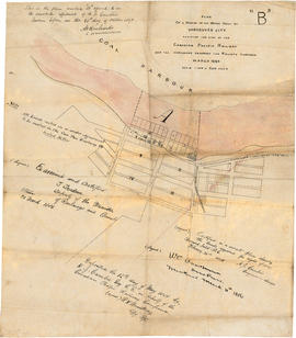
Town-site of Hastings
Add to clipboard
Plan 3
Add to clipboard
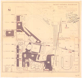
Pacific National Exhibition grounds plan
Add to clipboard
B.C. Electric guide to Greater Vancouver : Richmond transit system, downtown Vancouver transit system, street index, and general information
Street map of Vancouver, Burnaby, New Westminster, British Columbia
Add to clipboard
Street map of Vancouver, Burnaby, New Westminster, British Columbia
Add to clipboard
Street map of Greater Vancouver showing distances from Bekins building
Add to clipboard
Street map of Greater Vancouver : map cover, street index and advertisements
Add to clipboard
Plan of a portion of the water front of Vancouver city
Vancouver Harbour [sectional map]
Add to clipboard
Vancouver Harbour [sectional map]
City of Vancouver, Vancouver, British Columbia : sectional maps (printed 1970)
Add to clipboard
City of Vancouver, Vancouver, British Columbia : sectional maps (printed 1970)
Add to clipboard
District lot boundaries with the City of Vancouver, British Columbia, D.L. map 40
Add to clipboard
Index to 400 ft. scale section maps, City of Vancouver, British Columbia, index map 40
Add to clipboard
[Sheet 4 : Chilco Street to Burrard Street and Robson Street to Deadmans Island]
Add to clipboard
[Sheet 5 : Stanley Park to Nicola Street and English Bay Beach to Robson Street]
Add to clipboard
[Sheet 6 : Nicola Street to Beatty Street and English Bay Beach to Georgia Street]
Add to clipboard
[Sheet 7 : Burrard Street to Main Street and Georgia Viaduct to Burrard Inlet]
Add to clipboard
[Sheet 8 : Main Street to Clark Drive and Alexander Street to Burrard Inlet]
Add to clipboard
[Sheet 9 : Main Street to Clark Drive and Prior Street to Burrard Inlet]
Add to clipboard
[Sheet 10 : Clark Drive to Nanaimo Street and Frances Street to Burrard Inlet]
Add to clipboard
[Sheet 11 : Wall Street to Rupert Street and McGill Street to Burrard Inlet]
Add to clipboard
[Sheet 12 : Nanaimo Street to Cassiar Street and Pender Street to McGill Street]
Add to clipboard
[Sheet 13 : Rupert Street to Gilmore Avenue and Eton Street to Burrard Inlet]
Add to clipboard
[Sheet 14 : Cassiar Street to Carleton Avenue and Pender Street to Eton Street]
Add to clipboard
[Sheet 15 : Rupert Street to Carleton Avenue and Kitchener Street to Pender Street]


![[Sheet 4 : Chilco Street to Burrard Street and Robson Street to Deadmans Island]](/uploads/r/null/9/4/9482209e02b8dc04c79ef404276e1d40bcbb4fab0330b4aa744e352ae9440921/5597738a-70b2-4cfc-a802-6a076987c33d-MAP339_142.jpg)
![[Sheet 5 : Stanley Park to Nicola Street and English Bay Beach to Robson Street]](/uploads/r/null/1/d/1daf1ff2196704e4e82a6b5c7476ee3e8a46b4e0740f3c37f3f58813f5f8b5f0/ee3a2706-4ebe-4ee8-b4db-da89840c7f89-MAP339_142.jpg)
![[Sheet 6 : Nicola Street to Beatty Street and English Bay Beach to Georgia Street]](/uploads/r/null/f/2/f2effc97084427c0bd73bae3566d3ad910caaa6e7fb3e5ed9f3ece81bd2ac0a1/f2cc48a6-1195-4dd8-8227-71d36d1791bb-MAP339_142.jpg)
![[Sheet 7 : Burrard Street to Main Street and Georgia Viaduct to Burrard Inlet]](/uploads/r/null/c/d/cd235086cbaf81487b8784fb32b6ef913f4fe27305678cd1961adf506324c250/8f72f6bd-1013-48ad-a56c-e6269cb6f5a8-MAP339_142.jpg)
![[Sheet 8 : Main Street to Clark Drive and Alexander Street to Burrard Inlet]](/uploads/r/null/a/1/a10fe461f7836acc659d886d1888eef9d17bfc99d33e474c29ae025ed531b50c/e81d36a6-a6c1-40a5-852b-ef52bfbdb8dd-MAP339_142.jpg)
![[Sheet 9 : Main Street to Clark Drive and Prior Street to Burrard Inlet]](/uploads/r/null/c/a/ca4b4713bea0118fec812e6258afe5c1efa039db74073214703001a47b00f122/5e0d243a-99ae-42aa-8bb3-4a1abe9e1209-MAP339_142.jpg)
![[Sheet 10 : Clark Drive to Nanaimo Street and Frances Street to Burrard Inlet]](/uploads/r/null/b/1/b1095cb557ec54cc1f1894faad721045c1eaa4b11b76e6c08ec0349a9138f078/f41cbf9e-303f-40cd-8ef4-f0699363222c-MAP339_142.jpg)
![[Sheet 11 : Wall Street to Rupert Street and McGill Street to Burrard Inlet]](/uploads/r/null/e/b/eb84fb8de9ca2e1644a2e39bcbaad5253c563e8716cf25114e675fb7d40365ea/0935fb81-4662-411a-bdfd-c9823c7fb82b-MAP339_142.jpg)
![[Sheet 12 : Nanaimo Street to Cassiar Street and Pender Street to McGill Street]](/uploads/r/null/6/0/603c1cdc3adb1f0dec963bbd885c378ce1e23c71767cb0b461ef6ccc54807a5a/49483dc1-d90f-4a82-86cd-3c7a09f2ddae-MAP339_142.jpg)
![[Sheet 13 : Rupert Street to Gilmore Avenue and Eton Street to Burrard Inlet]](/uploads/r/null/f/0/f03aaa2671556fb722cf612a9736c0a6b919aff4af5a9dbe048dd93863af5773/30eb2a4c-b404-4552-81da-7461e4aacfaa-MAP339_142.jpg)
![[Sheet 14 : Cassiar Street to Carleton Avenue and Pender Street to Eton Street]](/uploads/r/null/a/4/a404347152c9328da5ec443862d19bc937a2199f1ce3cde01729819bfd1272d2/5ec2b15f-3c41-4c16-8567-f00ced74929f-MAP339_142.jpg)
![[Sheet 15 : Rupert Street to Carleton Avenue and Kitchener Street to Pender Street]](/uploads/r/null/b/7/b7b353e0ba4ef92f21d8b4148594896da61b022d62168ec30d592e80b71eb373/6461e269-e3e0-4cad-b202-be701b9eac5b-MAP339_142.jpg)