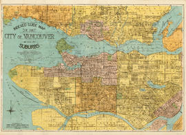
Print preview Close

Showing 1440 results

Archival description
City of Vancouver Archives technical and cartographic drawing collection With digital objects
Print preview View:

Indexed guide map of the city of Vancouver and suburbs

Part is a map showing district lots, blocks, and boundaries between the City of Vancouver, Point Grey, South Vancouver, Burnaby, New Westminster, and parts of Richmond, North Vancouver and West Vancouver. Concentric circles indicate the distance in miles from the intersection of Main Street and Hastings Street in intervals of 1/2 mile.

Information concerning the City and District of New Westminster and the Province of British Columbia

Part is the text side of a pamphlet. This part contains information concerning the city and district of New Westminster, with individual panels on the municipalities of Delta, Chilliwhack [sic], Surrey, Langley, and Delta, and the City of New Westminster, the town of Harrison Hot Springs and the province.

Inset maps and indexes

Part is the verso side of the pamphlet, which includes a street index, list of places of general interst and their location on on the main map, a list of B.C.E.R. routes, and an index of schools shown on the map. The page includes two inset maps, one of downtown Vancouver and one of Richmond, including a road index.

Insurance plan of Port Coquitlam : key plan and sheet 1

Part contains the key plan for the insurance plan of Port Coquitlam, an inset map of the area bounded by Shaughnessy Street, Central Avenue, and Rindall Avenue, and a section of the insurance plan covering Dewdney Trunk Road where it crosses the Coquitlam River. Map shows legal descriptions, street widths, building dimensions and types (dwelling, office, industrial, other commercial use), names of businesses, and other features of the built environment relevant to insurance claims.

Insurance plan of Port Coquitlam : sheet 2

Part contains a section of the insurance plan covering the area bounded by the Coquitlam River, an unnamed creek, Dewdney Trunk Road, and Whyte Avenue. Map shows legal descriptions, street widths, building dimensions and types (dwelling, office, industrial, other commercial use), names of businesses, and other features of the built environment relevant to insurance claims.

Insurance Plan of Port Coquitlam : sheet 3

Part contains a section of the insurance plan covering the area bounded by an unnamed creek, Kingsway Avenue, and Atkins Avenue. Map shows legal descriptions, street widths, building dimensions and types (dwelling, office, industrial, other commercial use), names of businesses, and other features of the built environment relevant to insurance claims.

Insurance Plan of Port Coquitlam : sheet 4

Part contains a section of the insurance plan covering the area bounded by Chester Street, Cambridge Street, Grant Avenue, and Suffolk Avenue. Map shows legal descriptions, street widths, building dimensions and types (dwelling, office, industrial, other commercial use), names of businesses, and other features of the built environment relevant to insurance claims.

Introductory Notes

Item is a sheet containing the following information for all volumes of the map: Table of Contents (including information on map symbols); General Information (on the land registration system in British Columbia and District Lots); a list of land registry districts in British Columbia; information on the process of applying for registration of plans; Certificate of Title process; a definition of Indefeasible Title; a list of registration fees, and technical requirements for subdivision maps.

It might have been Albert City, 1858, New Georgia 1792 : it was Granville, 1870, British Columbia, 1871 : it is Vancouver, 1886, British Columbia, 1871 : it is Vancouver, 1886, Canada, 1867

Item is a map compiled and drawn by J.S. Matthews, City Archivist showing historic place names of Vancouver and the North Shore and listing some historic Burnaby names. A note in the bottom left hand corner reads: "Memorada. The precise location of "Albert City" is unknown, Narveaz was first; 150 years passed before his name was given to a landmark. His vessel's name "Santa Saturnina" has never been applied to anything at all."

Location of ferry pedestrian subway, Vancouver, B.C.

Item is an architectural drawing depicting a subway (underground) pedestrian walkway to run underneath the Canadian Pacific Railway tracks, linking Alexander Street to the North Vancouver Ferry Co. dock. Ramp grades are indicated. The drawing shows the location of the North Vancouver Ferry Company; Evans, Coleman and Evans Limited; and the Grand Trunk Pacific Railway Company.

Vancouver (B.C.). Engineer's Office

Lot numbers, boundaries, railway lines and street names in the municipality of Point Grey

Primary map shows lot numbers, boundaries, railway lines and street names in the municipality of Point Grey from 16th Avenue in the north to the Fraser River in the south and from Ontario Street in the east to Blanca Drive in the west. A smaller map in the bottom left-hand corner of the item shows the north west portion of Point Grey.

Map and Guide to Vancouver Street Car and Interurban Lines

Part is the front side of an informational pamphlet published by the BC Electric Railway Co. regarding City streetcar routes and interurban lines, golf and country clubs, city trips, interurban trips, motor coach trips, stations, ferries and docks, bathing beaches, public parks, North Shore canyons and parks, athletic and amusement parks.

Map of a portion of British Columbia

Item is a map showing exploration routes by Lieutenant Palmer, R.E., May and June 1859; Lieutenant Mayne, R.N., May 1859; and Lieutenant Palmer, R.E., Sept. & Oct. 1859. The map also shows "practicable roads" in the southwestern portion of British Columbia. Annotations are colour added to the map to more easily distinguish the different routes depicted.

Map of British Columbia

Item is an administrative map which show the locations of government offices, including: mining recording offices, trading posts, E. & N. Ry. land grants, railways, and highways. Text includes: Adminstration lists (e.g. Supreme Court County Courts, radio stations, Customs and Excise, index of post offices, etc.); Distance tables [for coast, roads, railways, world]; The population of city, district and village municipalities in British Columbia [from the] census, 1931. Map also includes an inset detailing the Strait of Georgia between Victoria and Vancouver.

Results 251 to 300 of 1440