- AM1594---: 1987-017.03
- Item
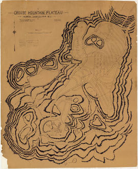
- [ca. 1930?]
Part of City of Vancouver Archives technical and cartographic drawing collection
Item is a floor plan. The drawing has the following attestation: G.L. Warner Ltd., 1410 Royal Bank Building, Vancouver, B.C., but as this company was an insurance broker and real estate agents, it is unlikely they were responsible for creating the drawing.