![Plate 135 [Quebec Street to Fourteenth Avenue to Manitoba Street to Seventeenth Avenue]](/uploads/r/null/e/2/c/e2cb462b960ca9d4c0d5b97180db2dd920b833da6c49e5d51c8e95bf106ef7db/87724ebf-1228-4869-bb46-03f26e327563-1974-100_142.jpg)
Plate 135 [Quebec Street to Fourteenth Avenue to Manitoba Street to Seventeenth Avenue]
- AM1594-MAP 625-: 1974-100.39
- Item
- Sept. 1905
Part of City of Vancouver Archives technical and cartographic drawing collection
1440 results with digital objects Show results with digital objects
Plate 135 [Quebec Street to Fourteenth Avenue to Manitoba Street to Seventeenth Avenue]
Part of City of Vancouver Archives technical and cartographic drawing collection
![Plate 140 [Block east of Pine Street to Kitsilano Indian Reserve to Cedar Street to Third Avenue]](/uploads/r/null/7/e/8/7e8970e4b38be59229b38f8b6eb9833bfce0ac4b6b5ab287ecc09ff682cebecc/42fb5df2-2281-4cc9-a83f-44f82f9e47c3-1974-100_142.jpg)
Plate 140 [Block east of Pine Street to Kitsilano Indian Reserve to Cedar Street to Third Avenue]
Part of City of Vancouver Archives technical and cartographic drawing collection
![Plate 141 [Granville Street to False Creek to block west of Fir Street to Third Avenue]](/uploads/r/null/b/2/5/b255e765c266c20bfe0a9abc3dde1bf65002ca267675bad2dadafa4474df0196/b7dbabfa-7bf6-4bd3-b4e0-15d4a69b2877-1974-100_142.jpg)
Plate 141 [Granville Street to False Creek to block west of Fir Street to Third Avenue]
Part of City of Vancouver Archives technical and cartographic drawing collection
![Plate 142 [Block east of Yew Street to Third Avenue to Vine Street to Sixth Avenue]](/uploads/r/null/4/1/b/41bfdfad990b2c36b8c65458c9a335d7188fa3e2385c910acd6f933a1f61eea9/b93009cb-1ffe-4031-a009-d2f37f20b9c1-1974-100_142.jpg)
Plate 142 [Block east of Yew Street to Third Avenue to Vine Street to Sixth Avenue]
Part of City of Vancouver Archives technical and cartographic drawing collection
![Plate 149 [Maple Street to Sixth Avenue to block west of Arbutus Street to Ninth Avenue]](/uploads/r/null/1/f/f/1ff5adea07e72b47fb8589cf72b5837f3f0cb33659dab5cf8869d5a88d99bde1/af236417-5448-45f0-93a1-6e86f77ec05e-1974-100_142.jpg)
Plate 149 [Maple Street to Sixth Avenue to block west of Arbutus Street to Ninth Avenue]
Part of City of Vancouver Archives technical and cartographic drawing collection
![Plate 151 [Pine Street to Sixth Avenue to block west of Cedar Street to Ninth Avenue]](/uploads/r/null/e/4/9/e49218d46361f18de15f4b73198cc7b1fda01b9493e8cf55080a219b228f21dd/90857757-8cb5-40e3-89a3-1b9cb3f4107c-1974-100_142.jpg)
Plate 151 [Pine Street to Sixth Avenue to block west of Cedar Street to Ninth Avenue]
Part of City of Vancouver Archives technical and cartographic drawing collection
![Plate 155 [Spruce Street to Sixth Avenue to block west of Alder Street to Ninth Avenue]](/uploads/r/null/6/1/d/61d627b8bf8255c91caa4dae5c1414b7dea029c2d65ae523e8184113877d5762/9e7d5e21-01bf-448f-8037-73dd4abc4549-1974-100_142.jpg)
Plate 155 [Spruce Street to Sixth Avenue to block west of Alder Street to Ninth Avenue]
Part of City of Vancouver Archives technical and cartographic drawing collection
![Plate 157 [Willow Street to Sixth Avenue to block west of Laurel Street to Ninth Avenue]](/uploads/r/null/9/5/9/95917226a7f84bd48d88028f6821d6cb5ccdb9dc3b332600d85491dafd7539e6/e2de822d-869f-4fe6-b52b-84c3f4c8baac-1974-100_142.jpg)
Plate 157 [Willow Street to Sixth Avenue to block west of Laurel Street to Ninth Avenue]
Part of City of Vancouver Archives technical and cartographic drawing collection
![Plate 161 [Vancouver Lumber Co. site]](/uploads/r/null/8/5/2/852127f39051bf85e540ef01942067e3bc3fcf3dd7a1eb053622d2bd87407c8e/d10bf21c-a276-437b-9032-81dea28defdd-1974-100_142.jpg)
Plate 161 [Vancouver Lumber Co. site]
Part of City of Vancouver Archives technical and cartographic drawing collection
![Plate 163 [Key Plan of North Vancouver]](/uploads/r/null/e/1/d/e1d59c4aba0a20f0522dd57d1ecfbcc6fa0e15d2cb581616d819932b7b4485b7/be98b40c-82d0-4d47-97d2-e5bc54e3e904-1974-100_142.jpg)
Plate 163 [Key Plan of North Vancouver]
Part of City of Vancouver Archives technical and cartographic drawing collection
![Plate 164 [Lonsdale Avenue to Second Street to Chesterfield Avenue to Burrard Inlet]](/uploads/r/null/b/c/5/bc5801cb1cab9f718c08d5e85247acf3c6c6d41621bd633be9636327b722a9cd/db55d2fa-bc36-4407-a98b-9c062774aa12-1974-100_142.jpg)
Plate 164 [Lonsdale Avenue to Second Street to Chesterfield Avenue to Burrard Inlet]
Part of City of Vancouver Archives technical and cartographic drawing collection
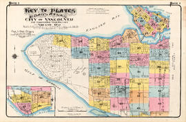
Plate 1: Key to Plates. Goad's Atlas. City of Vancouver and Surrounding Municipalities. Volume One
Part of City of Vancouver Archives technical and cartographic drawing collection
Item is a map which acts as a key to the other maps in the volume. The map depicts which areas are depicted in each of the smaller-scale maps.
![Plate 8: West End [Cardero Street - Barclay Street - Park Road - Beach Avenue - Davie Street]](/uploads/r/null/6/d/6/6d680461017be540974f2eb8ba9641e6ea703be5860e413e63fdfe34f65ceead/e073c970-9088-45fe-8202-64066fbe2941-MAP342a_142.jpg)
Plate 8: West End [Cardero Street - Barclay Street - Park Road - Beach Avenue - Davie Street]
Part of City of Vancouver Archives technical and cartographic drawing collection
Item is a map depicting an area bounded by the following streets: Cardero Street (west side only) to Barclay Street (south side only) to Park Road to Beach Avenue to Davie Street (north side only).
Plate 14: West End - southeast corner and BC Electric Railway yards
Part of City of Vancouver Archives technical and cartographic drawing collection
Item is a map in two sections. The first section depicts the area bounded by the following streets: the west side of False Creek to the CPR private lane at the end of Nelson Street to Homer Street (east side only) to Drake Street and the north end of the CPR yards and roundhouse. The second section depicts the area bounded by Carrall Street (west side only to Hastings Street West (south side only) to Abbott Street (east side only) to the BC Electric Railway Company yards and adjacent buildings west of Carrall Street.
![Plate 15: West End [Broughton Street - Burnaby Street/Davie Street - Denman Street - False Creek]](/uploads/r/null/1/3/0/13083b6fde232491e843c0bb62a3e683ea30651590e365309e8d1f17429acfa1/edde3573-9350-4c2b-8fee-5ac5e153d498-MAP342a_142.jpg)
Plate 15: West End [Broughton Street - Burnaby Street/Davie Street - Denman Street - False Creek]
Part of City of Vancouver Archives technical and cartographic drawing collection
Item is a map depicting an area bounded by the following streets: Broughton Street (west side only) to Burnaby Street (south side only, Broughton to Cardero streets) and Davie Street (south side only, Cardero to Denman streets) to Denman Street (east side only) to False Creek.
![Plate 19: Point Grey [DL 176 - English Bay - Blanca Drive - Sixth Avenue]](/uploads/r/null/9/0/9/909403abc0abc4ea9b01b1fe9828873551fc26e82dc2e7e8f84af526c1a137b6/34b7af86-7d81-4ed5-9c84-a350059fc9b2-MAP342a_142.jpg)
Plate 19: Point Grey [DL 176 - English Bay - Blanca Drive - Sixth Avenue]
Part of City of Vancouver Archives technical and cartographic drawing collection
Item is a map depicting an area bounded by the following streets: the northwest corner of District Lot 176 to English Bay to Blanca Drive (east side only) to Sixth Avenue (north side only).
![Plate 25: Fairview [Oak Street - False Creek - Fourth Avenue - Cypress Street]](/uploads/r/null/2/7/2/2726be0d8aa2ac0291e1b47b1349d50e381b1f9dec983a5584305f99303e4b0b/dba924f1-ac60-4a66-ba3e-98b7efd7357d-MAP342a_142.jpg)
Plate 25: Fairview [Oak Street - False Creek - Fourth Avenue - Cypress Street]
Part of City of Vancouver Archives technical and cartographic drawing collection
Item is a map depicting an area bounded by the following streets: Oak Street (west side only) to False Creek and Fourth Avenue West (south side only) to Cypress Street (and 1/2 block immediately west)
Part of City of Vancouver Archives technical and cartographic drawing collection
Item is a map depicting an area bounded by the following streets: Maple Street to Nineteenth Avenue/18th Avenue to Carnarvon Street (east side only) to Twenty-ninth Avenue (north side only).

Part of City of Vancouver Archives technical and cartographic drawing collection
Item is a map depicting an area bounded by the following streets: Maple Street (incluing 2/3 block immediately east) to Twenty-ninth Avenue (south side only) to Carnarvon Street (east side only) to Thirty-ninth Avenue (north side only).

Part of City of Vancouver Archives technical and cartographic drawing collection
Item is a map depicting an area bounded by the following streets: Ontario Street to Essex Street/Sixty-first Avenue West to Fremlin Avenue to Townsend Road [now West 70th Avenue].
Part of City of Vancouver Archives technical and cartographic drawing collection
Item is a map depicting an area bounded by the following streets: Blanca Drive to English bay to the northeast corner of the University Endowment Lands to Fourth Avenue.
Part of City of Vancouver Archives technical and cartographic drawing collection
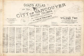
File consists of the second volume of Goad's Atlas of Vancouver, a series of fire insurance maps.
Part of City of Vancouver Archives technical and cartographic drawing collection
Item is a sheet containing an index to all streets represented in Volume 2, in alphabetical order, with Plate number(s).
![Plate 65: Waterfront [Dunlevy Avenue - Burrard Inlet - Carrall Street - Alexander Street]](/uploads/r/null/7/2/c/72c683aaa1bbadfa6f2c4b0feda4d57c2bafa66267baf6282fef005407cde75b/41624a12-5460-4f35-9ba3-fb41fc638c6d-MAP342b_142.jpg)
Plate 65: Waterfront [Dunlevy Avenue - Burrard Inlet - Carrall Street - Alexander Street]
Part of City of Vancouver Archives technical and cartographic drawing collection
Item is a map depicting an area bounded by the following streets: Dunlevy Avenue (west side only) to Burrard Inlet to Carroll Street (east side only) to Alexander Street (north side only).
![Plate 66: Waterfront [Hawks Avenue - Burrard Inlet - Railway/Alexander Street]](/uploads/r/null/d/c/4/dc440a03c6a086034e7dfa3a858bd234b53182da15fe4f1c1e0ded188a68deaa/c8e7ca9f-c845-4f43-9611-81770d1714e0-MAP342b_142.jpg)
Plate 66: Waterfront [Hawks Avenue - Burrard Inlet - Railway/Alexander Street]
Part of City of Vancouver Archives technical and cartographic drawing collection
Item is a map depicting an area bounded by the following streets: Hawks Avenue to Burrard Inlet to Dunlevy Avenue (east side only) to Railway Street/Alexander Street (north side only) and includes the Hastings Sawmill site.
![Plate 69: Strathcona [Dunlevy Avenue - Hastings Street - Carrall Street - Union Street]](/uploads/r/null/f/f/c/ffcf222a9bf6fab0cd3ea82b3420fc4f37bad16058188497178263918754c7b8/33c1a3bf-91b9-40b2-ad5f-4fd60ba6befe-MAP342b_142.jpg)
Plate 69: Strathcona [Dunlevy Avenue - Hastings Street - Carrall Street - Union Street]
Part of City of Vancouver Archives technical and cartographic drawing collection
Item is a map depicting an area bounded by the following streets: Dunlevy Avenue (west side only) to Hastings Street East (south side only) to Carrall Street (east side only) to Union Street (north side only).
![Plate 73: Grandview-Woodland [Clark Drive - Powell Street - Campbell Avenue - Keefer Street]](/uploads/r/null/5/0/7/507ddc3ef1aa399c73ca84e2b690640648ab01981fd50179861686e37317e9af/f1b0ab6a-3f8b-40a9-a9a6-b38cc96fe19b-MAP342b_142.jpg)
Plate 73: Grandview-Woodland [Clark Drive - Powell Street - Campbell Avenue - Keefer Street]
Part of City of Vancouver Archives technical and cartographic drawing collection
Item is a map depicting an area bounded by the following streets: Clark Drive (including 2/3 block immediately east) to Powell Street (south side only) to Campbell Avenue (east side only) to Keefer Street (north side only).
![Plate 75: Grandview-Woodland [Odlum Drive - Keefer Street - Campbell Avenue - Napier Street]](/uploads/r/null/d/d/f/ddf99a27b6bc1077ec66de8758edf2a9f41a7388e6184e8c9e82ef5d4cf9fd57/88852658-c386-40f2-a197-0595adac3e51-MAP342b_142.jpg)
Plate 75: Grandview-Woodland [Odlum Drive - Keefer Street - Campbell Avenue - Napier Street]
Part of City of Vancouver Archives technical and cartographic drawing collection
Item is a map depicting an area bounded by the following streets: Odlum Drive (west side only) to Keefer Street (now Frances Street) (south side only) to Campbell Avenue (east side only) to Napier Street (north side only).
![Plate 77: Grandview-Woodland [Victoria Drive - Burrard Inlet - Hawks Avenue - Powell/Pandora Street]](/uploads/r/null/f/b/9/fb91bc9dfc59ea435e57cf3d9999d29b49bed5605a2da9ef6dd4be1a84724e7c/bcf34a8c-a432-45d4-b8df-20f4420ee3bf-MAP342b_142.jpg)
Plate 77: Grandview-Woodland [Victoria Drive - Burrard Inlet - Hawks Avenue - Powell/Pandora Street]
Part of City of Vancouver Archives technical and cartographic drawing collection
Item is a map depicting an area bounded by the following streets: Victoria Drive (west side only) to Burrard Inlet to Hawks Avenue to Powell Street/Pandora Street (north side only).
![Plate 79: Hastings-Sunrise [Boundary Road - Burrard Inlet - Renfrew Street - Pandora Street]](/uploads/r/null/4/4/5/4451afb6b7f7a82aa576e178f0b4a0513cebed2634ee040a086bfe8567cd026f/dd485ae3-a405-4ce1-b3d3-f919cedeabbb-MAP342b_142.jpg)
Plate 79: Hastings-Sunrise [Boundary Road - Burrard Inlet - Renfrew Street - Pandora Street]
Part of City of Vancouver Archives technical and cartographic drawing collection
Item is a map depicting an area bounded by the following streets: Boundary Road (west side only) to Burrard Inlet to Renfrew Street (east side only) to Pandora Street (north side only).
![Plate 85: Hastings-Sunrise [Boundary Road - Charles Street - Renfrew Street - Fifth Avenue]](/uploads/r/null/6/5/f/65f35b87dbff15ab0318d6f4aeaf673280f91790049238b06f2142733e611db3/f7918249-9c95-4c25-9d8c-06dec128faaf-MAP342b_142.jpg)
Plate 85: Hastings-Sunrise [Boundary Road - Charles Street - Renfrew Street - Fifth Avenue]
Part of City of Vancouver Archives technical and cartographic drawing collection
Item is a map depicting an area bounded by the following streets: Boundary Road (west side only) to Charles Street (south side only) to Renfrew Street (east side only) to Fifth Avenue Wast (north side only).

Part of City of Vancouver Archives technical and cartographic drawing collection
Item is a map depicting an area bounded by the following streets: Dock Street (now Windsor Street) (west side only) to Seventh Avenue East (south side only) to Ontario Street (east side only) to Sixteenth Avenue East/Fifteenth Avenue East (north side only)..
![Plate 90: Mount Pleasant [Dock Street - Fifteenth Avenue - Ontario Street - King Edward Avenue]](/uploads/r/null/1/4/a/14a723151dc29add34dd378781a27b78829657362f3dce469dffb0c264f8b9e6/1f2977a4-639f-4884-9997-fe2cfc8e0113-MAP342b_142.jpg)
Plate 90: Mount Pleasant [Dock Street - Fifteenth Avenue - Ontario Street - King Edward Avenue]
Part of City of Vancouver Archives technical and cartographic drawing collection
Item is a map depicting an area bounded by the following streets: Dock Street (now Windsor Street) (west side only) to Fifteenth Avenue East (south side only) to Ontario Street (east side only) to King Edward Avenue (north side only).

Part of City of Vancouver Archives technical and cartographic drawing collection
Item is a map depicting an area bounded by the following streets: Rupert Street (west side only) to Thirty-fifth Avenue East (south side only) to Victoria Drive (east side only) to Forty-sixth Avenue East (north side only).
Part of City of Vancouver Archives technical and cartographic drawing collection
Item is a map depicting an area bounded by the following streets: Victoria Drive (west side only) to Forty-seventh Avenue East (south side only) to Windsor Street (east side only) to Fifty-seventh Avenue East (north side only).
![Plate 110: Sunset [Windsor Street - River Avenue - Ontario Street - Fraser River]](/uploads/r/null/0/5/1/0517315aa9f84af3bc4f564f523aaf9e067d9b2cd00a4aa1ae4c0fdeafa3e930/1c54d499-8d65-47ea-8942-f6a78a82a9ae-MAP342b_142.jpg)
Plate 110: Sunset [Windsor Street - River Avenue - Ontario Street - Fraser River]
Part of City of Vancouver Archives technical and cartographic drawing collection
Item is a map depicting an area bounded by the following streets: Windsor Street (west side only) to River Avenue East (south side only) to Ontario Street (east side only) to the Fraser River.
![Plate 113: Killarney [Park Street - Sixty-seventh Avenue - Rupert Street - Fraser River]](/uploads/r/null/d/c/6/dc6f37ebae27a37b14cb5b18025ffac1646066b421e01663f748b244aca25200/8c3aa04a-1f90-4780-a260-048c78490ec5-MAP342b_142.jpg)
Plate 113: Killarney [Park Street - Sixty-seventh Avenue - Rupert Street - Fraser River]
Part of City of Vancouver Archives technical and cartographic drawing collection
Item is a map depicting an area bounded by the following streets: Park Street (now Boundary Road) (west side only) to Sixty-seventh Avenue East (south side only) to Rupert Street (east side only) to the Fraser River.

Vancouver Harbour, British Columbia
Part of City of Vancouver Archives technical and cartographic drawing collection
Item is a map adhered inside a leather presentation case made for Lord Tweedsmuir by the Vancouver Harbour Commissioners. The item was presented to Lord Tweedsmuir during a visit to Vancouver in 1936. Accompanying the map there is a booklet by the Vancouver Harbour Commissioners entitled "Interesting Facts about the Port of Vancouver" and a note to Henry "Budge" Bell-Irving from John Tweedsmuir. The map shows English Bay and Burrard Inlet with soundings in feet. Map shows district lots and street names from Lighthouse Park and the University of British Columbia to the border of the Municipality of Coquitlam. Includes inset maps of North Arm Burrard Inlet and Vancouver Island.

Part of City of Vancouver Archives technical and cartographic drawing collection
Item consists of a large scale site plan, depicting a proposed development in False Creek [Expo 86?] annotated on top of what appears to be a City planning map. The plan appears to depict part of the Concord Pacific development.
![The Seechelt [Sechelt] Forest](/uploads/r/null/e/6/d/e6d1e8d1a7613c8e7ce050434f42ef80f8e00ca339edc6e23dc578f9a4154957/c9ad5fbf-94a8-4925-8b43-b0845d5bd699-MAP54_142.jpg)
Part of City of Vancouver Archives technical and cartographic drawing collection
Item is a topographical map of the Seechelt Forest surrounding Jervis Island and Princess Louisa Inlet. Includes elevations, roads, and buildings, as well as information regarding vegetation, forestry, and land use.
British Columbia. Department of Lands and Forests. Forest Service
Plan of South Shore, Burrard Inlet between Granville and Heatley Avenue
Part of City of Vancouver Archives technical and cartographic drawing collection
Plan of South Shore, Burrard Inlet in front of lots 214 and 215 [Burnaby]
Part of City of Vancouver Archives technical and cartographic drawing collection
Plan of South Shore, Burrard Inlet in front of lot 203 [Port Moody]
Part of City of Vancouver Archives technical and cartographic drawing collection
Plan of North Shore, Burrard Inlet between D.L. 349 and D.L. 226
Part of City of Vancouver Archives technical and cartographic drawing collection
Plan of North Shore, Burrard Inlet in front of D.L. 611-469 and I.R. No. 3
Part of City of Vancouver Archives technical and cartographic drawing collection
Plan of North Shore, Burrard Inlet between Fell Avenue and St. Andrews
Part of City of Vancouver Archives technical and cartographic drawing collection
Part of City of Vancouver Archives technical and cartographic drawing collection
File consists of reproductions of sections of at least three different street maps of Vancouver. The sections show streets, railways, schools and main features of interest.

Sheet 1 : Boundary Road to Burrard Inlet to Templeton Drive to Charles Street
Part of City of Vancouver Archives technical and cartographic drawing collection
Item is a reproduction of a section of an unknown map.
Sheet 4 : Boundary Road to 24th Avenue to Victoria Drive to Forty-ninth Avenue
Part of City of Vancouver Archives technical and cartographic drawing collection
Item is a reproduction of a section of an unknown map.
Sheet 6 : Penticton Street to Burrard Inlet to Princess Avenue to William Street
Part of City of Vancouver Archives technical and cartographic drawing collection
Item is a reproduction of a section of an unknown map.