
Greater Vancouver sewerage and drainage district : general and statistical information
- AM1594-: MAP 798-: LEG1327.2
- Part
- 1961
Part of City of Vancouver Archives technical and cartographic drawing collection
246 results with digital objects Show results with digital objects
Greater Vancouver sewerage and drainage district : general and statistical information
Part of City of Vancouver Archives technical and cartographic drawing collection

Map of railway freight lines operated by British Columbia Hydro and Power Authority : map cover
Part of City of Vancouver Archives technical and cartographic drawing collection

Enjoyable trips on our interurban lines
Part of City of Vancouver Archives technical and cartographic drawing collection
Part contains text advertising the British Columbia Electric Railway Company's interurban lines.

Part of City of Vancouver Archives technical and cartographic drawing collection
Part contains general information about British Columbia's government, economy, and resources, and text advertising the services of Western Development and Power Limited.

Part of City of Vancouver Archives technical and cartographic drawing collection
Part contains information on Delta, Chilliwhack [sic], Surrey, New Westminster, Maple Ridge, Langley, and British Columbia.
![Vancouver, B.C., the Pacific coast terminus of the C.P.R. [Canadian Pacific Railway]](/uploads/r/null/8/3/f/83fcf65f0d66d64e6357d0d647e0ea6e2fa4aae4c3d1919f952d7725b4299cda/623e750c-fbab-43b7-a496-d20b384baeb6-LEG1321_142.jpg)
Vancouver, B.C., the Pacific coast terminus of the C.P.R. [Canadian Pacific Railway]
Part of City of Vancouver Archives technical and cartographic drawing collection
Part contains text and engravings describing Vancouver's climate, resources, industries, and buildings. Cover page is stamped "Arthur McMullen."
Part of City of Vancouver Archives technical and cartographic drawing collection

A souvenir and correct map of the location of all the fair buildings of the Vancouver Exhibition
Part of City of Vancouver Archives technical and cartographic drawing collection
Part contains text promoting the Western Canada Fair, Vancouver, and British Columbia.
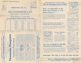
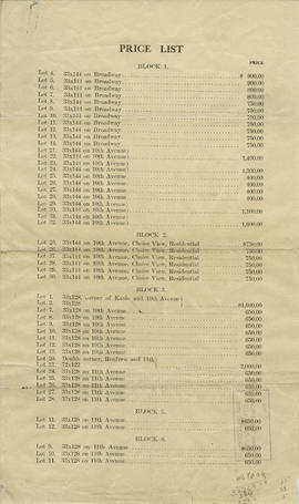
Municipality of Point Grey : sale of municipal-owned lands
Part of City of Vancouver Archives technical and cartographic drawing collection
Part contains text advertising properties in Point Grey and information on utilities, parks, schools, and property values in the municipality.
![Vancouver, B.C., the Pacific coast terminus of the C.P.R. [Canadian Pacific Railway]](/uploads/r/null/e/2/c/e2cdc004f3cf462100ed2ef053aa6087887b3f3200917cd5fba6292afb3b2d2d/bfcde3fa-32d7-4d08-86e5-ecf70c6f8388-LEG1340_142.jpg)
Vancouver, B.C., the Pacific coast terminus of the C.P.R. [Canadian Pacific Railway]
Part of City of Vancouver Archives technical and cartographic drawing collection
Part contains text and engravings describing Vancouver's climate, resources, industries, and buildings.

Map and views of the terminal city, Vancouver, British Columbia, Canada : inside map cover
Part of City of Vancouver Archives technical and cartographic drawing collection
Part is the inside cover of a fold-out map of Vancouver, and contains J.S. Matthews's conjectures regarding the date of the map's publication.

Map and views of the terminal city, Vancouver, British Columbia, Canada : map cover
Part of City of Vancouver Archives technical and cartographic drawing collection
Part is the cover for a fold-out map of Vancouver and contains advertisements for the East End Stationery Store.
Part of City of Vancouver Archives technical and cartographic drawing collection
Part contains promotional images of Vancouver including residences, Stanley Park, English Bay, and Hastings Street.
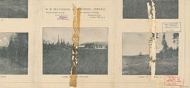
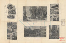
Map of West Vancouver and vicinity : verso
Part of City of Vancouver Archives technical and cartographic drawing collection
Part contains promotional images of West Vancouver and an advertisement for R.P. Matheson Advertising Service.

Street map of Greater Vancouver : map cover, street index and advertisements
Part of City of Vancouver Archives technical and cartographic drawing collection

What the man who comes to Vancouver wants to know
Part of City of Vancouver Archives technical and cartographic drawing collection
Part contains information on lodging, restaurants, transit, social clubs, and other points of interest in Vancouver.
Indexed guide map of the city of Vancouver and suburbs : map booklet back cover
Part of City of Vancouver Archives technical and cartographic drawing collection

Street index (Gibson Street to William Street) and tram stations
Part of City of Vancouver Archives technical and cartographic drawing collection
Part is a page from the booklet accompanying a guide map of Greater Vancouver, and contains the last portion of the North Vancouver street index, the West Vancouver street index, and a list of Vancouver tram stations.

Street index (Royal Oak Avenue, Vancouver to Frederick Road, North Vancouver)
Part of City of Vancouver Archives technical and cartographic drawing collection
Part contains two pages from the booklet accompanying a guide map of Greater Vancouver. Pages include the last portion of the Vancouver and Burnaby street index, the New Westminster street index, and the North Vancouver street index from 1st Street to Frederick Road.

Street index (Campbell Street to Rosser Avenue)
Part of City of Vancouver Archives technical and cartographic drawing collection
Part contains two pages from the booklet accompanying a guide map of Greater Vancouver.

District lot index and street index (1st Avenue to Campbell Avenue)
Part of City of Vancouver Archives technical and cartographic drawing collection
Part contains two pages from the booklet accompanying a guide map of Greater Vancouver.

Part of City of Vancouver Archives technical and cartographic drawing collection
Part is a page from the booklet accompanying a guide map of Greater Vancouver, and contains a list of hotels in Vancouver.

Indexed guide map of the city of Vancouver and suburbs : map booklet front cover
Part of City of Vancouver Archives technical and cartographic drawing collection

Part of City of Vancouver Archives technical and cartographic drawing collection

Information concerning the City and District of New Westminster and the Province of British Columbia
Part of City of Vancouver Archives technical and cartographic drawing collection
Part is the text side of a pamphlet. This part contains information concerning the city and district of New Westminster, with individual panels on the municipalities of Delta, Chilliwhack [sic], Surrey, Langley, and Delta, and the City of New Westminster, the town of Harrison Hot Springs and the province.

Vancouver airport. Design for Spanish Banks
Part of City of Vancouver Archives technical and cartographic drawing collection
Part is the front page of a brochure, showing cost estimates for various elements of the development.

Part of City of Vancouver Archives technical and cartographic drawing collection
Part is the front sheet of the unfolded pamphlet includes text on attractions, as well as photographs of the park, petting zoo, monuments, trails and gardens, and Malkin Bowl.
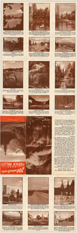
200 miracle miles through the Lower Fraser Valley
Part of City of Vancouver Archives technical and cartographic drawing collection
Part is one side of an unfolded tourism promotion brochure. The various panels depict photographs and give basic information on various sites mapped on the verso of the sheet.
British Columbia. Travel Bureau

Part of City of Vancouver Archives technical and cartographic drawing collection
Part is one side of a brochure for the Scenery Shop, displaying images , descriptions and prices of various souvenirs available.

A few facts about the north Fraser River
Part of City of Vancouver Archives technical and cartographic drawing collection
Part is a sheet of promtional-type information regarding economic activity in the municpalities bordering the north arm of the Fraser River. It lists nineteen companies operating along the north arm, with information on their capitalisation, turnover, profits, number of employees, etc.
Map and views of Vancouver, British Columbia, Canada
Part of City of Vancouver Archives technical and cartographic drawing collection
Part contains a street map of Vancouver from Vine Street to Garden Drive and Burrard Inlet to 16th Avenue, including an index of important municipal, civic and corporate buildings.