
- COV-S535-F4-: CVA 786-89.07
- Item
- 1978
Part of City of Vancouver fonds
3217 results with digital objects Show results with digital objects
Part of City of Vancouver fonds
Part of City of Vancouver fonds
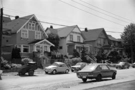
![[Maple Street at West 5th Avenue]](/uploads/r/null/e/8/c/e8cfa7575f61d95eedb0cbf4e68be9459b13afaaf82c23bd5215c2546ee0441b/ea6134dd-df60-463f-bd83-b30218a8fabc-CVA786-31_142.jpg)
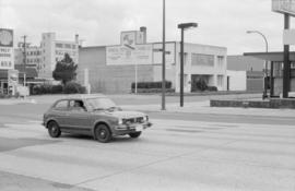
[Maple Street at West 5th Avenue]
Part of City of Vancouver fonds

Part of City of Vancouver Archives sound recording and moving image collection
Item is a documentary film documenting sports, wildlife, and tourist attractions in Stanley Park (B.C.). Film documents people cycling on the seawall by Coal Harbour, playing golf at the Stanley Park Pitch & Putt Golf course, playing tennis at an outdoor tennis court, and jogging beside Lost Lagoon. The film also contains footage of different birds at Lost Lagoon and around Stanley Park, including swans, geese, ducks, and seagulls. It also includes footage of cars driving along a road through the park, as well as the totem poles at Brockton Point with the Vancouver skyline in the background.

Intersection at Burrard St. and 3rd Ave.

Showing former mouth of Mackie Creek
Photograph shows parking lot and appartmant buildings near Heather Street and 6th Avenue, taken facing east north-east.

Showing former mouth of Mackie Creek
Photograph shows parking lot and apartmant buildings near Heather Street and 6th Avenue, taken facing east north-east.
Part of City of Vancouver fonds
Item is a photograph showing the Royal Bank.

Part of City of Vancouver fonds
Part of City of Vancouver fonds

Part of City of Vancouver fonds

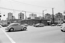
Bayswater St. between 5th and 6th Ave.s
Photograph taken facing north-west, towards property once owned by J. Z. Hall

Photograph shows Safeway store located at former site of Cedar Cottage Brewery at Kingsway and Knight Street. Photograph shows same site as shown in archives' photograph Dist. P.69 N.63

Part of City of Vancouver fonds
Part of City of Vancouver fonds

Part of City of Vancouver fonds

Part of City of Vancouver fonds
![Walks [2 of 3]](/uploads/r/null/1/e/1e83f91f6ef81f3820c37864fc9e84e53810be41cd4afe2e105d5e04254df8da/46a44585-1c9c-418e-8ae3-9e067cab679d-A64110_142.jpg)
Part of City of Vancouver fonds
Image shows street intersection at 5600 W. Boulevard.
Intersection at Burrard St. and 3rd Ave.

Intersection at Cambie St. and Broadway
Photograph taken facing north-west. Royal Bank building visible on right side of photograph
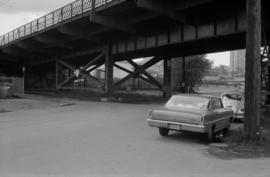
Lot beneath south side of Cambie St. Bridge
Photograph taken facing south-west.

Number 7 Cigarettes branded car
![[View of 600-block Granville Street]](/uploads/r/null/6/a/6a89448af40631b8c9fd1acdca9812bb3a01f928b3eb91d2957d505986ac422a/fbe94e97-57e2-4e5a-9d9a-96ab01a45c7f-CVA810-95_142.jpg)
[View of 600-block Granville Street]
![[View of 600-block Seymour Street]](/uploads/r/null/c/1/c13596e163625d14052955004244463df688fadf44cbca9ab1c04b4640b97b32/d2de1be2-08af-4d97-af19-dbbe729b3d71-CVA810-96_142.jpg)
[View of 600-block Seymour Street]
![[View of three houses on Jackson Avenue from the corner of Oppenheimer Park]](/uploads/r/null/5/c/5c8e73d135383cf949fa54a967ceca3bb4897c7513855bf7d95669bbd58b37dc/41c5b4a9-98b2-4d74-8629-9930de792ecc-A59207_142.jpg)
[View of three houses on Jackson Avenue from the corner of Oppenheimer Park]
Part of City of Vancouver fonds
![[View of 900 block Seymour Street]](/uploads/r/null/8/a/8a5b02b2c474bf4b469da2d909bb54224b911318574331cce7bc62d4574553c8/7f06889b-efed-40ae-b34c-c6615fa12dd1-CVA810-93_142.jpg)
[View of 900 block Seymour Street]
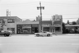
Sign for Dominion Motors can be seen.

CKNW Orphan Fund promotional vehicle and station on grounds
600 [Block] West Granville - Seymour [Commercial real estate survey Downtown Vancouver]
File includes images of commercial real estate properties in Downtown Vancouver, B.C.
The reverse of some photographs contain information relating to the type of commercial property, rental and lease figures and recent sales information for each property.
CVA 810-93: [View of 600-block Seymour Street]
CVA 810-94: [View of 600-block Granville Street]
CVA 810-95: [View of 600-block Granville Street]
CVA 810-96: [View of 600-block Seymour Street]
![[View of 600-block Granville Street]](/uploads/r/null/8/9/8910c5570c50593391d7e3554258b3f3f7df7d69223719124eedd8ccf4570923/21f2fac3-909e-49d8-868e-b6c3a0f3334b-CVA810-94_142.jpg)
[View of 600-block Granville Street]
Downtown Theatre can be seen.
![Abbott and Cordova [Streets looking] north](/uploads/r/null/8/a/8aab879fc7571cea390137d122ac3a89381071b678502757448c72f1fa930e4f/7cda2f7c-4836-4e9a-bb47-04f727a330f0-A42710_142.jpg)
Abbott and Cordova [Streets looking] north
Part of City of Vancouver fonds
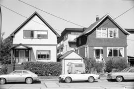
![Alder [Street] and 6th [Avenue looking] west](/uploads/r/null/9/c/9c3510984925b6c73b0f03fe9efc1a5f0c4f319bc1012d03aa9caa3e5b60cb47/373b8340-f09c-4f8c-b47d-a21aa18ae822-A42723_142.jpg)
Alder [Street] and 6th [Avenue looking] west
Part of City of Vancouver fonds
![Alma [Street]and Broadway [looking] south](/uploads/r/null/4/d/4dafffe711c2871a06198b0ffd371738a92f41b9a756e865cf32b41bb712a733/f1a34532-ad4a-4a7f-a67d-e800c9132525-A42726_142.jpg)
Alma [Street]and Broadway [looking] south
Part of City of Vancouver fonds
![Alma [Street] and Broadway [looking] north](/uploads/r/null/f/e/fe19941ed63249d77fd1b5a19cf8c68f6469fc9a1fa766c7170f69506850e2d1/d27e2826-b62d-4fd1-aac2-de85149a4ae5-A42728_142.jpg)
Alma [Street] and Broadway [looking] north
Part of City of Vancouver fonds
![Oak [Street] and 12th [Avenue looking] north](/uploads/r/null/e/7/e716819cc94a5e03baff80d4bd7010d2d565ab4cf7f41b49c52ab9b32b1afb86/596b5506-7b75-496e-9e87-2ad483b10197-A44168_142.jpg)
Oak [Street] and 12th [Avenue looking] north
Part of City of Vancouver fonds
![Alma [Street] and 4th [Avenue looking] north](/uploads/r/null/a/5/a50d988adfd3b22b6c365431eb3726d4e3eb73628b853daab3b875bb3f6700a3/ff9d2cba-84bd-435b-92bd-deabeb9c49d6-A42730_142.jpg)
Alma [Street] and 4th [Avenue looking] north
Part of City of Vancouver fonds
![Balsam [Street] and 4th [Avenue looking] west](/uploads/r/null/6/f/6fa41a1a955cf9ef742c29788264365bc80f4c9f1c7669c652777473271a2ae1/fe03600e-a251-458a-bdc7-a7272c1149a5-A42768_142.jpg)
Balsam [Street] and 4th [Avenue looking] west
Part of City of Vancouver fonds
![Beatty and Dunsmuir [Streets looking] west](/uploads/r/null/a/5/a5cc70fc63b687b855560327354898a98485aa1722ce5ed472b0f5e04ddb980d/5f3cede3-6490-40ec-b097-77b4de2855bc-A42774_142.jpg)
Beatty and Dunsmuir [Streets looking] west
Part of City of Vancouver fonds
Photograph shows the Sun Tower in the background
![Beatty and Georgia [streets looking] north](/uploads/r/null/3/1/31215f49fea2b0a3182e4a22b043fa56460d30315d5b5a37cd5c1a18f7900c25/1d47aeac-0b19-4088-ab9d-705c282128c7-A42779_142.jpg)
Beatty and Georgia [streets looking] north
Part of City of Vancouver fonds
Photograph shows the Sun Tower in the background
![East Boulevard and 41st [Avenue looking] east](/uploads/r/null/6/9/6941d49e3b4f1c25de448e33222e7f5d133cf29fe27d914ba7fc43d7e72dde6b/af0b6677-dae7-44d2-a0ef-462a64f3f217-A42816_142.jpg)
East Boulevard and 41st [Avenue looking] east
Part of City of Vancouver fonds
![Boundary [Road] and Canada Way [looking] north](/uploads/r/null/c/9/c90db28f3b678971741c4dc2e61fd545d79390007e677288d864343864f68dff/9606c6e2-a8a0-4d76-bba7-64f780693e45-A42840_142.jpg)
Boundary [Road] and Canada Way [looking] north
Part of City of Vancouver fonds
![Boundary [Road] and 49th Avenue](/uploads/r/null/5/a/5a35fb9b5adde23b3e3087ed16e90ad28b1692f8910a344f24a71f03ffeb2914/8f2d6851-20bf-4530-a2aa-def3180c04fb-A42895_142.jpg)
Boundary [Road] and 49th Avenue
Part of City of Vancouver fonds
![Burrard [Street] and Davie [Street looking] west](/uploads/r/null/f/c/fc6693c48ae2a6eb0f5f3d6de208bc2405b8b37d98daec1f5bf01f3e21c0895b/5e6c9eb2-0243-45fb-b819-ba0e09964133-A42914_142.jpg)
Burrard [Street] and Davie [Street looking] west
Part of City of Vancouver fonds
![Burrard [Street] and Davie [Street looking] east](/uploads/r/null/4/5/452d48b4b8fd2d946861524d78b0afec674820ddfb66bd58b76208199b8eaa56/1a3b374f-a779-4587-8579-f7ed481ab190-A42916_142.jpg)
Burrard [Street] and Davie [Street looking] east
Part of City of Vancouver fonds
![Burrard [Street] and Georgia [Street looking] south](/uploads/r/null/8/8/88730712cb8ee8f10d03c14e9ac6ec9dfead7ef25eedfd0bc0a279908f4f7d40/f3bc63dd-4b85-4667-bd59-5c1e9169dceb-A42925_142.jpg)
Burrard [Street] and Georgia [Street looking] south
Part of City of Vancouver fonds
Photograph shows part of the Hotel Vancouver
![Burrard [Street] and Pacific [Street looking] north](/uploads/r/null/0/e/0ee2c5345075df7bf1eb0634968badfe20cdce1f728bd55dc6543551e3bb69ca/2086cdbb-c37d-4734-abc6-6fcdb0301f7d-A42939_142.jpg)
Burrard [Street] and Pacific [Street looking] north
Part of City of Vancouver fonds
![Burrard [Street] and Robson [Street looking] east](/uploads/r/null/b/8/b8472305bb21f414561ea69cab7ac471c64d18a1f04771b1e136a16b6786bd4f/9e6374b2-c939-4f38-bb0a-b0cefec39e9c-A42949_142.jpg)
Burrard [Street] and Robson [Street looking] east
Part of City of Vancouver fonds
![Burrard [Street] and Robson [Street looking] west](/uploads/r/null/7/c/7cd567f8c991ffec5b746d87b17d0b29e980dea7e3d21caf6cbac4daf29b074e/cf1c88bd-092f-4ee8-9419-67469abc1b0c-A42951_142.jpg)
Burrard [Street] and Robson [Street looking] west
Part of City of Vancouver fonds
![Burrard [Street] and 4th [Avenue looking] west](/uploads/r/null/5/f/5fd1fe104b95981cdc86898f4d2564d557c8cac725c7163ec04d6799065fa1e9/d694f7d9-63f7-45ca-b59c-939260930582-A42956_142.jpg)
Burrard [Street] and 4th [Avenue looking] west
Part of City of Vancouver fonds
![Bute and Robson [Streets looking] east](/uploads/r/null/e/6/e69b794e691000d59e2ff31a559c6cd4075bc1b126ea3288bc4fe00a73d22e54/28d25222-d59c-4dfd-a4f5-ced8d1eb95f4-A42858_142.jpg)
Bute and Robson [Streets looking] east
Part of City of Vancouver fonds
![Cambie and Broadway [streets looking] west](/uploads/r/null/3/0/30b6fe787906ad93d772096eb6b71e164e4ef4894c29306eb8a483e83d2a83a7/0e7cb8a0-e71d-43f1-8c1a-90f7a11553db-A42979_142.jpg)
Cambie and Broadway [streets looking] west
Part of City of Vancouver fonds