
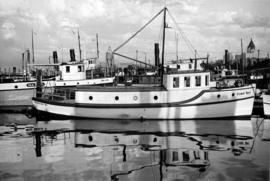
- AM1668-: CVA 293-022
- Item
- Nov. 26, 1975
462 results with digital objects Show results with digital objects

View of Fisherman's Cove taken from highway to Horseshoe Bay
Part of Vancouver Express fonds
Vancouver skyline from Coal Harbour [Boats docked in marina: "Cohoe Bay" and "Sal Lal"]
Part of Karl Haspel fonds

Rail journey through the Rocky Mountains, Victoria, and dog show
Part of Samuel S. Magoffin fonds
Item is an amateur film opening with footage of downtown Vancouver showing several Vancouver Fire Department trucks and engines and a lot filled with lumber, then cutting to footage taken from the back of a moving train, showing snow covered scenery, followed by Sam and Margaret Magoffin standing on a porch with several other people and a dog, Margaret and a man standing in front of a car, and additional footage taken from a moving train showing a sign for Yoho, mountain scenery and the Cathedral train station. The film also contains footage taken in downtown Victoria, B.C. showing the legislative building, Inner Harbour and CPR Steamship Terminal building, followed by dogs, likely the Magoffin’s golden retrievers, and several minutes footage of a dog show.
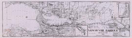
Vancouver Harbour [sectional map]
Part of City of Vancouver Archives technical and cartographic drawing collection
File contains 42 maps showing soundings, harbour headlines, high water marks, shore lines, shoals, submarine cable, rail lines and trails in the Vancouver area. Maps also show names of businesses and other structures.
Vancouver Harbour : plan of south shore, Burrard Inlet between Heatley Ave. and Victoria Dr.
Part of City of Vancouver Archives technical and cartographic drawing collection
Item is a map which shows parcels of land along Burrard Inlet and district lots in downtown Vancouver. Piers, factories and mills along the waterfront are identified. Soundings are shown in feet.
Vancouver Harbour, British Columbia
Part of City of Vancouver Archives technical and cartographic drawing collection
Item is a nautical chart of Burrard Inlet, including the southern portions of the North Arm of Burrard Inlet. The map shows depth soundings, harbour anchorages, headlines, beacons, buoys, bells, piers and wharves. The map also shows lot numbers, municipal boundaries and major street names of the southern portion of North Vancouver and the northern portions of Point Grey, Kitsilano, Mt. Pleasant, Fairview, Hastings Townsite, Burnaby and Port Moody from the Coquitlam municipal boundary in the east to the western boundary of the Vancouver harbour (between Point Atkinson and Point Grey) in the west. The item also includes a key map showing the location of the Vancouver Harbour in relation to northwestern Washington and Vancouver Island and an inset map showing lots surrounding the north arm of Burrard Inlet to the Inlailawatash Indian Reserve.

False Creek interim harbour headline
Part of City of Vancouver Archives technical and cartographic drawing collection
Map shows interim and ultimate headline, interim headline, ultimate headline, and existing headline, as well as streets, lots, railway yards and waterfront industries in the False Creek area. Map was created for the "False Creek development" study, "Harbour headline" project.

Part of City of Vancouver Archives technical and cartographic drawing collection
Item contains both nautical chart and map data. Nautical chart data includes soundings, anchorages, ferry lines, wharves, and waterfront businesses. Map features include district lots, streets, railways, and municipal boundaries.

Port of the City of Vancouver. Isometric view from the south-west
Part of City of Vancouver Archives technical and cartographic drawing collection
Item is a set of maps printed on one sheet. The main map shows an isometric view of the port of Vancouver from Stanley Park through the Second Narrows Bridge (including North Vancouver). The perspective point appears to be located above the Granviile Street and West Georgia Street intersection. Note that the isometric view of locations west of Granville Street is from the south-east, rather than the south-west, as indicated in the title.
The map depicts the port infrastructure, including piers, drydocks and companies located in the port.
The inset maps are a key plan showing the location of the port relative to the Lower Mainland as a whole, and a larger-scale map entitled "Plan of the Port of the City of Vancouver from Coal Harbour to Second Narrows". It contains more detail about the names of the various piers, drydocks and companies and shows the North Vancouver port facilities as well as south shore ones.

Map of the harbour of New Westminster, British Columbia
Part of City of Vancouver Archives technical and cartographic drawing collection
Item is a map showing the Fraser River and its North Arm as well as the Westminster Waterway surrounding New Westminster. A key map shows the location of New Westminster in relation to the Greater Vancouver area.
Vancouver Harbour : plan of south shore, Burrard Inlet between Heatley Ave. and Victoria Dr.
Part of City of Vancouver Archives technical and cartographic drawing collection
Item is a map which shows parcels of land along Burrard Inlet and district lots in downtown Vancouver. Piers, factories and mills along the waterfront are identified. Soundings are shown in feet.
National Harbours Board
![Granville [Townsite], B.C. Aug., 1885](/uploads/r/null/1/a/4/1a45ddd637fe3f3726748d5096017a8461446b9a013c408ed2b1666c8433e1f9/405fdc0d-6d88-41b7-937f-36cc7f51518a-MAP553_142.jpg)
Granville [Townsite], B.C. Aug., 1885
Part of City of Vancouver Archives technical and cartographic drawing collection
Item is a fire insurance map of the "Coal Harbour" [south shore of Burrard Inlet] area. The Hastings Saw Mill Company and Coal Harbour Fishery are shown in detail. Other businesses along Front Street are identified including hotels and stores.
Part of City of Vancouver Archives technical and cartographic drawing collection
Item is a map showing dredging of Coal Harbour, with depth soundings given in feet (taken from Admiralty charts). The map hows which areas of land in Coal Harbour were dry at low water levels.
Canada. Department of Public Works

First Narrows, Burrard Inlet, B.C. showing Parthia and Burnaby shoals
Part of City of Vancouver Archives technical and cartographic drawing collection
Item is a map showing shorelines, estuaries of adjacent creeks, mud flats, tide levels and soundings in feet. Map notes velocity of current at First Narrows.
New Westminster (B.C.). Department of Public Works

Part of City of Vancouver Archives technical and cartographic drawing collection
Item is a sheet with three nautical charts. The main chart depicts Burrard Inlet from Atkinson Point [Point Atkinson] in the west to the "townsite of Port Moody" in the east. The inset charts depict Vancouver Harbour and the Second Narrows.

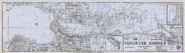
Vancouver Harbour. British Columbia
Part of City of Vancouver Archives technical and cartographic drawing collection
Item is a map sheet containing three nautical charts. The main map shows English Bay and Burrard Inlet and the land bordering these bodies of water, including North and West Vancouver, Downtown Vancouver, the University Endowment Lands and Port Moody. Inset maps depict the north arm of Burrard Inlet and a chart showing Vancouver Island in relation to the B.C. coast and the state of Washington, U.S.A.

Vancouver Harbour : Sheet 3 (Second Narrows to Port Moody)
Part of City of Vancouver Archives technical and cartographic drawing collection
Item is a nautical chart of Vancouver Harbour from Second Narrows in the west to Port Moody in the east, showing soundings in fathoms, tidal information, anchorages, beacons, and waterfront businesses. Street names are shown on land areas.

Vancouver Harbour : Sheet 2 (Point Grey to Second Narrows)
Part of City of Vancouver Archives technical and cartographic drawing collection
item is a nautical chart of Burrard Inlet and Vancouver Harbour from Point Grey in the west to Second Narrows in the east, showing soundings in fathoms, tidal information, anchorages, beacons, and waterfront businesses. Street names are shown on land areas. A Royal Canadian Air Force bombing range at Jericho Beach is identified as a danger area.

Vancouver Harbour : Sheet 1 (First Narrows to Second Narrows)
Part of City of Vancouver Archives technical and cartographic drawing collection
Item is a nautical chart of Vancouver Harbour from First Narrows in the west to Second Narrows in the east, showing soundings in fathoms, tidal information, anchorages, beacons, and waterfront businesses. Street names are shown on land areas.
Part of City of Vancouver Archives technical and cartographic drawing collection
Item is a brochure promoting tourism along the British Columbia coast using Union Steamships routes. The unfolded brochure has text and illustrations on one side and on the other text with a map showing the routes to destinations described in the brochure.
Vancouver Harbour, British Columbia, 1964
Part of City of Vancouver Archives technical and cartographic drawing collection
Item is a nautical chart showing English Bay and Burrard Inlet with soundings in feet, anchorages, locations of submarine cables, and ferry lines. Land features include city blocks and district lot numbers. Includes inset maps of the North Arm of Burrard Inlet and Vancouver Island.

Vancouver Harbour, British Columbia, 1932
Part of City of Vancouver Archives technical and cartographic drawing collection
Item is a nautical chart showing English Bay and Burrard Inlet with soundings in feet, anchorages, locations of submarine cables, and ferry lines. Land features include city blocks and district lot numbers. Includes inset maps of the North Arm of Burrard Inlet and Vancouver Island.
The Port of Vancouver : Canada's key city of the West
Part of City of Vancouver Archives technical and cartographic drawing collection
Item is a brochure promoting Vancouver harbour as a hub of economic activity in the city. The brochure includes illustrations of harbour activity, facts about various aspects of the operations to show the harbour's capacity and facilities.
Vancouver Harbour, British Columbia, 1945
Part of City of Vancouver Archives technical and cartographic drawing collection
Item is a nautical chart showing English Bay and Burrard Inlet with soundings in feet, anchorages, locations of submarine cables, and ferry lines. Land features include city blocks and district lot numbers. Includes inset maps of the North Arm of Burrard Inlet and Vancouver Island. Note at the bottom of map states, "Not to be used for navigational purposes."
Vancouver, British Columbia. Souvenir from the lion gateway
Part of City of Vancouver Archives technical and cartographic drawing collection
Item is a promotional brochure for the City of Vancouver, included as a holiday supplement in the Vancouver Daily and Weekly World newspapers. The brochure was designed to be folded.
Tidal current charts : Vancouver Harbour, British Columbia
Part of City of Vancouver Archives technical and cartographic drawing collection
Item is a booklet containing twelve charts showing tidal currents in Vancouver Harbour at different points in the tidal cycle.

Plan of the City of Vancouver, B.C.
Part of City of Vancouver Archives technical and cartographic drawing collection
Item is a map of the old City of Vancouver south to 16th Avenue. The map depicts District Lots and blocks, railway lines, street car lines, industrial areas, parks, postal information, schools, property boundaries.
Plan of False Creek, Vancouver, B.C.
Part of City of Vancouver Archives technical and cartographic drawing collection
Map shows streets, railways, land to be reclaimed, foreshore applied for, foreshore granted by order in council, proposed wharf lines, areas to be dredged and land ownership in and along False Creek. A key map in the top right-hand corner shows the location of False Creek in relation to the rest of Vancouver.

Part of City of Vancouver Archives technical and cartographic drawing collection
Item is a map showing major landmarks, railway lines, harbour lands reclaimed, proposed wharves and piers, retaining walls and dredging, and soundings in fathoms in Vancouver Harbour (Burrard Inlet) and False Creek.

Part of James Luke Quiney fonds
![N.P.A.A.O. [North Pacific Association of Amateur Oarsmen. One-man scull at] Esquimalt](/uploads/r/null/2/c/7/2c7a041f4573b48dfe710ad66ac640d7e95a4566083535aa2ed127c5268a1b18/931a73ba-3eb4-4564-9a85-04a72e883331-CVA7-318_142.jpg)
N.P.A.A.O. [North Pacific Association of Amateur Oarsmen. One-man scull at] Esquimalt
Part of James Luke Quiney fonds
![N.P.A.A.O. [North Pacific Association of Amateur Oarsmen. Four-man sculls at] Esquimalt](/uploads/r/null/3/9/9/39987f37873391a1c3f2c8d1a3117b3b780fd35f99916cea9c357f5094bb1227/15ea02ff-5b9a-4e86-9d07-ac6d7e360763-CVA7-317_142.jpg)
N.P.A.A.O. [North Pacific Association of Amateur Oarsmen. Four-man sculls at] Esquimalt
Part of James Luke Quiney fonds
![[South side of Coal Harbour at low tide with four-man scull]](/uploads/r/null/5/d/5d701a946729d7f820e43fd05966163d0f63a80eebee16e404fb12ca24cb73f7/1d70962a-414f-40fe-8b16-3cfc609c2393-A20515_142.jpg)
[South side of Coal Harbour at low tide with four-man scull]
Part of James Luke Quiney fonds
Harbour during the Blushes Beautiful Ski to Sea Relay Race
![Harbour panorama [with] war canoe](/uploads/r/null/1/3/5/13571c1c3dc1e530a1e923e7264be75706d8af95af9a588dcf00ff1206d334c5/cd1f3b56-7afa-4c5c-ac2a-92ed07ed331a-2011-010_142.jpg)
Harbour panorama [with] war canoe


Granville, B.C. 1885 - C.P.R. plan

'Greenhill Park' ship explosion in Vancouver Harbour

Princess Elaine enters Vancouver Harbour on maiden voyage to join the C.P.R. Princess fleet

The rum-runner 'Trucilla' enters Vancouver Harbour
![Vancouver harbour from the roof garden [of David] Spencer's [Department] Store](/uploads/r/null/d/b/db5a883c9aac8bed679b57c2205d549efa86b2a28446fb64721146f1befa6a70/d5e169c6-2878-4aa0-ae91-fea056b71eac-CVA258-8_142.jpg)
Vancouver harbour from the roof garden [of David] Spencer's [Department] Store
Part of Hubert William Lovell fonds
Pier D, Empress of Russia, Deadman's Island and Brockton Point are visible in the distance. Photograph was taken in the summer.

Part of Hubert William Lovell fonds
Photograph was taken in the summer.

Eagle Harbour, old logging buildings
Part of Hubert William Lovell fonds
Photograph was taken in the summer.

Part of Hubert William Lovell fonds
Photograph was taken in the summer.

Part of Yaletown Productions Inc. fonds
This item consists of raw footage featuring B.C./Expo 86 aerials; shot in 35mm and transferred to one inch tape. Original negative no longer exists and only video footage survives. Some of this material was used in Yaletown Production's video postcard series. There are several shots of the B.C. Pavillion, now the Telus World of Science; including nighttime shots of the B.C. Pavillion, the Expo grounds and the city. Some scenes have been sped up.

Part of Yaletown Productions Inc. fonds
This item consists of raw footage featuring B.C./Expo 86 aerials; shot in 35mm and transferred to one inch tape. Original negative no longer exists and only video footage survives. Some of this material was used in Yaletown Production's video postcard series. Includes nighttime footage of downtown Vancouver.
![BC [British Columbia] postcard - The Rockies to the Pacific [Japanese version]](/uploads/r/null/1/2/1226943/1fe338ae-0558-47de-bc78-ac3a556700b9-MI-343_142.jpg)
BC [British Columbia] postcard - The Rockies to the Pacific [Japanese version]
Part of Yaletown Productions Inc. fonds
Film is a promotional video for the province of British Columbia this version has Japanese narration. Focusing on different sections of the province in turn the video highlights the features and tourist attractions of each. According to the donor this is most likely the original of the final production with sound and image. Director Mike [Michael] Collier; cinematography Norm Keziere, Dave Geddes, Bob Asgeirsson, Bill Rounds, Tommy Tompkins, and John Anderson; editor Rober Brandreth-Gibbs; research Sharon McGowan; narration script Don White and Sharon McGowan, narrator Art Hives; video services Post Haste Video; film lab Alpha Cine Services; sound mix Pinewood Studios; special thanks to Tourism British Columbia. Produced by Yaletown Productions. Ends with an advertisement for 'Canada's Best Selling Video Postcard Series.' b&w 00:10:57-00:11:04 and 00:18:47-00:19:22.
![BC [British Columbia] postcard - The Rockies to the Pacific](/uploads/r/null/1/2/1226936/e2a6b4cf-7e7e-48c3-8e3b-6a150d917129-MI-342_142.jpg)
BC [British Columbia] postcard - The Rockies to the Pacific
Part of Yaletown Productions Inc. fonds
Film is a promotional video for the province of British Columbia. Focusing on different sections of the province in turn the video highlights the features and tourist attractions of each. According to the donor this is most likely the original of the final production with sound and image. Director Mike [Michael] Collier; cinematography Norm Keziere, Dave Geddes, Bob Asgeirsson, Bill Rounds, Tommy Tompkins, and John Anderson; editor Rober Brandreth-Gibbs; research Sharon McGowan; narration script Don White and Sharon McGowan, narrator Art Hives; video services Post Haste Video; film lab Alpha Cine Services; sound mix Pinewood Studios; special thanks to Tourism British Columbia. Produced by Yaletown Productions. b&w 00:10:57-00:11:04 and 00:18:47-00:19:22.