
Mimulus on cliffs, Pacific Rim
- AM1502-S1-1-: CVA 1502-3865
- Item
- June 1973
569 results with digital objects Show results with digital objects
Mimulus on cliffs, Pacific Rim
![Miscellaneous [100 of 130]](/uploads/r/null/9/6/96c1c4dd25b6c7ba6a6479652806ad75cfe399d921c9b767bb0a128fdf932a6d/8abff136-b7ad-47bd-b4f5-0ee521b9b288-A67532_142.jpg)
Part of City of Vancouver fonds
![Miscellaneous [102 of 130]](/uploads/r/null/c/2/c2f4499f0e77383c330e21ed2f341200fa771698e5a42ef58229230e3ffa00ef/28190a65-a694-431a-b5a9-90d2046a600f-A67534_142.jpg)
Part of City of Vancouver fonds
![Miscellaneous [118 of 130]](/uploads/r/null/5/7/57403a1f4476c4a743cde572f646f29ae76d74f0efe6c90a7b2b5c5a33013fd9/3849ebe1-cc8a-4342-826c-f8c2a4387bd5-A67550_142.jpg)
Part of City of Vancouver fonds
Item is a photograph showing Coal Harbour with the Shell marine fuel dock in the foreground and a cruise ship, a float plane and downtown buildings in the background.
![Mission Village, No[rth] Vancouver, B.C.](/uploads/r/null/f/d/fd6544b0fa5523eba07e4822e410b37e864fefd55b7ecb295d2dfd2b32393643/bcde4eee-fada-4190-8186-bfee41038417-A03957_142.jpg)
Mission Village, No[rth] Vancouver, B.C.
Part of Major Matthews collection
Photograph shows church, houses, and boats along the shore.

Mount Gardner Park, Bowen Island, B.C.
![[M.S. "Lochkatrine" at dock]](/uploads/r/null/0/a/0aef252af15e3a76e09a6394c8b5cff52d041c70b0e64f500f0944f98991230c/d6844f43-9a6a-4f3b-8dfe-8c53e0075c91-A29728_142.jpg)
Part of Walter E. Frost fonds

My up-country trip : Kelowna waterfront
Part of William Orson Banfield fonds

My up-country trip : The boat arriving at Kelowna
Part of William Orson Banfield fonds

Part of Major Matthews collection
Photograph shows the Hudson Bay Company's bastion

Photograph shows a view of New Westminster from across the Fraser River

Photograph shows docks and boats, commercial and industrial buildings, and houses in the distance.
![New Westminster, B.C. [from the water]](/uploads/r/null/7/8/78e19dc8b4734b1ad937df43a4f0c3498389c306ac0fa1b93afe49762af47ca5/03a55f73-18bd-4699-baa1-c01c8eac544b-A71343_142.jpg)
New Westminster, B.C. [from the water]

New Westminster, B.C. from the waterfront
Photograph shows three men in a boat ("The Canco") in the Fraser River near the New Westminster waterfront.
![New Westminster, B.C. [waterfront area]](/uploads/r/null/3/9/393d0003bd15e184863d0d02d03ffec195e8ac1a4bc8183377847359882b61ca/ec6cf2d6-ec41-40d7-9eda-eec2a58294a1-A02608_142.jpg)
New Westminster, B.C. [waterfront area]
Photograph shows the waterfront area from across the Fraser River. Photograph shows industrial buildings, houses, and some streets.

New Westminster, British Columbia
Part of Major Matthews collection
Photograph shows Royal Columbian Hospital, Irving House and St. Andrew's Presbyterian Church.
Nine O'clock Gun, Stanley Park
Part of City of Vancouver fonds
item show the Nine O'clock Gun and plaque in Stanley Park, Vancouver.
![North Portal Dunsmuir Tunnel [1 of 3]](/uploads/r/null/1/f/1f999736dc5ea4b22b4133cda60c20ab5cce87cc251dde7c9f555ddc4d071e22/67a18b7e-4a68-44b4-b5a5-33fd3496df6b-A66675_142.jpg)
North Portal Dunsmuir Tunnel [1 of 3]
Part of City of Vancouver fonds
![North Portal Dunsmuir Tunnel [2 of 3]](/uploads/r/null/e/1/e138164f03396140e2d98b50c56affbb9d7d7121bb6b0851ba5dbbd57ee61613/82cadf77-9465-4b61-a68e-59202620e921-A66676_142.jpg)
North Portal Dunsmuir Tunnel [2 of 3]
Part of City of Vancouver fonds
![North Portal Dunsmuir Tunnel [3 of 3]](/uploads/r/null/6/d/6d5a82659d6b11e2e3a1456df7e738100bc56b3439a62918e1e4b0c7eb5ed926/43d3d188-0aa7-48a8-8e0e-58f8f9828964-A66677_142.jpg)
North Portal Dunsmuir Tunnel [3 of 3]
Part of City of Vancouver fonds
![[North Vancouver from Burrard Inlet]](/uploads/r/null/f/2/f285dd5633144f255b287145d9cec78b096827c3110720acace67fe73e7d654a/b97f757f-39e2-4c8f-9352-a095c360e4fe-A02535_142.jpg)
[North Vancouver from Burrard Inlet]
Photograph shows roads, houses, and other buildings near the North Vancouver waterfront.
![North Vancouver from float [at] foot of Lonsdale Avenue](/uploads/r/null/4/b/4bd277a4acc375f4c76ebbc03764f9e519a72bc4dda0b25c133ce93f057032df/20929a6c-70bf-4dd4-966b-59bffc19f17d-A26830_142.jpg)
North Vancouver from float [at] foot of Lonsdale Avenue
Part of Major Matthews collection
Photograph shows the residences of William Bridge and Charles Mee and the Larson Hotel

Part of Stuart Thomson fonds
Oblique view showing Burrard Dry Dock and Lonsdale Avenue

![Old Granville Bridge [being demolished]](/uploads/r/null/a/c/acad946ba127693849963e9a8d02ea3fa1bd3356e372885756474042193b0202/5ce65475-ac21-4c3f-9280-715aab4fdc06-A21670_142.jpg)
Old Granville Bridge [being demolished]
Part of Walter E. Frost fonds
Photograph shows Granville Island, Watkins-Winram Ltd., Spear and Jackson Ltd., Tyee Machinery Co. Ltd., and part of the new Granville Bridge.
![Pacific Mills [village and mill on the] Queen Charlotte Islands](/uploads/r/null/8/3/83316ff3273cbada7669358e7fd19ca3844e68643557a070188e2ed269fe8f74/25b4fa4e-52d0-45db-9cb2-5f4d33ebd66d-A14900_142.jpg)
Pacific Mills [village and mill on the] Queen Charlotte Islands
![[Panoramic view of] Dawson City Y.T. [and surrounding area during the gold rush]](/uploads/r/null/5/0/506e42684abd11564a15b6ed320519f1fdfe76b93282f62a101c43cb73368b4c/aef0d3ce-b0eb-45e2-8d0a-f639840ce71b-A64736_142.jpg)
[Panoramic view of] Dawson City Y.T. [and surrounding area during the gold rush]
Part of Major Matthews collection
![[Panoramic view of Vancouver Harbour from Stanley Park]](/uploads/r/null/0/5/05ba7ee07d565760f128d08c4e45dbc2251d1683598332143dee30a54daa704d/6784e896-7064-41ba-98a5-fa5718080c47-A31797_142.jpg)
[Panoramic view of Vancouver Harbour from Stanley Park]
Part of Major Matthews collection
Prominent buildings identified are Hotel Vancouver (900 West Georgia), the Georgia Medical Dental Building, Immigration Building, Marine Building, Royal Bank and Pier "BC". Ships identified are (L-R): "Catala", "Princess Louise", "Robert Merrick", "Empress of Japan", "Aorangi", C.P.R. transfer car barage, "Kyuqust" and Union Oil Co. Tanker.
![[Panoramic view of waterfront at Gibsons]](/uploads/r/null/2/e/2e31713a561ead576964cc3e23993fb78f15fd911ff21fa225138ba222950405/d12c1cd2-9da3-48df-b9e9-94527c3b4ec6-A31840_142.jpg)
[Panoramic view of waterfront at Gibsons]
Part of Major Matthews collection
![[Panoramic view of waterfront at Gibsons]](/uploads/r/null/0/1/01638011db11a1cd6b3d6970c9d00c13802fca7e9c6201524e92bd8fb88d2f66/1f926b12-68e1-413c-9715-5fca8c6da542-A31841_142.jpg)
[Panoramic view of waterfront at Gibsons]
Part of Major Matthews collection

Part of Vancouver, B.C. from Harbor
Part of Major Matthews collection
Photograph shows a yacht race, part of Spratt's Ark and the City Wharf crowded with spectators in the background
![[Partially cleared area around ]Vancouver Harbor](/uploads/r/null/e/1/e12fdee1e0eba10ba7b4a75a7def726e3041140dfedc735e0cfd5b986d4c8e7a/8704f285-a921-43d4-9142-67a3f6d1e034-A04060_142.jpg)
[Partially cleared area around ]Vancouver Harbor
Part of Major Matthews collection
J.S. Matthews' notes with print or negative in Archives.
![[Partially constructed power house for Buntzen Lake Power Plant number one]](/uploads/r/null/6/0/60e0611466e592b1ea94f1f9b543eeb7ed42b3e11c115dab467393cbdbc6cac4/523e083c-e0d3-4669-9051-bf5119a6bf72-A04738_142.jpg)
[Partially constructed power house for Buntzen Lake Power Plant number one]
Part of Major Matthews collection
![Pender Harbour [Pender Island?]](/uploads/r/null/6/3/b/63b629a5813379cb3640aea0da51218da4a317a0931977a474787fde2fe731d4/7a952432-a23f-422d-80eb-3f21b6e3e32a-CVA440-29_142.jpg)
Pender Harbour [Pender Island?]
![Penticton B.C. [from the water]](/uploads/r/null/f/7/f70034577cf3cdff345690dfe3b93cffda9c71c7299b6ee7ec7460d16a70d330/0ca3b1ea-12e0-46a6-9308-624068c17360-A50179_142.jpg)
Penticton B.C. [from the water]
Part of John Davidson fonds
Photograph shows a C.P.R. railway car barge

People standing on unidentified pier
Part of John Davidson fonds


People walking down Port Hardy pier
![Pier B.C. [1 of 2]](/uploads/r/null/c/2/c2a13bb68bacbd5044f4854164529f13b8dbb4f38424e4aa702d5ae2c459fc90/b71f69b1-1634-44bc-8ef2-9a5870b2a637-A66654_142.jpg)
Part of City of Vancouver fonds
Image shows construction of Pier B.C.
![Pier B.C. [2 of 2]](/uploads/r/null/6/8/68bd2e3ef667db3d56c78d20873479e17c26068b61c7ed1bc74cf3f7e0378343/cd331488-06f1-4e44-8a48-19406e700c14-A66655_142.jpg)
Part of City of Vancouver fonds
Image shows construction of Pier B.C.

Part of William McNeill fonds
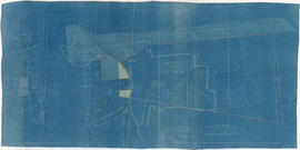
Item is a survey plan showing the layout of buildings on a section of reclaimed land where Carrall Street meets False Creek, and property ownership in adjacent areas. An index plan shows the location covered by the main map in relation to the surrounding area.

Plan showing foreshore applied for by the British Columbia Mills Timber and Training Company Limited
Part of William McNeill fonds
Item is an original drawing used as part of the base for the survey plan titled "Plan shewing foreshore applied for by the B.C.M.T. and T. Co. Ltd." also found in this file.
![[Point Grey Partnership Pipe project - False Creek Section]](/uploads/r/null/3/2/32a92ca46baf9d0be596bd3ef1744b7f1bb9b40366228d328bf670af8c7e124a/3e0d525d-9cce-4516-b35b-b98f22d54024-A60135_142.jpg)
[Point Grey Partnership Pipe project - False Creek Section]
Part of Major Matthews collection
Construction progress photograph looking north across False Creek from east railing of Connaught (Cambie) Bridge showing a portion of the bridge guard pier that was removed to make way for the pipe, the Musicmaster Phonograph Company and other buildings and the World Tower in the background
![[Point Grey Partnership Pipe project - False Creek Section]](/uploads/r/null/9/9/99353b887dbdadad92c8a2b00c7fedb401ac4dd3025f75a6bc0e30525a0071d5/ac669d19-42e3-40cb-93df-242bc9968bd3-A60138_142.jpg)
[Point Grey Partnership Pipe project - False Creek Section]
Part of Major Matthews collection
Construction progress photograph looking north across False Creek Bridge showing a portion of the bridge guard pier that was removed to make way for the pipe, the Musicmaster Phonograph Company and other buildings
![[Point Grey Partnership Pipe project - False Creek Section]](/uploads/r/null/5/6/566cab6a240599fcae3de11946e307fc68c44e23b19936c6a12d709d8495ee20/68886aa1-b9fd-4245-91eb-813100a07e9d-A60123_142.jpg)
[Point Grey Partnership Pipe project - False Creek Section]
Part of Major Matthews collection
Construction progress photograph looking north across False Creek from east railing of Connaught (Cambie) Bridge showing a portion of the bridge guard pier that was removed to make way for the pipe, the Musicmaster Phonograph Company, the Canadian Fairbanks Morse Company and other buildings and the World Tower in the background

Part of James Crookall fonds

Part of James Crookall fonds

Port Hardy, B.C. Store and Wharf
Part of Major Matthews collection

Powell River from S.S."Prince George"