Showing 1505 results

Archival description
City of Vancouver Archives technical and cartographic drawing collection Item
Print preview View:

1194 results with digital objects Show results with digital objects

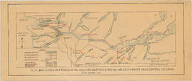
Greater Vancouver, British Columbia : regional major street plan

Item is a map which has been removed from a copy of the report "A plan for the City of Vancouver, British Columbia, including Point Grey and South Vancouver and a general plan of the region", commissioned by the Vancouver Town Planning Commission from the planning consultants Harland Bartholomew & Associates.

The map shows existing and proposed additions to the Greater Vancouver major street plan.

Harland Bartholomew and Associates

British Columbia : Port Moody sheet : west of seventh, east and west of coast meridians

Item is a map of the Lower Mainland of British Columbia, from the international border in the south to Britannia Beach in the north and from Sechelt Peninsula in the west to Chilliwack and Harrison Lake in the east. Map shows railways, railway stations, trails, roads surveyed, post offices, townships, and ranges.

Official highway map of British Columbia, northern Washington, Idaho and Montana

Item is a road map designed to be folded into a pamphlet. Primary map shows main roads, secondary roads, roads under construction and highway numbers in the southern half of British Columbia, northern Washington, northern Idaho and northern Montana. Three inset maps show the Trans-Canada Highway, Peace River highways and routes from Prince George to Hazelton. The item also contains information on government ferries, registration of foreign cars, British Columbia provincial parks, Dominion parks, camp fire permits and hours at British Columbia customs stations.

Plan to accompany agreement with the City of Vancouver

Item is a copy of a map of Sea Island, including the R.C.A.F. station. The right-hand side of the map is heavily annotated with buildings along the central south shore of the island and sea plan floats. Title is annotated "Building status plan colour coded" but there is no key to the colour coding.

Canada. Department of Transportation. Air Services Branch

City of Vancouver : Residential lots, Area B, Champlain Heights

Item contains information on the sale of lots in Champlain Heights by the City of Vancouver. A map shows lot numbers, lot sizes, lot values and sidewalk crossings in the area from Rosemont Drive in the north to 63rd Avenue in the south and from Butler Street in the east to Kerr Street in the west, and text outlines the details associated with sales.

B.C. Electric plan showing bus stops in Vancouver

Item contains three maps showing transit routes, bus stops and bus zones in the city of Vancouver. Inset maps show the "Seasonal 'round the park route and stops" in Stanley Park and the "University bus route" in the University Endowment Lands. The main map extends from Smith Avenue to Burrard Inlet to Blanca Street to Marine Drive.

Proposed Raymur Ave. [Avenue] Trunk Sewer diverting sewage from False Creek reclaimed area

Map shows the proposed Raymur Avenue Trunk Sewer to divert sewage away from the False Creek reclaimed area. It includes the area from Main Street to Clark Drive and from Alexander Street to Seventh Avenue. Streets and blocks are shown. The map is heavily annotated in ink and pencil to 1936. Indicated on the map are the locations of pumps, sewers, drains, and elevations; the Canadian National Railway (C.N.R.) Station, lines, industrial sites and proposed roadways; the Great Northern Railway (G.N.R.) Station and lines; a proposed rail yard; and the City Dump. Also noted is the water consumption of various companies in the area.

Proposed Raymur Ave. [Avenue] Trunk Sewer diverting sewage from False Creek reclaimed area

Map shows the proposed Raymur Avenue Trunk Sewer to divert sewage away from the False Creek reclaimed area. It includes the area from Main Street to Clark Drive and from Alexander Street to Seventh Avenue. Streets and blocks are shown. The map is annotated in ink and pencil with regard to top and bottom fill and water levels. A pencil diagram of the pump at Parker Street has been drawn at the top of the map. Also indicated are the locations of pumps; the Canadian National Railway (C.N.R.) Station, lines, industrial sites and proposed roadways; the Great Northern Railway (G.N.R.) Station and lines; and the City Dump.

Proposed Raymur Ave. [Avenue] Trunk Sewer diverting sewage from False Creek reclaimed area

Map shows the proposed Raymur Avenue Trunk Sewer to divert sewage away from the False Creek reclaimed area. It includes the area from Main Street to Clark Drive and from Alexander Street to Seventh Avenue. Streets and blocks are shown. The map was heavily annotated between 1936 and 1941, and a preliminary pumping layout to Clark Drive was added in December 1936. Also indicated are the locations of sewers, pumps, drainage and elevations; the Canadian National Railway (C.N.R.) Station, lines, industrial sites and proposed roadways; the Great Northern Railway (G.N.R.) Station and lines; a proposed rail yard; and the City Dump.

Plan showing locations of oil and gas seepages and oil wells in Fraser Valley, British Columbia

Item is a map which shows rivers and streams, oil and gas seepages, oil wells drilled, towns and villages and railway lines from Pitt Lake in the north to the United States border in the south and from Chilliwack in the east to the Strait of Georgia in the west.

Haggen, E.A.

Bus routes, city of Vancouver, November 26th, 1937

Item is a hand-drawn map showing additions to bus routes, proposed additions to bus routes, dates of bus route additions and miles of bus route additions in Vancouver. A November 26, 1937 edition of "The Buzzer" containing information on bus routes and a reproduction of the hand-drawn map has been affixed to the verso.

Plan of subdivision of D in lot 183 and subdivision of J in lot 182, City of Vancouver

Item is a subdivision map showing block and lot numbers of subdivisions D and J in lots 183 and 182 respectively. These areas are situated roughly between Burrard Inlet in the north and First Avenue in the south and between Victoria Drive in the east and Clark in the west.

Garden, Hermon and Burwell, Provincial Land Surveyors

Plan showing polling divisions, City of Vancouver B.C., as defined in by-law no. 2434

Item is a map of Vancouver drawn by the City Engineer's Office in November 1936 showing polling divisions and sites as defined in by-law no. 2434. Annotated on the map in ink are the December 1945 civic election results for each division for R. Rowe Holland, Esq., Parks Board Chairman. A portion of D.L. 319 has been shaded in red. Map is numbered M.62.

Plan of re-subdivision of lots 3 to 14, subn [subdivision] 2 of bk [block] 3. D.L. 391 & 392

Map shows the subdivision of lots in the block bordered by 31st Avenue East, 32nd Avenue East, St. Catherines Street and Windsor Street, at that time in the District of South Vancouver. Map is certified by the surveyor Arthur H. Holland, British Columbia Land Surveyor, and W.A. Pound, Reeve of the District of South Vancouver. It is unclear as to whether the map was commissioned by the Corporation of the District of South Vancouver.

Redevelopment plan for Jericho Department of National Defence lands

Item is a map showing proposed redevelopment of portions of former Department of National Defence lands in the Jericho area. The map shows existing city parks, D.N.D. lands to be taken over for parks and recreation, city owned land, single family land, town houses, garden apartments and town houses and proposed new roads. The map appears to have been removed from a report.

Vancouver (B.C.). Engineering Services

Plan of Cambie St. grounds

Item is a map showing parade grounds, grand stand and drill hall in the area from Dunsmuir Street to Cambie Street to Georgia Street to Beatty Street. Legend in bottom left corner shows symbols for the following: iron fence, wire screen, goal posts, C.P.R. railway, car tracks, trees and contours. A letter about map from Major Matthews adhered to top right corner. Pencil annotation showing 158th Battalion men's quarters by Major Matthews

Selected park programs for additional park sites 1959-1976

Item is a map showing park programs for 1959-1976. Map was most likely created by the parks department and includes a legend depicting the following information: program A (7,200,000), program B (18,000,000), program C (28,800,000), potential major park sites from which additional acreage is to be selected for each program and existing park sites. The map shows locations selected for alternative programs and locations omitted from alternative programs. Map shows street names and extends from Boundary Road to Stanley Park to University Endowment Lands to Lulu Island.

Development in the western portion of the Lower Mainland region, 1968

Item is a map showing residential, commercial, industrial, civic and institutional, parks and recreational and agricultural zoning in the Lower Mainland area, including West Vancouver, North Vancouver, Vancouver, Burnaby, Coquitlam, New Westminster, Richmond, Maple Ridge, Langley, Surrey, Delta and White Rock. Information has been added to a base map published by the Province of British Columbia.

Composite industrial map of the metropolitan area, Lower Mainland, British Columbia

Item is a map showing areas either occupied by industry or zoned for industry in the following municipalities of the Lower Mainland: Vancouver, New Westminster, North Vancouver, Port Coquitlam, Port Moody, Burnaby, Coquitlam, Delta, North Vancouver, Richmond, Surrey and West Vancouver. Industrial areas are categorized as either light or heavy industry. New housing developments, main traffic arteries, railways and municipal boundaries are also indicated.

West section Richmond municipality

Item is a copy of part of a published map of Richmond, B.C. The map shows lot numbers, post offices, dikes, streets, roads, swinging bridges, churches, schools, municipal boundaries and geographical features in the area from Marpole in the north to Gunn Island in the south and from Jacombs Road in the east to Sturgeon Bank in the west. The portion has been annotated with a grid, but information is included which indicates what the lines mean.

Results 201 to 250 of 1505