![[Coal Harbour and Downtown from the Causeway]](/uploads/r/null/d/f/5/df5783e376ce091eaa747d85bdac39ab081c295ffb29db71e675d1326a870c77/8b685d69-96da-4273-b4c4-226e0f99cfc5-CVA260-1224_142.jpg)
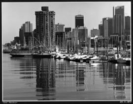
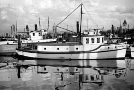
[Coal Harbour and Downtown from the Causeway]
- AM640-S1-: CVA 260-1224
- Item
- [ca. 1925]
Part of James Crookall fonds
462 results with digital objects Show results with digital objects
[Coal Harbour and Downtown from the Causeway]
Part of James Crookall fonds

Vancouver Rowing Club spring regatta at Coal Harbour
Part of Stuart Thomson fonds
Photograph shows spectators on wharf, arena in the background. The teams are the eights for the Vancouver Rowing Club and the University of Washington.

Vancouver Rowing Club spring regatta University of Washington Eight
Part of Stuart Thomson fonds

Vancouver Rowing Club Eight at V.R.C. spring regatta
Part of Stuart Thomson fonds
Photograph shows
![V.R.C. [Vancouver Rowing Club] Four & Double Crews for St. Catherines taken for Province [Coa...](/uploads/r/null/4/1/412abfd7acce1adb4cf991702a000fc50078e41d8f421a8fa725952a221a01fa/94279fbc-2dbd-412c-a040-10e1780bac99-A01461_142.jpg)
Part of Stuart Thomson fonds
![Mr. G.B. Warren, Pacific Motor Boat, loading yachts on scow [False Creek South]](/uploads/r/null/3/d/3d64427c867440e7d963d876580d7a96d4e51be7df567c1fc70173c55e3642d4/bca9a4db-6ce1-43f2-a5a9-4093881390a7-A01560_142.jpg)
Mr. G.B. Warren, Pacific Motor Boat, loading yachts on scow [False Creek South]
Part of Stuart Thomson fonds
![Mr. G.B. Warren, Pacific Motor Boat, loading yachts on scow [False Creek]](/uploads/r/null/3/d/3de4a6c7f897b524e96125c76b31a4f9cc8f0fdb760b732c70e777151e599f8e/538827c0-3fdd-4563-8064-633ec45e13e4-A01561_142.jpg)
Mr. G.B. Warren, Pacific Motor Boat, loading yachts on scow [False Creek]
Part of Stuart Thomson fonds
Imperial Gasoline signboard in background.
![Mr. G.B. Warren, Pacific Motor Boat, loading yachts on scow [False Creek]](/uploads/r/null/f/2/f232cac9c03fef859e1f5924b275b39d362d773c6832127117a54cac2812e910/5efc456e-cf3b-46c8-a964-4e3d5bb91ce3-A01562_142.jpg)
Mr. G.B. Warren, Pacific Motor Boat, loading yachts on scow [False Creek]
Part of Stuart Thomson fonds
The Port of Vancouver : Canada's key city of the West
Part of City of Vancouver Archives technical and cartographic drawing collection
Item is a brochure promoting Vancouver harbour as a hub of economic activity in the city. The brochure includes illustrations of harbour activity, facts about various aspects of the operations to show the harbour's capacity and facilities.
![Selma Park & Pender Harbour [view from ship] Union Steamship Co.](/uploads/r/null/b/9/b9d40aa8469fc3a5ae14b34b0fdf85b5f9ec7cd8f40da6b11fce28104c4472f4/6fb1525d-e302-4ee4-805a-e2bf36aebc66-A01740_142.jpg)
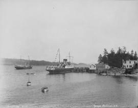
Selma Park & Pender Harbour [view from ship] Union Steamship Co.
Part of Stuart Thomson fonds
![["Lady Cecilia" docked at harbour]](/uploads/r/null/2/6/26b7ebe5c05ab80105c1df787e186e353667dcbdbecc67b47b659952e02e9dc6/8b9f7e20-3108-4850-9ec2-d1e854bd5c1c-A01748_142.jpg)
["Lady Cecilia" docked at harbour]
Part of Stuart Thomson fonds
![["Lady Cecilia" docked at harbour]](/uploads/r/null/1/2/12849060169b219d0d918c4fa6a5bc5ee3fa04eb4ffc689f2afacc52cd3d40d7/8cda520d-0c78-4b29-9d3c-a1d0564d1c4a-A01756_142.jpg)
["Lady Cecilia" docked at harbour]
Part of Stuart Thomson fonds
Vancouver Harbour : plan of south shore, Burrard Inlet between Heatley Ave. and Victoria Dr.
Part of City of Vancouver Archives technical and cartographic drawing collection
Item is a map which shows parcels of land along Burrard Inlet and district lots in downtown Vancouver. Piers, factories and mills along the waterfront are identified. Soundings are shown in feet.

View of Fisherman's Cove taken from highway to Horseshoe Bay
Part of Vancouver Express fonds

Empress of China at dock, 1906, Vancouver, B.C.

'Greenhill Park' ship explosion in Vancouver Harbour
Unique waterway of Canada's Pacific Coast
Item describes the exploration of a freshwater harbour on the Pacific Coast.
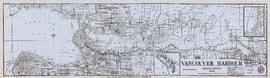
Vancouver Harbour, British Columbia, 1945
Part of City of Vancouver Archives technical and cartographic drawing collection
Item is a nautical chart showing English Bay and Burrard Inlet with soundings in feet, anchorages, locations of submarine cables, and ferry lines. Land features include city blocks and district lot numbers. Includes inset maps of the North Arm of Burrard Inlet and Vancouver Island. Note at the bottom of map states, "Not to be used for navigational purposes."
![View of ships in harbour [and docks and tracks]](/uploads/r/null/7/8/78e892a7a5987f84f3592b809c8131cb0defbfc6010483c78e9e826ed427c3d7/72d2f4f6-bf06-45c0-b07e-4a38693211c9-A17067_142.jpg)
View of ships in harbour [and docks and tracks]
Part of Stuart Thomson fonds
Photograph shows log booms.

Vancouver Harbour : Sheet 3 (Second Narrows to Port Moody)
Part of City of Vancouver Archives technical and cartographic drawing collection
Item is a nautical chart of Vancouver Harbour from Second Narrows in the west to Port Moody in the east, showing soundings in fathoms, tidal information, anchorages, beacons, and waterfront businesses. Street names are shown on land areas.

Vancouver Harbour : Sheet 1 (First Narrows to Second Narrows)
Part of City of Vancouver Archives technical and cartographic drawing collection
Item is a nautical chart of Vancouver Harbour from First Narrows in the west to Second Narrows in the east, showing soundings in fathoms, tidal information, anchorages, beacons, and waterfront businesses. Street names are shown on land areas.

Vancouver Harbour : Sheet 2 (Point Grey to Second Narrows)
Part of City of Vancouver Archives technical and cartographic drawing collection
item is a nautical chart of Burrard Inlet and Vancouver Harbour from Point Grey in the west to Second Narrows in the east, showing soundings in fathoms, tidal information, anchorages, beacons, and waterfront businesses. Street names are shown on land areas. A Royal Canadian Air Force bombing range at Jericho Beach is identified as a danger area.

Part of Major Matthews collection
J.S. Matthews' notes with print or negative in Archives.
![[View of Deadman's Island and Coal Harbour]](/uploads/r/null/8/0/80683adb4e0b7498798804e3d05daf6be844a6f263642f946a52c6c79c258681/c2f926a9-4ca4-48d8-a08d-207d4325c9b1-A08035_142.jpg)
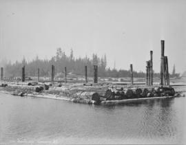
[View of Deadman's Island and Coal Harbour]
Part of Major Matthews collection
J.S. Matthews' notes with print or negative in Archives.
![[Ships in Vancouver Harbour]](/uploads/r/null/d/6/d629566f7cb9f7a78af71c85ba3ea4a2cf7167728b91400cee1d65fd777443b3/fbfab785-d4fa-4637-8632-cf9d4b4bddca-A08055_142.jpg)
Part of Major Matthews collection
J.S. Matthews' notes with print or negative in Archives.
![[Vancouver Rowing Club clubhouse and dock, in Coal Harbour at the foot of Bute Street]](/uploads/r/null/d/2/d2f7d67e632b7c2d17d9142941c783d2817e1558aba2c484ce203583c6a8b56a/2fcab23e-13cb-44cf-890c-3ddcdfa34b69-A08054_142.jpg)
[Vancouver Rowing Club clubhouse and dock, in Coal Harbour at the foot of Bute Street]
Part of Major Matthews collection
J.S. Matthews' notes with print or negative in Archives.
![[Vancouver Rowing Club clubhouse and dock in Coal Harbour at the foot of Bute Street]](/uploads/r/null/8/7/8718dcec36599374e6ce423106f3bb1e50b1b752d8db507d8b08007effe02300/1f6af934-f999-44dd-9061-62c3594bc3e6-A08053_142.jpg)
[Vancouver Rowing Club clubhouse and dock in Coal Harbour at the foot of Bute Street]
Part of Major Matthews collection
J.S. Matthews' notes with print or negative in Archives.

Scenes of ships in harbour, English Bay, tennis courts and mountain views
Part of Olga Jenkinson Bell fonds
Item is a page from an album with photographs showing scenes of ships in harbour, English Bay, tennis courts and mountain views.
![[View of Coal Harbour showing Pier D, dredging, and C.P. railway yard]](/uploads/r/null/a/f/af0c10ae5aeb61ca4a197b4e372f1862f6fa32fb58347e2b94148897eec5e3c3/a7b91197-362d-42d1-b2a2-df14d10f4656-A63942_142.jpg)
[View of Coal Harbour showing Pier D, dredging, and C.P. railway yard]
Part of Major Matthews collection
Photograph shows Pier A to the left and a north shore ferry to the right.
![Vancouver Harbour Sept. 1913 [showing the C.P.R. Station and yard and Pier D under construction]](/uploads/r/null/0/5/056455d9e690740168b8f4ae0d8d18b148b46061376f6b258e46b96ab0527cb1/82d16629-54f2-49c5-9a22-bf507e3921f0-A63186_142.jpg)
Vancouver Harbour Sept. 1913 [showing the C.P.R. Station and yard and Pier D under construction]
Part of Major Matthews collection

Part of Major Matthews collection
Photograph also shows downtown Vancouver and Stanley Park in the background.
![[View of] Vancouver [harbour]](/uploads/r/null/5/3/e/53ebf8e635066e530178fc0ae20760af8e63cd463f234fe8147486ff21079622/ccc78739-a015-4e39-89ae-adbd98ea7824-CVA256-01_142.jpg)
Part of Elizabeth Abbott fonds
![[Northern view of downtown Vancouver from the World Building at 500 Beatty Street]](/uploads/r/null/c/5/c5a97982fe48806e527a2356c3596800ee386904520184558d1eb65128635907/f3ea7ce2-2a4c-40da-a5a9-2ccfa6c170b1-A63886_142.jpg)
[Northern view of downtown Vancouver from the World Building at 500 Beatty Street]
Part of Major Matthews collection
Photographs shows Central Public and Vancouver High Schools, the Dominion Bank and Vancouver Daily Province Buildings, Coal Harbour, C.P.R. Pier D and Deadman's Island and the North Shore in the background
![[Northern view of downtown Vancouver from the World Building at 500 Beatty Street]](/uploads/r/null/9/5/95cc16c6b26e463eb28bc5ac8abec9ec6723150a2aefbca7850f264a2adff766/e88985ba-abeb-4d06-8eea-2bf10a834381-A63885_142.jpg)
[Northern view of downtown Vancouver from the World Building at 500 Beatty Street]
Part of Major Matthews collection
Photographs shows Central Public and Vancouver High Schools, the Dominion Bank and Vancouver Daily Province Buildings, Coal Harbour, C.P.R. Pier D and Deadman's Island and the North Shore in the background.

Part of William Orson Banfield fonds

The visit of the fleet : H.M.S. Repulse in the harbor
Part of William Orson Banfield fonds
![West Coast trip [with Sherwood Lett, Arthur Lord, W.O. Banfield] : Victoria Harbor](/uploads/r/null/1/a/e/1aeb4a3bc33b7d8193df08812fdb554308428cb72e2c2037cb92b54e2c4ab46b/4e8dd226-9d82-4de4-9fe8-fabe4622f1f9-CVA289-003_142.jpg)
West Coast trip [with Sherwood Lett, Arthur Lord, W.O. Banfield] : Victoria Harbor
Part of William Orson Banfield fonds

The New Parliament Buildings, Victoria
Part of William Orson Banfield fonds
![Vancouver Harbour from the Stadacona [Apartment Building]](/uploads/r/null/a/d/a/adad648f7aa2e6b96320fda8037a95ccb21b883a2daafadc021660a228ca983f/ab1ae707-0322-41fe-8c37-3456ba2ca84d-CVA289-038_142.jpg)
Vancouver Harbour from the Stadacona [Apartment Building]
Part of William Orson Banfield fonds
![[Southwest facing cityscape view of the West End]](/uploads/r/null/4/b/4b50b8139a75294378d4e28c633eb1a7201b7a1ffba30b79f1cf631026c1a7bd/4f7badb7-4d85-4c22-8780-a7311c11a932-A59250_142.jpg)
[Southwest facing cityscape view of the West End]
Part of City of Vancouver fonds
Photograph also shows English Bay
![[Northwest facing cityscape view of the West End]](/uploads/r/null/8/1/8144b464121d2d606915a295fe4bfea95b903893f4ac909e59d22d27b3a6c7db/c58f4286-e96d-4189-ad75-9885f1b17ff7-A59249_142.jpg)
[Northwest facing cityscape view of the West End]
Part of City of Vancouver fonds
Photograph also shows buildings in the West End, English Bay, Stanley Park, Coal Harbour, Burrard Inlet, and the North Shore
Vancouver skyline from Coal Harbour [Boats docked in marina: "Cohoe Bay" and "Sal Lal"]
Part of Karl Haspel fonds
Your port and you : see the water! See your port!
"What's inside . . . Port Vancouver year-round recreation map . . . port news . . . "
![[View of Empress Hotel taken from inner harbour]](/uploads/r/null/8/d/8d8d1dfc7f784994ae144478452634025ae389b410f8c73b66c10e64907f2901/bb1420c3-35d0-474a-8b94-85423c9cf348-A15720_142.jpg)
[View of Empress Hotel taken from inner harbour]
Part of Stuart Thomson fonds

Map of the harbour of New Westminster, British Columbia
Part of City of Vancouver Archives technical and cartographic drawing collection
Item is a map showing the Fraser River and its North Arm as well as the Westminster Waterway surrounding New Westminster. A key map shows the location of New Westminster in relation to the Greater Vancouver area.

Vancouver Harbour, foot of Cardero Street
Part of City of Vancouver fonds
Item is a photograph showing boats in the harbour at the foot of Cardero Street. Boats shown include the "Victorac" and the "Reel Fisher".