
- AM54-S4-1-A-6-: A-6-66
- Item
- [186-?]
Part of Major Matthews collection
Part of Major Matthews collection
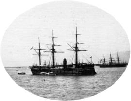
H.J.M. ship "Balliquest" - Iron Clad
Part of Major Matthews collection
Part of Major Matthews collection

Part of Major Matthews collection

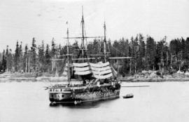
H.M. Ships "Grappler", "Shearwater" and "Malacca"
Part of Major Matthews collection

Part of Major Matthews collection

Part of Major Matthews collection
Part of Major Matthews collection

Part of Major Matthews collection
Photograph shows a First Nations woman and boy near the dwelling.
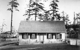
Residence of Foreman of Dockyard
Part of Major Matthews collection
Road Leading to Dockyard - Esquimalt
Part of Major Matthews collection
Photograph shows the telegraph office, church and other buildings.
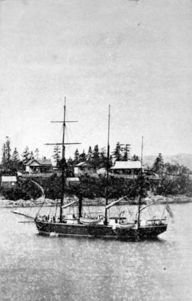
![Thetis Island [in] Esquimalt [Harbour]](/uploads/r/null/4/4/4489a3d594f5cfe6745f5e2a5de234cc433a82fe9ed8a0be43a4418899df2b7e/5297edf5-fd8d-49ef-a6be-ccdba53b452b-A22926_142.jpg)
Thetis Island [in] Esquimalt [Harbour]
Part of Major Matthews collection
![[Head and shoulders portrait of] Mr. Robinson](/uploads/r/null/7/6/769b67733140fae7b86ea921ce48289d25dedc60e398101d23d36f3d10d6851a/6d474e3a-eee3-449d-9ee1-93f486ad1566-A63178_142.jpg)
[Head and shoulders portrait of] Mr. Robinson
Part of Major Matthews collection
![[Semlin and Parke Bonaparte House on the Cariboo Trail]](/uploads/r/null/7/7/77096992f21809e9fe5a102d8d0f0cfe0ced1d006eca1c874dbc974776356c9a/14448636-e9aa-4c0f-bd7a-7ebb6fa3fb55-A26931_142.jpg)
[Semlin and Parke Bonaparte House on the Cariboo Trail]
Part of Major Matthews collection
![[Victoria Volunteer Rifle Corps also known as "The African Rifles"]](/uploads/r/null/a/4/a46cfceaaf41efface9c36e8f348883d663e0fa7bbf0e52ef6e131db02c318de/80e181fd-e646-4d08-951b-944ce4c1d55d-A32148_142.jpg)
[Victoria Volunteer Rifle Corps also known as "The African Rifles"]
Part of Major Matthews collection
![[View of the British Garrison at] San Juan](/uploads/r/null/0/f/0f1437452ca2a7b285ae1da89a8614c4b42987d1eaad6b306291788223454918/e5280f9b-8b87-4dbc-9023-c68bd8014efd-A26906_142.jpg)
[View of the British Garrison at] San Juan
Part of Major Matthews collection
Part of Hamber family fonds
A note on the back of the photograph reads: "Granville and Hastings, ca. 1868."
![[Full length studio portrait of] Mr. Pooley [with dog]](/uploads/r/null/a/2/a27e0a8db60464541872b14342a6d26966962f4a84c34e53c640344899a006f5/63cffdff-ed88-4c72-be13-a0899db7c997-A02509_142.jpg)
[Full length studio portrait of] Mr. Pooley [with dog]
![[Head and shoulders studio portrait of man]](/uploads/r/null/7/d/7d5e841c09e60358808bb9261f928d9512245d7f5016041ce21c52e2d987e0fa/5bae1174-7125-4473-809a-77eaecfafd0b-A02142_142.jpg)
[Head and shoulders studio portrait of man]
![[Head and shoulders studio portrait of] Bob Stevenson, great friend of Gov. Douglas, early Caribo...](/uploads/r/null/4/e/4e0441b3aeda618877c3bed450e93734672a25b113a40367314f723db6544fad/530237da-b50d-41d0-b417-0fe8e4813973-A02505_142.jpg)
A note on the original accompanying envelope reads: "Steveson, Robert, partner to Cameron of Cameron Mine - Cariboo."
![[Seated studio portrait of] Peter O'Reilly, H. M. Ball, and Thomas Elwyn](/uploads/r/null/f/a/fa6276fb9af30402af8457b184990d0165c45f7f79c113e1d469db543c67cd21/9a2a0abd-185c-4c2d-94da-5d9fa119fe9f-A02514_142.jpg)
[Seated studio portrait of] Peter O'Reilly, H. M. Ball, and Thomas Elwyn
![[Studio portrait of baby]](/uploads/r/null/0/c/0c10964730bd2dcd64806fc6e8a86ab53f0e396028fa2158962d5f2cd109a03d/0e3f16ed-cf0f-49a9-bb4a-838c4cca95d9-A01832_142.jpg)
![[Studio portrait of woman]](/uploads/r/null/d/6/d6c027014e7fd7305cada8ca498472b827d4c4e9cb1037e8b59072efe050726d/0bc80faf-de18-4e70-80b0-de59dc8954b2-A02118_142.jpg)
![[Osborne J. Pierce]](/uploads/r/null/2/3/237c61c9ad88467482f99b90469506e254687c51197d822d142c82dc52cf1b1e/a71e515c-3934-431f-9ca2-abcc0ddea5dc-CVA1477-435_142.jpg)
Part of L.D. Taylor family fonds
Full-length studio portrait.

Map of the United States and territories together with Canada etc.
Part of City of Vancouver Archives technical and cartographic drawing collection
Item is a map showing the boundaries of U.S. territories and states and the southern portion of Canadian colonies of Vancouver Island, British Columbia, Canada East, Canada West, as well as New Brunswick, Prince Edward Island and Nova Scotia. The map also shows cities and principal geographical features. Two inset maps show "Hampton Roads and Norfolk Harbour" and "Pensacola Bay" in greater detail.

Part of City of Vancouver Archives technical and cartographic drawing collection
Item is a copy of a portion of a British Admiralty hydrographic survey of Burrard Inlet. The copied portion shows the area from First Narrows to just east of Capital Hill. The map shows soundings in the Inlet, as well as indications of topography of the surrounding shoreline areas.

Map of a portion of British Columbia
Part of City of Vancouver Archives technical and cartographic drawing collection
Item is a map showing exploration routes by Lieutenant Palmer, R.E., May and June 1859; Lieutenant Mayne, R.N., May 1859; and Lieutenant Palmer, R.E., Sept. & Oct. 1859. The map also shows "practicable roads" in the southwestern portion of British Columbia. Annotations are colour added to the map to more easily distinguish the different routes depicted.

British Garrison, San Juan Island
Part of Major Matthews collection

North America. West Coast. Fraser River and Burrard Inlet
Part of City of Vancouver Archives technical and cartographic drawing collection
Item is a nautical chart which show details of area surveyed from Pitt Lake in the north to Roberts Bank in the south and from (what is now) Harrison Hot Springs in the east to Bowen Island in the west. The chart shows soundings in Burrard Inlet, and along the Fraser River.

Part of Major Matthews collection
Photograph shows Christ Church Cathedral

Officers' Quarters, San Juan Island
Part of Major Matthews collection
![San Juan and H.M.S. "Boxer" [and] Pritchard's Sloop](/uploads/r/null/4/0/40ea9d4528a5c4b3ec98885eff16456bc19f0ae6554095f5ff1b3ac7f407a63f/a498747b-10ca-40c7-b9b8-07567f9976ae-A26902_142.jpg)
San Juan and H.M.S. "Boxer" [and] Pritchard's Sloop
Part of Major Matthews collection
![[Head and shoulders studio portrait of man]](/uploads/r/null/9/8/98b54b50f6870b63101de1443be7748483fbe620fb4034b78053fde388457a2e/0316f71d-23db-4e31-a557-3a9a114c1f59-A02168_142.jpg)
[Head and shoulders studio portrait of man]
![[Head and shoulders studio portrait of] Judge Crease](/uploads/r/null/1/6/1681e97a4ac2f5c6a0fd1a36c87f74bbf3577359418ebe0ce017e1951b17b460/7b91a051-7c68-4a83-be6a-1d173d8dff2e-A02507_142.jpg)
[Head and shoulders studio portrait of] Judge Crease
![[Head and shoulders studio portrait of] Lawrence William Manson](/uploads/r/null/b/a/ba7dbb93717d6456ca69753d97d6096be0c1b27206bb8a8f1ec2b65c51537972/ecbbfc00-1fa9-4dea-bc89-46efa7f1229d-A02510_142.jpg)
[Head and shoulders studio portrait of] Lawrence William Manson
![[Head of shoulders studio portrait of] Jeff D. Howall](/uploads/r/null/1/4/14889a3214159fee22966907b463a03d4affc979353fd4c5abaec208441d5e5e/a308b62e-4ac3-40df-8c38-ca6ff6babb37-A02125_142.jpg)
[Head of shoulders studio portrait of] Jeff D. Howall
![[Seated studio portrait of man, showing chairs and table]](/uploads/r/null/4/0/40ea395b0a15cadce58afc3788bdd2d50433e0c040d1973f97ab1744cc6dafc9/4568bf28-ad62-4997-a3e1-c452de01bc44-A02141_142.jpg)
[Seated studio portrait of man, showing chairs and table]
![[Studio portrait of girl and boy]](/uploads/r/null/9/f/9fd407135e9c5a60b73b8f29a01c1f7e89372e3fba328747e94e417bf71c7ab6/2ec2f003-d925-4a15-b608-abcc83142c1f-A02117_142.jpg)
[Studio portrait of girl and boy]
Photograph shows a girl standing and a boy seated.
![[Studio portrait of older woman in lace cap, seated at a table]](/uploads/r/null/b/5/b5e63d5c5ae72068186399279790513c62ab6293ca58c020c2e136d2aa4dfcae/d77375f7-11d0-4b03-8484-7de46b2ec87b-A02145_142.jpg)
[Studio portrait of older woman in lace cap, seated at a table]
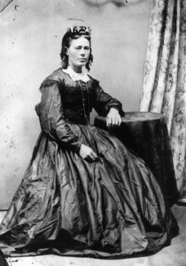
Portrait of Katherine Cordiner
Item is a portrait of Katherine (Mrs. Peter) Cordiner, teacher at Hastings Sawmill School, 1874-1880.
![[Henry Hickman]](/uploads/r/null/d/5/d5a4d8a7804fb1ac533f687a628f20c3b2b1b20f8dcadcdac479d91f5af23205/56843a41-5242-4b2c-8f2e-8bf8b4a2979e-A35986_142.jpg)
Part of Major Matthews collection
Studio portrait
![Oaklands [Oakland] - opposite San Francisco](/uploads/r/null/0/b/0bf8abeabe3284efbe6d52ae3a9b98e07bfefee5bf08447952070b396993421d/f5726b8f-fe1a-48c9-81d6-418a1eecf8a8-A23084_142.jpg)
Oaklands [Oakland] - opposite San Francisco
Part of Major Matthews collection
Part of Major Matthews collection
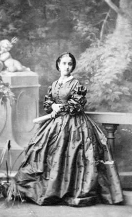
Studio portrait of a young woman

Residence of Paymaster of Dockyard - Esquimalt
Part of Major Matthews collection
![Steamer "Onward" [on the] Frazer [Fraser] River](/uploads/r/null/1/2/12c7dd8314d79146e8c106ae2679b56ba1b1665eb9995779eddd510e52285a10/b4acb919-102e-44aa-9137-ce83364f3618-A22910_142.jpg)
Steamer "Onward" [on the] Frazer [Fraser] River
Part of Major Matthews collection
![Suspension Bridge - Frazer [Fraser] River](/uploads/r/null/f/d/fd8dc71b367897655629c415eb95fd5db096c3073e913c642d2318d041a2b6e5/e03316a1-8594-4826-b4c1-8663a9c77c25-A22915_142.jpg)
Suspension Bridge - Frazer [Fraser] River
Part of Major Matthews collection

Part of Major Matthews collection

Part of Major Matthews collection
Photograph shows the buildings and waterfront at Victoria.