Water service map of South Vancouver : Victoria Drive to Vivan Street and 67th Avenue (65th Avenue) to North Arm of Fraser River
Water service map of South Vancouver : Doman Street to Park Street (Boundary Road) and 67th Avenue (65th Avenue) to North Arm of Fraser River
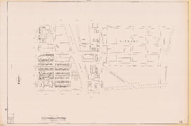
Plan of re-subdivision of lots 3 to 14, subn [subdivision] 2 of bk [block] 3. D.L. 391 & 392
Vest pocket map of Vancouver : map B
Southerly portion. Vancouver Island
Plan of the City of Vancouver, British Columbia
Plan of subdivision of part of D.L. 526 : South Vancouver
Plan of part of subdivision of district lot 540. South Vancouver
Vancouver
City of Vancouver
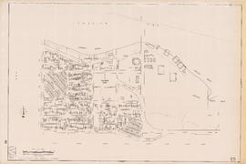
[Third section of] Shaughnessy Heights
Plan of the City of Vancouver, B.C.
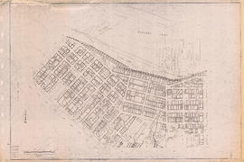
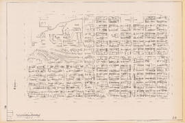
Sectional map [Kaslo Street to Yale Street to Cotton Drive to East 1st Avenue]
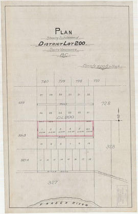
Plan shewing subdivision of District Lot 200. South Vancouver, B.C.
Plan of New Westminster City and suburban lots
[Vancouver, B.C. : district lots]
Map of part of the New Westminster District shewing the proposed new municipality of Burnaby
Plan showing lands occupied in Stanley Park near Brockton Point, City of Vancouver, B.C.
North Arm Road, 1876. North Arm, Fraser River
Map of the Lower Mainland showing municipal boundaries and lot numbers
Plan of subdivision of part of D.L. 526, New Westminster District, B.C., Kitsilano, City of Vancouver
Hastings Townsite : Nanaimo Street to Renfrew Street and Burrard Inlet to Cambridge Street
Hastings Townsite : Rupert Street to Boundary Road and Pender Street to Charles Street
Plan of the City of Vancouver
Sectional map of Vancouver showing streets, block and lot outlines, and building perimeters : Map 7 : Burrard Street to Main Street and Burrard Inlet to Georgia Street
Sectional map of Vancouver showing streets, block and lot outlines, and building perimeters : Map 10 : Clark Drive to Nanaimo Street and Burrard Inlet to Frances Street/Ferndale Street
Sectional map of Vancouver showing streets, block and lot outlines, and building perimeters : Map 16 : Rupert Street to Boundary Road and Kitchener Street to 5th Avenue
Sectional map of Vancouver showing streets, block and lot outlines, and building perimeters : Map 21 : False Creek waterfront and adjacent buildings from foot of Drake Street to Main Street
Sectional map of Vancouver showing streets, block and lot outlines, and building perimeters : Map 25 : Blanca Street to Jericho Beach Park and English Bay to 4th Avenue
Sectional map of Vancouver showing streets, block and lot outlines, and building perimeters : Map 28 : Camosun Street to Balaclava Street and 4th Avenue to 14th Avenue
Sectional map of Vancouver showing streets, block and lot outlines, and building perimeters : Map 29 : Balaclava Street to Maple Street and 3rd Avenue to 14th Avenue
Sectional map of Vancouver showing streets, block and lot outlines, and building perimeters : Map 30 : Maple Street to Oak Street and 3rd Avenue/6th Avenue to 14th Avenue
Sectional map of Vancouver showing streets, block and lot outlines, and building perimeters : Map 31 : Oak Street to Main Street and 6th Avenue/4th Avenue to 16th Avenue
Sectional map of Vancouver showing streets, block and lot outlines, and building perimeters : Map 38 : Nanaimo Street to Rupert Street and Grandview Highway to 22nd Avenue
Sectional map of Vancouver showing streets, block and lot outlines, and building perimeters : Map 45 : Discovery Street/Camosun Street to Blenheim Street and 14th Avenue to King Edward Avenue
Sectional map of Vancouver showing streets, block and lot outlines, and building perimeters : Map 53 : Inverness Street to Nanaimo Street and 32nd Avenue to 41st Avenue
Sectional map of Vancouver showing streets, block and lot outlines, and building perimeters : Map 54 : Nanaimo Street to McHardy Street/Cecil Street/Joyce Street and Ward Street/Euclid Avenue/Vanness Avenue to 41st Avenue
Sectional map of Vancouver showing streets, block and lot outlines, and building perimeters : Map 59 : Quebec Street to Inverness Street and 37th Avenue to 47th Avenue
Sectional map of Vancouver showing streets, block and lot outlines, and building perimeters : Map 64 : Balaclava Street to Cypress Street and 41st Avenue to 49th Avenue
Sectional map of Vancouver showing streets, block and lot outlines, and building perimeters : Map 65 : Camosun Street to Carnarvon Street and 33rd Avenue to 41st Avenue
Sectional map of Vancouver showing streets, block and lot outlines, and building perimeters : Map 70 : Macdonald Street to Cypress Street and 49th Avenue to 57th Avenue
Sectional map, city of Vancouver, B.C. : Renfrew Heights, subdivision in a part of the town of Hastings, suburban lands
Portions of New Westminster District and Vancouver Island
Port Moody, the western terminus of the Canadian Pacific Railway


![Plan of re-subdivision of lots 3 to 14, subn [subdivision] 2 of bk [block] 3. D.L. 391 & 392](/uploads/r/null/4/a/4a0ea6aa076433c7bcad0c847f7acb3bb1046f7abf2801c48b97d9ca58f49a73/9bd508e4-c85e-4090-b266-27571c5d4dbc-MAP754_142.jpg)


![[Third section of] Shaughnessy Heights](/uploads/r/null/b/9/c/b9c97036cadac8b6ffc53f2380c1c158d767da3473d29ad1b04968cc742d132e/0301116d-9946-489d-a272-9d6453523103-MAP331_142.jpg)

![Sectional map [Kaslo Street to Yale Street to Cotton Drive to East 1st Avenue]](/uploads/r/null/5/b/5b3ce173622ff68f920706abdf2b71af76caf9469cb2cbd3346b37f55694015e/4e7b285b-63cb-45b1-8e0c-6002788dbae6-MAP427_142.jpg)

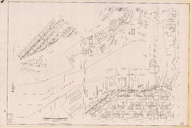
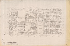
![[Vancouver, B.C. : district lots]](/uploads/r/null/4/a/4a5c15633319c3754d3aa0cc525470bfebcf5a98ad8caeedf44b777194f300bd/2f055d65-47f7-4679-bb91-66b8f1843d2f-MAP531_142.jpg)