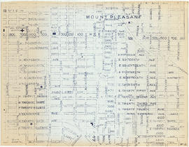
![Plate 107 [Quebec Street to Dufferin Street to Manitoba Street to Fifth Avenue]](/uploads/r/null/0/d/7/0d79d0f2e59b2acf6f0b094b86112948aced989bd8c13eb8f8ac17f5cb05a1fd/b74906fe-c1a9-49b1-8bc5-37b4141108f6-1974-100_142.jpg)
Plate 107 [Quebec Street to Dufferin Street to Manitoba Street to Fifth Avenue]
- AM1594-MAP 625-: 1974-100.11
- Item
- Sept. 1905
Part of City of Vancouver Archives technical and cartographic drawing collection
1440 results with digital objects Show results with digital objects
Plate 107 [Quebec Street to Dufferin Street to Manitoba Street to Fifth Avenue]
Part of City of Vancouver Archives technical and cartographic drawing collection
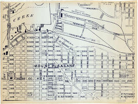
![Plate 106 [Manitoba Street to Dufferin Street to Alberta Street to Fifth Avenue]](/uploads/r/null/a/2/8/a288bcdc881a84d269c058cb38c117c43ef34c68d4a36dd1ffa72bfc2a46ba60/2d5baff6-456c-4406-9faf-fdd562e492b0-1974-100_142.jpg)
Plate 106 [Manitoba Street to Dufferin Street to Alberta Street to Fifth Avenue]
Part of City of Vancouver Archives technical and cartographic drawing collection
![Plate 105 [Front Street to False Creek to Quebec Street to Dufferin Street]](/uploads/r/null/a/f/b/afbb9be25514350d408eefa5865173e3a489ecdb6752d6b3096564052b234ca4/8c126ea6-16bb-4f0b-8131-a16f2a686d95-1974-100_142.jpg)
Plate 105 [Front Street to False Creek to Quebec Street to Dufferin Street]
Part of City of Vancouver Archives technical and cartographic drawing collection
![Plate 104 [Quebec Street to False Creek to Manitoba Street to Dufferin Street]](/uploads/r/null/b/3/b/b3b42c0352bed859e94ea30004ddb12475eea99c16a153542be22e644023b5ac/98b44bb6-b7b2-4f4c-aa2e-1d090030146e-1974-100_142.jpg)
Plate 104 [Quebec Street to False Creek to Manitoba Street to Dufferin Street]
Part of City of Vancouver Archives technical and cartographic drawing collection
![Plate 103 [Manitoba Street to False Creek to Dufferin Street]](/uploads/r/null/0/8/7/0878dcb1525256aa0f6a2ddfe63ea87046dd130caf68b3d7632593fb9d0e805f/b9950050-5631-4c4c-ac19-d2f7d1e8440a-1974-100_142.jpg)
Plate 103 [Manitoba Street to False Creek to Dufferin Street]
Part of City of Vancouver Archives technical and cartographic drawing collection
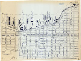
![Plate 102 [Front Street to False Creek to Cambie Street Bridge]](/uploads/r/null/2/3/4/23495fedf0cfd0840f946ff51151c2d620ac4381afedbd39cc496162211c108a/798a5687-2c56-4add-bf27-5adb8e27ebeb-1974-100_142.jpg)
Plate 102 [Front Street to False Creek to Cambie Street Bridge]
Part of City of Vancouver Archives technical and cartographic drawing collection
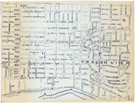
![Plate 101 [Alberta Street to False Creek to Bridge Street to Fifth Avenue]](/uploads/r/null/3/a/c/3ac4671c467690486217deca7d5b3609b605b6fc542b79fb134372abed97a952/1e879c50-27f7-4e55-8d48-ae8d72b27441-1974-100_142.jpg)
Plate 101 [Alberta Street to False Creek to Bridge Street to Fifth Avenue]
Part of City of Vancouver Archives technical and cartographic drawing collection
![Plate C [Index map of Vancouver - eastern portion]](/uploads/r/null/8/b/6/8b6eb59bc4a531f865d7df228919b13fa3b1b60a5776762d5d955cc44c5b8db5/83254bae-fa92-4283-82e4-0a09c85c0b9e-1974-100_142.jpg)
Plate C [Index map of Vancouver - eastern portion]
Part of City of Vancouver Archives technical and cartographic drawing collection
![Plate B [Index map of Vancouver - central portion]](/uploads/r/null/3/3/6/336c664924c5e585334207b2fe0914ca7325cbf0099b84ef15ac10c18e7792d9/5b4fc691-1bcd-4a8e-864a-16ebbe062389-1974-100_142.jpg)
Plate B [Index map of Vancouver - central portion]
Part of City of Vancouver Archives technical and cartographic drawing collection
![Plate A [Index map of Vancouver - western portion]](/uploads/r/null/0/d/0/0d022ba039f0508a397a4d35450b667671f0ef36fd388f800f51681434d2a2a9/795dc4f4-e794-4288-880d-6bd4de616417-1974-100_142.jpg)
Plate A [Index map of Vancouver - western portion]
Part of City of Vancouver Archives technical and cartographic drawing collection

Index to streets and block numbers
Part of City of Vancouver Archives technical and cartographic drawing collection
Insurance plan of Vancouver, British Columbia. Volume two
Part of City of Vancouver Archives technical and cartographic drawing collection
Item is the second volume of a fire insurance plan incorporating the "old" City of Vancouver south of False Creek only, and the City of North Vancouver. The volume includes key plans for each city, as well as an index of streets and blocks for Vancouver.
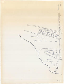
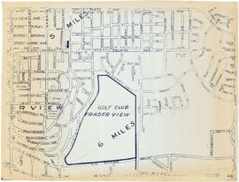
Sheet 31 : Camosun Street to Shaughnessy golf course to Fraser River to Salish Drive
Part of City of Vancouver Archives technical and cartographic drawing collection
Item is a reproduction of a section of an unknown map.

Sheet 28 : Main Street to Twenty-ninth Avenue to Granville Street to Fiftieth Avenue
Part of City of Vancouver Archives technical and cartographic drawing collection
Item is a reproduction of a section of an unknown map.

Sheet 26 : Highbury Street to English Bay to Tasmania Boulevard to Seventeenth Avenue
Part of City of Vancouver Archives technical and cartographic drawing collection
Item is a reproduction of a section of an unknown map.

Sheet 25 : Balaclava Street to Fifteenth Avenue to Blanca Street to Thirty-fifth Avenue
Part of City of Vancouver Archives technical and cartographic drawing collection
Item is a reproduction of a section of an unknown map.
Sheet 24 : Balaclava Street to English Bay to Tolmie Street to Nineteenth Avenue
Part of City of Vancouver Archives technical and cartographic drawing collection
Item is a reproduction of a section of an unknown map.

Sheet 23 : Vine Street to Forty-first Avenue to Salish Drive to Fraser River
Part of City of Vancouver Archives technical and cartographic drawing collection
Item is a reproduction of a section of an unknown map.
Sheet 22 : Vine Street to Thirty-first Avenue to Camosun Street to Fifty-first Avenue
Part of City of Vancouver Archives technical and cartographic drawing collection
Item is a reproduction of a section of an unknown map.

Sheet 21 : Cypress Street to West Fifteenth Avenue to Highbury Street to Thirty-fifthe Avenue
Part of City of Vancouver Archives technical and cartographic drawing collection
Item is a reproduction of a section of an unknown map.

Sheet 20 : Granville Street to English Bay to Trutch Street to West Sixteenth Avenue
Part of City of Vancouver Archives technical and cartographic drawing collection
Item is a reproduction of a section of an unknown map.

Sheet 19 : Cambie Street to Fifty-seventh Avenue to Arbutus Street to Fraser River
Part of City of Vancouver Archives technical and cartographic drawing collection
Item is a reproduction of a section of an unknown map.

Sheet 18 : Laurel Street to West Forty-ninth Avenue to Marine Crescent to Seventieth Avenue
Part of City of Vancouver Archives technical and cartographic drawing collection
Item is a reproduction of a section of an unknown map.
Sheet 17 : Oak Street to Connaught Street to Elm Street to West 50th Avenue
Part of City of Vancouver Archives technical and cartographic drawing collection
Item is a reproduction of a section of an unknown map.

Sheet 16 : Cambie Street to West Fifteenth Avenue to Arbutus Street to Thirty-fifth Avenue
Part of City of Vancouver Archives technical and cartographic drawing collection
Item is a reproduction of a section of an unknown map.

Sheet 15 : Columbia Street to Drake Street to Cypress Street to West Eighteenth Avenue
Part of City of Vancouver Archives technical and cartographic drawing collection
Item is a reproduction of a section of an unknown map.

Sheet 14 : Prince Albert Street to Forty-ninth Avenue to Laurel Street to Kent Avenue
Part of City of Vancouver Archives technical and cartographic drawing collection
Item is a reproduction of a section of an unknown map.

Sheet 13 : Ross Street to Twenty-ninth Avenue to Heather Street to Forty-ninth Avenue
Part of City of Vancouver Archives technical and cartographic drawing collection
Item is a reproduction of a section of an unknown map.
Part of City of Vancouver Archives technical and cartographic drawing collection
Item is a reproduction of a section of an unknown map.
Sheet 11 : Clark Drive to Atlantic Street to Cambie Stree to East Sixteenth Avenue
Part of City of Vancouver Archives technical and cartographic drawing collection
Item is a reproduction of a section of an unknown map.
Sheet 10 : Clarendon Street to Forty-ninth Avenue to St. George Street to Fraser River
Part of City of Vancouver Archives technical and cartographic drawing collection
Item is a reproduction of a section of an unknown map.

Sheet 9 : St. Margaret Street to Twenty-ninth Avenue to St. George St. to East Forty-ninth Avenue
Part of City of Vancouver Archives technical and cartographic drawing collection
Item is a reproduction of a section of an unknown map.

Sheet 8 : Nanaimo Street to Twelfth Avenue to St. George Street to Thirty-third Avenue
Part of City of Vancouver Archives technical and cartographic drawing collection
Item is a reproduction of a section of an unknown map.

Sheet 7 : Penticton Street to East Georgia Street to Carolina Street to Twelfth Avenue
Part of City of Vancouver Archives technical and cartographic drawing collection
Item is a reproduction of a section of an unknown map.
Sheet 6 : Penticton Street to Burrard Inlet to Princess Avenue to William Street
Part of City of Vancouver Archives technical and cartographic drawing collection
Item is a reproduction of a section of an unknown map.
Sheet 5 : Boundary Road to Forty-ninth Avenue to Victoria Drive to Kent Avenue
Part of City of Vancouver Archives technical and cartographic drawing collection
Item is a reproduction of a section of an unknown map.
Sheet 4 : Boundary Road to 24th Avenue to Victoria Drive to Forty-ninth Avenue
Part of City of Vancouver Archives technical and cartographic drawing collection
Item is a reproduction of a section of an unknown map.
Sheet 3: Boundary Road to East Broadway to Lakewood Street to Galt Street
Part of City of Vancouver Archives technical and cartographic drawing collection
Item is a reproduction of a section of an unknown map.
Sheet 2 : Boundary Road to Venables Street to Lakewood Street to East Fourteenth Avenue
Part of City of Vancouver Archives technical and cartographic drawing collection
Item is a reproduction of a section of an unknown map.

Sheet 1 : Boundary Road to Burrard Inlet to Templeton Drive to Charles Street
Part of City of Vancouver Archives technical and cartographic drawing collection
Item is a reproduction of a section of an unknown map.
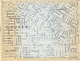
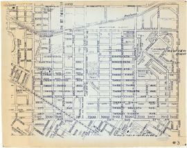
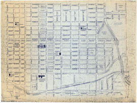
Part of City of Vancouver Archives technical and cartographic drawing collection
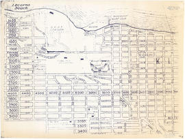
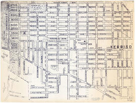
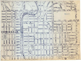
File consists of reproductions of sections of at least three different street maps of Vancouver. The sections show streets, railways, schools and main features of interest.

Part of City of Vancouver Archives technical and cartographic drawing collection
![Plate 80 [Beatty Street to Georgia Street to Hamilton Street to Smithe Street]](/uploads/r/null/d/a/e/daee4ac4066a4e662fb048df52afe5dfc7adc6341a7c055973e46ba1453f8330/505c63b5-b54a-4d4f-bfa1-bce3b08a1f61-1972-582_142.jpg)
Plate 80 [Beatty Street to Georgia Street to Hamilton Street to Smithe Street]
Part of City of Vancouver Archives technical and cartographic drawing collection
![Plate 79 [Canadian Pacific yards to Beach Avenue to Burrard Street to False Creek]](/uploads/r/null/0/d/b/0db6cb152921eb1a151cba66857c8735fd0fedc15a817296747c66d82f27c657/a98e998d-c944-4c90-866d-fd5d59533397-1972-582_142.jpg)
Plate 79 [Canadian Pacific yards to Beach Avenue to Burrard Street to False Creek]
Part of City of Vancouver Archives technical and cartographic drawing collection
![Plate 78 Canadian Pacific yards to Drake Street to Seymour Street to False Creek]](/uploads/r/null/8/1/c/81c7bdb672f0865def3028cba44861754379b4aa98b7dccf45208a5c0e846567/647f56a7-45c0-47e2-b351-acff47aac926-1972-582_142.jpg)
Plate 78 Canadian Pacific yards to Drake Street to Seymour Street to False Creek]
Part of City of Vancouver Archives technical and cartographic drawing collection
![Plate 77 [Seymour Street to Drake Street to Hornby Street to Beach Avenue]](/uploads/r/null/1/e/2/1e2f280818ba9c268a0c3eb37f6c26a3d4e98c44809eaf72f0aa04233923a609/998d7dea-3511-482f-a646-6f87ea4550cd-1972-582_142.jpg)
Plate 77 [Seymour Street to Drake Street to Hornby Street to Beach Avenue]
Part of City of Vancouver Archives technical and cartographic drawing collection
![Plate 76 [Hornby Street to Burnaby/Drake Streets to Thurlow Street to Beach Avenue]](/uploads/r/null/7/8/2/78299212149d18634009b8f3c6d52450dceb47a2edec212c0f3d07f0e65dd5ad/17a1b420-b0c5-47fe-b4b8-27fe165e9ebf-1972-582_142.jpg)
Plate 76 [Hornby Street to Burnaby/Drake Streets to Thurlow Street to Beach Avenue]
Part of City of Vancouver Archives technical and cartographic drawing collection
![Plate 75 [Thurlow Street to Burnaby Street to Bute Street to False Creek]](/uploads/r/null/4/b/3/4b384cf689e0b4df8b172cc49ab4e4ece27aa86ac06485fa0a1a2561a10904cd/15596025-5e83-4f1c-9d78-cc0f7a05832f-1972-582_142.jpg)
Plate 75 [Thurlow Street to Burnaby Street to Bute Street to False Creek]
Part of City of Vancouver Archives technical and cartographic drawing collection
![Plate 74 [Bute Street to Burnaby Street to Broughton Street to English Bay]](/uploads/r/null/f/5/a/f5a676b2dbb5bd50aea3d8da4a8b6063dd0432ae34eab9bac9b63e229bc1c6c1/3a4811f6-9929-4b7e-8c1a-00b514e14dd0-1972-582_142.jpg)
Plate 74 [Bute Street to Burnaby Street to Broughton Street to English Bay]
Part of City of Vancouver Archives technical and cartographic drawing collection
![Plate 73 [Broughton Street to Burnaby Street to Cardero Street to English Bay]](/uploads/r/null/d/4/d/d4d8344fb9fe03f24afb63b7902e1dc6b26c8aee04e7f37f3fa54e97373668ca/09d385e8-fefb-4816-8f4b-9b7cd544a65d-1972-582_142.jpg)
Plate 73 [Broughton Street to Burnaby Street to Cardero Street to English Bay]
Part of City of Vancouver Archives technical and cartographic drawing collection