![Plate 154 [Block east of Birch Street to Sixth Avenue to Hemlock Street to Ninth Avenue]](/uploads/r/null/6/5/2/652ad579c1fe271158b63c84620eb45e6450996406e4ce1091d1ac6397bc6472/eeb6a7b2-820c-4fc4-a3c6-5ab4f86f5aac-1974-100_142.jpg)
Plate 154 [Block east of Birch Street to Sixth Avenue to Hemlock Street to Ninth Avenue]
- AM1594-MAP 625-: 1974-100.58
- Item
- Sept. 1905
Part of City of Vancouver Archives technical and cartographic drawing collection
1440 results with digital objects Show results with digital objects
Plate 154 [Block east of Birch Street to Sixth Avenue to Hemlock Street to Ninth Avenue]
Part of City of Vancouver Archives technical and cartographic drawing collection
![Plate 155 [Spruce Street to Sixth Avenue to block west of Alder Street to Ninth Avenue]](/uploads/r/null/6/1/d/61d627b8bf8255c91caa4dae5c1414b7dea029c2d65ae523e8184113877d5762/9e7d5e21-01bf-448f-8037-73dd4abc4549-1974-100_142.jpg)
Plate 155 [Spruce Street to Sixth Avenue to block west of Alder Street to Ninth Avenue]
Part of City of Vancouver Archives technical and cartographic drawing collection
![Plate 156 [Block east of Oak Street to Sixth Avenue to Spruce Street to Ninth Avenue]](/uploads/r/null/f/8/1/f81307f079a5ed18bb6e49affd7a5f3d3100e9ba3238d592691d04ffeda95499/cad8edde-d5d0-4c5c-b0f8-93ec688a9cb6-1974-100_142.jpg)
Plate 156 [Block east of Oak Street to Sixth Avenue to Spruce Street to Ninth Avenue]
Part of City of Vancouver Archives technical and cartographic drawing collection
![Plate 157 [Willow Street to Sixth Avenue to block west of Laurel Street to Ninth Avenue]](/uploads/r/null/9/5/9/95917226a7f84bd48d88028f6821d6cb5ccdb9dc3b332600d85491dafd7539e6/e2de822d-869f-4fe6-b52b-84c3f4c8baac-1974-100_142.jpg)
Plate 157 [Willow Street to Sixth Avenue to block west of Laurel Street to Ninth Avenue]
Part of City of Vancouver Archives technical and cartographic drawing collection
![Plate 158 [Block east of Heather Street to Sixth Avenue to Willow Street to Ninth Avenue]](/uploads/r/null/0/7/3/0738405a50a60a5b916cf7ad08248de8a02426fff80a1d99e58e7c61e6622531/1a1e7d9a-385f-4b13-a466-c0575de337a4-1974-100_142.jpg)
Plate 158 [Block east of Heather Street to Sixth Avenue to Willow Street to Ninth Avenue]
Part of City of Vancouver Archives technical and cartographic drawing collection
![Plate 159 [Bridge Street to Sixth Avenue to block west of Ash Street to Ninth Avenue]](/uploads/r/null/e/4/4/e44f57cba6b38fa8da6ef44cbb61be076fcf20c0156c0ae088cd88ac1c2d7de9/41ef2962-f94b-4a03-853d-b6e743b5c09f-1974-100_142.jpg)
Plate 159 [Bridge Street to Sixth Avenue to block west of Ash Street to Ninth Avenue]
Part of City of Vancouver Archives technical and cartographic drawing collection
![Plate 160 [Alberta Lumber Co. site and Canadian Pacific siding in Fairview]](/uploads/r/null/5/b/1/5b163141ecec46455912dfb30d20790e28bf16aa914158a79baef3f3ae61914e/dbf5b5d5-d8e6-4ced-8f16-af72e7e15c85-1974-100_142.jpg)
Plate 160 [Alberta Lumber Co. site and Canadian Pacific siding in Fairview]
Part of City of Vancouver Archives technical and cartographic drawing collection
Part consists of a map plate containing two smaller partial plates: the site of the Alberta Lumber Co. mill on False Creek, north of Sixth Avenue and Willow Street; and the Canaidna Pacific Line between Heather Street and Bridge Street and north of Sixth Avenue.
![Plate 161 [Vancouver Lumber Co. site]](/uploads/r/null/8/5/2/852127f39051bf85e540ef01942067e3bc3fcf3dd7a1eb053622d2bd87407c8e/d10bf21c-a276-437b-9032-81dea28defdd-1974-100_142.jpg)
Plate 161 [Vancouver Lumber Co. site]
Part of City of Vancouver Archives technical and cartographic drawing collection
![Plate 162 [Bridge Street to Fourteenth Avenue to Heather Street to Seventeenth Avenue]](/uploads/r/null/5/2/5/5256cff8242defeed25de4521f059690bd7ac034661f9e0b1d3a1d3531ed3d68/6f5bb597-8fce-40e1-bc4f-2ec474b293f1-1974-100_142.jpg)
Plate 162 [Bridge Street to Fourteenth Avenue to Heather Street to Seventeenth Avenue]
Part of City of Vancouver Archives technical and cartographic drawing collection
![Plate 163 [Key Plan of North Vancouver]](/uploads/r/null/e/1/d/e1d59c4aba0a20f0522dd57d1ecfbcc6fa0e15d2cb581616d819932b7b4485b7/be98b40c-82d0-4d47-97d2-e5bc54e3e904-1974-100_142.jpg)
Plate 163 [Key Plan of North Vancouver]
Part of City of Vancouver Archives technical and cartographic drawing collection
![Plate 164 [Lonsdale Avenue to Second Street to Chesterfield Avenue to Burrard Inlet]](/uploads/r/null/b/c/5/bc5801cb1cab9f718c08d5e85247acf3c6c6d41621bd633be9636327b722a9cd/db55d2fa-bc36-4407-a98b-9c062774aa12-1974-100_142.jpg)
Plate 164 [Lonsdale Avenue to Second Street to Chesterfield Avenue to Burrard Inlet]
Part of City of Vancouver Archives technical and cartographic drawing collection
![Plate 165 [St. Georges Road to Second Street to Lonsdale Avenue to Burrard Inlet]](/uploads/r/null/7/4/b/74bf056c6f380a72cc2df80556ee1fab18f65d4b16d8d010c950578becb6ee53/d1a63bcb-2baa-4bed-9444-00a74944242c-1974-100_142.jpg)
Plate 165 [St. Georges Road to Second Street to Lonsdale Avenue to Burrard Inlet]
Part of City of Vancouver Archives technical and cartographic drawing collection
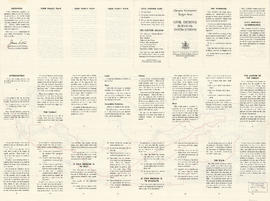
Target area civil defence survival instructions
Part of City of Vancouver Archives technical and cartographic drawing collection

Dispersal routes for the Vancouver zone
Part of City of Vancouver Archives technical and cartographic drawing collection
![Postal Station 3100 Main St [Heritage Hall]](/uploads/r/null/8/b/1/8b139679564262142590dd81b2c5491d7848ce28eca05e97fda33d4c3a926ab1/f091fba5-f25a-4be3-8b2b-1d8c22b37442-1978-215_142.jpg)
Postal Station 3100 Main St [Heritage Hall]
Part of City of Vancouver Archives technical and cartographic drawing collection
Item is an architectural drawing depicting the elevations of Heritage Hall on Main Street and West 15th Avenue.
Canada. Department of Public Works

Postal Station 'C' Mount pleasant : First floor plan
Part of City of Vancouver Archives technical and cartographic drawing collection
Archibald Campbell Hope, Architect
Postal Station 'C' Mount pleasant : Top floor plan
Part of City of Vancouver Archives technical and cartographic drawing collection
Archibald Campbell Hope, Architect
Civic centre : Proposed development for the Burrard Street site
Part of City of Vancouver Archives technical and cartographic drawing collection
Item is an oblique perspective rendering of a proposed civic centre development adjacent to the north end proposed Burrard Street Bridge (approximately the area bounded by the existing Davie, Burnaby, and Bute streets and English Bay).
Harland Bartholomew and Associates
Suggested civic auditorium and stadium on Kitsilano Reserve
Part of City of Vancouver Archives technical and cartographic drawing collection
Item is an oblique rendering depicting a proposed recreation complex in the current location of Vanier Park, near the south end of the Burrard Street Bridge.
Sharp & Thompson, Architects
![Postal Station [Granville and West Hastings streets]](/uploads/r/null/b/4/1/b4186985e2bb9ebae1b8cd849468ad83513d9584e040aa756a42bfb32e28455b/de507cc1-7f65-44cc-a9ea-a7b46caea5c5-1981-010_142.jpg)
Postal Station [Granville and West Hastings streets]
Part of City of Vancouver Archives technical and cartographic drawing collection
Item is an architectural drawing of the Main Post Office building, located at the north-west corner of Granville Street and West Hastings Street in Vancouver. The drawing depicts elevations along Granville and West Hastings streets.
Canada. Department of Public Works
Drawing of J. Lyman Turnbull residence : Lot 14 Blk 798 D.L. 526 (4641 Connaught Drive, Vancouver)
Part of City of Vancouver Archives technical and cartographic drawing collection
Collection contains a photocopy showing floor plans and elevations of the J. Lyman Trumbull residence
Benzie & Bow
Lion's Gate Bridge : Vancouver B.C.
Part of City of Vancouver Archives technical and cartographic drawing collection
Item is a section of the span and footers.
Lion's Gate Bridge : Vancouver B.C.
Part of City of Vancouver Archives technical and cartographic drawing collection
Item is a section of the span and footers.
Trial trip results C.N. No. 558 Builders no. 94 H.M.C.S. "St. Stephen" 4 hour full power trials
Part of City of Vancouver Archives technical and cartographic drawing collection
Item is a chart.
Yarrows Ltd.
Part of City of Vancouver Archives technical and cartographic drawing collection
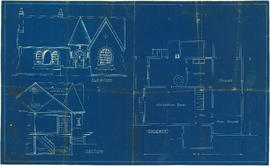
Item is an elevation drawing. The drawing has the following attestation: G.L. Warner Ltd., 1410 Royal Bank Building, Vancouver, B.C., but as this company was an insurance broker and real estate agents, it is unlikely they were responsible for creating the drawing.
It it most likely that the house was never built, as tax records show no improvements to the property until after Mrs. Oram sold it in 1936.
Part of City of Vancouver Archives technical and cartographic drawing collection
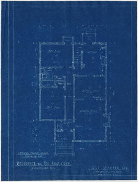
Item is a floor plan. The drawing has the following attestation: G.L. Warner Ltd., 1410 Royal Bank Building, Vancouver, B.C., but as this company was an insurance broker and real estate agents, it is unlikely they were responsible for creating the drawing.

Part of City of Vancouver Archives technical and cartographic drawing collection
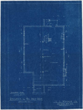
Item is a floor plan. The drawing has the following attestation: G.L. Warner Ltd., 1410 Royal Bank Building, Vancouver, B.C., but as this company was an insurance broker and real estate agents, it is unlikely they were responsible for creating the drawing.
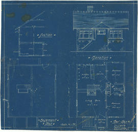
Elevation, section and basement plan
Part of City of Vancouver Archives technical and cartographic drawing collection
Part of City of Vancouver Archives technical and cartographic drawing collection
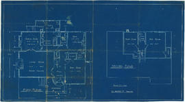
![Bungalow for C. [Cline] Singleton, Vancouver, B.C.](/uploads/r/null/0/e/8/0e8f1fe401cffa704dd33be7ad6a0d055f7ec516ba1d63dd924193e18c708652/396919ff-1214-495c-861e-1b7aa2dada84-1987-017_142.jpg)
Bungalow for C. [Cline] Singleton, Vancouver, B.C.
Part of City of Vancouver Archives technical and cartographic drawing collection
Item is an architectural drawing which contains front and side elevations, section, floor plan and schedule of doors.

Part of City of Vancouver Archives technical and cartographic drawing collection
S.W. Hopper Ltd.
Part of City of Vancouver Archives technical and cartographic drawing collection

Part of City of Vancouver Archives technical and cartographic drawing collection

Part of City of Vancouver Archives technical and cartographic drawing collection
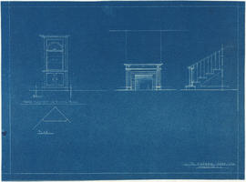
China cabinet, fireplace and staircase elevations
Part of City of Vancouver Archives technical and cartographic drawing collection
Front elevation : Leyland Apartments 916 West Broadway
Part of City of Vancouver Archives technical and cartographic drawing collection
1st floor plan [Leyland Apartments?]
Part of City of Vancouver Archives technical and cartographic drawing collection
Apartment house at 1307 Fifteenth Avenue, Vancouver, B.C. for R.C. Singleton
Part of City of Vancouver Archives technical and cartographic drawing collection
Item is an architectural drawing of the apartment building currently addressed as 1315 West 15th Avenue. The drawing depictsa lot plan; front, east and rear elevations; and a section.
Gillingham, H.H.

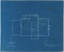
Floor plans for unidentified house
Part of City of Vancouver Archives technical and cartographic drawing collection
Item is an architectural drawing which depicts basement and first floor plans.
![Parsons [?] house, North Vancouver](/uploads/r/null/4/d/1/4d1a653fefee3c4d6bdc3e7b5e7b6a293edde702a9d6ec8cfa2f60164ee137df/f0773310-1258-409a-85b8-b5f79a6a8dc9-1987-017_142.jpg)
Parsons [?] house, North Vancouver
Part of City of Vancouver Archives technical and cartographic drawing collection
Item is an architectural drawing of a bungalow; the drawing depicts basement and ground floor plans, front elevation and section.
Drawing for unidentified bungalow
Part of City of Vancouver Archives technical and cartographic drawing collection
Item is an architectural drawing, which depicts basement and floor plans, section and front elevation.

Drawing for unidentified bungalow
Part of City of Vancouver Archives technical and cartographic drawing collection
Item is an architectural drawing which depicts basement and floor plans, front elevation and section.

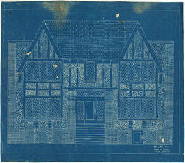
Vancouver Opera House front elevation
Part of City of Vancouver Archives technical and cartographic drawing collection
Item is an architectural drawing of the first Vancouver Opera House. The drawing appears to be of the design as originally constructed in 1890/91.

Vancouver Opera House half elevation of street front
Part of City of Vancouver Archives technical and cartographic drawing collection
Item is an architectural drawing of the first Vancouver Opera House. The drawing appears to be of the design as originally constructed in 1890/91.
Vancouver Opera House basement plan
Part of City of Vancouver Archives technical and cartographic drawing collection
Item is an architectural drawing of the first Vancouver Opera House. The drawing appears to be of the design as originally constructed in 1890/91.
Vancouver Opera House plan of balcony
Part of City of Vancouver Archives technical and cartographic drawing collection
Item is an architectural drawing of the first Vancouver Opera House. The drawing appears to be of the design as originally constructed in 1890/91.

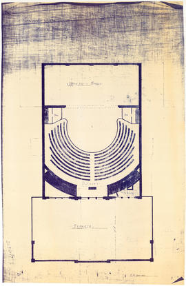
Vancouver Opera House ground floor plan
Part of City of Vancouver Archives technical and cartographic drawing collection
Item is an architectural drawing of the first Vancouver Opera House. The drawing appears to be of the design as originally constructed in 1890/91.

Vancouver Opera House plan of gallery
Part of City of Vancouver Archives technical and cartographic drawing collection
Item is an architectural drawing of the first Vancouver Opera House. The drawing appears to be of the design as originally constructed in 1890/91.

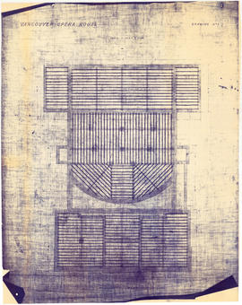
Vancouver Opera House plan of roof timbers
Part of City of Vancouver Archives technical and cartographic drawing collection
Item is an architectural drawing of the first Vancouver Opera House. The drawing appears to be of the design as originally constructed in 1890/91.

Vancouver Opera House transverse section
Part of City of Vancouver Archives technical and cartographic drawing collection
Item is an architectural drawing of the first Vancouver Opera House. The drawing appears to be of the design as originally constructed in 1890/91.