
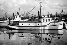
Lipsett boats - "Harris No.3", "Hollyburn"
- AM1545-S3-: CVA 586-5397
- Item
- Jan. 1945
462 results with digital objects Show results with digital objects
Lipsett boats - "Harris No.3", "Hollyburn"


Vancouver Harbour : plan of south shore, Burrard Inlet between Heatley Ave. and Victoria Dr.
Part of City of Vancouver Archives technical and cartographic drawing collection
Item is a map which shows parcels of land along Burrard Inlet and district lots in downtown Vancouver. Piers, factories and mills along the waterfront are identified. Soundings are shown in feet.
National Harbours Board

Vancouver Harbour : Sheet 1 (First Narrows to Second Narrows)
Part of City of Vancouver Archives technical and cartographic drawing collection
Item is a nautical chart of Vancouver Harbour from First Narrows in the west to Second Narrows in the east, showing soundings in fathoms, tidal information, anchorages, beacons, and waterfront businesses. Street names are shown on land areas.

Vancouver Harbour : Sheet 2 (Point Grey to Second Narrows)
Part of City of Vancouver Archives technical and cartographic drawing collection
item is a nautical chart of Burrard Inlet and Vancouver Harbour from Point Grey in the west to Second Narrows in the east, showing soundings in fathoms, tidal information, anchorages, beacons, and waterfront businesses. Street names are shown on land areas. A Royal Canadian Air Force bombing range at Jericho Beach is identified as a danger area.
By-laws of the National Harbours Board (Vancouver Harbour)
![Fishing boats at Prince Rupert [docks]](/uploads/r/null/5/7/57cad72795de5981d5a1b74a4b6e885953b245c18485282f0028b8559053341c/2d2e9b4d-9594-40be-8441-6632a03ff306-A07220_142.jpg)
Fishing boats at Prince Rupert [docks]
Thor and Mikof boats indentified in photograph.
![[View of] Ocean Falls [from harbour]](/uploads/r/null/a/c/ac01a62213024629cc4ad1b26c89a5bc072b7b6495192754174509e3aa713da0/d414e587-97bb-4d8e-99e2-b8f5ef2471f8-A07225_142.jpg)
[View of] Ocean Falls [from harbour]
![[View of] Ocean Falls [harbour and buildings]](/uploads/r/null/3/3/33daeb90796231f592329cba7a2cbd32a2d2e5ec9d397a7151a925a416d514b8/860dc270-0c78-4f59-9c8e-a01712ccce45-A07221_142.jpg)
[View of] Ocean Falls [harbour and buildings]
![[View of] Deep Cove](/uploads/r/null/1/a/1a18c33f69dd89ad4f2e79c0137c837c16e817069547777a7c1f9daf2542a46f/4fe48ffe-0985-498a-acd7-92c6d74245b0-A03406_142.jpg)
![[Views of boats in] Deep Cove [harbour]](/uploads/r/null/b/9/b9f273fdf8c32c5165d86836e5ca1d3f2c41548f1aec61f7261df0be041d12a8/6a46c1b6-9ded-4685-a959-ced739e246f2-A03405_142.jpg)
[Views of boats in] Deep Cove [harbour]
![[View of] Victoria Harbour](/uploads/r/null/6/6/66255e20916ef61cdcddf8833e5435b5075fb8b4f1e38bb884404510b2681df9/75af0c66-cf6f-4376-aba9-e67a74aa198f-A06938_142.jpg)
Inscription on verso of print "Inner Harbour and Parliament Bldg. Victoria, B.C.
Part of Major Matthews collection
Oblique view looking northeast showing the Denman Arena, the Georgia Street entrance to Stanley Park, the Vancouver Rowing Club, Brockton Point and Deadmans Island
![[View of Victoria Harbour an] Parliament Buildings](/uploads/r/null/9/2/92c1339ecc880e2165a05beaee358355b4c5da0b6c0f0d6742919864aa275115/1498ef9f-3d2b-4af3-b61e-dfaa48987973-A07157_142.jpg)
[View of Victoria Harbour an] Parliament Buildings


View shows Lions Gate Bridge and Stanley Park.
![Georgia Day [on the deck of a] Vancouver-Victoria boat in First Narrows](/uploads/r/null/6/6/668581126068bef64727574d042412d1492c0510d297779d4bfda0ebf271604a/5b6dd093-9969-4960-850f-995e137a5ca3-A03305_142.jpg)
Georgia Day [on the deck of a] Vancouver-Victoria boat in First Narrows
![[View of] Victoria Harbour](/uploads/r/null/0/7/074ebb16365cb625f74f47be3cfe3f0ae2a9a727d6c149abfcbba485f959f53b/b1a27d9b-dbad-4511-be41-95bf15ef2fc1-A06937_142.jpg)
![[View of] Parliament Building , illuminated [at night, Victoria, B.C.]](/uploads/r/null/d/c/dc81d0d58c91faf1768ff62befeceee86d29ea5df52f6d2f0480ecd47adac3ec/efed1773-3d50-494b-8786-acab1c88657f-A06943_142.jpg)
[View of] Parliament Building , illuminated [at night, Victoria, B.C.]


Prince Rupert buildings and harbour

Vancouver Harbour : Sheet 3 (Second Narrows to Port Moody)
Part of City of Vancouver Archives technical and cartographic drawing collection
Item is a nautical chart of Vancouver Harbour from Second Narrows in the west to Port Moody in the east, showing soundings in fathoms, tidal information, anchorages, beacons, and waterfront businesses. Street names are shown on land areas.
![[View of] Victoria harbour](/uploads/r/null/2/e/2e8a0985a175dda5a26fef759d34134718505995fe8437669cf13a56c6b48c14/4e29bce9-209b-4aa9-b1f8-297e9d626dec-A07060_142.jpg)
Vancouver Harbour : sightseeing tours
"A trip that will linger long as a pleasant memory of Vancouver."
![[View of the harbour from Spencer's Department Store]](/uploads/r/null/2/0/202e8d9d731fb703dfc9c1c09d19f811ee159ca535e8b61865f31dadd624551c/2a899800-eecb-49bd-9760-2d8c09ed120c-A09877_142.jpg)
[View of the harbour from Spencer's Department Store]
Part of Major Matthews collection
Photograph shows Canadian Pacific Railway piers 'B' and 'D'.
Vancouver skyline from Coal Harbour [Boats docked in marina: "Cohoe Bay" and "Sal Lal"]
Part of Karl Haspel fonds
![Mr. G.B. Warren, Pacific Motor Boat, loading yachts on scow [False Creek]](/uploads/r/null/f/2/f232cac9c03fef859e1f5924b275b39d362d773c6832127117a54cac2812e910/5efc456e-cf3b-46c8-a964-4e3d5bb91ce3-A01562_142.jpg)
Mr. G.B. Warren, Pacific Motor Boat, loading yachts on scow [False Creek]
Part of Stuart Thomson fonds
![Mr. G.B. Warren, Pacific Motor Boat, loading yachts on scow [False Creek South]](/uploads/r/null/3/d/3d64427c867440e7d963d876580d7a96d4e51be7df567c1fc70173c55e3642d4/bca9a4db-6ce1-43f2-a5a9-4093881390a7-A01560_142.jpg)
Mr. G.B. Warren, Pacific Motor Boat, loading yachts on scow [False Creek South]
Part of Stuart Thomson fonds
![Mr. G.B. Warren, Pacific Motor Boat, loading yachts on scow [False Creek]](/uploads/r/null/3/d/3de4a6c7f897b524e96125c76b31a4f9cc8f0fdb760b732c70e777151e599f8e/538827c0-3fdd-4563-8064-633ec45e13e4-A01561_142.jpg)
Mr. G.B. Warren, Pacific Motor Boat, loading yachts on scow [False Creek]
Part of Stuart Thomson fonds
Imperial Gasoline signboard in background.

Part of Major Matthews collection
Item is a photograph of a painting of the scene depicted in the image with the identifier SGN 155.
![[View across Coal Harbour towrds Downtown]](/uploads/r/null/d/d/ddf2d63627f742e05eab0ed197b3b40bc910fd24a176af8b9a75db9e2dd8133c/db7f74b3-f519-43e2-af80-62d88342cfea-A74506_142.jpg)
[View across Coal Harbour towrds Downtown]
Part of James Crookall fonds
Photograph shows the Marine Building and the Hotel vancouver in the background
![[View of Coal Harbour from the causeway]](/uploads/r/null/a/1/a11c5844a676582424273c284cfec188f2dfc6c90cb9dd46a741be593d2a3456/caed5a3c-25db-483c-8ad9-fde5e565c38b-A75614_142.jpg)
[View of Coal Harbour from the causeway]
Part of James Crookall fonds
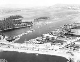
![[Aerial view of Vancouver Harbour looking east from Lost Lagoon]](/uploads/r/null/a/7/a7c598133f7f2c78a6bb65602262bc193ceb787389db5cd31ded3868025265ca/72eb674f-7c20-4ecc-a618-3a1e88e660c8-A62798_142.jpg)
[Aerial view of Vancouver Harbour looking east from Lost Lagoon]
Part of Major Matthews collection
Oblique view showing Coal Harbour, Deadman's Island, Denman Arena, the Marine and other buildings, and the piers along the waterfront
Part of City of Vancouver Archives technical and cartographic drawing collection
Item is a brochure promoting tourism along the British Columbia coast using Union Steamships routes. The unfolded brochure has text and illustrations on one side and on the other text with a map showing the routes to destinations described in the brochure.
![V.R.C. [Vancouver Rowing Club] Four & Double Crews for St. Catherines taken for Province [Coa...](/uploads/r/null/4/1/412abfd7acce1adb4cf991702a000fc50078e41d8f421a8fa725952a221a01fa/94279fbc-2dbd-412c-a040-10e1780bac99-A01461_142.jpg)
Part of Stuart Thomson fonds

Vancouver Rowing Club Eight at V.R.C. spring regatta
Part of Stuart Thomson fonds
Photograph shows

Vancouver Rowing Club spring regatta at Coal Harbour
Part of Stuart Thomson fonds
Photograph shows spectators on wharf, arena in the background. The teams are the eights for the Vancouver Rowing Club and the University of Washington.

Vancouver Rowing Club spring regatta University of Washington Eight
Part of Stuart Thomson fonds

Port of the City of Vancouver. Isometric view from the south-west
Part of City of Vancouver Archives technical and cartographic drawing collection
Item is a set of maps printed on one sheet. The main map shows an isometric view of the port of Vancouver from Stanley Park through the Second Narrows Bridge (including North Vancouver). The perspective point appears to be located above the Granviile Street and West Georgia Street intersection. Note that the isometric view of locations west of Granville Street is from the south-east, rather than the south-west, as indicated in the title.
The map depicts the port infrastructure, including piers, drydocks and companies located in the port.
The inset maps are a key plan showing the location of the port relative to the Lower Mainland as a whole, and a larger-scale map entitled "Plan of the Port of the City of Vancouver from Coal Harbour to Second Narrows". It contains more detail about the names of the various piers, drydocks and companies and shows the North Vancouver port facilities as well as south shore ones.

Vancouver Harbour, British Columbia, 1932
Part of City of Vancouver Archives technical and cartographic drawing collection
Item is a nautical chart showing English Bay and Burrard Inlet with soundings in feet, anchorages, locations of submarine cables, and ferry lines. Land features include city blocks and district lot numbers. Includes inset maps of the North Arm of Burrard Inlet and Vancouver Island.

Royal Vancouver Yacht Club "Kittens" racing at Burrard Inlet
Part of Stuart Thomson fonds
![Vancouver Rowing Club Regatta [Coal Harbour - view toward downtown]](/uploads/r/null/c/9/c92acf40df14c613b1c87493db95b06f17823f0cab28e27c6ec65c573423b20e/163c0efd-604d-4021-87ad-d44053f0b5d0-A01209_142.jpg)
Vancouver Rowing Club Regatta [Coal Harbour - view toward downtown]
Part of Stuart Thomson fonds

Canadian National Railways steamship "Prince Robert" leaving harbour
Part of Stuart Thomson fonds
!["Empress of Japan" [entering harbour]](/uploads/r/null/5/4/54daa95b650752aac57e4cceb46eb7a800ab476a2d6485b7a3586dd536f82808/b5b1f904-8a7c-4d4a-8337-79ac1cbc3d25-A01178_142.jpg)
"Empress of Japan" [entering harbour]
Part of Stuart Thomson fonds
!["Empress of Japan" [entering harbour]](/uploads/r/null/b/a/ba6c6572d5ff93b5600b383a188a950baaeced82f6ca31580146901ef93f726a/796da2b6-d80c-419b-8ccf-b65e1eb87326-A01179_142.jpg)
"Empress of Japan" [entering harbour]
Part of Stuart Thomson fonds
!["Empress of Japan" [entering harbour]](/uploads/r/null/2/4/24ce4e142bf059fe41f6621fd36efaa86fbfaf57c84f79a0a1d35700523d7944/e5eaea3e-81da-4866-8dda-08316f84e16d-A01177_142.jpg)
"Empress of Japan" [entering harbour]
Part of Stuart Thomson fonds
![[Pleasure craft "Nancy Anne" in Vancouver harbour]](/uploads/r/null/1/3/13b6ac315dee3da205f9203b95f29302530f9286c51efa1275e89959809d81cd/278bbf2e-36a6-4f3e-894f-2520057d91de-A01228_142.jpg)
[Pleasure craft "Nancy Anne" in Vancouver harbour]
Part of Stuart Thomson fonds