![Sheet 35B [Arbutus Street to Oliver Crescent to Trafalgar Street to 33rd Avenue]](/uploads/r/null/1/a/2/1a2dae58c54e4548c9e25079a7b41f6d3472f8dd36ca64d6f04d815f73db8abe/c3e1cf13-4fdf-4061-b0af-8ae3dea6b465-LEG1153_142.jpg)
Sheet 35B [Arbutus Street to Oliver Crescent to Trafalgar Street to 33rd Avenue]
- PUB-: PD 2135-: LEG1153.264
- Part
- [ca. 1955] (copied ca. 1980)
Part of City publications collection
504 results with digital objects Show results with digital objects
Sheet 35B [Arbutus Street to Oliver Crescent to Trafalgar Street to 33rd Avenue]
Part of City publications collection
![Sheet 35C [Trafalgar Street to 33rd Avenue to Blenheim Street to 41st Avenue]](/uploads/r/null/2/f/d/2fd752d3f48aa7cecdf56eb40b0a5bde82183a3957844ce8de8abe3f927394b5/6571bf0a-fe92-44d6-8d05-61611fba1aa2-LEG1153_142.jpg)
Sheet 35C [Trafalgar Street to 33rd Avenue to Blenheim Street to 41st Avenue]
Part of City publications collection
![Sheet 35D [Maple Street to 33rd Avenue to Trafalgar Street to 41st Avenue]](/uploads/r/null/7/9/8/7987bd1c1f725393a88386327cd49a88796915b005335815fa2b60292a3be3c1/106eb975-21b1-4180-a45b-60007180aa72-LEG1153_142.jpg)
Sheet 35D [Maple Street to 33rd Avenue to Trafalgar Street to 41st Avenue]
Part of City publications collection
![Sheet 36A [Trafalgar Street to 41st Avenue to Blenheim Street to 49th Avenue]](/uploads/r/null/2/8/4/28460f6a324d3a76d6e4b6164988efd9eae41a90614f984a6108a03436add80d/a5c058b4-8ee2-4bad-b10e-7b990bc2e566-LEG1153_142.jpg)
Sheet 36A [Trafalgar Street to 41st Avenue to Blenheim Street to 49th Avenue]
Part of City publications collection
![Sheet 36B [Maple Street to 41st Avenue to Trafalgar Street to 49th Avenue]](/uploads/r/null/a/4/0/a40c683a4e05e13a0b2788be31d5bd9e052323e28a1c760c2c1370625278ab20/7377513a-5067-46ca-bc51-fb94fc7fdc29-LEG1153_142.jpg)
Sheet 36B [Maple Street to 41st Avenue to Trafalgar Street to 49th Avenue]
Part of City publications collection
![Sheet 36C [Macdonald Street to 49th Avenue to Blenheim Street to 57th Avenue]](/uploads/r/null/5/4/1/54138fec7561b8cf27a9e2fd7bc4302cf88635da8b1ab64a0dc83f55e043b88f/85ab9341-1e7c-4eb0-8827-e02a73e98c76-LEG1153_142.jpg)
Sheet 36C [Macdonald Street to 49th Avenue to Blenheim Street to 57th Avenue]
Part of City publications collection
![Sheet 36D [Laburnum Street to 49th Avenue to Marine Crescent to 57th Avenue]](/uploads/r/null/c/7/b/c7b470b131a974a25cfdc40ecc04f9e7436cdb7153fc41fce2efe37332fbae5d/ece1b1b3-c1f3-4c8d-9172-ea5f878ec014-LEG1153_142.jpg)
Sheet 36D [Laburnum Street to 49th Avenue to Marine Crescent to 57th Avenue]
Part of City publications collection
![Sheet 37A [Macdonald Street to 57th Avenue to Blenheim Street to Fraser River]](/uploads/r/null/9/5/a/95aa079bef47009f14df3f8771db0039f5737dd4c69e6853618c42969bdb4f28/b8c6caea-b7c9-43ee-8721-d033baaa1605-LEG1153_142.jpg)
Sheet 37A [Macdonald Street to 57th Avenue to Blenheim Street to Fraser River]
Part of City publications collection
![Sheet 37B [Arbutus Street to 57th Avenue to Macdonald Street to Fraser River]](/uploads/r/null/8/9/6/896b19b19be5990995a1cc1650cc56b8b95b41edabc7275d7599ff9daba24a10/6fa43256-5f1f-4c4e-8827-d31f15059905-LEG1153_142.jpg)
Sheet 37B [Arbutus Street to 57th Avenue to Macdonald Street to Fraser River]
Part of City publications collection
![Sheet 37D [Arbutus Street to SW Marine Drive to Yew Street to Fraser River]](/uploads/r/null/e/5/a/e5aa2aae86553141e6823eeb67fd0bb9703daffd5797730546a140a6385f3969/3923280b-492e-4b85-8046-96702ef629fa-LEG1153_142.jpg)
Sheet 37D [Arbutus Street to SW Marine Drive to Yew Street to Fraser River]
Part of City publications collection
![Sheet 38A [Wallace Street to English Bay to Discovery Street to Point Grey Road]](/uploads/r/null/3/8/f/38f7cee0d8d7652a09e55d556882175be49a35f450edbdae8537cf4bb5020953/7200fed2-d028-45f4-9c42-ddb263833ea1-LEG1153_142.jpg)
Sheet 38A [Wallace Street to English Bay to Discovery Street to Point Grey Road]
Part of City publications collection
![Sheet 38B [Blenheim Street to English Bay to Wallace Street to 1st Avenue]](/uploads/r/null/7/1/c/71c5407e67cc3bff4e6b39267909502a9758927b3486198fad64719913492e16/8d7dae69-670c-4866-83fd-de62092e22e8-LEG1153_142.jpg)
Sheet 38B [Blenheim Street to English Bay to Wallace Street to 1st Avenue]
Part of City publications collection
![Sheet 38C [Wallace Street to 2nd Avenue to Discovery Street to 10th Avenue]](/uploads/r/null/0/d/a/0da3214ef3428e25131b7b886736d51eea93a3faa646d4436cfb4209cd137dd3/71f51381-e004-4c8d-8c48-75cfe95363d4-LEG1153_142.jpg)
Sheet 38C [Wallace Street to 2nd Avenue to Discovery Street to 10th Avenue]
Part of City publications collection
![Sheet 38D [Blenheim Street to 1st Avenue to Wallace Street to 10th Avenue]](/uploads/r/null/2/4/a/24a75dbb7f7bbe44a899c43d154e4ca6379e01a60c49e440460c0a47aae9d526/e23bc31f-1f4e-4e9c-9170-7bca8fc14020-LEG1153_142.jpg)
Sheet 38D [Blenheim Street to 1st Avenue to Wallace Street to 10th Avenue]
Part of City publications collection
![Sheet 39A [Wallace Street to 10th Avenue to Discovery Street to 16th Avenue]](/uploads/r/null/d/e/6/de6660a119a0cdd1d10c1297f2cf1c2b4552e9ddec3edf92644013f9cc15e2e1/07059a40-a2f4-4334-9056-d62c618151ec-LEG1153_142.jpg)
Sheet 39A [Wallace Street to 10th Avenue to Discovery Street to 16th Avenue]
Part of City publications collection
![Sheet 39B [Blenheim Street to 10th Avenue to Wallace Street to 16th Avenue]](/uploads/r/null/b/8/e/b8e886c2e0544e1fcda547b926b902923ea6af25ef89e2aced11cf73832c5930/841000f9-3cf2-40b4-ace7-9c69ed16d64d-LEG1153_142.jpg)
Sheet 39B [Blenheim Street to 10th Avenue to Wallace Street to 16th Avenue]
Part of City publications collection
![Sheet 39C [Wallace Street to 16th Avenue to Discovery Street to King Edward Avenue]](/uploads/r/null/2/5/c/25c5aa22e403558f96fbd40e3ae0947be0ace24e232e953b87a2fb754b3fb1a3/ff315df3-3abc-48e3-b95c-305139a29e88-LEG1153_142.jpg)
Sheet 39C [Wallace Street to 16th Avenue to Discovery Street to King Edward Avenue]
Part of City publications collection
![Sheet 39D [Blenheim Street to 16th Avenue to Wallace Street to King Edward Avenue]](/uploads/r/null/0/6/5/0655bd0bc18c1c8d272023db21bec0565c5601b72c35586e5a716935161e4650/caafb621-700d-4541-8b4d-320e88161db9-LEG1153_142.jpg)
Sheet 39D [Blenheim Street to 16th Avenue to Wallace Street to King Edward Avenue]
Part of City publications collection
![Sheet 40A [Wallace Street to King Edward Avenue to Univsity Endowment Lands to 33rd Avenue]](/uploads/r/null/f/1/f/f1fd90433a6a288ac0a5c1cf28ccdf3020b21d50e9ccff5ce6c7f752a26ab030/c53b5933-6833-4457-8b54-75aa04b81180-LEG1153_142.jpg)
Sheet 40A [Wallace Street to King Edward Avenue to Univsity Endowment Lands to 33rd Avenue]
Part of City publications collection
![Sheet 40B [Blenheim Street to King Edward Avenue to Wallace Street to 33rd Avenue]](/uploads/r/null/a/d/0/ad02d0ef5c1b93f161c46247cc4614b2d56e9cd6a9ff6160d8287e89942f9956/9dd41d25-161b-4003-854d-d02e9a9898ff-LEG1153_142.jpg)
Sheet 40B [Blenheim Street to King Edward Avenue to Wallace Street to 33rd Avenue]
Part of City publications collection
![Sheet 40C [Wallace Street to 33rd Aenue to University Endowment Lands to 41st Avenue]](/uploads/r/null/8/5/6/856a4a832f68fa55c97dfecc6eed8ea78f09e3a96b2c14401b6340f61ae6fff8/85d634e1-5e30-45cf-a659-80c3efa9bf27-LEG1153_142.jpg)
Sheet 40C [Wallace Street to 33rd Aenue to University Endowment Lands to 41st Avenue]
Part of City publications collection
![Sheet 40D [Blenheim Street to 33rd Avenue to Wallace Street to 41st Avenue]](/uploads/r/null/3/7/3/3739bbdbc18fbe16d7162de0c6e02dde7965bc02d740ce4e4df465537ac85e04/89aa8116-832b-4979-9033-15d44b002b1f-LEG1153_142.jpg)
Sheet 40D [Blenheim Street to 33rd Avenue to Wallace Street to 41st Avenue]
Part of City publications collection
![Sheet 41A [Wallace Street to 41st Avenue to Musqueam Reserve to 49th Avenue]](/uploads/r/null/d/7/f/d7f1e8bd92ef76bcd7457d96a14646d040f9cc8a043fa474a88dbf056606dd90/cbe2dfc1-4957-4833-9e0f-6bb7f1d3c6a8-LEG1153_142.jpg)
Sheet 41A [Wallace Street to 41st Avenue to Musqueam Reserve to 49th Avenue]
Part of City publications collection
![Sheet 41B [Blenheim Street to 41st Avenue to Wallace Street to 49th Avenue]](/uploads/r/null/7/b/2/7b2dd608c9e447bf448dcfc09ed76f8691e4c1e216e012b1b2e2776c5196a218/ad8b9cc6-c5a4-4aa4-8286-2fb92afe4f82-LEG1153_142.jpg)
Sheet 41B [Blenheim Street to 41st Avenue to Wallace Street to 49th Avenue]
Part of City publications collection
![Sheet 41D [Blenheim Street to 49th Avenue to Musqueam Reserve to Fraser River]](/uploads/r/null/e/9/2/e92fc5827e22fcead9e0370739bc0dfbf09b3591c72f423289effff3fdd52ebe/55542ee4-2c2b-4357-ad50-9c533e59a857-LEG1153_142.jpg)
Sheet 41D [Blenheim Street to 49th Avenue to Musqueam Reserve to Fraser River]
Part of City publications collection
![Sheet 42B [Blenheim Street to Celtic Avenue to Fraser River]](/uploads/r/null/d/0/f/d0f904ceb3f9e449b3756ccfde3fdf618ac91b559883559e2cc0e567d57d7a15/c8590d75-7fb0-42c1-b582-67f9b91bfed6-LEG1153_142.jpg)
Sheet 42B [Blenheim Street to Celtic Avenue to Fraser River]
Part of City publications collection
![Sheet 43A [Blanca Street to English Bay to University Endowment Lands to 2nd Avenue]](/uploads/r/null/1/c/b/1cb8433ea45730d34fcc1fe1f92271f79a3eaa3903473a761e4f878170fa5191/ff8939af-97c6-4154-acc1-0d8a868fc66f-LEG1153_142.jpg)
Sheet 43A [Blanca Street to English Bay to University Endowment Lands to 2nd Avenue]
Part of City publications collection
![Sheet 43B [Discovery Street to English Bay to Blanca Street to 2nd Avenue]](/uploads/r/null/2/1/0/21007a691605ce3411c27c74a7e68e1ecc145d09c86feadc96ecb9b090f3c96e/bff71469-8c56-4157-b106-946d78ab28bd-LEG1153_142.jpg)
Sheet 43B [Discovery Street to English Bay to Blanca Street to 2nd Avenue]
Part of City publications collection
![Sheet 43C [Blanca Street to 2nd Avenue to University Endowment Lands to 10th Avenue]](/uploads/r/null/8/e/a/8ea10dc3c6492327a5e0addd9018cab3617de431e837beda4233bb94d8c2db98/d339ad6e-552a-4c6c-a353-a547405cbf57-LEG1153_142.jpg)
Sheet 43C [Blanca Street to 2nd Avenue to University Endowment Lands to 10th Avenue]
Part of City publications collection
![Sheet 44B [Discovery Street to 10th Avenue to Blanca Street to 16th Avenue]](/uploads/r/null/0/f/7/0f7db59d1a90e970d1a27d525155c52735957e90e75e1142b86be956483805d9/ff72da6d-d789-4ce6-9b3d-9361505882c7-LEG1153_142.jpg)
Sheet 44B [Discovery Street to 10th Avenue to Blanca Street to 16th Avenue]
Part of City publications collection

Part of City of Vancouver fonds

Welwyn Street to Rupert Street
Part of City of Vancouver fonds

Rupert Street to Boundary Road
Part of City of Vancouver fonds

Part of City of Vancouver fonds
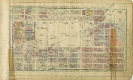
Part is a section depicting the area bounded by Boundary Road to Burrard Inlet to Slocan Street to Triumph Street. The sheet has been extensively annotated, with colour coded areas to depict land use, status of lots as tax sale properties for sale, sewer and water lines, as well as other colour codes that are not noted on the legend at the front of the volume.

Vancouver section 2 supplementary information
Part of City of Vancouver fonds
Part is a sheet showing information noted about assessments and other information relevant to Vancouver section 2.

Part of City of Vancouver fonds
Part is a section depicting the area bounded by Boundary Road to Triumph Street to Slocan Street to Charles Street. The sheet has been extensively annotated, with colour coded areas to depict land use, status of lots as tax sale properties for sale, sewer and water lines, as well as other colour codes that are not noted on the legend at the front of the volume.

Vancouver section 3 supplementary information
Part of City of Vancouver fonds
Part is a sheet showing information noted about assessments and other information relevant to Vancouver section 3.

Part of City of Vancouver fonds
Part is a section depicting the area bounded by Boundary Road to Charles Street to Slocan Street to Seventh Avenue. The sheet has been extensively annotated, with colour coded areas to depict land use, status of lots as tax sale properties for sale, sewer and water lines, as well as other colour codes that are not noted on the legend at the front of the volume.
Vancouver section 4 supplementary information
Part of City of Vancouver fonds
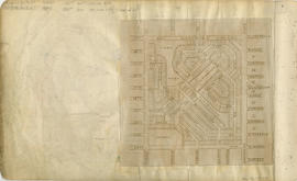
Part is a sheet showing information noted about assessments and other information relevant to Vancouver section 4. The sheet also includes a small map of the redevelopment of the are bounded by Boundary Road to 13th Avenue to Rupert Street to 22nd Avenue.
Part of City of Vancouver fonds
Part is a section depicting the area bounded by Boundary Road to Seventh Avenue to Slocan Street to Seventeenth Avenue.

Vancouver section 5 supplementary information
Part of City of Vancouver fonds
Part is a sheet showing information noted about assessments and other information relevant to Vancouver section 5.

Part of City of Vancouver fonds
Part is a section depicting the area bounded by Boundary Road to Seventeenth Avenue to Slocan Street to Twenty-ninth Avenue. The sheet has been extensively annotated, with colour coded areas to depict land use, status of lots as tax sale properties for sale, sewer and water lines, as well as other colour codes that are not noted on the legend at the front of the volume.

Vancouver section 6 supplementary information
Part of City of Vancouver fonds
Part is a sheet showing information noted about assessments and other information relevant to Vancouver section 6.

Part of City of Vancouver fonds
Part is a section depicting the area bounded by Slocan Street to Eighteenth Avenue to Knight Street to Twenty-ninth Avenue. The sheet has been extensively annotated, with colour coded areas to depict land use, status of lots as tax sale properties for sale, sewer and water lines, as well as other colour codes that are not noted on the legend at the front of the volume.

Vancouver section 7 supplementary information
Part of City of Vancouver fonds
Part is a sheet showing information noted about assessments and other information relevant to Vancouver section 7.

Part of City of Vancouver fonds
Part is a section depicting the area bounded by Slocan Street to Seventh Avenue to Clark Drive to Eighteenth Avenue. The sheet has been extensively annotated, with colour coded areas to depict land use, status of lots as tax sale properties for sale, sewer and water lines, as well as other colour codes that are not noted on the legend at the front of the volume.

Vancouver section 8 supplementary information
Part of City of Vancouver fonds
Part is a sheet showing information noted about assessments and other information relevant to Vancouver section 8.

Part of City of Vancouver fonds
Part is a section depicting the area bounded by Slocan Street to William Street to Clark Drive to Seventh Avenue. The sheet has been extensively annotated, with colour coded areas to depict land use, status of lots as tax sale properties for sale, sewer and water lines, as well as other colour codes that are not noted on the legend at the front of the volume.

Vancouver section 9 supplementary information
Part of City of Vancouver fonds
Part is a sheet showing information noted about assessments and other information relevant to Vancouver section 9.

Part of City of Vancouver fonds
Part is a section depicting the area bounded by Slocan Street to Triumph Street to Clark Drive to William Street. The sheet has been extensively annotated, with colour coded areas to depict land use, status of lots as tax sale properties for sale, sewer and water lines, as well as other colour codes that are not noted on the legend at the front of the volume.